Timothy Bechtold, David Havlick, Keith Stockmann
Analysis of
Road Densities in
Selected Grizzly Bear Management Units
in the Northern
Rockies
Abstract
The wildlands of the Northern Rockies continue to diminish in size, primarily due
to new road building and the associated industries, such as logging and mining,
that demand, build, and utilize roads. As roadless lands decrease, secure
habitat for grizzly bears and other wildlife species sensitive to roads decreases
as well. The ecological effects of roads on wildlife and habitat quality have
been well documented as one of the most important factors that contribute to
ecosystem disruption and degradation. This analysis, known as the
"Roads Scholar Project," combined aerial
photo and map inventories with field surveys and GIS, to identify, assess,
analyze, and display the current conditions of roaded wildlife habitat in
selected management units in Montana, northern Idaho, eastern Washington, and
northwestern Wyoming. In each instance, the US Forest Service's management of
its roads system has been found to be inadequate, either due to unidentified
travelways that exist on the ground but not in agency inventories, ineffective
road closures, or both.
Background: Ecological Effects of Roads
The presence of roads on a
landscape affects wildlife in both a direct and indirect manner. Direct effects
of roads come primarily as roadkill caused by vehicle-animal collisions. In many
eastern states of the US, for instance, more white-tailed deer are killed by cars
than by hunters (Wisdom 1996). In some cases, such as that of the Florida
panther, death by auto has been cited as one of the primary causes of a species'
imperilment. Since 1981, 65% of Florida panther deaths have been by roadkill
(Noss 1995). Indirect effects of roads can be further divided into two classes:
effects created by the roads themselves, and effects derived from human
activities on the roads. The presence of roads, whether they are receiving human
use or not, substantially increases peak runoff levels and storm discharges due
to soil impaction and channelization of slopes. Concentrated surface water flow
caused by roads increases erosion and sediment loading in waterways, which can
then translate to fish kills, decreased levels of dissolved oxygen, increased
water temperatures, and impaired spawning and rearing habitat for cold-water
trout and salmon. In Idaho, erosion from logging roads was found to be 220 times
greater than the amount of erosion from undisturbed sites (Megahan and Kidd
1972). Large mammals, such as elk and bear, consistently avoid roads, even after
they are closed to motorized use. Road densities of greater than 1 mile/mile2
have been shown to reduce habitat security and increase mortality for a range of
mammals, including elk, bears, wolverines, and lynx (Lyon 1983; Hornocker 1981;
Naney 1991; Britell, et al. 1989). Other impacts created by the mere presence of
roads include forest fragmentation, which has particularly dire consequences for
smaller species such as reptiles, rodents, and amphibians; increased edge
habitat, which encourages edge-tolerant species such as brown-headed cowbirds and
white-tailed deer to out-compete interior forest species that existed prior to
the roads; and increased encroachment of alien plants in areas of soil
disturbance. The more apparent indirect effects of roads caused by human
activities include: increased access to legal and illegal hunting (i.e.
poaching); increased transport and dispersal of noxious weeds; increased level of
noise and disturbance caused by human activity, and industrial use of roaded
areas (i.e. timber harvest, mining operations, oil and gas exploration, etc.).
Figure 1 (77K JPEG)
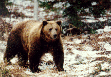 The Interagency Grizzly Bear Committee's (IGBC) Grizzly Bear Recovery Plan
identifies roads as a primary factor in bear survival: "Roads probably pose
the most imminent threat to grizzly bear habitat today" (USFWS 1993).
The Interagency Grizzly Bear Committee's (IGBC) Grizzly Bear Recovery Plan
identifies roads as a primary factor in bear survival: "Roads probably pose
the most imminent threat to grizzly bear habitat today" (USFWS 1993).
Bear mortality occurs both directly and indirectly. Direct causes of death
come from road kill as animals attempt to cross highways or other routes that
carry high speed traffic. Train-bear collisions have been a recurring problem
along the Burlington-Northern tracks on the southern boundary of Glacier
National Park in Montana. Railway accidents have regularly spilled grain on and
around the tracks, which subsequently attracts bears to feed on the grain and
leads to bear deaths. Indirect mortality results from illegal poaching (and,
until the early 1990s, legal hunting in Montana) by people using roads in grizzly
habitat and from federal or state control actions in response to human/bear
conflicts along roads. Even closed road systems may present potentially lethal
conditions for bears. As the Grizzly Bear Recovery Plan notes in Appendix B:
Mortality is the most serious consequence of roads in grizzly
habitat. Research has confirmed that grizzlies experience increased
vulnerability to legal harvest and poaching as a consequence of increased road
access by humans (Schallenberger 1980, Zager 1980, McLellan and Mace 1985, Aune
and Kasworm 1989). McLellan and Mace (1985) found that a disproportionate number
of human-causes grizzly mortalities occurred near roads. In Montana, Dood et al.
(1986) reported that 48% of all known non-hunting mortalities during 1967-1986
occurred within one mile of roads. Aune and Kasworm (1989) reported 63% of known
human-caused grizzly deaths on the east front of the Rocky Mountains occurred
within 1 km of roads, including 10 of 11 known female grizzly bear deaths. Bears
are also killed by vehicle collision, the most direct form of road-related
mortality (Greer 1985, Knight et al. 1986, Palmisciano 1986).
Habitat displacement creates a major impact on grizzly bear recovery that is
widespread and difficult to quantify adequately. Displacement occurs as a result
of grizzly bears' avoidance of areas frequented by humans. Bears tend to avoid
habitat subject to constant or intermittent human use. This behavior has a
serious impact on successful grizzly reproduction and occupation of habitat
areas, especially when open roads occur in high-quality grizzly bear habitat or
areas bears have historically used for den sites. Areas readily accessed by
roads are often valley bottoms and ridge tops, both of which are preferred
grizzly bear forage and travel habitat. Research shows that open road networks
can displace bears and increase mortality (USFWS 1993). Bears can develop such a
strong aversion to vehicle noise, human scent along roads, hunting and shooting
around roads, and other human-related noise, that even after road closures bears
may not return to roaded areas (USFWS 1993). (It is an interesting and relevant
aside that the US Forest Service is the world's most prolific road-builder, with
a road system that now spans more than 375,000 miles.)
Road
Management:
Because of the federal mandate to protect and recover species,
and as a result of the overwhelming evidence that roads and live grizzly bears
are incompatible, the US Forest Service (USFS) and US Fish & Wildlife Service
(USFWS) have established a species recovery strategy under the Endangered Species
Act (ESA) to prevent further depression of grizzly populations in identified
critical habitat (Grizzly Recovery Plan p. 147). This policy delineates the
maximum allowable open and total road density within grizzly recovery areas. It
also determines standards for minimum habitat effectiveness for recovery areas.
The critical measure of both road mileage and effective habitat is the inventory
of USFS-controlled road networks in grizzly habitat, and the yearly road closure
program implemented by the USFS which seeks to comply with the USFWS road density
standards. These programs and data resources are constantly evolving and use
computer technology to maintain detailed information on legal compliance and
habitat quality.
The USFS manages large areas of critical grizzly bear habitat in the Northern
Rockies. These areas are delineated by the Forest Plans for each National
Forest. With input from the IGBC, areas are identified as Bear Management Units
(BMUs), which roughly approximate the size of a female grizzly bear's home range,
including seasonal and elevational distribution of habitats. The home range size,
and subsequently the BMU size, varies according to habitat type. On the Flathead
National Forest, for example, Mace and Manley (1993) found 48 square miles to be
the size of the average home range for nine adult female grizzlies; for drier
habitat types home ranges and BMUs are approximately twice as large and bear
density is lower (IGBC Task Force Report 1994).
The IGBC has recently established its own standards and guidelines for assessing
adequate secure habitat in BMUs. These rules emphasize secure area calculations
derived from open and total road calculations without establishing raw road
density rules. The IGBC also uses buffers or secure area calculations which
recognize a distance from open roads as ineffective habitat for bears. The IGBC
distance is 0.3 miles and some forests, such as the Idaho Panhandle NF, use a
0.25 mile buffer. This results in a discrepancy between USFS and IGBC standards
and guidelines which is currently not reconciled in the field. The IGBC also
calculates secure habitat using a computer modeling technique called "moving
windows analysis." This technique assesses the exact density of roads within
the square mile surrounding any given point in a BMU, by a calculation which
breaks the entire BMU into 50-square-meter units. The resulting data can be
queried to determine the percentage of each BMU with different classes of road
density.
With recovery goals established, recovery depends upon maintaining a minimum
amount of secure habitat or core area for bears within each BMU. Habitat
protection is mandated through Forest Plan Standards and Guidelines and through
IGBC Standards and Guidelines.
Field Methodology:
The Road Scholar Project (RSP) trained field
personnel to evaluate topographic maps obtained from the USFS which depict
up-to-date forest road networks. These maps, provided by the USFS through the
Freedom of Information Act requests or less formal agreements, were taken to USFS
District Offices for targeted forest areas, where they were annotated using
information from recent aerial photographs and satellite imagery. The
annotations illustrate potential road segments that were not included on the USFS
maps, but appear on photographs and images. Once maps were annotated, RSP field
personnel traveled into the field to check all map annotations for accuracy. This
process, undertaken by automobile where roads were legally open to travel, and by
bicycle or foot where roads were legally closed to motor vehicles, involved
physically confirming or refuting the presence of suspected segments through the
use of several criteria: 1) Is there a human-constructed travel corridor in
existence? 2) Is there a corridor available for travel using a standard
four-wheel drive vehicle? and 3) Is there evidence of use on this road corridor?
These criteria were used to assess the possible use and the actual use of the
corridor. Road segments which have a high probability for possible use (i.e.
moderate steepness, adequate width, lack of obstructions) and/or evidence of
actual use were confirmed on the field maps, assigned a unique identification
number, and had a standardized data sheet completed that evaluated key
characteristics. Segments that lack use characteristics (often old logging skid
roads or natural openings not passable by motor vehicles) are kept absent from
inventory maps. Field personnel also assessed whether road segments were
receiving use from off-road vehicles (ORVs), including motorcycles and
four-wheeled All-Terrain Vehicles (ATVs). Evidence of ORV use was noted on road
inventory sheets and distinguished from evidence of standard vehicle travel.
In addition to inventorying road segments, RSP field staff checked USFS road
closure structures for effectiveness. This process involved obtaining recent
road closure orders from USFS District Offices, which depict those existing road
segments legally open to travel by motor vehicle and those roads legally closed
to some or all motor vehicles for all or part of each year. Using this closure
order information, RSP field staff checked all road closures accessible by motor
vehicle in the study areas and completed data sheets, documented by photographs,
of road closure effectiveness. These data sheets recorded the status of road
closures (i.e. whether the closure was open or closed), identified the type of
structure used to secure the road, and recorded evidence of road closure
violations, or agency administrative use, by standard motor vehicles or ORVs.
Figure 2 (43K JPEG)
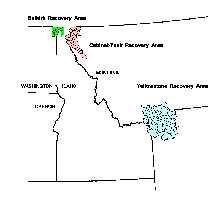 We selected Bear Management Units to inventory from the Yellowstone Grizzly Bear
Recovery Area, the Selkirk Grizzly Bear Recovery Area, and the Cabinet-Yaak
Grizzly Bear Recovery Area (See Figure 2) at the recommendation of local
conservationists and agency personnel. Field work was completed in June, July,
August, and September, 1995.
We selected Bear Management Units to inventory from the Yellowstone Grizzly Bear
Recovery Area, the Selkirk Grizzly Bear Recovery Area, and the Cabinet-Yaak
Grizzly Bear Recovery Area (See Figure 2) at the recommendation of local
conservationists and agency personnel. Field work was completed in June, July,
August, and September, 1995.
GIS Database Creation and Analysis:
Once the field information was
collected and compiled on data sheets, GIS analysts digitized maps and
information from both USFS and RSP road inventories at 1:24,000 scale using PC
ArcInfo. Using a simple code (e.g. for road status, open road = 1, closed road
= 2, etc.) the information gathered during the field work was transferred into
numerical form and processed as an attribute table for the maps. Digital map
information was then paired with the attribute table database. By generating
simple statistical queries, it was possible to calculate total open and closed
road mileage for both RSP and USFS inventories, determine open and total road
density unit-wide, and itemize road closure effectiveness and miles of roads
affected by road closures. By buffering the road segments, we were also able to
determine and depict areas of habitat considered secure within each management
unit.
The line coverages were then exported to workstation ArcInfo, and converted to
grids with a cell size of 50 meters in order to determine the total area of
various road density classes in each unit. To arrive at the total areas for
each of these density classifications in each management unit, we reclassed the
grids, then used the focalsum command in GRID, running the analysis with a
circular search for an area of 1 square mile. This analysis replicates the
"moving window analysis" favored by the IGBC.
We again reclassified the resultant grid to create a grid suitable to be
converted to polygons for simple area queries. Following standards developed by
the IGBC, we used five classes of road density (0-.5; .5-1; 1-2; 2-5; and >5
mi/mi2).
Results:
The majority of road closure devices inventoried by field
staff were either steel gates or earth berms, though other closure devices
included slash piles, post and rail gates, posts and chains, and fallen trees.
Ten and one-half per cent of roads considered to have closure devices according
to the agency inventory had no closure devices at all. Road closure devices were
evaluated for effectiveness within a range of three categories: 1) Closure does
not effectively exclude any vehicle; 2) Closure excludes vehicles over 50"
in width but not ORVs; 3) Closure effectively excludes all vehicles as per USFS
design (regardless of whether or not that road showed signs of having been
accessed through the gate). For the purpose of this inventory, we have listed all
roads which have a gate fully in place and cannot be circumvented by any size
vehicle as effectively "closed" (even if there were signs of access
through the gate) since the closure device is in place and functioning as per
USFS design (see Table 1).
The number in parentheses in Table 1 depicts the number of roads that showed
signs of access through the gate. Table 2 records these same figures as a
percentage of the closure devices inventoried. Be aware that the term
"effective" as it is used in the table simply
means that the device is functioning as it was designed; this does not mean that
the closure device prevents all motorized use, since gates, by design, allow for
motorized use when they are open.
Table 1: Overall Closure Device Effectiveness Ratings
| Closure Effectiveness: | Steel
Gate | Earth Berm | Other | No Device |
| 1-not
effective | 13 | 11 | 2 | 23 | |
| 2-not excluding
ORVs | 61 | 25 | 7 | 0 |
| 3-effective | 61
(56) | 10 | 5 | 0 |
| Total | 135 | 46 | 14 | 23
| | | | |
Table 2: Closure
Effectiveness Percentages By Device
| Closure Effectiveness | Steel Gate | Earth
Berm | Other | No Device |
| 1-not
effective | 9.6% | 23.9% | 14.3% | 100% |
| 2-not excluding ORVs |
45.2% | 54.4% | 50.0% | 0% |
| 3-effective | 45.2% | 21.7% | 35.7% | 0% |
| Total | 100% | 100% | 100% | 100% |
Steel gates with key or combination locks are the most common closure devices.
Yet, there is an inherent problem with the effectiveness of locked gates even
when the gate is, by design and condition, totally functional (i.e., the gate is
fully in place and cannot be circumvented by any size vehicle). These gated roads
are susceptible to use by people who have either a key or combination to the
gate, and who then drive their vehicle past an otherwise effectively closed gate.
This access to an otherwise effectively closed road is either for administrative
use of the road by agency personnel, or accomplished by someone who has acquired
(legally or illegally) the key or combination to that gate. It is important to
note that only five steel gates in the entire inventory showed no signs of having
been accessed through the gate.
RSP field staff also documented the occurrence of "ghost" roads in
their surveys. Ghost roads are roads that do not appear on agency travel plans,
but do exist on the ground. Ghost roads do not appear on these maps since they
are, by definition, roads that were found during ground truthing and not included
in the USFS inventory. Additionally, field staff also documented the absence of
roads that were on agency inventories, but did not exist. The agency inventory
for the Bluegrass BMU, for example, contained 73.78 miles of road that do not
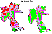
exist on the ground (see Table 3).
Table 3: Miles of Roads Inventoried on each Unit
| BMU | USFS | Ghost | RSP |
| Big Creek | 286.9 | 6.9 | 293.7 |
| Bluegrass | 264.38 | 8.27 | 198.87 |
| Kalispell-Granite | 300.4 | 34.3 | 334.3 |
| Lamar | 70.6 | 14.9 | 85.6 |
| LeClerq | 198.3 | 37.3 | 235.3 |
| Spar | 252.2 | 11.5 | 262.4 |
| Sullivan-Hughes | 213.5 | 18.8 | 239.3 |
Road densities were calculated (Table 4) for open road networks and total road
networks for each management unit. Discrepancies between agency figures and RSP
result from the addition of ghost road mileage to the road density calculations
for the RSP, as well as the absence of closure devices. Restricted roads include
ghost roads and USFS roads with closures that receive clear vehicular use either
through or around the closure device, including gated roads that receive
administrative or illicit use.
Table 4: Road Densities on each Unit (mi/mi2)
| BMU | USFS Open | USFS Total | RSP
Open | RSP Open/Restricted | RSP Total |
| Big
Creek | 0.78 | 2.2 | 0.83 | 2.2 | 2.2 |
| Bluegrass | 1.04 | 2.9 | 0.6 | 2.2 | 2.2
|
| Kalispell-Granite | 1.7 | 2.2 | 2.0 | 2.5 | 2.5
|
| Lamar | 0.15 | 0.15 | 0.18 | 0.18 | 0.18
|
| LeClerq | 1.2 | 1.8 | 1.2 | 2.1 | 2.1
|
| Spar | 0.52 | 2.1 | 0.84 | 2.1 | 2.2
|
| Sullivan-Hughes | 0.61 | 1.7 | 0.91 | 1.9 | 1.9 |
Although there is considerable debate regarding the distance at which roads
adversely affect wildlife habitat (see discussion section), a 0.3 mile buffer
distance is the standard agreed upon by the IGBC and should serve as an accurate
minimum distance within which grizzly bear use of the habitat diminishes
significantly. We created a buffer around open roads for both agency and RSP
inventories to ascertain areas of habitat security in the management units (Table
5).
Table 5: Habitat Security Outside Buffer Areas of Open Roads
| BMU | USFS
Secure Area (mi2) | USFS
%Secure | RSP
Secure Area | RSP
%Secure |
| Big Creek | 75.8 | 57.9% | 28.6 | 21.8%
| | | |
|
| Bluegrass | 60.8 | 67.7% | 28.6 | 31.4%
| | | |
|
| Kalispell-Granite | 59.6 | 44% | 40.3 | 29.7%
| | | |
|
| Lamar | 450.9 | 93.8% | 450.0 | 93.6%
| | | |
|
| LeClerq | 59.3 | 53.4% | 31.6 | 28.4%
| | | |
|
| Spar | 52.7 | 44.5% | 51.3 | 43.4%
| | | |
|
| Sullivan-Hughes | 90.1 | 72.3% | 51.1 | 41.0% | | | |
|
Discussion:
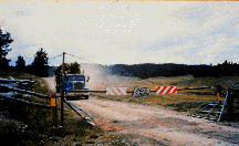
The USFS continues to use locked gates (steel and others)
for road closure devices, despite the fact that these locks and gates are opened
for administrative uses, and may even be opened by private individuals who have
obtained keys or combinations. Such legitimate administrative use or illegal
private use of these "closed "roads impacts a number of wildlife
species sensitive to human presence and activities. (See Figure 3.) It is
misleading and inappropriate to consider these roads truly "closed."
Habitat security is diminished on road segments that remain open to use due to
ineffective or administratively-accessed closures, and the agency's management
should respond to this by either closing roads or restructuring its road
classification system.
Figure 3 (26K JPEG)
 It is worth noting that the USFS' open/closed road classification differs
somewhat from the Interagency Grizzly Bear Committee's (IGBC) classification of
road types, which breaks roads into three categories: open, restricted, and
reclaimed/obliterated. The first and third types are self-explanatory. A
"restricted" road is a road on which motorized vehicle use is excluded
seasonally or yearlong, the road requires a physical obstruction, and motorized
vehicle use is legally prohibited. Under the IGBC's classification,
"motorized use by personnel of resource management agencies is acceptable at
low intensity levels..." and this "includes contractors and permittees
in addition to agency employees." The majority of roads closed by steel
gates on the Forest would come under the IGBC's classification of
"restricted road." (See Figure 4)
It is worth noting that the USFS' open/closed road classification differs
somewhat from the Interagency Grizzly Bear Committee's (IGBC) classification of
road types, which breaks roads into three categories: open, restricted, and
reclaimed/obliterated. The first and third types are self-explanatory. A
"restricted" road is a road on which motorized vehicle use is excluded
seasonally or yearlong, the road requires a physical obstruction, and motorized
vehicle use is legally prohibited. Under the IGBC's classification,
"motorized use by personnel of resource management agencies is acceptable at
low intensity levels..." and this "includes contractors and permittees
in addition to agency employees." The majority of roads closed by steel
gates on the Forest would come under the IGBC's classification of
"restricted road." (See Figure 4)
Figure 4 (73K JPEG)
 The Interagency Grizzly Bear Committee's classification of roads as open,
restricted, and reclaimed/obliterated may help remedy the hazy distinction
between roads that are actually closed versus those that are not-quite-wide-open.
Regardless of which classification the national forests may choose to use in the
future, it is legally and biologically imperative that the forests identify which
roads are receiving occasional use, administrative or otherwise, and which are
simply impossible to travel and can therefore be removed from the open or
restricted road inventory.
The Interagency Grizzly Bear Committee's classification of roads as open,
restricted, and reclaimed/obliterated may help remedy the hazy distinction
between roads that are actually closed versus those that are not-quite-wide-open.
Regardless of which classification the national forests may choose to use in the
future, it is legally and biologically imperative that the forests identify which
roads are receiving occasional use, administrative or otherwise, and which are
simply impossible to travel and can therefore be removed from the open or
restricted road inventory.
All roads considered closed by the USFS should be closed with adequately sized
and placed physical obstructions. These barriers (earth berms, tank traps, large
boulders, etc.) should be placed so that no detour is possible around the
structure. Also, the surface of the road behind the closure should be blocked
(or the roadbed scarified) for the first one quarter mile with slash and logs to
discourage ORV use of the road behind the closure structure. All roads not
included as system roads should be obliterated, recontoured and revegetated.
Roads that the USFS wants to keep open for administrative use can be blocked with
a gate, but should not be considered "closed" roads in the travel plan.
Gated roads should be classified as open or restricted, depending on the level of
use anticipated and actualized. This would require the Forest Service to
seriously assess whether administrative use was important enough to keep roads on
the open road inventory, or decide that roads could be closed, obliterated, and
removed from the travel plan. This would prevent casual use of roads that are
listed closed by USFS personnel, and would also thwart illegal use by the public.
Emergency access can still be assured by the ease of removal of physical
obstructions (with the help of heavy machinery), as evidenced by widespread fire
access through earth berms during the 1994 fire season.
The total road density, which generally is not considered by the USFS for bear
management or habitat security considerations, has biological relevance and
should be noted as well. Mace, et al., found that "avoidance of areas
having a high total road density was evident for some bears, even though roads
were closed to public travel." The same study found that female grizzly
bears favored habitat with lower total road densities, and that bears did not use
lands with a total road density of 6.0 miles/mile2.
Figure 5 (68K JPEG)
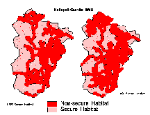 Perhaps the most relevant measure of the
effectiveness of a Forest's efforts to manage roads to minimize their impacts on
wildlife is the size of the area within the wildlife management unit which is
available as secure habitat for wildlife.(See Figure 5.) The US Fish and Wildlife
Service has identified 0.5 mile buffers as an acceptable security
disqualification for grizzly habitat in the Northern Rockies (Lost Silver
Biological Opinion). Further, research in the Cabinet-Yaak ecosystem of
northwestern Montana by Kasworm and Manley in 1988 showed that grizzly bears
avoided roads more than expected within 0.57 miles of a road. We used a 0.3 mile
buffer along each side of a road in an effort to create comparisons that match
with current agency management policy.
Perhaps the most relevant measure of the
effectiveness of a Forest's efforts to manage roads to minimize their impacts on
wildlife is the size of the area within the wildlife management unit which is
available as secure habitat for wildlife.(See Figure 5.) The US Fish and Wildlife
Service has identified 0.5 mile buffers as an acceptable security
disqualification for grizzly habitat in the Northern Rockies (Lost Silver
Biological Opinion). Further, research in the Cabinet-Yaak ecosystem of
northwestern Montana by Kasworm and Manley in 1988 showed that grizzly bears
avoided roads more than expected within 0.57 miles of a road. We used a 0.3 mile
buffer along each side of a road in an effort to create comparisons that match
with current agency management policy.
The inclusion of a "percentage of secure habitat" standard should also
be incorporated as a Forest Plan revisions for species that rely upon roadless
refugia for their survival. This secure habitat percentage, when combined with
road density standards, can ensure to a fuller extent that standards will
translate to adequate security for wildlife populations to survive. The specific
percentage will vary from one species to another, so a percentage should be
adopted that will provide security for the full range of the agency's management
indicator species. The Idaho Panhandle National Forest, for example, uses a 70%
minimum security level to provide for the safety of bears.
Restricted roads need to be carefully monitored to determine if they are
receiving more use than bears and other road-sensitive species can tolerate. If
use exceeds this level, then the agency must enforce closures and other
restrictions to bring the Forest into compliance with its own management
standards.
Studies lend support for considering total road density (rather than just open
road densities) as the more important figure in determining impacts on grizzly
bear habitat, since bears have been shown to avoid roads even after closure. With
this in mind, the RSP and USFS inventories both demonstrate an excessive amount
of land affected by road networks in the management units.
A final important policy measure that will contribute to wildlife security on
these BMUs is a moratorium on all road building unit-wide until road closures,
restrictions, and densities are demonstrated to be in full compliance with Forest
Plan standards and NFMA regulations.
Acknowledgements:
The authors wish to thank Esri--particularly Jack
Dangermon and Charles Convis-- whose donation of ArcInfo and ARCView software
was essential to these analyses. References Cited:
Aune, K. and W.
Kasworm. 1989. Final Report East Front Grizzly Bear Study. Montana Department
of Fish, Wildlife, and Parks. Helena, MT.
Britell, J.D., R.J. Toelker, S.J. Sweeney, and G.M. Koehler. 1989. Native cats
of Washington. Washington Department of Wildlife. Olympia, WA.
Dood, A.R., R.D. Brannon, and R.D. Mace. 1986. Final Programmatic Environmental
Impact Statement: The Grizzly Bear in Northwestern Montana. Montana Department
of Fish, Wildlife, and Parks. Helena, MT.
Greer, K.R. 1985. "Montana Statewide Grizzly Bear Mortalities,
1983-1984." Montana Department of Fish, Wildlife, and
Parks. Bozeman, MT.
Hornocker, M.G. and H.S. Hash. 1981. "Ecology of the wolverine
in northwestern Montana." Canadian Journal of Zoology 59:
1286-1301.
Kasworm, W.F., and T. Manley. 1988. Grizzly bear and black bear ecology in the
Cabinet Mountains of northwest Montana. Montana Department of Fish,
Wildlife, and Parks. Helena, MT.
Knight, R.R., B.M. Blanchard, and D. Mattson. 1986.
"Yellowstone Grizzly Bear Investigations."
Annual Report of the Interagency Grizzly Bear Study Team, 1985. Bozeman, MT.
Lyon, L.J. 1983. "Road density models describing habitat
effectiveness for elk." Journal of Forestry 81: 592-595,
613.
Mace, R.D. et al. 1996 "Relationships among grizzly bears,
roads, and habitat in the Swan Mountains, Montana." Journal of
Applied Ecology, 33.
McLellan, B. and R.D. Mace. 1985. "Behavior of grizzly bears
in response to roads, seismic activity, and people."
British Columbia Minister of the Environment., Fish and Wildlife Branch,
Cranbrook, B.C.
McClellan, B.N., and D.M. Shackleton. 1988. "Grizzly bears and
resource-extraction industries: effects of roads on behavior, habitat use an
d demography." Journal of Applied Ecology, 25: 451-460.
Megahan, W.F. and W.J.Kidd. 1972. "Effects of logging and
logging roads on erosion and sediment deposition from steep
terrain." Journal of Forestry 70 (3): 136-141.
Naney, R. 1991. USDA Forest Service Region One. Lynx, Fisher, and Wolverine
Coordination Meeting.
Noss, Reed. May 1995. "The Ecological Effects of
Roads," Road-Ripper's Handbook.
Palmisciano, D. 1986. Grizzly mortality update. Montana Department of Fish,
Wildlife, and Parks. Bozeman, MT.
Schallenberger, A. 1980. Review of oil and gas exploration impacts on grizzly
bears. Int. Conf. Bear Res. and Manage. 4: 271-276.
USDI. Fish and Wildlife Service. 1993. Grizzly Bear Recovery Plan. Missoula,
MT.
USDI. Fish and Wildlife Service. 1994. Amended Biological Opinion on the Lost
Silver Timber Sale.
Helena, MT.
USDI. Interagency Grizzly Bear Committee. 1994. Task force Report: Grizzly
Bear/Motorized Access Management.
Wisdom, Mike. "Roads, Access, and Wildlife,"
Pacific Northwest Region, USDA Forest Service, (as cited in Natural Resource
News, Winter 1996).
Zager, P.E. 1980. "Grizzly bear habitat
utilization." Pp. 99-132 in C. Jonkel ed. Annual Report No. 5,
Border Grizzly Project. University of Montana, Missoula, MT.
Author
Information:
Timothy Bechtold
The Ecology Center, Inc
1519 Cooper
Street
Missoula, MT 59802
www.wildrockies.org/teci
bechtold@wildrockies.org
David Havlick
Predator Project
Box 6733
Bozeman, MT 59771
predproj@avicom.net
Keith Stockmann
Predator Project
Box 6733
Bozeman, MT 59771
predproj@avicom.net
 The Interagency Grizzly Bear Committee's (IGBC) Grizzly Bear Recovery Plan
identifies roads as a primary factor in bear survival: "Roads probably pose
the most imminent threat to grizzly bear habitat today" (USFWS 1993).
The Interagency Grizzly Bear Committee's (IGBC) Grizzly Bear Recovery Plan
identifies roads as a primary factor in bear survival: "Roads probably pose
the most imminent threat to grizzly bear habitat today" (USFWS 1993).