In order to spot oil wells and draw lease polygons for oil and gas exploration or pipeline management, a fully polygonized and attributed land database is required. The original data were generated on a legacy system of mid 1980s vintage. Land polygons are represented as a database of "spaghetti" type linework.
The WhiteStar Corporation developed a procedure using Esri ArcCAD technology to convert the Texas Railroad Commission linework data of original surveys in Texas to a set of fully polygonized polygon coverages suitable for spatial analysis and display.
The Texas Railroad Commission, the oversight body in charge of Oil and Gas regulations in the state of Texas, has developed over the past decade a Well Location File consisting of oil and gas well locations and Texas land survey lines. These data were derived from the original GLO (Texas Government Land Office) County Patent Survey Maps and Texas Land Title Index and Abstract Supplements. Available in an ASCII file format, the Commission distributes these data in an ASCII file structure on nine-track tape. The original work was performed on a VAX system using proprietary mapping software.
The original data files, when converted from ASCII format to a CAD format, are useful mainly as a backdrop to other data. Capabilities are limited to turning on and off various layers of information to display boundaries and text labels by category. For example, to produce a map of all Texas Block boundaries, one turns on the appropriate set of layers while leaving unrelated data layers turned off. With regard to text labels, these were collected on a 7.5 minute USGS map basis. Consequently, labels on maps plotted at other scales are often inappropriately distributed and sized.
A solution to this problem is to convert the "spaghetti linework" to a series of polygon coverages, and then associate the textual information as attributes to each polygon. This procedure would allow for polygon-based analysis, land parcel area calculations, production of shaded maps, well spotting abilities, etc.
Based upon our research and requirements of oil and gas data users, we developed a set of criteria that had to be met converting the data to polygonal format.
1. Clean up the AutoCAD® drawing to provide closed polygons and non-redundant labels.
2. Attribute each polygon with 19 new attributes.
3. Spot wells given footages from the polygon external lines.
4. Compute footages for those wells having none.
5. Compute acreage
6. Normalize well location descriptions to be consistent with the associated polygon.
7. Establish a hierarchy of polygons.
| Polygon Attribute Name | Description |
| COUNTY | County Name |
| BLOCKNA | Block Name |
| BLOCKNO | Block Number |
| BLOOVNA | Overlap Block Name |
| BLOOVNO | Overlap Block Number |
| SURVNA | Survey Name |
| SURVNO | Survey Number |
| SUROVNA | Overlap Survey Name |
| SUROVNO | Overlap Survey Number |
| ABSNA | Abstract Name |
| ABSNO | Abstract Number |
| ABSOVNA | Overlap Abstract Name |
| ABSOVNO | Overlap Abstract Number |
| SUBDNA | Subdivision Name |
| SUBDNO | Subdivision Number |
| LOTNA | Lot Name |
| LOTNO | Lot Number |
| TRACTNA | Tract Name |
| TRACTNO | Tract Number |
Table 1
To convert the vector data to polygon format, we selected Esri’s ArcCAD® product. We took advantage of our previous expertise with AutoCAD® software to readily load the drawing file and prepare it for polygonization. ArcCAD® lets us use existing in-house AutoLISP® routines to perform workflow optimized tasks such as editing line segments, changing them to an appropriate layer, and sizing and movement of text.
In addition, ArcCAD® introduces critical GIS capabilities into the CAD environment, allowing us to identify overshoots and undershoots in the data and to identify polygon label errors.
1. Using an in-house routine, convert the ASCII file from 9 track delivery media to DXF format.
2. Convert the Drawing file to the appropriate state plane zone.
Normally, we store all of our data in NAD-27 longitude/latitude coordinates. This step is performed to permit sensible selection of values for Fuzzy Tolerances.
3. Consolidate the CAD Layers
Many of the layers take into account CAD considerations which really are not relevant to GIS technology. For example, some layers are named "SMALL_SURVEY_ANNOTATION" and "VERY_SMALL_SURVEY_ANNOTATION". Such nomenclature is an attempt to get around the limitations of CAD technology. We consolidate and simplify the number of layers.
4. Upon consolidation of the CAD layers, the data are arranged by polygon type.. For example, the county boundary and associated text are moved to one layer, the Block boundary and text to another, and other types of polygons on a third.
5. For each layer, clean up the linework. This includes making sure that each "proto-polygon" closes, and that the constituent polylines of the polygon are all on the same layer. Clean, build, noderror (with the dangle option) and laberror are essential ArcCAD commands for cleaning up the linework.
6. Insure that each "proto-polygon" has a single label point. ArcCAD considers AutoCAD text as a suitable type of label point. Therefore, on the county layer, we place the county name. On the block layer we place the block name. On the survey layer we place the survey name, and so forth. Since surveys (and many other polygons) can have both a name and a number, we maintain separate layers, one for the survey name and survey number. This procedure is repeated for 19 separate attribute types (see table 1).
7. Once the polygons and text are laid out, ArcCAD®’s POLYPIN AutoLISP® routine is used to relate each piece of text to its associated polygon.
8. Each subordinate polygon coverage, for example surveys, are "unioned" with its superior polygon coverage, for example Blocks, to create a hierarchy of attributes. For instance, the end user needs to know not only the survey name and survey number of a particular polygon, but also what block it belongs to. We build a hierarchy of County->Block->Survey->Abstract relationships as well as a (usually unrelated) Subdivision->Lot->Tract hierarchy.
9. Text annotation are converted to Annotation themes and exported to .E00 format.
10. Arc theme such as streams, creeks, and roads are exported to .E00 format.
The techniques used to turn the Texas Railroad Commission Well Location File into polygon coverages demonstrate the basic functionality and importance of a GIS system. Using this technology, we were able to meet the database design objectives outlined above and greatly extend the utility of legacy data developed originally in a "spaghetti line" environment for analytical purposes that were not foreseen at the outset of data development. Moreover, conversion of such data provides a cost-effective solution for oil and gas exploration where none existed before.
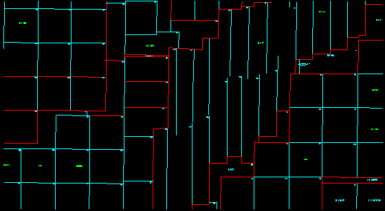
Figures 1 and 2 show below some of the cosmetic changes that occur to the CAD drawing when converting to a Polygon Coverage / Cleaned up CAD drawing. Please note the following:
Figure 1
("Spaghetti Linework")
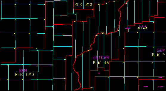
Figure 2
(Polygon Coverages)
Robert C. White, Jr.
President
WhiteStar Corporation
333 W. Hampden Ave, Suite 604
Englewood, CO 80110
Telephone: (303) 781-5182
Fax: (303) 781-5275
Email: rcw@whitestar.com
Louise White Eshelman
Vice President of Cartographic Development
WhiteStar Corporation
333 W. Hampden Ave, Suite 604
Englewood, CO 80110
Telephone (303) 781-5182
Fax: (303) 781-5275
Email: louise@whitestar.com