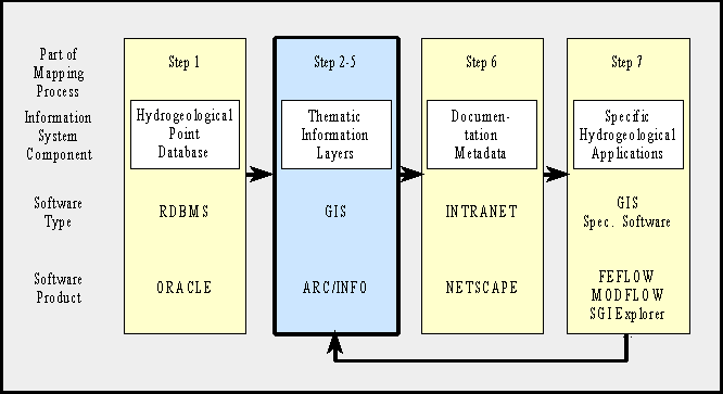
Figure 1: Representation of the 7-step mapping process in the information system architecture
A 7-step hydrogeological mapping process is introduced and described from an organizational and from a technical view. It is illustrated with an application example. The paper focuses on a conceptual model for storing mapping results as thematic information layers in ArcInfo data sets.
The mapping process produces a huge quantity of geodata sets. To create, use and update this data sets in a flexible and comfortable way, digital mapping techniques are applied and information systems are set up. Due to the great variety of data types and scientific requirements for data processing, a lot of different software products are used. Among these are relational database managements system, geographic information systems and a great variety of specific hydrogeological software. This specific software includes statistical and geostatistical techniques, simulation models, 3D visualization, hydraulic and hydrochemical evaluation techniques and graphic applications. As all data are characterized by their location, a GIS is the central component within such a software environment.
In this context, the basic tasks of a GIS are the administration and visualization of spatial data and their attributes, as well as geocoded pre- and postprocessing of data for 3D analysis, simulation and other hydrogeological evaluations. GIS acts as an integration platform and offers the possibility of a consistent, interactive user environment.
The paper focuses on the use of GIS for the hydrogeological mapping and evaluation process at the State Geological Survey and its implementation in the survey's information system infrastructure. A conceptual model for storing spatial hydrogeological data in ArcInfo data sets is described.
| 1 Screening and updating the hydrogeological database (point and spatial data) |
| 2 Visualizing the geological records of boreholes (hydrogeological interpretation) and time series of parameters |
| 3 Building series of cross sections across the study area (vertical projection of 3D problem) |
| 4 Interpreting and interpolating hydrogeological borders in the study area (horizontal projection of 3D problem) |
| 5 Deriving hydrogeological bodies from borders; Assigning hydraulic and hydrochemical parameters to bodies; Defining boundary conditions for fluid flux into and out of bodies |
| 6 Documentation and metadata administration in an information system |
| 7 Cartography, 3D visualization and further evaluations, e.g. simulation models |
| MAP: Hydrogeological map of the Rhinegraben aquifer system |
Phreatic groundwater surface
|
Bottom of phreatic aquifer
|
Permeability of phreatic aquifer
|
Step 1:
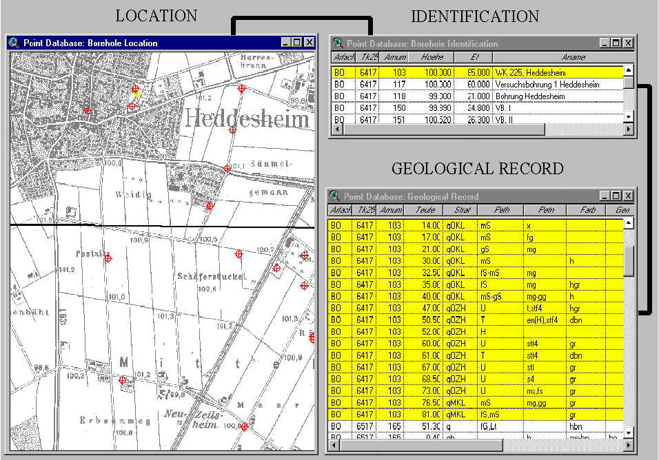
The survey's hydrogeological point database (ADB)
contains all data, that refer to point objects. These are base data (identification
of the point, etc.) borehole descriptions (filter screnes, geological records, etc.) and
(hydro-)chemical, (geo-)physical and isotopical measurement data. The ArcView
screendump shows boreholes and wells of the hydrogeological point database
around a public water supply. The tables display basic information about
borehole identification and a subset of the geological information stored with
these points.
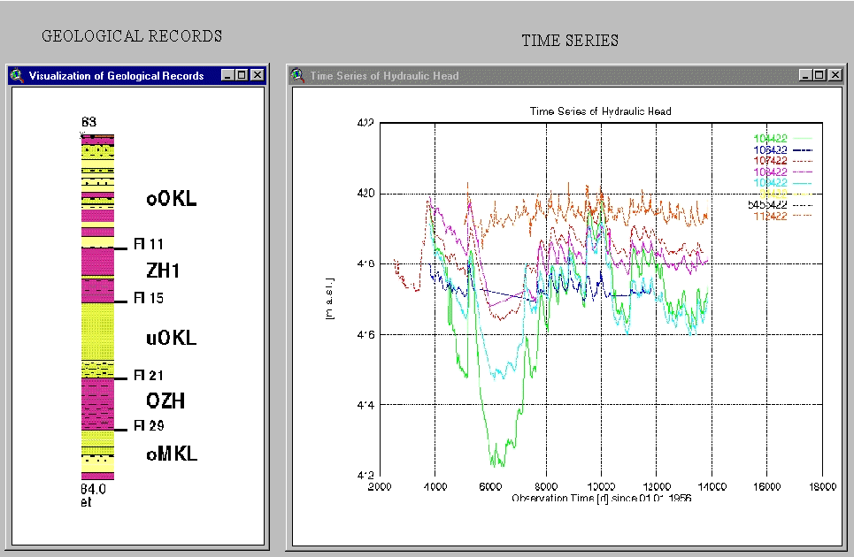
Step 2:
Data from the ORACLE point database are evaluated and
visualized by a variety of software packages. ArcView is a platform, that allows to
integrate these results in a consistent and interactive user environment.
The ArcView screendump shows results from the geological profiling software
and time series from GNUPLOT.
The geological record in the left window show separate geological layers in different colors. The hydrogeological interpretation of these layers is shown by text and markers on the right side of the profile. The markers show the borders of hydrogeological units. The text is an abbreviation for the hydrogeological border, (Fl11, Fl15, etc.) or the hydrogeological body (ooOKL, ZH1, etc.). The hydrogeological interpretation is used for vertical (step 3) and horizontal (step 4) interpolation of hydrogeological bodies.
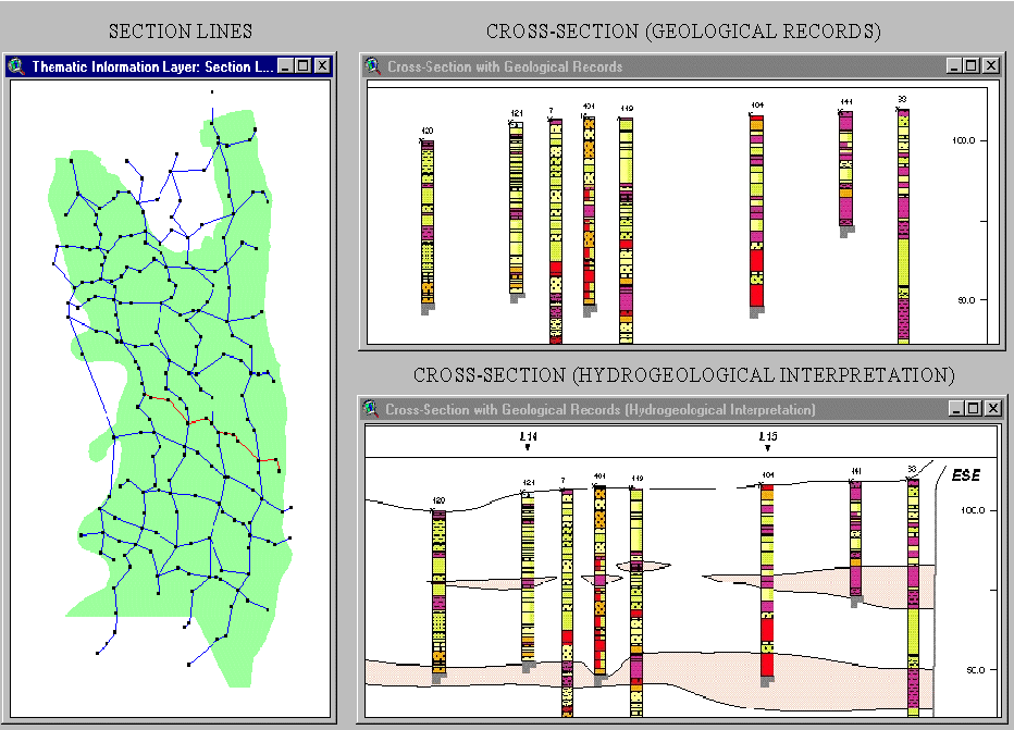
Step 3:
Vertical projection of the hydrogeological bodies is applied by interpreting and
interpolating profile data. The left window of the ArcView screendump show the section
lines of the study area. The upper right window show the uninterpreted visualization of
a cross-section. The lower right window shows interpretation results and the interpolation
of hydrogeological bodies in vertical projections. The cross-sections are stored as
ADOBE ILLUSTRATOR graphic files.
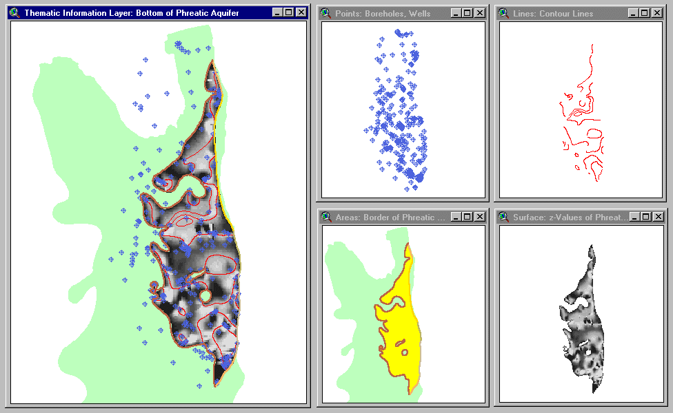
Step 4:
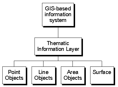
The ArcView screendump shows the horizontal projection of the bottom of the phreatic aquifer.
It is stored as thematic information layer, which consists of point objects/primary data
(wells, boreholes), line data (contour lines), area data (study area, border of phreatic
aquifer in the study are) and a surface grid. All components of the thematic information
layer are shown in the left window. The other windows show each individual component in
a separate window.
The hydrogeological borders are used to define hydrogeological bodies. A critical point in the interpolation process is the exact match of the individual layers of a body, especially when using a 2D data model.
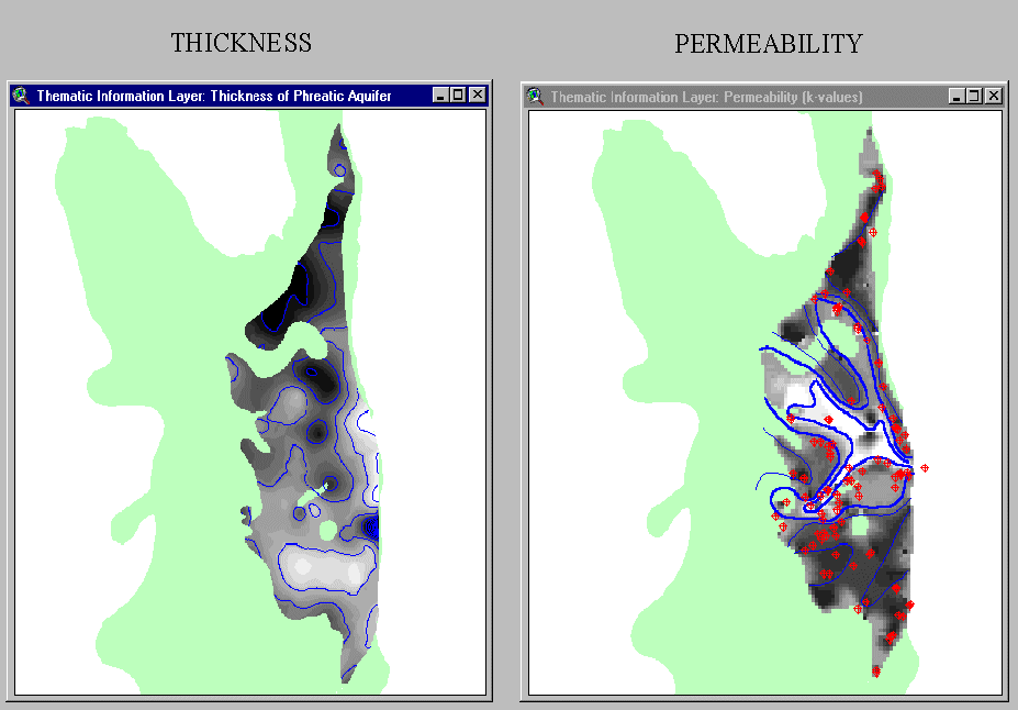
Step 5:
The ArcView screendump shows example of hydrogeological evaluations. Thickness is calculated
by grid overlay. The permeability layer is created by evaluating pumping test data and
assigning them to hydrogeological bodies.
Step 6:
The results of the mapping process are documented and stored in an information system.
The INTRANET application for searching and visualizing the mapping results distinguish between
basic geographic information (e.g. topography, administrative borders), state-wide mapping
projects (e.g. geological base maps) and project data (specific evaluations).
The screendump shows the user interface for searching the database with the NETSCAPE
browser.
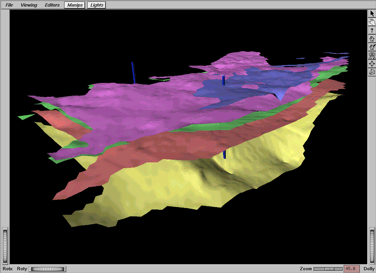
Step 7:
Mapping results are further evaluated by groundwater models, 3D visualization software and
other software packages. The screendump shows a visualization of the basic hydrogeological
layers in the study area as a 3D animation with SGI Explorer.
The information system provides fast and comfortable tools for querying and screening geodata and their attributes. Different hydrogeological problems and tasks are solved by applying scientific methods within the GIS environment. It is achieved in a very economic way.