*Bisi Lee, HakGi Sohn, JongRae Park, and Byung-Gon Chun
**ChangHahk Hahm
Intelligent Transportation System using SDE
Abstract - In this paper, we consider the application of Intelligent Transportation System using SDE
constructed in Road Traffic Safety Association(RTSA) project. We describe the overall architecture of the System and
investigate the GIS part of the system in detail. Specially, we divide the GIS part into three main
subsystems:client, server, server transfer system, and explain the architectures and implementations of them.
The implemented system shows very efficient, fast, scalable, and available features in handling spatial and aspatial
data in Intelligent Transportation System environment. Therefore our proposed system using SDE can construct very powerful Intelligent Transportation System by managing geographic and transportation data efficiently.
I. Introduction
In recent years, Intelligent Transportation System(ITS) has been gaining interests to support more efficient
transportation since the road capacity is relatively scarce. Main application area of the Geographic Information System(GIS) was ITS, Urban Information System(UIS), AM/FM, environmental application, military application, etc,
and is also gaining popularities in the other Information System such as Management Information System(MIS).
ITS handles the road data that are composed of links and nodes, so the spatial handling of data is important in
ITS. GIS in ITS should support efficient and fast handling of large spatial data in the networked environment
for traffic status monitoring, incident information query, optimal path finding, etc.
Spatial Database Engine(SDE) manipulates spatial data of large database in the network very effciently and fast.
So we adopted SDE as the server in this project, and develop operating clients for PC using novel local grid caching
and clients for managing server in Unix environment, and adopted GIS Data server as the middleware to support
many concurrent users with a small response time in Internet, PC communication, and Fax services. We
describe the architecture and implementation of our system, discusses the performance of the system, and
introduces future directions of the system.
The paper is organized as follows. In Section II, we describe the plan of the project. Then, we explain overall
system architecture in Section III, and the GIS part of system architecture in Section IV. Specially, we describe GIS
system in detail as client system, server system, server transfer system, internet application.
II. The Plan of the Project
The ITS project in Road Traffic Safety Association(RTSA) is focusing on integrated traffic information monitoring and
service system in South Korea. Its major targets are the construction of traffic information service center, integration
of the traffic information in real time, integral traffic information guide, optimal path finding, travel time guide, car navigation
support, etc. In Table 1, the detailed plans of this project are shown according to the step of the project.
Table 1. The plan of the ITS project in RTSA
|
Plan |
Service |
| 1st step(Year 1995-1996) |
Information service center and foundation facility construction |
Traffic status information service in Seoul |
| 2nd step(Year 1997-1998) |
Travel time guide and automatic car navigation system |
Optimal path guide, GPS, car navigation |
| 3rd step(Year 1999-2000) |
Integrated traffic information system |
Integrated traffic information guide in South Korea |
III. Overall System
The overall architecture of the ITS system in RTSA project is depicted in Fig. 1. The ITS system is composed of six subsystems,
that is, integrated information processing system, traffic information collection system, general traffic information system,
traffic information service system, image management system, geographic information system.
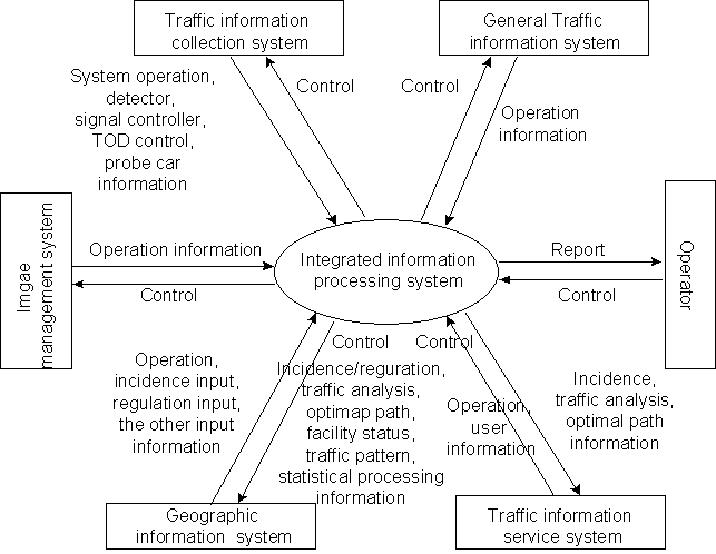
Fig. 1. The overall architecture of the ITS system
Integrated information processing system organizes the systems related with collection, analysis, and transfer, and produces
reliable traffic information. To present traffic status information to users, it mines the refined data from the raw traffic data, and
processes and analyzes the data in real time. Additionally integrated information processing system manages all subsystems, and support
fault tolerances in H/W, S/W, and N/W. The main functions of this system are system status management, traffic information
analyses, statistical analyses, database and file management, etc.
Traffic information collection system collects every qualitative and quantitative real time traffic data and static data that is
necessary to manage and maintain the real time data. Traffic information collection system is classified according to the
related region, the characteristics of the traffic data, the methods of the collection, and the information type. For example,
according to the characteristics of the traffic data, we classify into three categories. The first is the point status data collection by the
detector and signal controller. The second is the section status data collection by the report, CCTV monitoring, and probe car.
And the last is the region status data collection by the weather information and special incidence report, etc.
General traffic information system manipulates the static data related with the driver and the traffic accident. This system
connects to the system in the outer agencies to get the data, and it supplies the data to the traffic information service system.
Traffic information service system processes all collected information from the integrated information system and general traffic
information system integrally, and presents the real time traffic status information and the static information to users by
the internet, PC communication, and FAX service. It supports various services adaptively according to the special user
requirements.
Image management system receives the CCTV signal, generates the static and motion image files from the CCTV signal, and manages the them. The produced image files are used in the integrated information processing system and traffic information
service system. It also handles the main display of the traffic status monitoring system in the traffic information center.
Geographic information system performs the traffic information input, traffic information
query, map and traffic information display, map and transportation information offer to the traffic information service system, and working with the integrated information processing system to find the optimal path considering real time traffic status.
GIS system is very closely related with the other systems, and performs the major input/output, presentation, search, and many other functions related with the spatial and aspatial data in this ITS system.
IV. GIS System
GIS system is composed of client system, server system, server transfer system. Fig.2 shows the overall GIS system and
related ITS subsystem. As manifested in Fig. 2., GIS system has close relationships with integrated information processing system
and traffic information service system.
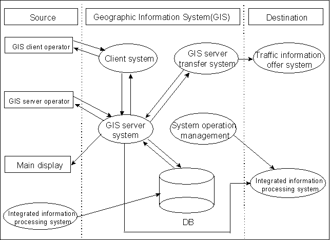
Fig. 2. GIS system architecture
In the GIS system, we adopted two tier architecture for operating and managing clients and servers, and three tier architecture
to interface with internet, PC communication, and FAX by adopting GIS Data server as the middle tier. Major targets of the operating and managing clients are offering convenient and powerful functions to operators and managers to handle input, search, and monitoring of the traffic information. So we implemented very useful and diverse functions in these systems with the very powerful SDE to manage the spatial data in a transparent manner with the other information in Oracle RDBMS. With two tier architecture, we can employ plentiful SDE C client API by wrapping it as our more useful class library, and get good performances by adding sophisticated features such as local grid caching. But in case of the services in internet, PC communication, and FAX, the concurrent users that require services are large, so we have to adopt three tier architecture to support very high volume transactions related with traffic and geographic information. The overall GIS system was designed and implemented efficiently in the ITS system. In the following, we describe client system, server system, server transfer system, internet service architecture
in detail.
4.1 Client system
Operating client handles many jobs such as map display, region search, traffic information input, information query, information search, graphical editing, GPS data display, optimal path display, print, etc. It is developed by using SDE client C API and
Visual C++ 4.2 and operates in Windows 95. We designed and implemented SDE client C++ class library to make the development of the application easy
and the developed codes reusable. Basically we designed and implemented the class Display, View, Theme, Dataset, Layer, Envelope, Feature, Annotation, Symbol, ShapeSymbol, ClassSymbol, LabelSymbol, Attributeset, Column, ColumnValue, GridBuffer by wrapping proper SDE C API, and further extended
and added the other classes related with traffic information processing, graphical editing, and object serialization. One of the most
powerful and efficient mechanism we added are local grid caching in the client side to avoid retrieving data retrieved once before.
Grid indexing mechanism in the client side is same as SDE. It is very efficient to display the spatial data and related attribute data very fast by eliminating network roundtrip delay and to handle large set of spatial data in local client. The client has to perform many things together,
so we adopted thread concepts, and operating client has 4 threads for manipulating various data and display in a consistent manner.
The GUI design of operating clients are also sophiscated for operators to use efficiently and adopted many intelligent features to approach the wanted information diversely and directly.
Fig.3 shows the main operating client screen of the GIS client system of the ITS. In the figure various functions of the operating client are shown. For example,
it shows the labeling, symboling, legend, small map screen for moving to a region, large map screen for major display, identify results, etc.
Fig. 4. shows the operating client screen when user request to input the current status data. It's one of important forms among
almost one hundred forms for this client. When the user input the traffic status in this form, the database is updated and the current traffic status is serviced in internet, PC
communication, and FAX.
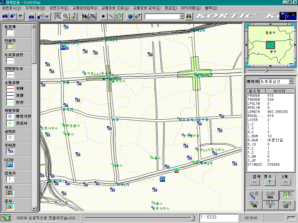
Fig. 3. Main operating client screen
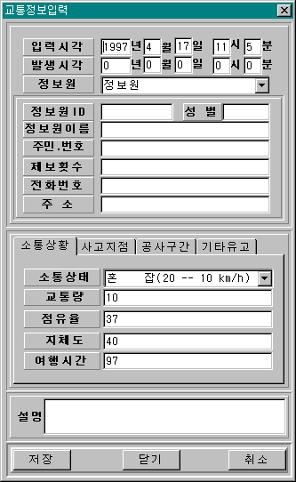
Fig. 4. Operating client screen for the input of the traffic status
The GIS client for managing servers is responsible for managing server and displaying the map to the main display system of the traffic information center.
Main tasks are starting the GIS Data server and SDE, shutdowning them, monitoring them, and manipulating the display of the map in the main
traffic status display. It is developed by the Unix C and Tcl/Tk, and operates in the HP workstation named GIS server in the GIS system configuration.
Its main features are many dynamic and fancy display of the traffic status information such as animated zoom and pan.
4.2 Server system
GIS server system consists of SDE Version 2.1.1 and Oracle RDBMS Version 7.3.2. SDE manages the geographic data in overall system. SDE is very powerful engine to manipulate spatial data. Because it performs the spatial searching and spatial analyses very fast, it is fit to this project. The main concern of the server system is the good database design. We carefully designed the SDE dataset for a long time, because it is strongly related with the performance of the overall system directly. So we discuss the schema of the SDE dataset in Table 2. SDE layers are classified mainly into static and dynamic layers. Almost layers are static. Some layers
such as incidence layers are updated very frequently, so they are dynamic. Dynamic layers are handled carefully not to degrade
the performance. The major layers are the centerline of the road that is network type in SDE and the outline of the road in three levels. We adopted three levels of the road to handle the road efficiently according to the scale. There are also
many point type layers to explain the general facilities and facilities related with traffic.
Table 2. The database schema in the GIS system
| Layer name |
| Administration restrict |
| Water line |
| Centerline of the road(GL-1) |
| Centerline of the road(GL-2) |
| Centerline of the road(GL-3) |
| Outline of the road(GL-1) |
| Outline of the road(GL-2) |
| Outline of the road(GL-3) |
| Traffic safety facility |
| Facility related with traffic |
| Public agency |
| Resort |
| General facility I |
| General facility II |
| Railway/Subway |
| The rest geographic facility |
| Incidence(Construction, Accident, Event, Etc.) |
| Geographic facility related with traffic |
4.3 Server transfer system
Server transfer system connects the outer clients from internet, PC communication, and FAX with the GIS server system.
It consists of the GIS Data server and agents that perform special functions. GIS Data server is the transaction processing monitor. GIS Data server queues the requests of the various kind of clients and processes the required transaction of the client. When it communicates with clients and agent servers it uses the RPC mechanism. The main
functions of the GIS Data server are handling transactions with agent servers and managing agent servers.
Agent servers are always running, and do actual jobs that clients request. We used and implemented
SDE search agent, report agent, mapper agent, parser agent, xfer agent, routing agent, etc. Each agent perfoms
special functions that clients require. SDE search agent performs spatial searching operation with SDE. Report
agent queries and retrieves the data from Oracle directly. Mapper agent retrieves the vector data from SDE and makes
the image(e.g. gif image) in real time. Parser agent parses query strings into the appropriate tokens that the other
agents can interpret. Xfer agent transfers the data into a client. Routing agent finds the optimal path by considering
the current traffic status information and the detailed road information. GIS Data server can handle many concurrent
clients fast and efficiently, so it serves the geographic and transportation data in internet, PC communication, and FAX
successfully.
4.4 Internet
In this project, internet is the major focus to deliver the information to end users. So we describe the overall service
architecture of the internet in this subsection. To support interactive application in web, we chose java applet among java applet and active X control because java is more suitable and portable in internet. Web server communicates with the outer applications by the common gateway interface(CGI) program. The processing steps in Internet are as follows. Java client requests services to the web
server, and the request is transferred to the CGI program. Then CGI program sends the query string to the GIS Data server via RPC. GIS Data server handles the transaction with the appropriate agent servers, sends back the result to the CGI program, and then the result is transferred back to the Java applet in web browser. We implemented the zoom, pan, identify, search, special information
listing, optimal path finding in the internet service. It's very interactive and friendly to users, and shows good performances.
Fig. 5. shows the screen of the internet application. It shows the current traffic status, and in the side frame the parking
information is shown. It has various novel features to get the traffic information interactively in web. We made the
custom java class to support the GIS service of the ITS in web.
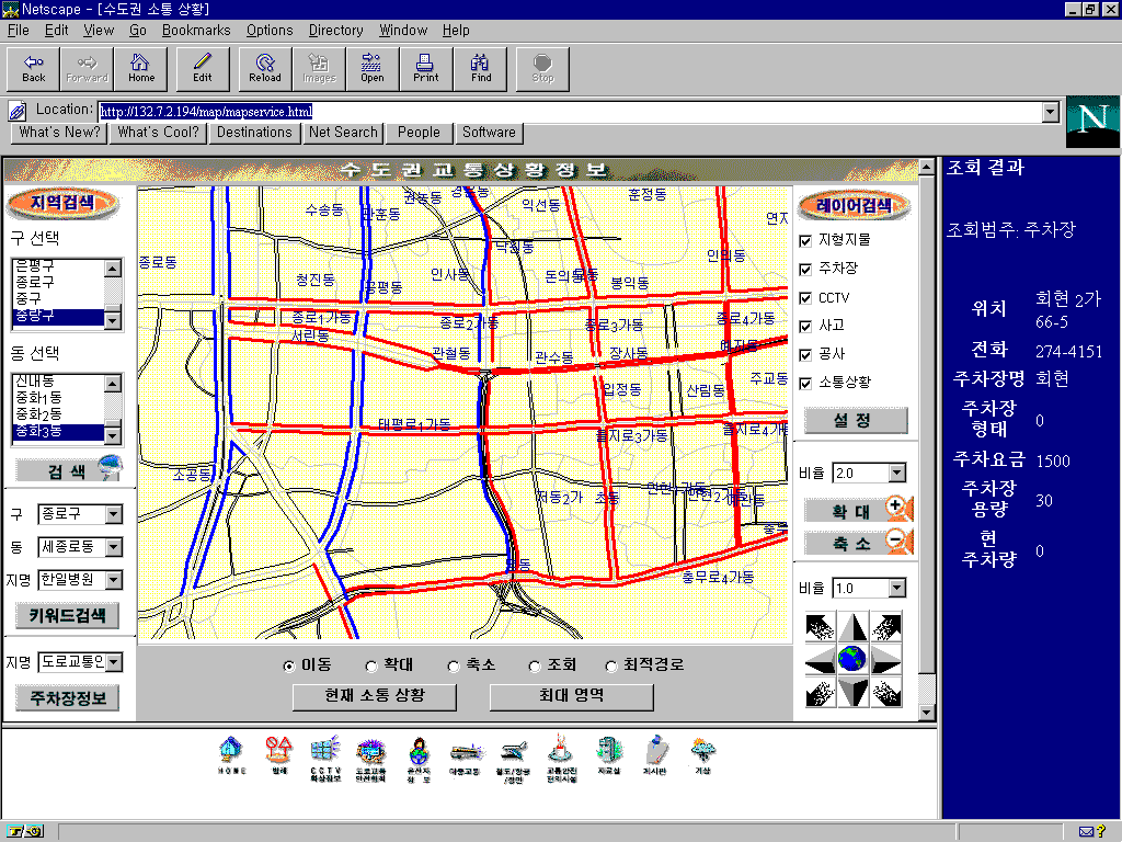
Fig. 5. Internet application screen
V. Conclusion
In this paper, we described the ITS system using SDE. At first, we explained the overall system architecture. Then we investigated the GIS part of the system in detail. In our server system, SDE is open, embeddable, object-based, networked technology, and is powerful, efficient, and fast to handle the geographic and transportation data. So
SDE is very suitable to the ITS system in a large region. In client system, we described the SDE client class library and local grid caching.
The former enhances the reusablility of the client code, and the latter reduces the access time greatly. Both designs
are very helpful in the ITS system and the other applications, and we are planning to improve the class library by adding more features such as local database access. In server transfer system, we adopted GIS Data server to handle
high volume transactions. It is suitable to meet requirements of the GIS service in the ITS system. But compared to the
commercial middleware such as Tuxedo, it does not have dynamic load balancing, transaction priority control, more
transparent and effiecient API to communicate, etc. The GIS capabilities of the GIS Data server and the transaction processing capabilities of the common middleware must be integrated into one to meet various GIS applications.
Further researches are required in the middle tier in the GIS system to support GIS services more efficiently in various
environments.
*Bisi Lee, HakGi Sohn, JongRae Park, and Byung-Gon Chun
System Development Team
CADLAND, INC.
Songnam Bldg., 3rd Floor 1358-6,
Seocho 2-dong, Seocho-gu, Seoul, Korea
Tel:+82-2-3473-4888
Fax:+82-2-3474-2090
E-mail:cadland@inet.co.kr
**ChangHahk Hahm
Department of Geoinfomatics,
Inha Technical Junior College,
253, Yonghyun-dong, Nam-gu, Inchon, Korea
Tel:+82-32-870-2241
Fax:+82-32-868-3408