Initial Analyses of Ironwood Distributions
Relative to Environmental Variables
(Elevation, Slope, Aspect, Geology, Soils and Insolation)
Distributions with Respect to A Single Variable
Ironwood distributions from the original Henriksen map were analyzed in the GIS to
establish an initial characterization of this taxon's distribution relative to
selected single environmental variables. These analyses are presented in the following graphs:
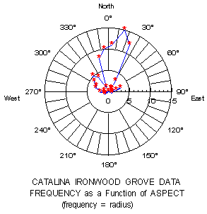
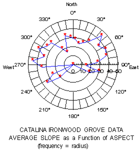
The frequency distribution of ironwood groves relative to slope aspect (in degrees).
Note that on Catalina, the ironwood groves appear to prefer the more mesic
(moist) north- and northeast-facing slopes. This is consistent with their
status as relictual endemics from a period of wetter climate.
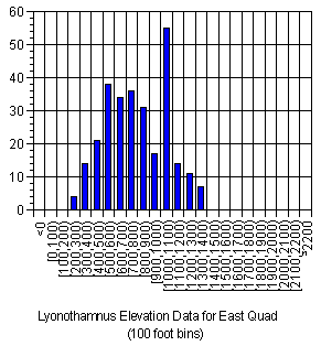
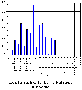
The frequency distribution of ironwood groves relative to elevation (in feet)
for two different geographic regions of the island (USGS East and North Quads).
Note that distribution tends to peak at elevations between 500 and 1,100 feet.
Distributions with Respect to Two Variables
Using the analyses referred to in the methods section, the average value of one environmental
variable can be determined relative to a second variable to determine if ironwood
distribution might be a function of both variables acting together. The following graphs
illustrate the results of such an analysis:
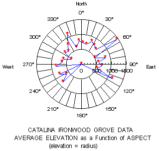
The graph above shows the average elevation (in feet) as a function of aspect
(in degrees) for the ironwood groves in the initial analysis. Note that average
elevation appears to be higher on the generally moister east-facing slopes
The graph above shows the average slope (in degrees) as a function of aspect
(in degrees) for the ironwood groves in the initial analysis. Note that average slope
tends to be steeper on the drier west-facing hillsides, suggesting that ironwoods
located there may be in regions of steeper slope that affords greater shading
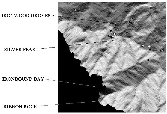
Solved: The Silver Peak Ironwood Grove Mystery
The Conservancy's GIS may have solved a mystery regarding the presence of several ironwood
groves near Silver Peak on the West End of the island. In the field these groves appear to be
in a site relatively exposed to drying afternoon sunlight, and their presence here is an
anomaly.
By viewing the location of the Silver Peak groves relative to fall season surface insolation,
underlying geology and soils, it can be seen that these trees are located in a unique microhabitat
for this exposed, upper elevation site. Surface insolation during the driest period of the year,
early fall, is lower near the groves than in the surrounding areas. Both the geologic rock type and
soils in the immediate vicinity of the grove are different from the surrounding area,
suggesting that soil composition may permit greater water retention.
The location of the Silver Peak ironwood groves (+) against the fall season
surface insolation model in the Conservancy's GIS. Regions of lighter grey indicate
greater surface insolation. Note that the trees are located in a site that receives
less surface insolation during this dry period.
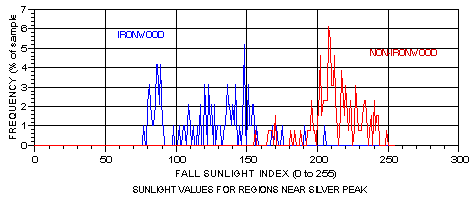
The graph above depicts the same observation as in the image above. The blue line
represents the frequency of insolation values in locations occupied by the Silver Peak
ironwoods, while the red line represents adjacent areas not occupied by ironwoods.
The range of ironwood distribution falls within a lower insolation range than the
surrounding terrain
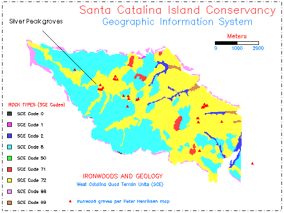
The image above depicts the distribution of these same ironwood trees
relative to the underlying geologic parent material. Note that the Silver
Peak ironwoods are found in a microhabitat defined by a tongue of different
rock (yellow)
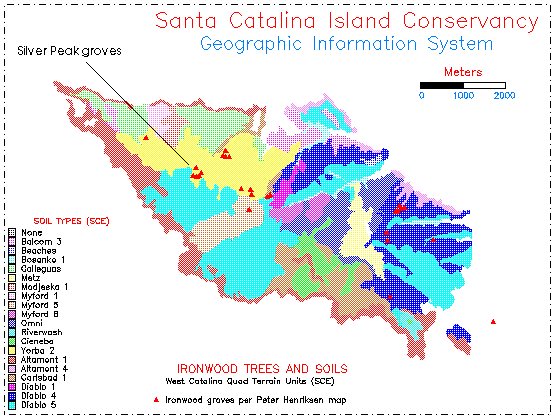
The image above depicts the distribution of the Silver Peak ironwood trees
relative to the surface soils type. Note that these ironwoods are found in a
microhabitat defined by a tongue of different soil (also yellow)
The Silver Peak groves were also in relatively poor condition several years ago, suggesting they
were in a marginal habitat or subjected to grazing by animals such as feral goats. Following the
removal of goats from the island's West End, the trees in this grove have improved their
condition substantially and are showing vegetative reproduction in the form of basal sprouting.
 Return to main text