ABSTRACT: In November 1994, voters in Oregon passed two measures that resulted in the need to build a number of new correctional facilities. The Oregon Department of Corrections (ODOC) was tasked by the legislature to support the newly created Oregon Prison Siting Authority in developing and presenting a list of suitable site locations for review. GIS was identified as a potential source of valuable analysis capability in the siting process. Working together, ODOC and the State Service Center for GIS (SSCGIS) developed a list of siting criteria and identified preliminary GIS analysis needs for the siting process. The SSCGIS then proceeded to provide GIS analysis and output production services, (using ArcInfo and ArcView 3.0), that helped ODOC identify suitable locations for siting new correctional facilities and present the findings to the Governor and the people of Oregon. This paper describes the coordination, data, analysis and output product requirements involved in providing GIS analysis capabilities to the correctional facility siting process.
In response to increasing crime rates and a perceived decrease in the level of safety in their communities, voters in Oregon passed two measures in 1994 that required mandatory sentencing guidelines and an increase in available prison space. The state determined that as a result of the passage of these two measures, approximately 10,000 new prisoners would be added to the already crowded Oregon prison system over the next decade. To absorb the inflow of new prisoners, it was determined that, in addition to expanding the size of some existing facilities, seven new minimum and medium security correctional institutions would need to be constructed by the year 2005. This recommendation was forwarded to the Governor who, with legislative approval, then tasked ODOC with identifying seven sites within the state that would be suitable for the construction of these new facilities.
ODOC and the Siting Authority were given one year to complete the site
selection process and present a list of suitable locations for review.
The first priority was to identify the
siting criteria that would be used in the initial phase of analysis.
Once the process of identifying the basic criteria
was complete, ODOC needed a way to identify those areas in the
state that met these identified siting criteria. At this point,
SSCGIS was contacted and asked to help identify the feasibility
of performing GIS analysis to support the prison siting team.
SSCGIS ran a search through Esri to determine
if GIS had been used in other states during prison site selection
efforts. The search came of negative. Through discussions with
ODOC, SSCGIS determined that the majority of identified
siting criteria contained a geographic component and could be
effectively analyzed using a GIS. SSCGIS proceeded to perform
essential GIS support services through the duration of the siting
process and provide ODOC with information and output products that
were instrumental in developing the final list of suitable sites.
The Site Selection Process - Initial
Screening
Using the initial siting criteria identified by ODOC, the SSCGIS
developed a GIS screening process that incorporated a wide variety
of geographically linked features to identify general areas in
the state that would be potentially suitable for a new correctional
facility. Because of difficulty obtaining some necessary datasets
within the necessary timeframes, the number of criteria for the initial
screening was reduced to include ten key criteria (Table 1). In order
for specific areas to be considered for more intensive, site-specific analysis,
they needed to meet all identified criteria.
Data Development
As mentioned above, the first step in the project was identifying the availability
and quality of all necessary data. Much of the data was available in the
existing SSCGIS database. These layers included: Hospital and communtiy college locations (Oregon GNIS),
generalized zoning of Oregon, and Federal ownership. We also obtained a Halocene (active) earthquake
coverage from USGS in Denver. We developed a slope coverage
from an available Digital Elevation Model (DEM) using the ArcInfo
Grid module. To identify areas within 30 miles of 30,000+ people,
SSCGIS took ArcInfo coverage containing 1990 Census block data and
converted it into an Arc Lattice. A population value was calculated for
each cell based on the associated Census block value/# of cells within each respective block.
The lattice was then converted back into a polygon
coverage using the derived values as the dissolve item.
Analysis
The screening process was fairly simple. Each feature was buffered by the appropriate
distance (if necessary) and then given a value describing whether or not
the identified criteria were met. We then overlayed each of the individual
data sets to create a coverage containing suitable and non-suitable
areas for each criteria. We then reselected the data to determine
those polygons that met all site selection criteria and added
a value indicating this into the feature attribute table. The final site selection criteria
was the determination of area. Polygons that met all identified
criteria were dissolved. A reselect was then performed to determine those
sites that were greater than 200 acres. This produced the final
coverage used to display sites within the state that
met all initial siting criteria.
Output
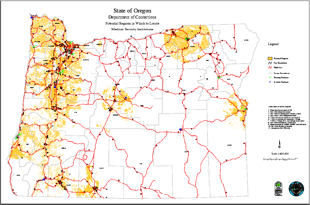
A statewide map displaying the results of the screening analysis
was then developed for use during initial planning meetings and
for discussions with various counties (Figure 1). As certain areas were
identified by ODOC as being most suitable for further analysis
and review, smaller areas of the screening map were produced and
taken to various counties for use in locating specific taxlots
that would require more extensive review.
Figure 1: Results of
Screening Process
Site Specific Analysis
Using the map developed during the screening process, ODOC was
able to narrow the area in which it would conduct a more intensive
search for specific sites. Through a rigorous research and review
process involving numerous meetings with various local governments,
ODOC identified a list of approximately 25 sites that appeared
to meet the initial requirement and that would need additional
research. The SSCGIS was then asked to provide site specific
GIS analysis and output products for each of these sites through
the remainder of the initial site selection process. Once again,
ODOC identified certain features that would preclude development
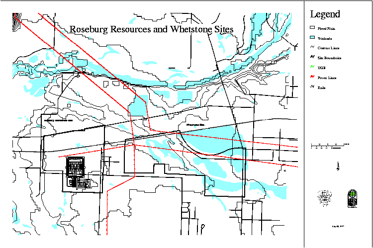
of a correctional facility. Additional criteria included: Outside
FEMA flood zones, outsite identified wetlands, and outside lands zoned "Exclusive Farm Use"
Each potential site was mapped and
analyzed with respect to these and other features (Figure 2). This process
resulted in the further screening of the remaining suitable areas.
At this point in the process, specific sites were identified as
meeting preliminary siting requirements and public meetings were
scheduled.
Once all analysis was complete, the Siting Authority presented to the Governor,
a list of 7 sites that were found to be suitable for siting new
correctional facilities. From this list, four sites were accepted
and three sites were returned for further analysis. In addition,
a number of newly nominated sites were added to the list of sites
needing further study.
Figure 2: Example of Site
Specific Map Product
Ongoing Functions
SSCGIS continues to provide GIS analysis and report/map development
functions to ODOC in support of this on-going effort. ODOC is now in the final stages of
reviewing and selecting
the last three sites that will be presented to the Governor by the Siting Authority.
Due to the controversy surrounding some of the potential sites,
several proposed bills related to prison siting are currently
being reviewed by legislative committees. SSCGIS is supplying
ODOC with detailed maps and additional analysis to assist in the
formulation of a response on the effects the proposed legislation. In some cases, proposed
legislation would, if implemented, effectively
remove the vast majority of formerly suitable sites from consideration. The SSCGIS is
producing maps that show the legislature the true impact of any proposed legislation.
What We Learned
The correctional facility site selection process is a complex,
controversial, and ever-changing operation. One of the key requirements
for successful implementation of GIS analysis and support during
the process is identifying a person within the siting agency that
understands the benefits of GIS and is committed to using GIS
as a tool for analysis. Another requirement is the ability to
allocate resources and work quickly to produce accurate analysis
results and output products. Many of the analysis and output
product requests made by ODOC were driven by the need to respond
to a rising controversy or to defend a decision before a legislative
subcommittee or at a public meeting. Finally, this process requires
the ability to be flexible and to produce defensible products
in the face of ever-changing priorities, mandates and requests.
Since the entire site selection process is extremely controversial
and open to public review, GIS services over the course of the
project often take unexpected twists on their way to completion.
Being prepared to deal with any potential change or last-minute
request is essential.
Conclusion
Using GIS technology, SSCGIS was able to provide information that
enabled ODOC and the Siting Authority to make informed decisions about the ability of various
locations to meet identified siting criteria. GIS provided accurate,
objective, and documentable analysis during an often times
contentious debate over where to site future correctional facilities.
GIS also provided the foundation for developing a wide variety
of map products used in the many public, legislative and planning
meetings required during this process. The details of this paper
are specific to the correctional facility site selection process
in Oregon but are likely to have many similarities to other correctional facility
siting programs. The process may proceed differently depending on the
state involved, but we believe that GIS technology can and will play a
valuable role in providing the essential analysis required
for the successful completion of future correctional facility site selection efforts.
Acknowledgements
The authors would like to acknowledge the efforts and input of the following
people:
ZaDean Auyer - ODOC's site selection lead. It was ZaDean's initial
vision and ongoing efforts that made the incorporation of GIS
in the siting process a reality. She also provided valuable background
information about the site selection process.
Steven Barnett - SSCGIS GIS Analyst. Steve completed most of
the GIS analysis and map production for this project and provided
input for this paper.
Oregon State Service Center for GIS
Department of Administrative Services
155 Cottage St. N.E.
Salem, OR 97310
Telephone: (503)373-7461
Email: Mark.W.Kinslow@state.or.us