 Figure 1, Production Flow Cadastral Mapping Project.
The issue of land ownership, use and rights is a very sensitive issue, particularly since the 1830's when the mass of the population first earned the right to hold landed property. The average Jamaican considers the ownership of a piece of land as very important. This paradigm transcends all classes and sectors of the society from rural farm folk to the urban dweller. Given this history, it is not surprising that land registration has had a very long tradition in Jamaica. The Island Records Office, until 1889 was the sole recorder of land registration. In 1889 the Registration of Titles Law was passed which institutionalized land registration under a modified Torrens Registration System.
The Torrens system provides for the following:
* the state guarantee of title
* boundary identification
* a precise survey of the parcel
* and an assurance fund
To facilitate the registration process a cadastral index plan of the island was prepared in the late 1800's, in 33 sheets on the basis of the plats, plans and verbal descriptions which existed at the time. Despite the crude methods employed in its creation this cadastral plan is often the best available evidence of boundary demarcation, particularly in the rural areas.
The registration system does not provide for mandatory registration and, property owners who recognize the benefits of the system seek to register their lands while others hold their properties at common law and resort to private conveyancing in the event of a sale. The result is a slow and sporadic compilation of the register of titles, with registered parcels scattered over the country. There are approximately 650,000 parcels in Jamaica and approximately 55% are registered under the Registration of Titles Act.
Over the years attempts have been made to maintain the cadastral index, but this has proved to be unsuccessful given institutional constraints and insufficient financing. The unavailability of a current, accurate and comprehensive cadastral map has resulted in;
* cases of dual registration which has rendered the registration of titles system expensive to administer
* the reduction of government's ability to control its richest resource, the land
* the handicap of land development programmes
* a time consuming registration process, from the engagement of a Surveyor to the issue of the Certificate of Titles.
With the growing interest in land as a valuable resource, a greater demand for land as a result of population growth and the need for more efficient land management and development, government has recognized the need to create a responsive cadastral management system. The Government of Jamaica with assistance from the Inter-American Development Bank, implemented the Land Titling Project. The main objectives of the project were; the broadening and expediting of the registration process to enable settled parcels to be brought into the formal system, the strengthening of technical, legal and institutional support systems for registration, the establishment of a land information system and the construction of a cadastral index map to satisfy immediate user demands.
* the growth and efficient operation of the national land market
* the enhancement of internal efficiencies of departments
* improved access to land data and
* the maintenance of land records
An integral part of the vision is the creation of the cadastral index. The final product should provide;
1. accurate digital parcel boundaries for the 650,000 lots island wide, registered and unregistered
2. a digital topographic base map of the island to support the index,
3. a user friendly query interface to facilitate viewing of the attribute and graphical data, the generation of reports and user determined maps.
4. an accurate, complete and current attribute database to complement the graphical parcel layer,
5. multi-faceted tools to capture, maintain and query land information
The project was divided into five components, they are as follows:
1. The development of cost effective cadastral field surveying procedures.
2. The development of a National Digital Cadastral Map.
3. The development of a National Digital Topographic framework.
4. The design and construction of an imaging database of title certificates and plans
5. The construction of a relational database to support land registration applications.
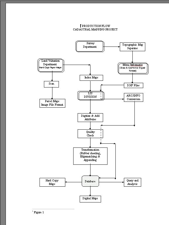
In the development of field surveying methodologies, the following lowed by transformation to the national grid, vectorization, the adding of attributes, merging of maps, editing and committal of parcel data to the master database. The steps followed in the development of the index is shown in Figure 1, Production Flow Cadastral Mapping Project.
The following is a series of tasks which describes the procedure for the creation of the cadastral index map. The data sources used are the enclosure index maps, the parcel maps both form the Valuation Department and the topographic map from the Survey Department.
1. The enclosure map are scanned. To ensure clear lines for easy line following the maps are manually touched-up prior to scanning.
2. The scanned images are then vectorized using ArcScan, table digitizing or heads-up digitizing. The approach used was dependent on the quality of the parcel map. On completion of vectorization polygon topology is built and an ARC coverage is created.
3. The parcel map is then geo-referenced to the enclosure index map using linear transformation. The raster image is also geo-referenced to serve as a backdrop for viewing.
4. Attributes information such as the valuation number, volume and folio number if the property is registered, the lot number and civic address are added to the polygon.
5. The coverage is then quality checked to ensure attribute and graphical correctness.
6. The completed enclosure coverage is then entered in to the ArcStorm database.
Stage 2 was to concentrate on the construction of a more precise and accurate digital cadastral parcel layer. This was to be achieved by digitizing deposited plans, other registered plans and diagrams; supplemented with information with field survey data and supported with a digital topographical base map. Registered and certified surveyed plans are input directly from the field notes on the plans using coordinate geometry or by digitizing to form a convenient block of on of the 235 maps, within a time frame required to begin the transformation and geo-referencing of the converted parcels to the grid system. It was decided that the exercise would be out-sourced. The specifications for the exercise were developed and a local conversion firm asked to tender. The Land Information Systems Division of the Survey Department worked in collaboration with the firm to ensure that they had the capability to deliver the product, which met the department's specifications. After 4 months, results from the testing exercise were satisfactory and approval was requested for the company to proceed with the conversion of 218 map sheets. The remaining 17 was to be done by the Survey Department. The deliverables from this exercise were as follows:
1. The road network, drainage, political boundaries, named buildings and place names.
2. TIFF and DXF files of all the above named layers.
3. The files should meet the agreed on positional, absolute, completeness and accuracy specifications.
The exercise was completed within 6 months. At the end of each month approximately 20-30 sheets were delivered. The conversion firm uses CADCORE software running on SUN Sparc 5 machines.
On delivery the sheets were converted to Arc format, transformed to the national grid system, quality checked and edgematched. If the files were found to be satisfactory they were committed to the topographical database for use. The files not meeting the specifications were largely returned to the conversion house for correction.
This exercise required great coordination and cooperation from in-house personnel and the contracting firm. We had monthly meetings to discuss the progress of the exercise, the problems being experienced and solutions to these problems. Some of the problems experienced in the exercise were as follows:
1. Some maps had poor registration marks and were very difficult to orient. To solve this problem the maps were pre-processed by the Cartographic section. Faint lines and registration marks were enhanced, and the film separates were cleaned.
2. The maps to be scanned were separate sheets some done on scribe coats and others on negative and positive film. Problems were encountered on scanning maps done on scribe material and negatives. Quite a bit of testing, scanning and re-scanning had to be done to obtain a clear image.
3. Logistical problems were experienced in the early stages of the exercise. The maps to be scanned were not being delivered on time to the conversion firm. A compromise had to be reached with personnel selecting and editing the maps for delivery. All parties to the exercise had to be brought on board at the start of the exercise their problems identified and solved to ensure cooperation and sustainability of the exercise.
1. The access to documents is manual and a very slow process. This is worsened with incorrect filing practices.
2. Many persons cannot access the same document as only one person can physically check out a document.
3. The current filing system contains duplicate information. Documents reported as being lost are re-created, and therefore there is the possibility of having two or more documents for one title.
4. The current manual system does not support the auditing and tracking of updates.
5. The is a potential security issue where original documents are deliberately hidden.
6. The documents are damaged caused by frequent handling and natural elements.
The document system was developed by Fujitsu-ICL Caribbean to provide an electronic solution for the above problems and support the streamlining of the title registration process. The document imaging system provides tools for :
* the electronic archiving of titles and supporting documents such as caveats and plans,
* the retrieval and display of previous filed documents,
* the electronic archiving of old documents
* the update of the titles index.
This system is integrated with the other database applications developed for the Office of Titles, the Dealings Tracking Information System (DTIS) and the Land Titling Information System (LTIS).
1. Documents are scanned in batches ( caveat cards are done in batches at 50) using a A3 flat bed grey scale scanner equipped with a document feed tray.
2. The documents are then index and the identifier attached which links it to related documents stored in other applications e.g. LTIS. This is usually the volume and folio number which uniquely identifies a title.
3. The image is then committed to the database.
A back file conversion operation is currently in progress for adding caveats to the imaging system.
The main applications developed are:
GLANIS - Global Land Information System
This application provides a repository for all land parcels in Jamaica. It is designed to be used by all the titling agencies, the Land Valuation and Estates Department, the Survey Department and the Office of Titles. It provides the options for querying, browsing, generating reports, updating records and maintaining the index.
When a property is subdivided by the Land Valuation and Estates Department the record of parcel creation is entered to this database, all other transactions effected by each department on this parcel is required to be entered to the database. Therefore all agencies has the responsibility of maintaining this database. The data held in this database covers parcel description, civic address, all parcel identifiers used by each department, ownership data, valuation data and surveying boundary data.
LTIS - Land Titles Information System
This application is used and maintained in the Office of Titles and information on all registered parcels. This application is integrated with GLANIS and the Dealings Tracking System. It has tools for basic querying and report generation, which provides information on registered parcels for members of the public. The application has a very versatile querying interface. Queries can be done based on owners name, volume and folio number and civic address.
These achievements have met the general requirements of users, i.e. land surveyors, land developers, real estate agents etc. and also have made advances in achieving some of the objectives outlined in the National Land Policy.