Using land use maps, over one hundred historical aerial photographs, and Esri ArcInfo vector and raster modules, a textural index was employed to characterize bush densities across two landscapes where bush encroachment has been especially severe. Photos were scanned, georegistered and merged together into multidate, composite grid stacks of ten meter resolution. Land use zones defined by roads and fencelines were convolved with these textural grids to classify pastures by degrees of bush density. Output maps proved useful for recommending to local land managers which farms to include in a bush eradication program. We believe that this technique could be applicable to characterizing other broad scale land cover modifications wherever or whenever high spatial resolution satellite imagery are unavailable.
The terms land use and land cover are often used interchangeably and incorrectly. Land use denotes human employment of the land and is the concern primarily of social scientists. Land cover denotes the physical state of the land and is the concern primarily of natural scientists (Turner and Meyer 1994). Remote sensing (RS) data are advantageous for characterizing land cover because they are objective and spatially comprehensive. Geographic information systems (GIS), while more subjective, are nontheless useful tools for describing spatial patterns in land use. As land cover is often indicative of land use, particularly in image time series, the integration of RS data with GIS for measuring and monitoring land use change is a logical and useful synthesis that has been the focus of considerable critical review (Trotter 1991, Dobson 1993, Michalak 1993, Hinton 1996, Wilkinson 1996) and applied research. Forest fragmentation (e.g. Skole and Tucker 1993), afforestation (e.g. Xu and Young 1990), and changing settlement patterns in both urban (e.g. Lo and Shipman 1990, Pathan et al. 1993) and rural (e.g. Nellis et al. 1990, Dimyati et al. 1996) landscapes are just a sampling of the many land use change processes which have been successfully quantified by incorporating RS data into GIS. The duality of raster/vector data has been problematic for interfacing RS data and GIS (Michalak 1993), although recent advancements in the use of knowledge-based systems and artificial neural networks has increased the potential to automate extraction of geographical information from RS data (Wilkinson 1996). The need for raster-based GIS modules has driven development of packages such as Esri's ArcInfo GRID, which allow easy input of RS data into GIS.
Land cover classification algorithms based on image spatial characteristics, or texture, have never been as popular as spectral-based algorithms, although important progress has been made in using textural analyses to improve spectral classifications of satellite data (e.g. Marceau et al. 1989, Franklin and Peddle 1989, Franklin and Peddle 1990, Moller-Jensen 1990, Wang and He 1990, Agbu and Nizeyimana 1991, Peddle and Franklin 1991, Kushwaha et al. 1994, Hay et al. 1996, Ryherd and Woodcock 1996). Most solely textural approaches have been in the field of pattern recognition and have not been applied to analyses of RS data (Ryherd and Woodcock 1996). Spectral data have been preferred in land cover change studies because land cover classes can often be digitally differentiated by their spectral signatures. Multidate images can be compared through differencing operations provided they are first normalized to insure that areas with unchanging land cover maintain the same brightness values. Image normalization removes variations such as different sensor calibrations on different space or air craft, sensor degradation over time, and changing atmospheric conditions. (For a more thorough discussion of these issues, see Hall et al. 1991).
Older RS data for many areas often exist only in the form of black and white aerial photographs, precluding any spectral analyses, but aerial photos possess excellent spatial detail. Computer pattern-recognition capabilities, however, still have very far to go before they can approach those of human interpreters (Hay and Niemann 1994). Consequently, land use classification of aerial photos has traditionally relied on visual interpretation. A subsequent GIS analysis involves digitizing these user-defined land use classes, measuring their areas, and then comparing these areal estimates between two or more points in time to quantify land use change. Manual land cover classifications of aerial photos followed by automated analysis in GIS has proved a demonstrably accurate, if laborious, approach to quantifying land cover change.
There are two general types of land cover change: land cover conversion and land cover modification (Turner and Meyer 1994). This is an important, although largely unrecognized distinction that has significant implications for aerial photo analysis. Land cover conversion entails a shift in the relative proportions of land cover classes within a given area, such as urban expansion into formerly agricultural land, or clearcutting of forests for conversion into croplands or pastures. It is land cover conversion that has received most notice, as it tends to be more localized and immediate in impact and therefore draws greater attention.
Land cover modification involves a shift within a particular land cover class, such as tree thinning on forested land. Land cover modification tends to occur more gradually and over a wider area, making it more difficult to perceive, but no less important. Another example, which is the focus of this paper, is the encroachment of mostly unpalatable woody plants on grazing land at the expense of desirable grasses. This bush encroachment reduces the grazing capacity of rangelands, with a consequent loss of income for ranchers. Chronic overgrazing is a global CEP; widespread bush encroachment has been observed on every continent where arid and semi-arid rangelands occur (Archer 1995).
The bush encroachment problem, although seemingly appropriate for RS data, has never been adequately quantified for three reasons. First, even relatively large savanna trees are too small to be resolved by most currently available high resolution satellite data. The Landsat satellites have been continuously mapping the earth's surface since 1972 but initially at only 80 m resolution and, since 1982, at 30 m resolution (Richards 1993). The 20 m multispectral sensors aboard the French Systeme Probatoire d'Observation de la Terre (SPOT) satellites may have the same resolution problem. Second, the 10 m resolution panchromatic sensor aboard the SPOT satellites may have adequate resolution, but the first SPOT satellite was not launched until 1986 (Richards 1993)--well after most bush encroachment had occurred. Therefore, SPOT panchromatic images might only be useful for quantifying fairly recent or current bush densities. Third, grazing lands are typically vast, making visual interpretation of large-scale historical aerial photographs too laborious. While the human eye may be unsurpassed for comparing spatial characteristics between two or three aerial photos, the human brain cannot efficiently process the dozens or hundreds required to cover large areas at multiple points in time.
Many other current and future CEP might first be perceived through subtle yet cumulatively large land cover modifications. Thus, techniques for quantifying the magnitude of land cover modification could prove beneficial for quantifying and redressing many current and as yet unforeseen CEP. Given the ample availability and low cost of historical aerial photos throughout most of the world, the simple technique outlined in this paper could be applied to other broad-scale land cover modifications, particularly wherever and whenever multitemporal satellite data are unavailable.
Many fencelines and roads existing on the land use maps and later aerial photos do not exist in the earlier aerial photos. Such linear features add texture to the land cover, so they were masked by creating 30 m buffer zones on either side of all lineaments. These liberal +/- 30 m buffer masks insured that linear features would not extend outside of the buffer zones by the additive errors of digitizing and subsequent image georegistration and resampling; i.e., the textural images subsequently generated from the aerial photo image composites would exclude edge effects and be based solely on the internal land expanse within each polygon. The buffered polygon coverage was converted into a 10 m cell grid that would define land use zones, or pastures, in the subsequent texture analysis in ArcInfo GRID.
dpi = S / (10 m)(39.37 inches/m)
where S = the scale of the aerial photo.
Before scanning each photo, a preview image was viewed on the monitor, and the scanner acquisition borders were adjusted to include only useful pictorial data and completely exclude the black borders around the photo perimeter as well as white photo id numbers. An automatic brightness/contrast adjustment feature of the scanning software (Deskscan II 2.1) was employed to objectively standardize these variables. This normalized brightness and contrast between all images as much as possible.
Each image was then georegistered to the digitized map coverage in ArcInfo. At least 16 ground control points were selected for each image, with a minimum RMS error of 1.5 pixels, or 15 m, as the accuracy threshold. Georegistered images were converted into grids and then merged into composite grids for all three years at each landscape. Due to the slight rescaling of the images during the georegistrations (an artifact of variable airplane altitude when the photos were acquired), cell sizes approximated 10 m but varied by as much as +/- 1.8 m. Therefore, each composite grid was resampled, using nearest neighbor resampling, to have exactly 10 m grid cells and exactly the same map extent as the zonal grid produced from the vector map coverage. This insured that the multidate composite grid stack would have exactly the same cell count within each zone and that grid cells would exactly overlay.
Next, the multidate textural grids were divided into several hundred zones as defined by the zonal grid produced from the vector map polygons. Using the zonal mean function in GRID, average texture was calculated within each zone; zonal mean textures were then sliced into five classes for the composite grids. The same numerical ranges were used to classify all three grids in each stack so that the multidate grids could be directly compared.
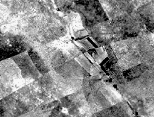
Figure 1: 1960 resampled raw image data from aerial photos
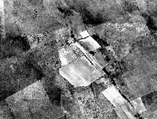
Figure 2: 1982 resampled raw image data from aerial photos
The textural index performed well in separating croplands, depicted on land use maps or observed in the field, from their generally bush-encroached surroundings. Figures 3 and 4 show textural grids derived from the 1960 and 1982 image subsets shown above. Note how the texture is less (appears darker) in croplands where bush has been cleared.
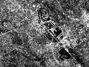
Figure 3: Textural index of 1960 image data shown in Figure 1.
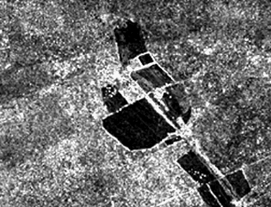
Figure 4: Textural index of 1982 image data shown in Figure 2.
Bush density classifications derived from this analysis agreed well with field observations of bush encroachment during a field expedition to the study landscapes in 1996. Figures 5 and 6 show 1960 and 1982 bush density classes, calculated by slicing zonal mean textures into five classes. The same data ranges were used to classify both grids.
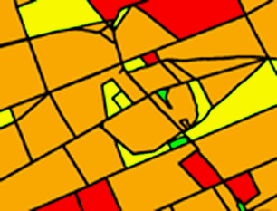
Figure 5: Bush density classification of textural grid shown in Figure 3. (red = low bush density; orange = low-intermediate bush density; yellow = intermediate bush density; green = intermediate-high bush density)
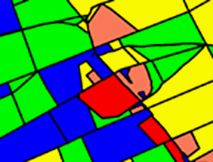
Figure 6: Bush density classification of textural grid shown in Figure 4. (red = low bush density; orange = low-intermediate bush density; yellow = intermediate bush density; green = intermediate-high bush density; blue = high bush density)
An important issue that deserves greater attention is choosing the optimal scanning resolution. The pixel size of the output images should ideally capture the grain of spatial variation in whatever land cover type is under scrutiny. It would be most useful to conduct a preliminary analysis, using variograms to establish at what scale most spatial variability is maximized (Woodcock et al. 1988). In this application, the benefit of higher scanning resolution was disproportionately offset by the cost of increased data volume; doubling the scanning resolution causes a squaring of the data volume in the resultant image. To summarize, there were three reasons for choosing the 10 m resolution for this study.
1. Ten meters was judged the minimum resolution for capturing individual trees and woody shrub clumps while still keeping data volume to a manageable level.
2. Georegistration of the aerial photos to the digitized map coverages achieved an accuracy of +/- 15 m, making a 30 x 30 m, or 3 x 3 pixel textural filter window, the smallest possible within these error bounds.
3. The 10 m resolution could prove useful for comparing these early textural grids based on aerial photos to a more recent textural grid based on a 10 m SPOT panchromatic image, should this become available.
A source of error in the analysis which could not be corrected was the "lines" where adjacent images adjoined in the merged composite. These nearly invisible lines became more apparent after the textural transformation as thin bright lines two pixels (20 m) wide. However, the effect of these linear artifacts on the zonal calculations appears negligible; these lines constitute a tiny proportion of the total image and might significantly affect the zonal calculations only in those zones which are too small to be of any real concern. Edgematching procedures can be done in ArcInfo, but the absence of many reliable landmarks in these featureless landscapes, and the number of individual images comprising each composite, made such an effort impractical in this case. Should these edge effects be a concern in future applications, then masking them out is probably the best solution.
Masking the many real linear land use features from the images using the buffered polygon coverage was an important component of this analysis for two reasons. First, it reduced sources of land cover heterogeneity to solely vegetation pattern, the object of concern. Second, these zone-defining masks served to parcel the landscape into many component pastures. This permits comparisons of land cover condition between pastures, which will prove much more helpful for farmers, agricultural extension officers, and others concerned with land management. In fact, bush classification maps produced by this method will be forwarded to just such people in South Africa who have already shouldered the task of implementing a bush encroachment remediation program.
The accuracy of this textural classification technique appears to be good but still needs to be quantified. Statistical tests for significance of canopy change are still being developed. Relative bush density classifications generated with this analysis were supported by 1996 field observations of bush density across both study landscapes. Also in 1996, field estimates of % canopy cover were made at 20 field sites. These will be used to validate bush density estimates made by visually interpreting 1994 aerial photos at the same sites. Finally, by then scanning these 1994 photos at 10 m resolution and comparing them to the older grid composites used in this analysis, the accuracy of the classifications partially presented here can be more rigorously validated and quantified.
Many people and institutions have helped or are helping to make this analysis fruitful. In South Africa, Bob Scholes and Dean Fairbanks at CSIR, Mary Scholes, Fanie Ferreira at SAC, Mike Kuus at Surveys and Land Information, Cor van der Walt at Azur Aerial Photogrammetry, Rich Davies, Marcus Hofmeyr, Moses Moeti and Bruce Brockett at Northwest Parks Board, Danie Grobler and Warren Lambert at the Council for Geoscience, Greg Stuart-Hill, Paul Maubane at Agricor, and Roland and Rita Tarr all deserve recognition. In Colorado, Ed Delaney, Keith Rokoske, Roberta Yuhas, Leanne Lestak, Greg Asner, Ann Bateson and Lee Vierling provided timely assistance.
Archer, S. 1995. Tree-grass dynamics in a Prosopis-thornscrub savanna parkland: Reconstructing the past and predicting the future. Ecoscience 2(1): 83-99.
Dimyati, M., K. Mizuno, S. Kobayashi, and T. Kitamura. 1996. An analysis of land use/cover change using the combination of MSS Landsat and land use map--a case study in Yogyakarta, Indonesia. Int. J. Rem. Sens. 17(5): 931-944.
Dobson, J.E. 1993. Commentary: A conceptual framework for integrating remote sensing, GIS, and Geography. PE & RS 59(10): 1491-1496.
Franklin, S.E. and D.R. Peddle. 1989. Spectral texture for improved class discrimination in complex terrain. Int. J. Rem. Sens. 10(8): 1437-1443.
Franklin, S.E. and D.R. Peddle. 1990. Classification of SPOT HRV imagery and texture features. Int. J. Rem. Sens. 11(3): 551-556.
Glantz, M.H. 1994. Creeping Environmental Phenomena: Are societies equipped to deal with them? In: Michael H. Glantz (ed), Workshop Report on Creeping Environmental Phenomena and Societal Responses to Them. National Center for Atmospheric Research, Boulder, CO, pp. 1-10.
Hall, F.G., D.E. Strebel, J.E. Nickeson and S.J. Goetz. 1991. Radiometric rectification: Toward a common radiometric response among multidate, multisensor images. Rem. Sens. Environ. 35: 11-27.
Hay, G.J. and K.O. Niemann. 1994. Visualizing 3-D texture: a three dimensional structural approach to model forest texture. Can. J. Rem. Sens. 20(2): 90-101.
Hay, G.J., K.O. Niemann and G.F. McLean. 1996. An object-specific image-texture analysis of H-resolution forest imagery. Rem. Sens. Environ. 55: 108-122.
Hinton, J.C. 1996. GIS and remote sensing integration for environmental applications. Int. J. GIS 10(7): 877-890.
Kushwaha, S.P.S., S. Kuntz and G. Oesten. 1994. Applications of image texture in forest classification. Int. J. Rem. Sens. 15(11): 2273-2284.
Lo, C.P. and R.L. Shipman. 1990. A GIS approach to land-use change dynamics detection. PE & RS 56(11): 1483-1491.
Marceau, D., P.J. Howarth and J-.M.M. Dubois. 1989. Automated texture extraction from high spatial resolution satellite imagery for land-cover classification: concepts and application. In: Proceedings of the 1989 International Geoscience and Remote Sensing Symposium, pp. 2765-2768.
Michalak, W.Z. 1993. GIS in land use change analysis: integration of remotely sensed data into GIS. Applied Geography 13: 28-44.
Mřller-Jensen, L. 1990. Knowledge-based classification of an urban area using texture and context information in Landsat-TM imagery. PE & RS 56(6): 899-904.
Nellis, M.D., K. Lulla, and J. Jenson. 1990. Interfacing geographic information systems and remote sensing for rural land-use analysis. PE & RS 56(3): 329-331.
Pathan, S.K., S.V.C. Sastry and P.S. Dhinea. 1993. Urban growth trend analysis using GIS techniques--a study of the Bombay metropolitan region. Int. J. Rem. Sens. 14(17): 3169.
Peddle, D.R. and S.E. Franklin. 1991. Image texture processing and data integration for surface pattern discrimination. PE & RS 57(4): 413-420.
Richards, J.A. 1993. Remote Sensing Digital Image Analysis: An Introduction. Springer-Verlag, New York, pp. 10-15.
Ryherd, S. and C. Woodcock. 1996. Combining spectral and texture data in the segmentation of remotely sensed images. PE & RS 62(2): 181-194.
Skole, D. and C. Tucker. 1993. Tropical deforestation and habitat fragmentation in the Amazon: Satellite data from 1978 to 1988. Science 260: 1905-1910.
Trotter, C.M. 1991. Remotely-sensed data as an information source for geographical information systems in natural resource management: a review. Int. J. GIS 5(2): 225-239.
Turner, B.L. and W.B. Meyer. 1994. Global Land-Use and Land-Cover Change: An Overview. In: W.B. Meyer and B.L. Turner (eds), Changes in Land Use and Land Cover: A Global Perspective. Cambridge University Press, Great Britain, pp. 1-9.
Wang, F. and D.C. He. 1993. A new statistical approach for texture analysis. Photogrammetric Engineering and Remote Sensing 56: 61-66.
Wilkinson, G.G. 1996. A review of current issues in the integration of GIS and remote sensing data. Int. J. GIS 10(1): 85-101.
Woodcock, C.E., A.H. Strahler and D.L.B. Jupp. 1988. The use of variograms in remote sensing: II. Real Digital Images. Rem. Sens. Environ. 25: 349-379.
Xu, H. and J.A.T. Young. 1990. Monitoring changes in land use through integration of remote sensing and GIS. In: Proceedings of the 1990 International Geoscience and Remote Sensing Symposium, pp. 957-960.
Dr. Carol A. Wessman
Assistant Professor, Dept. of Environmental, Population and Organismic Biology
and Fellow, Cooperative Institute for Research in Environmental Sciences
Campus Box 216
University of Colorado
Boulder, Colorado 80309-0216
Telephone: (303) 492-1139
Fax: (303) 492-5070
e-mail: wessman@hypatia.colorado.edu