David Paige, President, DataLOGIC, Inc. 1120 Bromley Road, Avondale Estates,
Georgia 30002, U.S.A.
Roy Mead, Ph.D., 8204 Trolley Square Crossing, Atlanta, Georgia 30306, U.S.A.
Abstract
Over the past several years we have
used the term "democratization" to describe the point
at which a technology has been fully adopted by the people in
an organization and used in their daily work. This paper describes
the GIS democratization process in the Southern Region of the
U.S. Forest Service. Our strategy of democratizing GIS is centered
on delivering information to our customers to support collaborative
problem solving in a timely manner. Put simply, it focuses on
providing GIS information to people who want it, when they want
it.
We illustrate our democratization experience by examining the
deployment of three key GIS technology
applications. This deployment is part of a common approach in
which business processes, data and data standards, hardware and
connectivity, and user skills are brought together in the proper
sequences. This paper is directed toward organizations which
have moved beyond the typical start-up activities of building
databases, and provides suggestions on how to approach and measure
GIS democratization.
Niccolo Machiavelli
The Prince (1513)
GIS is a new order of things in the
U.S. Forest Service, at least at the enterprise level, where GIS
is widely used, with standard processes and data. Three regions
of the Service currently have what could be considered operational
enterprise GIS's - the Southern, the Pacific Northwest, and the
Alaska regions. Although developed independently, the three systems
have basic similarities in construction and function.
The Southern Region of the Forest
Service manages over 12 million acres (5 million hectares) of
public lands in 13 states from Oklahoma to Virginia, and in the
Commonwealth of Puerto Rico. Recently, its enterprise vector
GIS database, collected at the 1:24,000 scale, was completed after
8 years of work. The region is also in the midst of a massive
4 year phase-in of a Unix based client-server computer system.
Agency-wide GIS capability was the driving force for this effort,
and it has been integrated with office automation and other information
systems as well, to provide all employees with a common computing
environment.
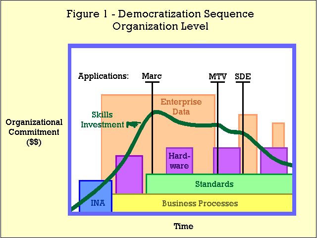
Figure 1 illustrates the coordination
between all aspects of our ongoing technology upgrade at the organizational
level of the Southern Region. Depicted specifically are the aspects
of enterprise GIS deployment, but the sequencing is applicable
in general to technology roll-outs in the Southern Region. Comprehensive
Information Needs Assessments (INA's) took place first to define
user groups and their business needs. Identified needs were based
on existing business practices and on new practices born out of
new technology capabilities. GIS enterprise core data needs were
also identified in the INA's and data collection efforts were
funded accordingly. Pilot sites were then equipped with computers
to begin the development of user applications, and standards for
collecting, maintaining, analyzing and distributing data.
Key region-wide GIS applications
were then developed as waves of new equipment were installed,
and agency investment in employee skills rose to support the increasing
number of operational GIS sites. Ancillary data acquisitions
followed the core data collection to augment total GIS functionality
as new business needs emerged.
We believe that this complex sequence
of events is necessary to facilitate the deployment of the GIS
technology in the Southern Region. But technology deployment
and actual customer use are not the same. Our intent is to democratize
GIS information, that is, to make available to all users whatever
information they want, when they want it. The delivery system
is a combination of the GIS data, applications, computers, telecommunications
networks, and skilled people.
So, the question is "How do
we democratize GIS in our organization and how do we know when
it is democratized?" To answer that question, we need to
first look at how innovations spread through organizations.
First some definitions. In this
paper we use the term "diffusion" for the process by
which GIS use propagates through an organization, by a pattern
of adoption by individuals. Adoption is the acceptance and use
of GIS by individuals in their day-to-day work. Democratization,
finally, is the cumulative measure of adoption of GIS in the organization.
We have found that understanding our diffusion processes was fundamental
for democratizing the GIS technology in the Southern Region.
Diffusion research is a body of
science with roots in the 1940's, and now thousands of articles
and texts are available in this field. Rogers (1983) defines
diffusion as "an innovation that is communicated through
certain channels over time among the members of a social system".
Knowing the diffusion channels or
"pathways" in your organization allows you to successfully
deploy an innovative technology. These organizational pathways
are composed of:
The types and levels of encouragement
available in the organization to promote adoption, such as peer
recognition, awards, and management mandate.
Basic organizational commitment or willingness to support an innovation by funding, equipment, skills acquisition, etc.
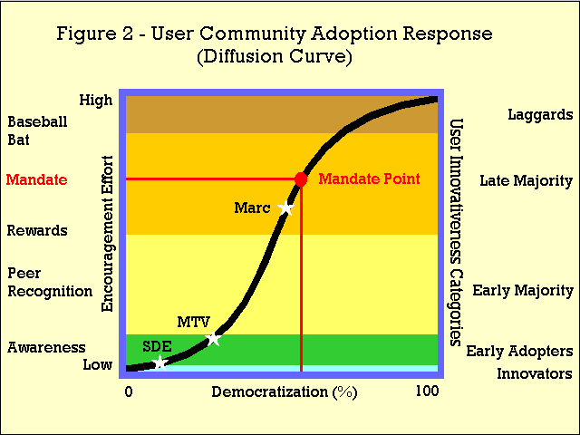
The distribution and characteristics of individuals in the
user community. The community can be segmented into category
groups based on individual skills, such as expert and novice GIS
users. Innovativeness can also be used to describe groups, such
as innovators, early adoptors, and laggards, as shown in Figure 2. Knowledge of the diffusion pathways of your organization is
essential to develop a successful democratization strategy.
Communication modes
which determine the efficiency or speed of innovation spread.
Both the type of connectivity (hierarchical or interconnected)
and media (electronic, paper publishing, etc.) are part of this
aspect of the organizational culture.
The diffusion pathways of an organization
determine how individual adoption spreads. Adoption is an individual's
choice to use an innovation in their daily work. On this individual
level, the facets of adoption are:
The innovativeness
of the user - the willingness of an individual to embrace an innovation.
The four tests of adoption --
items the user must answer in the affirmative for his or her adoption
of an innovation:
Does it meets my business needs?
Is it available and reliable?
Is it easy to use?
Is it fast?
Adoption thresholds
- these thresholds apply to each of the four tests of adoption,
and vary by the innovativeness of each user. For example, an
"innovator" might be satisfied with a lower ease of
use than a "late majority", but less satisfied with
a slow response time.
We believe a successful democratization
strategy is based upon familiarity with our organizational pathways
and the facets of individual adoption, and most importantly, on
working relationships with the innovators and early adopters in
our organization. Next, we present an example of a GIS democratization
experience in the Southern Region. It is based on developing
an integrated GIS data maintenance and delivery environment.
THE GIS MAINTENANCE AND DELIVERY
(M&D) ENVIRONMENT
The Atlanta regional office administers
13 national forest offices throughout the Southeast, and the national
forest offices in turn administer 99 ranger district offices.
In order to provide high quality GIS performance at the ranger
district offices, district GIS databases are maintained on local
computer processors. Due to the commercial communications infrastructure
in the Southeast, costs of centralizing computing would be prohibitive,
based on the intense network loads created by a fully functional
GIS community. So, we must somehow provide GIS support to our
regional users for timely delivery of fresh information in this
distributed computing environment.
The Marc editing program, the MTV
metadata program, and the SDE network GIS server programs form
the foundation of the GIS Management and Distribution environment
in the Southern Region. The three interdependent applications
are in different stages of deployment, and consequently of democratization
as well.
First released in 1995, Marc allows
our district editors to efficiently update our 99 vertically coincident
GIS databases distributed throughout the Region. Marc was designed
to specifically interface with MTV and automatically update its
metadata tables as GIS feature edits are committed.
The MTV metadata application is of pivotal importance in the Southern Region for dispensing information from a GIS physically distributed across 13 states. Now in beta test, MTV is an ORACLE application that meets Federal Geographic Data Committee requirements. It will house and report out the metadata associated with all GIS datasets. ORACLE is the agency's relational database management system, and so will serve MTV and other agency ORACLE applications at each district office. Just as MTV interacts with Marc, it must also communicate with SDE.
Our implementation of SDE includes
two interfaces - one for external Internet users and one for internal
users running ArcView, and is currently in the alpha testing stage.
SDE will warehouse and serve queries on a complete copy of the
12 million acre distributed GIS database. In order for SDE to
maintain fresh GIS data in its warehouse, it must periodically
reach out over the Forest Service wide area network and upload
current copies of district datasets. Different layers will of
course need to be updated at different frequencies based on the
editing activity. This update process or regional "roundup"
first contacts each district instance of MTV to determine if any
edits of the layer of interest have taken place since the last
roundup for that layer. If no edits have occurred, then the SDE
copy of the data is deemed current and needs no update. If MTV
reports that the data has been recently edited, then the district
dataset is uploaded to the SDE warehouse and replaces the previous
version. Then, the next district is contacted, in turn, until
the entire regional GIS roundup is complete.
So, as the GIS M&D environment,
the three key applications must work together and meet the four
user adoption tests - to be available and reliable, easy to use,
fast, and to meet user business needs.
Again, a democratization strategy
is the approach or plan for diffusion of an innovation, based
upon specific knowledge of the organization's people and culture.
Our democratization strategy for the GIS M&D environment
includes this sequence of tactics:
1. Target key individuals who will embrace good ideas
and lead with very little encouragement. These are members of the
"innovator" group.
2. Involve early adopters to refine the M&D environment, making sure that all four tests of adoption are met. Our veteran GIS database managers and editors are the keepers of business processes standards and maintain the information. Many are early adopters -- they refine our GIS business processes as the technology advances.
3. Use increasing levels of encouragement such as peer recognition and rewards to involve the early majority and some of the late majority.
4. At some point, the organizational
energy required to encourage more complete adoption by the laggards
becomes prohibitive. In Figure 2 this point is labeled the "mandate
point", and an management mandate should be considered.
When a mandate is made, the organization's encouragement effort
drops to nearly zero. The intent of mandate is to "bring
aboard" all who have not adopted the innovation, and its
effectiveness is based on the how well mandates work in the organizational
culture. Where there are few consequences for non-compliance,
there will be less adoption among the laggards.
Referring to Figure 2, we see that
the Marc, MTV, and SDE applications are all at different levels
of democratization, due mainly to their different stages of development.
We estimate that all three applications will be operating together
by December 1998, thereby offering our GIS users a fully functional
GIS environment. All three are proceeding upward on the diffusion
curve as time progresses toward full democratization. No mandate
has yet been issued, as we believe our user community is rich
in innovators, early adopters and majorities, and has few if any
laggards. Of course each user community has its own distinctively
shaped diffusion curve, which again points out the importance
of knowing the makeup of that community.
So, no, we aren't there yet, but we are moving forward. If we find that diffusion proceeds slower than expected, we should look first at how the innovation may not be meeting all four tests of adoption, and use the power of the early adopters, the keepers of the process, to help refine our offerings. We should honor our innovators for their willingness to risk, our majorities for their solid strengths, our laggards for keeping life interesting. And above all, let us remember that we are managing the "creation of a new order of things".
Machiavelli, N. 1513. The Prince.
Masser, I. and H. J. Onsrud, (eds.).
1993. Diffusion and Use of Geographic Information Technologies.
Kluwer Academic Oublishers, London. ISBN 0-7923-2190-1.
Mead, R. and R. Johnston. 1994.
Field-Level Diffusion Eases GIS Implementation Efforts. GIS
World Vol. 7 No. 11.
Rogers, E. M. 1983. "Diffusion
of Innovations", The Free Press, New York. ISBN 0-02-926650-5
Tobin, D. R.. 1993. Re-Educating
the Corporation. Oliver Wight Publications, Essex Junction, Vermont.
ISBN 0-939246-48-1.
Mr. Frye is a graduate of San Diego
State University and California Polytechnic State University San
Luis Obispo, in biology. He has been a fisheries and wildlife
biologist with the Forest Service for 12 years. Since 1992, he
has been in GIS and new technology management in the Forest Service
regional office in Atlanta.
Mr. Paige is a graduate of the University of California Santa Barbara and the Georgia Institute of Technology, and specializes in assisting clients integrate their business processes with new technologies. Dr. Mead has a Ph.D. from the University of Minnesota in remote sensing and is a recognized expert in the application of raster and vector GIS technologies to the management of natural resources.