A subdivision of environmental equity, commonly referred to as environmental justice, is concerned with environmental fairness issues as applied to minority and economically-disadvantaged segments of the population. Environmental justice became an integral part of environmental documentation as a result of Executive Order 12898 issued in February 1994. This Executive Order requires Federal agencies to incorporate environmental justice as part of their mission and to include environmental justice in the evaluation of Federal actions which could potentially affect the environment.
This paper addresses some of the techniques and issues surrounding applications of Geographic information systems (GIS) in evaluations of environmental justice. In general, GIS technology can provide both qualitative and quantitative benefits in such studies. The technology allows identification and visualization of the Geographic dispersion of low-income populations and minority populations, as well as quantitative values for racial, ethnic, and economic composition of potentially affected populations. More generally, GIS technology can provide a wide range of demographic visualization and quantification which includes economic, racial, and ethnic characteristics of the population.
Applications of GIS to evaluations of environmental justice are enhanced by ever-increasing computational power combined with the availability of plentiful demographic data in digital format. Demographic data suitable for evaluations of environmental justice are available at different levels of spatial resolution such as national, state, county , zip code, census tract, block group, or block level. As will be discussed below, spatial resolution can have a significant effect on the results of the analysis. Ideally, granularity of the resolution would be dictated by physical considerations such as the distance from a radioactive or chemical source at which potentially adverse effects become insignificant. However, it is not always practical to invoke such physical considerations. As a result, the outcome of an environmental justice evaluation may depend on an arbitrary selection for spatial resolution of the demographic data, and the resolution can noticeably impact the results of the evaluation. The concepts and issues are examined using a case study for 1,243 hazardous waste disposal sites which are regulated under the Comprehensive Environmental Response Compensation and Liability Act (CERCLA), as amended by the 1986 Superfund Amendments and Reauthorization Act, and which appear in the National Priorities List (NPL). Such sites are commonly called "Superfund sites". Although a relatively straightforward approach is used below to evaluate environmental justice at these Superfund sites, this paper will concentrate on GIS applications and issues surrounding evaluations of racial, ethnic, and economic fairness in the distribution of environmental burdens rather than presenting a detailed case for or against environmental justice for any particular type of environmental burden.
Currently there is no consensus as to basic definitions and approaches which are most appropriate for evaluations of environmental justice. Section 2 below describes basic concepts and definitions which are used in this study of environmental justice. Data requirements are described in Section 3. Section 4 is devoted to methodology and approaches, and Section 5 of the paper presents several case studies which illustrate applications of GIS. The final section provides a summary and conclusions.
Most studies of potential environmental inequities have concentrated on "disproportionate" environmental burdens rather than "disproportionately high and adverse" environmental effects (Zimmerman, 1993; Burke, 1993; Greenburg, 1993; Goldman and Fitton, 1994). This difference is important in the preparation of environmental documentation because an environmental effect can be disproportionate but not significant, and would thus not be considered disproportionately high and adverse.
Low-income populations are defined in this paper in terms of individuals having self- reported annual income below the poverty-level. Poverty thresholds are determined by the U.S. Census Bureau based on family size and the number of related children under 18 years of age in the family (U.S. Bureau of the Census, 1992). For example, the average poverty threshold for a family of four persons in 1989 was $12,674 (U.S.). The following definitions are used in this paper:
In practice, it will prove convenient to address two cases. In the first case, potentially adverse health or other environmental effects can be quantified from physical considerations. For example, if one is concerned about a source of chemical pollution, and the source location, strength, local hydrology, and prevailing meteorological conditions are known, then the potentially affected Geographic area can be defined from physical characteristics of the source and its surrounding environment. Provided that health effects of the chemicals are also quantified, evaluations of environmental equity or justice are relatively straightforward, at least with regard to the clear definition of the potentially affected area. For evaluations of environmental equity, adverse health effects on the minority population and the economically-disadvantaged population can be compared directly with those for the non-minority and non-economically-disadvantaged populations in the affected area. A similar procedure is followed in the evaluation of environmental justice, except that the adverse effects must be significant (as "significant" is used in Implementation Regulations of the United States Council on Environmental Quality). In either type of evaluation, the affected population is defined from physical principles. Uncertainties in the quantification of the affected populations are largely driven by limits of spatial resolution available from the data.
In the second case, the affected Geographic area is not quantified by physical characteristics of the source, surrounding environment, and receptors. For example, it is difficult to precisely quantify the region affected by a city or county landfill or incinerator. In such cases, the potentially affected region must be arbitrarily defined. In addition, in order to quantify "disproportionality", it is necessary to (explicitly or implicitly) define a benefited and burdened population. It has been suggested that the largest benefitted population is appropriate for the evaluation (Greenburg, 1993). An (unquantifed) adverse environmental effect is then deemed disproportionate if the minority portion of the burdened population exceeds the minority portion of the benefitted population.
Demographic data was obtained from the United States Bureau of the Census in the form of Summary Tape File 3A (STF-3A). STF-3A provides data for states and their subareas in hierarchical sequence down to the block group level (Bureau of the Census, 1992). A block group is a combination of census blocks which is a subdivision of a census tract or block numbering area (BNA). It is used to define all areas where block statistics are collected. In general, block groups contain between 250 and 550 housing units, with the ideal size being 400 housing units. Block groups are defined as that set of blocks sharing the same first digit within the census tract or BNA. In 1990, there were 229,192 blocks in the United States. STF-3A contains sample data weighted to represent the total population. In addition, the file contains 100-percent counts and unweighted sample counts for total persons and total housing units. Minority populations residing within areas of interest were enumerated with the data available from Table P-12 of the STF-3A. Estimates of low-income populations and poverty-level populations were obtained from Tables P-80, P-80a, and P-121.
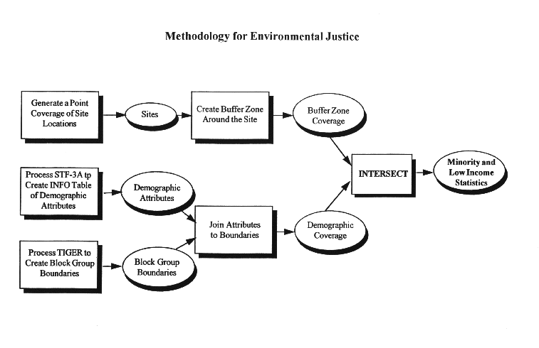
The geographic delineation of the block group boundaries, to which this demographic data are attached, is represented by the Census Bureau TIGER\Line 1992 (Topologically Integrated Geographic Encoding) files. TIGER is the digital map of the entire United States that was used to collect and compile the 1990 Census data. It is the most comprehensive database of digital mapping information, including roads, highways and census boundaries for the United States. TIGER was developed from two sources: (1) Geographic Base File/Dual Independent Map Encoding files, which are digitized maps created by the Census Bureau of 345 metropolitan and other highly developed areas; (2)United States Geological Survey 1:100,000 scale Digital Line Graph data. Each TIGER\Line file covers one county. The file contains digital data describing cartographic features (i.e., roads, railroads, streams, etc.) and partitions these features into one of three types of spatial objects: points, lines, or polygons (Marx, 1990). Using GIS software, block group boundaries in the form of polygons were built from the TIGER data.
Attributes in the INFO table were joined to the Block Group polygons using a join field which consisted of the state/county federal Information Processing Standard code concatenated with the census tract/block group number. The final step was to intersect a buffer zone coverage (representing a circular area of specified radius centered on the site) with the block group boundary coverage and calculate the minority population and low income housing statistics. For block groups that partially intersected the buffer, the population inside the buffer was allocated according to the percentage area contained within the buffer. The steps described above are summarized in the flow chart shown in Figure 1.
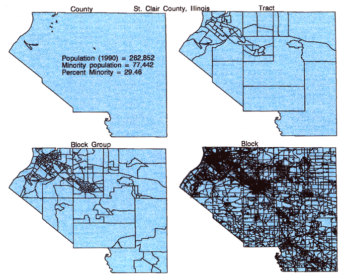
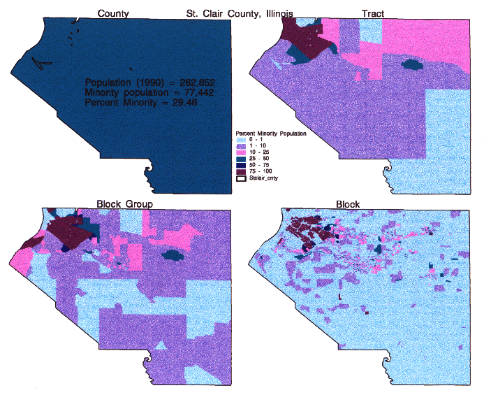
Resolution of the Geographic distribution of minorities in Saint Clair County shown in Figure 3 varies noticeably between the four levels of resolution. In general, the minority population residing in the county is aggregated in relatively small portions of the Geographic area of the county. Isolated concentrations of minorities residing in the county become more evident with increasing resolution. As will be emphasized below, an evaluation of the environmental effects of localized sources of pollution or other environmentally undesirable sources can depend on the unit of resolution. Relatively large uncertainties in the analysis can result if the unit of spatial resolution is not significantly smaller than the affected area.
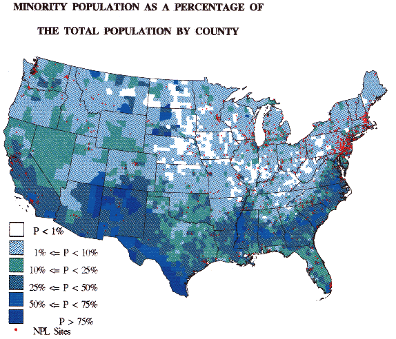
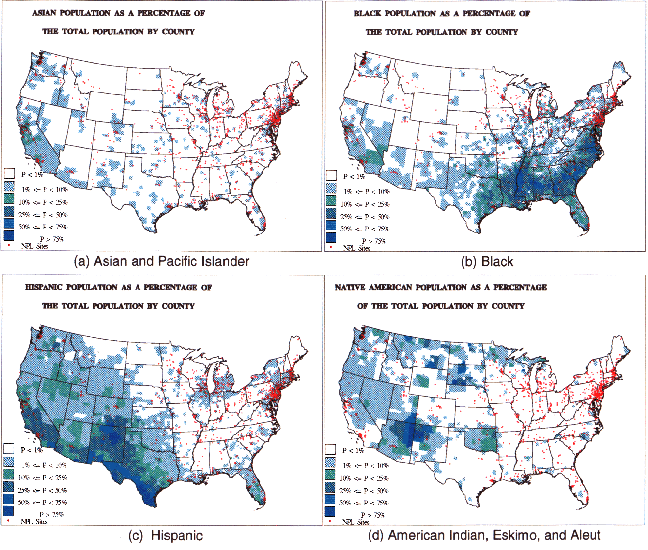
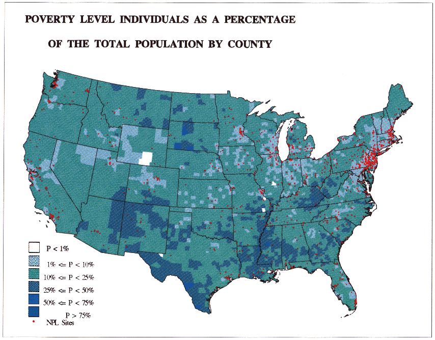
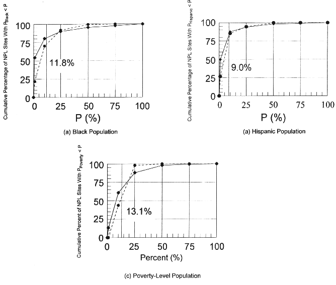
Figure 6 shows the Geographic distribution for poverty-level persons residing in the contiguous United States. County-level resolution was also used in this figure. As was found above for minority populations, no obvious visual correlation exists between NPL Site locations and concentrations of individuals having income less than the poverty level. Comparing Figures 5 and 6, concentrations of poverty-level individuals coincide with concentrations of the black population along the Mississippi River, Hispanic populations along the border between Texas and Mexico, and Native American populations residing in Arizona, New Mexico, and the Dakotas.
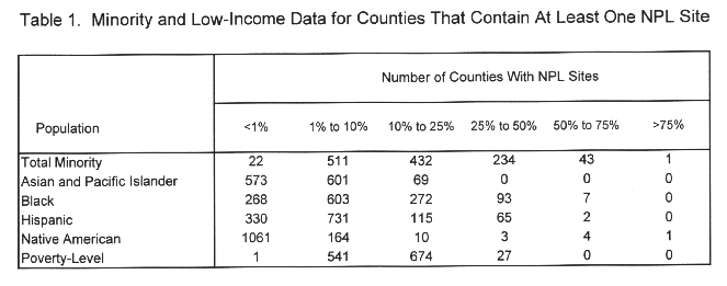
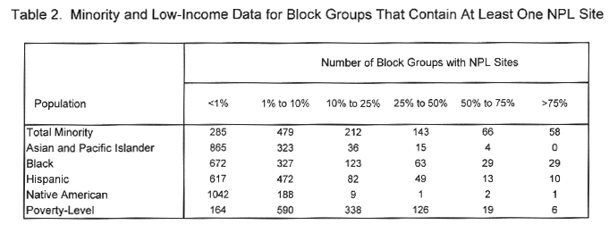
Extracting some comparisons from Tables 1 and 2:
	Less than 10% of Total			Number of NPL Sites
						County-Level	Block Group-Level
		Minority				233		  	764
		Low-Income			          1	                 77
		Poverty Level				542			654
and

	Greater than 50% of Total			Number of NPL Sites
						County-Level	Block Group-Level
		Minority				44			124
		Low-Income				0			24
		Poverty Level			  	0                       25
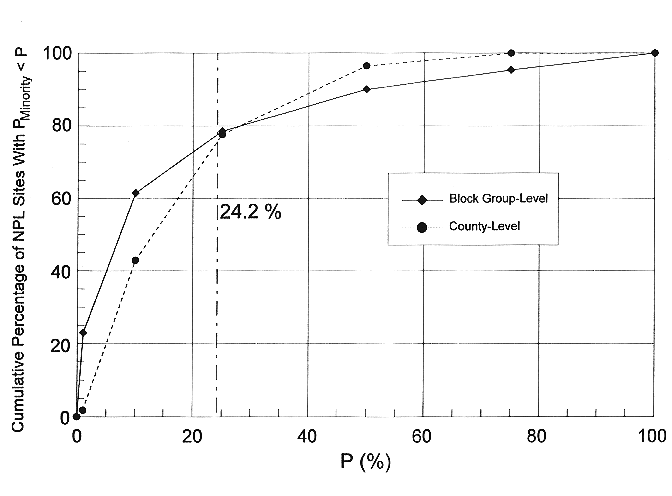
Thus, a majority of the NPL sites are located in Geographic units for which minority and poverty-level percentages of the population are less than corresponding national averages for the contiguous United States. Although the analytical approach used in this paper differs from that used in an earlier study of NPL Sites (Zimmerman, 1993), the observation that no evident trend in environmental injustice exists at NPL Sites agrees with that obtained by Zimmerman when simple numerical averages and comparison with national averages were used in the evaluation. It should be noted that when Zimmerman used a more complex analytical approach with weighted averages, a pattern of inequity was discernable. Zimmerman used United States Census Bureau defined "Places" or "Minor Civil Divisions" for spatial resolution, while this paper used county-level and block group-level resolution. County-level spatial resolution would usually be coarser than that used by Zimmerman, while block-group level resolution would generally be finer.
Neither county-level nor block group-level spatial resolution are necessarily the most appropriate choices. Until physical factors such as source characteristics, prevailing meteorological conditions, and local hydrology are combined to provide a physically defined affected area, it is not practical to arrive at an unambiguous area appropriate for a health-based analysis. Evaluations of environmental equity have used demographic resolutions ranging from block group-level to United States Postal ZIP Code-level levels in analyses of environmental justice for various toxic and non-toxic sources of environmental pollution (Burke 1993, Goldman and Fitton, 1994, USGAO 1993, Anderson, et. al., 1994). Differences in results among similar studies can be at least partially attributed differences in spatial resolution used in the analysis (Goldman and Fitton, 1994). Thus, it is desirable to use several spatial resolutions in an evaluation of environmental justice as a check on the sensitivity of results to the choice for spatial resolution.
GIS technology offers significant qualitative and quantitative benefits in analyses of environmental justice. Identification and Geographic visualization of potentially affected populations is important as a guide for the analyst. Concentrations of minority or low-income populations can be overlooked if a relatively crude unit of spatial resolution is selected for the analysis. Visualization is an especially desirable feature in environmental documentation because it provides a ready appreciation of the environmental situation for the general public.
For a health-based analysis in which the environmentally affected area is clearly defined, a unit of spatial resolution should be selected that is small relative to the affected area. If the unit of Geographic resolution is commensurate with or larger than the affected area, relatively large uncertainties in the results occur due to lack of demographic resolution near the boundary of the affected area. In cases where the environmentally affected area is not physically well-defined, then the analysis should be conducted with various units of spatial resolution as a test for sensitivity. As noted here and by others, it is often impractical to provide a physical basis for selection of the affected area, so that sensitivity tests become an important factor the analysis.
Burke, Lauretta M., 1993, Race and Environmental Equity: A Geographic Analysis in Los Angeles, Geo Info Systems, October, 1993.
Fauss, L., M. Bronson, and N.R. Bronson, 1993, Office of Emergency and Remedial Response, National Priorities List Site Coordinate Quality Assurance and Digitizing, Project Summary, United States EPA Environmental Photographic Interpretation Center, Environmental Monitoring Systems Laboratory, Warrenton, VA.
Goldman, Benjamin A. and Fitton, Laura, 1994, Toxic Wastes and Race Revisited, An Update of the 1987 Report on the Racial and Socioeconomic Characteristics of Communities with Hazardous Waste Sites, Published by the Center for Policy Alternatives, 1875 Connecticut Avenue NW, Suite 710, Washington, DC, 20009.
Greenburg, Michael, 1993, Proving Environmental Inequity in Siting Locally Unwanted Land Uses, Risk - Issues in Health and Safety, Summer, 235- 252.
Marx, R.W., 1990, The TIGER System: Yesterday, Today, and Tomorrow. In: Cartography and Geographic Information Systems, R.W. Marx (Ed.), Journal of American Congress on Surveying and Mapping 17(1): 89-97.
United Church of Christ Commission for Racial Justice and Public data Access, Inc., 1987, Toxic Wastes and Race in the United States: A National Report on the Racial and Socioeconomic Characteristics of Communities with Hazardous Waste Sites, Published by the United Church of Christ Commission for Racial Justice, New York, N.Y.
United States Bureau of the Census, 1992, Summary Tape File 3 on CD-ROM, 1990 Census of Population and Housing, Technical Documentation / prepared by the Bureau of the Census. -- Washington, DC.
United States Environmental Protection Agency (USEPA), 1991, NPL Characterization Project: National Results, Office of Solid Waste and Emergency Response, EPA 540/8-91/069, 108p.
United States Government Accounting Office (USGAO), 1995, Hazardous and Nonhazardous Waste, Demographics of People Living Near Waste Facilities, Washington, D.C., GAO/RCED-95-84, June, 1995.
Zimmerman, Ray, 1993, Social Equity and Environmental Risk, Risk Analysis, 13, 649-666.