The Interrupted Goode Homolosine projection (Goode's) is an interrupted, pseudocylindrical, equal-area, composite map projection that can present the entire world on one map. Global land masses are presented with their areas in proper proportion, with minimal interruption, and minimal overall distortion.
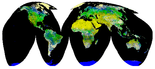
Vector and raster data in the Goode's projection are available to the spatial data community from a variety of sources. One of these sources is the U.S. Geological Survey's (USGS) EROS Data Center (EDC). EDC currently provides imagery and derived data sets such as the Global Land 1-kilometer Advanced Very High Resolution Radiometer (AVHRR) imagery of the world land masses, a corresponding raster land/water mask generated from World Vector Shoreline and Digital Chart of the World (DCW) drainage layer sources, and the 1-kilometer Global Land Cover Characterization data set. Future imagery such as the Moderate Resolution Imaging Spectrometer (MODIS) and SPOT Vegetation imagery will also be provided in the Goode's map projection. These data can augment scientific investigations, but the user must be able to project data into and from the Goode's map projection in order to use these data sets with data in other map projections.
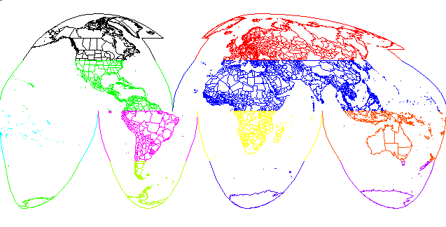
The Interrupted Goode Homolosine map projection is composed from twelve discrete regions that combine to form six interrupted lobes. The two northern regions are often presented with land areas repeated in both regions, allowing these land areas to be shown without interruption. The Goode's projection currently is not explicitly supported in Geographic Information System (GIS) software packages such as ArcInfo3. Fortunately, it can be simulated by combining twelve instances of the Mollweide and Sinusoidal map projections, both of which usually are supported in GIS software packages. Vector and raster data can be projected into the Goode's projection by splitting it into the appropriate Goode's regions, projecting each region using its component map projection (Mollweide or Sinusoidal) and offsets, and joining the reprojected regions into one data set. Vector data stored in other map projections have been projected into the Goode's projection at product generation time in ARCPLOT. This was accomplished through the use of appropriate logical RESELECTs of features and the repeated use of the MAPPROJECTION environment.
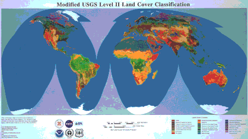
Vector and raster data sets in the Interrupted Goode Homolosine (Goode's) projection are available to the spatial data community from a variety of sources, including the U.S. Geological Survey's (USGS) EROS Data Center (EDC). At EDC, global data sets of remotely-sensed raster imagery are being compiled. The imagery for these data sets are medium-resolution. The Goode's projection was chosen for use with these data because it provides minimal distortion over the world's land areas, helping to preserve the information content of the imagery. These data sets include the Global Land 1-kilometer Advanced Very High Resolution Radiometer (AVHRR) imagery of the world land masses (Figure 1), a corresponding raster land/water mask generated from World Vector Shoreline and Digital Chart of the World (DCW) drainage layer sources, and the 1-kilometer Global Land Cover Characterization data set (Figure 2). Future imagery such as the Moderate Resolution Imaging Spectrometer (MODIS) and SPOT Vegetation imagery will also be provided in the Goode's map projection.
The Goode's projection is an interrupted, equal-area, world map projection. Global regions are presented with their areas in proper proportion, with minimal interruption, and with minimal overall distortion. Developed by Goode (1925) to provide an effective alternative to presenting global areal relationships on the Mercator projection, the Goode's projection has variations for presenting the world's land masses or the world's oceans. The variation presenting the world's land masses is considered in this paper.
The Goode's projection has had limited use by the cartographic community. It is a featured map projection in Espenshade (1995), used to present spatial and density distributions of many categories of areal data. It is used less extensively, but for similar purposes, in The International Atlas (1988).
ArcInfo (7.2 release) does not support the Goode's projection as an integrated map projection. This is a problem. The imagery listed above is in the Goode's map projection. To use the imagery, users must either project their data layers into the Goode's map projection or project the imagery into another map projection. The reprojection of raster imagery is not desirable because the image resampling process does not adapt to variation in map projection distortions (Steinwand and others, 1995). Since the Goode's projection is a composite of the Sinusoidal and Mollweide map projections which are supported in ArcInfo, Arc users can simulate the Goode's projection. Vector data can be projected from any projection supported by Arc into the component projections of the Goode's projection. Spatial features can be mapped into the Goode's coordinate space a region at a time.
This paper describes the Goode's map projection and how vector data can be projected into the Goode's coordinate space for use with data already in this map projection.
Map projections are tools that project features from a round surface onto a flat plane. Many map projections have been defined, each with its own set of properties. These properties make some map projections more desirable than others for use with specific applications. Because each application that uses map projections has its own requirements, it is not possible to establish a "best" map projection for overall use. It is useful to consider properties that allow map projections to be classified and evaluated for use in specific applications. An understanding of these properties is helpful when evaluating the utility of any map projection for use in a specific application.
The properties of map projections and the ability of these properties to control distortion have been adequately described in a number of sources. Snyder (1987) presents a more complete discussion of this topic. Snyder and Voxland (1989) provide useful information about map projection properties and present graphics for a number of map projections. Pamphlets such as Robinson (1986), Robinson (1988), and Robinson and others (1991) provide discussions that contribute to a reasonable understanding of the properties of map projections and the control of distortion. Appendix 1 summarizes these properties.
Global monitoring projects using remotely-sensed raster imagery need a map projection that supports the collection, registration, compositing, archiving, analysis, and presentation of this imagery. Each of these tasks has special needs that suggest selecting some map projections and not others. Since it is not currently feasible to change map projections for each activity of a project, it is necessary to compromise on a map projection that serves most of a project's needs.
Of the conformal, equal-area, equidistant, and azimuthal properties, the equal-area property is the most important when dealing with raster imagery. The raster pixels that compose imagery are areal in nature. Each pixel represents the area contribution of its corresponding ground location. Image processing software operates on an image, processing each pixel as yet another unit. The software functions as if the pixels are all the same size. When the imagery is in an equal-area map projection, image processing operations affect similarly-sized ground regions, and area calculations are then simplified.
Gerardus Mercator presented what has come to be known as the Mercator map projection in 1569 as an effective navigational tool that featured straight rhumb lines. While it is an excellent map projection for this purpose, the Mercator projection was never intended to be a general-use world map projection. It can not display the entire Earth on a world map. The north and south poles are not visible because they lie at infinity in the Mercator Cartesian coordinate space. It is inappropriate for the presentation of areal relationships because the Mercator map projection is a conformal, not an equal-area map projection. The sizes and shapes of large regions are distorted, especially near the poles. The Mercator map projection has been commonly (and incorrectly) used for general-purpose world mapping because it nicely fills a rectangular page and is easily constructed. Because it is seen so often, its use is seldom questioned.
J.P. Goode proposed several map projections and variations. The most common of these is the Goode's projection referred to in this paper, the Interrupted Goode Homolosine map projection with cap extensions in the northern regions. The Goode's projection is described and classified as an interrupted, pseudocylindrical, equal-area, composite map projection. It was developed in 1923 to provide an effective alternative to portraying global areal relationships on the Mercator map projection.
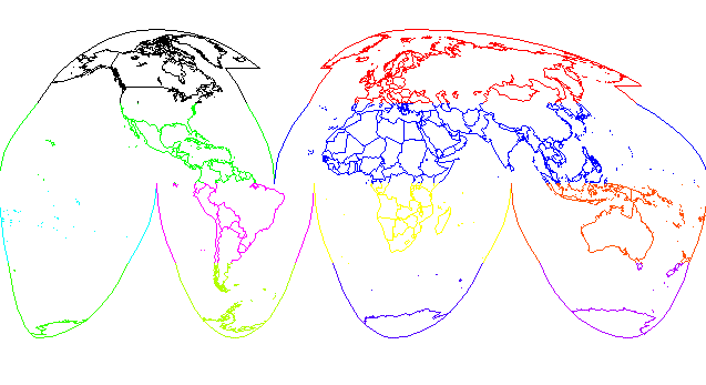
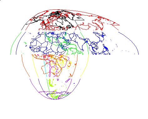
Interrupted means that, in an effort to reduce peripheral distortion, the mapped surface of the world has been split into six lobes (Figure 3). Each lobe spans a region of the Earth from the Equator to a pole. The lobes are not symmetrical about the Equator. The six lobes are split along meridians passing through the major oceans, and correspond to five of the major continental land masses and the South Pacific. The intention is to present the world land masses with as little interruption as possible and still hold distortion to a minimum throughout the world. Antarctica is the only major land mass that is split. Strictly speaking, Greenland and northeastern Asia's Chukotski Peninsula and Wrangel Island should also be split because the meridians dividing the northern lobes run through them. These regions are often presented intact by adding cap extensions to the northern lobes. The cap extensions cause some places on Earth to map to two locations in the map projection. Cap extensions also graphically present the relationships of the affected features with their neighboring features in both lobes. Some implementations of the Goode's projection do not support the cap extensions because of the double mapping. The central meridian chosen for the Eurasian land mass provides lower distortion in the regions of Europe and northern Africa, but distortion becomes noticeable in northeastern Asia. The level of this distortion is slightly greater than the level that occurred with the Bonne projection that was commonly used to present Asia when Goode developed the Interrupted Homolosine projection (Goode, 1925).
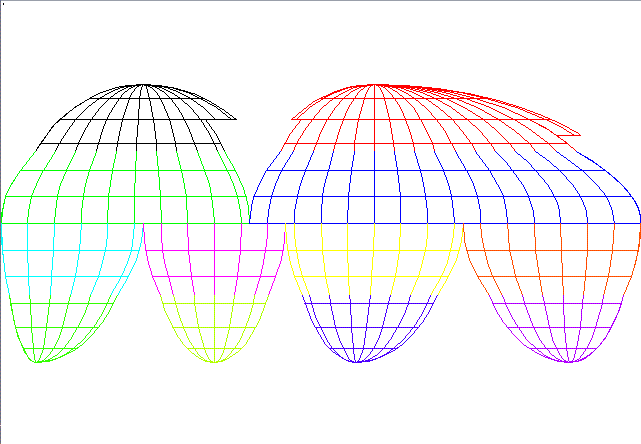
Pseudocylindrical means that the projection features straight horizontal lines for parallels and has meridians equally spaced along the parallels. Unlike the cylindrical map projections, meridians in pseudocylindrical map projections are usually curved. The central meridians of each lobe in the Goode's map projection are straight lines running from the Equator to the poles. The other meridians curve toward their lobe's central meridian and intersect at the pole. The straight-line, horizontal parallels facilitate the comparative study of world features by latitude. The graticule, or network of lines representing selected parallels and meridians for the Earth, features horizontal lines for the parallels, curved, evenly-spaced vertical lines representing meridians, and poles at the extreme ends of each lobe's central meridian (Figure 4).
Equal-area means that areas of all regions are shown in proportion to their true areas on the ground. The distortions required to produce the equal-area property are at a minimum near the Equator and along the central meridians of each lobe. This provides for better overall distortion control than would be possible with an uninterrupted map projection of the world.
Composite means that the Goode's projection is formed from more than one map projection. In this case, the map projections are the Mollweide and the Sinusoidal. The Mollweide projection is used to map the poleward regions of each interrupted lobe. The Sinusoidal projection is used to map the Equatorial regions of each interrupted lobe (Figure 5).
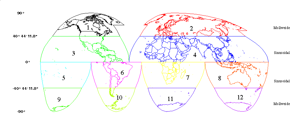
Scale properties are determined by the component projection for each region. The Sinusoidal regions of the projection present true scale along every latitude and along the central meridians of the lobes. This has the effect of evenly spacing the parallels and of making distance measurements accurate along the lines of latitude and the central meridian. The Mollweide regions of the projection present true scale only at ±40° 44' 11.8". Scale is otherwise constant along a given latitude and the same at the corresponding, opposite latitude, but scale varies between latitudes (Figure 4 and Figure 5).
Distortion properties are determined by the component projection for each region. The Sinusoidal regions present no distortion along the Equator and the central meridian of each lobe. Distortion occurs away from these lines, and becomes most severe at high latitudes, away from the central meridians. The Mollweide regions are distortion free only where their respective central meridians intersect the latitudes ±40° 44' 11.8". Distortion is again most severe at high latitudes, away from the central meridians (Figure 4 and Figure 5).
The Goode's map projection offers an effective compromise, balancing the equal-area and minimum distortion needs of global land data sets. The major limitation to its effective use is in the polar regions, where lobe interruptions and the inability to cross over the pole interfere with the formation of a proximal view of the region. Unfortunately, the Goode's projection has not been widely implemented as an integrated map projection in GIS and image processing software. When the Goode's projection has not been implemented in a user's GIS, the user may be able to simulate the projection by appropriately applying its component Sinusoidal and Mollweide map projections.
The Goode's map projection is formed on a Cartesian coordinate plane. Units of measure for the map projection are usually specified in meters. The Cartesian origin, (0,0), coincides with the geographic Longitude/Latitude coordinates of (0° East, 0° North). The Cartesian coordinate space is defined everywhere on the coordinate plane. The geographic coordinate space is undefined in the gaps between the lobes.
The Earth's surface is presented on six lobes, mapped onto the Cartesian plane with appropriate offsets. The lobes join along the Equator. Each lobe is divided into two regions at the parallels ±40° 44' 11.8". Thus, the Goode's projection is formed from 12 separate regions and effectively, 12 separate map projections. Projection of the geographic Longitude/Latitude coordinate space onto the Cartesian coordinate plane is governed by the input geographic location and the Goode's region that it is being projected into. Note that when cap extensions are used, some geographic locations will be mapped to two locations on the Cartesian coordinate plane.
Each component map projection is a world map projection in its own right. As such, it has its own Cartesian coordinate plane. Geographic (Longitude,Latitude) locations are mapped to Cartesian coordinate (x,y) locations for every point on Earth, not just the geographic locations belonging to a Goode's region. The component map projection's origin at (Longitude,Latitude) location (central meridian, Equator) is mapped to the Cartesian origin at (0,0). To map geographic data into any component region of the Goode projection, the geographic data must be clipped to the desired region's boundaries and projected into that component projection. Extending the clipping boundary allows geographic data that falls outside the nominal boundaries of a region to be mapped as an extension to that region. This is one method for handling the cap extensions.
If the component map projections are clipped to the prescribed geographic extents (Appendix 2) and plotted on a common Cartesian coordinate plane, the result appears as in Figure 6. The origins of each component projection are aligned at the Cartesian origin, (0,0), and the plot lays out accordingly. The component regions lie on the proper side of the Equator, but they overlay each other in their northern or southern hemispheres. The polar regions are separated from the Equatorial regions by a gap, but they overlay each other. To place the component regions in their proper locations for the Goode's map projection, appropriate false eastings must be applied to each of the Sinusoidal component map projections. The same false eastings and appropriate false northings must be applied to the Mollweide component projections to align them with the Sinusoidal components and to join them at the respective latitudes ±40° 44' 11.8".
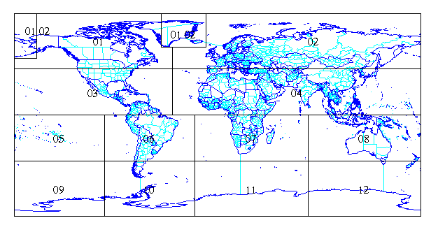
It is useful to refer to the regions of the Goode's projection by an identifying region number. The convention used here (Figure 5) assigns the upper left region the number 1 and proceeds across and down the projection. This results in labeling the North American lobe regions 1 and 3, and labeling the Australian lobe regions 8 and 12. This convention is used in the appendices to identify information for each region.
The Goode's map projection is supported as an integrated map projection in the Land Analysis System (LAS) image processing software package at the EROS Data Center. LAS is used to process remotely-sensed raster imagery from a variety of sensors, including the 1-kilometer AVHRR imagery. Source code for a utility program that converts latitude/longitude coordinates into image line/sample coordinates for Global Land 1-kilometer AVHRR imagery and for the Global Land 1-kilometer AVHRR Pathfinder imagery was developed by Steinwand (1994) and is available on the world-wide-web at
This utility program is written in the C language, and is offered for distribution without support. Note that this implementation provides a one-to-one mapping between locations on Earth and locations in the map projection. It does not support cap extensions.
Because the Goode's projection has not been implemented in many GIS and image processing software packages, it is necessary to simulate the Goode's projection by projecting data into the Goode's Cartesian coordinate space using the Goode's component map projections. Data from each input coverage must first be partitioned into the component Goode's regions. The spatial extents of the Goode's regions are most easily defined in the geographic coordinate space.
A double precision, geographic coverage of the Goode's regions was generated in ARC using a polygon input file (Appendix 2). This file/coverage defines the geographic extents of each of the Goode's regions. Vertices in the resulting coverage are sparse, occurring only at the corners and intersections of the polygons defining the regions. The geographic Earth is partitioned into 14 regions instead of 12. The two extra regions are the portions of Region 1 and Region 2 that must be projected twice to produce the cap extensions.
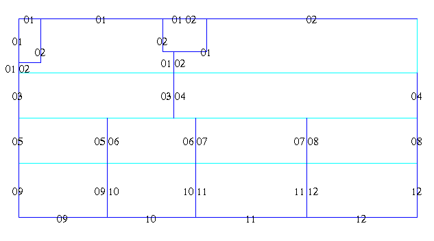
Polygon topology was built for the generated coverage. Each polygon was assigned a 5-character label to store its Goode's region number. Most of the polygons were labeled with a 2-character region number. The code "01" was used for Goode's region 1, and so on. The leading "0" is added to the single digit region numbers to make it easier to select desired regions. The cap polygons were labeled with "01 02" (Figure 7). The resulting coverage is useful in this form as an overlay template for geographic coverages. If this coverage is to be reprojected for use with input coverages in other projections, it needs to be densified with vertices at least at every degree so that the Goode's boundaries show appropriate curvature in the required map projection.
The Goode's map projection can be simulated by appropriately projecting data from any supported input map projection to the appropriate Goode's component output map projections. The following discussion demonstrates the simulation of the Goode's projection using geographic input coverages. This is a reasonable and realistic simplification because many global vector data sets are stored using the geographic coordinate system. The simulation procedure uses the ARCPLOT environment to generate an output product, not a coverage. A procedure simulating the Goode's projection from the ARC environment, generating output coverages, is left to another paper.
Simulation of the Goode's projection requires the development of each region component. Features from an input coverage are selected for the Goode's region that is being processed. In ARCPLOT, this is accomplished with the RESELECT command.
Twelve projection files are provided (Appendix 3) that establish the MAPPROJECTION environments needed to project geographic features into each region's component map projection. The reader is cautioned that the Mollweide projection is not implemented with false eastings and false northings as part of the map projection parameters. Needed offsets are handled with the XSHIFT and YSHIFT subcommands for PROJECT. If the reader wishes to project from Mollweide back to another map projection, the signs on the XSHIFT and YSHIFT values must be reversed.
The following AML illustrates the procedure for projecting WORLDGOODES, a geographic coverage of the world, into the Goode's projection. WORLDGOODES was created by performing a polygon INTERSECT of a geographic coverage of the world with the geographic coverage of the Goode regions. For disk housekeeping convenience, the 12 projection files were stored in a subdirectory of the current workspace called "projections".
              /* world mapextent in Goode's coordinates
mapextent -20015500,-8673500,20015500,8673500
linecolor 1
&do i := 1 &to 12   /* loop through each of the regions
   &if %i% < 10 &then
      &setvar i := 0%i%    /* pad with a leading 0, where necessary
   clearselect
   reselect WORLDGOODES poly region cn [quote %i%]
   mapprojection projections/dd.r%i%  /* path to the 12 projection files
   polys WORLDGOODES
   mapprojection off
&end /* end of do loop
&return
Performing a polygon INTERSECT partitioned the polygon features of the
input coverage into Goode's regions, supporting polygon operations like
POLYGONSHADES. The polygon INTERSECT had the side effect of
adding undesirable lines at ±40° 44' 11.8", at the Equator,
and at 180° in Region 2. This made the use of the POLYS command
questionable because region boundary lines were plotted even though they
were artificial
(Figure 5
and
Figure 8).
This problem was addressed by establishing and using line topology. The
input world coverage was built to line topology. It had a perimeter box
around the world running at ±180° longitude and ±90°
latitude. Because the perimeter box contributed unwanted lines to the
output plot in the northeast Asia cap extension, the world coverage was
edited and the perimeter box was deleted. A line INTERSECT was performed
on the edited world coverage, using the polygon Goode's coverage to split
world features into the Goode's regions and assign the Goode's region
numbers to the line features. The Goode's region boundaries were not
included in the resulting line coverage. This eliminated the offending
boundary lines, but it also eliminated the lobe outline that provided
closure to the Goode's projection.
A line coverage called GOODESLINES was developed from the polygon Goode's region coverage. GOODESLINES provides a source for the Goode's lobe boundaries. It was intended to be plotted with a world line coverage to provide closure to the Goode's lobes (Figure 3). The polygon Goode's region coverage was copied to a new coverage and edited to delete the internal horizontal lines at ±40° 44' 11.8" and 0°. The vertical line at 180°, north of 40° 44' 11.8" was also deleted. Goode's region number labels like those labeling the Goode's regions in the polygon coverage were assigned to the remaining line segments (Figure 9). Several of the lines were assigned two region numbers because those lines defined the lobe edges of adjacent Goode's regions. GOODESLINES then was densified so that there were vertices at least at every degree. The following AML illustrates the presentation of a geographic world coverage in the Goode's projection, omitting undesired internal Goode's boundary lines.
              /* world mapextent in Goode's coordinates
mapextent -20015500,-8673500,20015500,8673500
linecolor 1
&do i := 1 &to 12   /* loop through each of the regions
   &if %i% < 10 &then
      &setvar i := 0%i%    /* pad with a leading 0, where necessary
   clearselect
             /* reselect world's arc features
   reselect WORLDGOODES arc region cn [quote %i%]
            /* reselect goodesline's arc features
   reselect GOODESLINES arc region cn [quote %i%]
   mapprojection projections/dd.r%i%      /* path to the 12 projection files
   arcs WORLDGOODES
   arcs GOODESLINES
   mapprojection off
&end /* end of do loop
&return
Polygon topology was lost with the line INTERSECT operation, but polygon
topology is often neither required nor desired when drawing vector data
over imagery. Polygon shading usually is unwanted on imagery. When
polygon shading is needed, the first AML can be modified to use the
POLYGONSHADES and DROPLINE commands. Polygons will break at the Goode's
region boundaries, but the polygon shading will hide this if the polygons
are not outlined.
An attempt was made to use the RESELECT command with the OVERLAP option. The intent was to select features from an input coverage for projection into the Goode's component map projections using a spatial template. The anticipated advantage from this approach was that any input coverage or library layer could be paired with appropriate spatial templates and projected into the Goode's projection. No special preprocessing would be needed to add Goode's region attributes to each input coverage feature. This advantage would be most valuable when using LIBRARIAN libraries like the DCW (Klaver and Lethcoe, 1994).
RESELECT OVERLAP overlays the input coverage or library layer with the designated spatial template. The internal processing is similar to running the INTERSECT command in ARC, but no output coverage is generated. As with INTERSECT, processing large coverages can take a significant amount of time. If the input coverage or library layer is needed in the Goode's projection frequently, the time required to select input features for projection could override the space-saving advantage of the RESELECT OVERLAP method.
Unfortunately, the results from the spatial template approach are not acceptable. The overlay processor does not generate temporary nodes in the input coverage or library layer at the template boundaries. As a result, features are not clipped at the region boundaries. The RESELECT OVERLAP command uses either PASSTHRU or WITHIN options. PASSTHRU allows an arc to pass through a region boundary to an adjacent region or to a gap between the Goode's lobes. WITHIN truncates arcs at the last node before they intersect a template boundary. Using simple world coverages, PASSTHRU selects virtually everything in the coverage, while WITHIN selects virtually nothing. Using the DCW library, results are more favorable than with the simple world coverages. The 5° tile structure in most of the library enables most of the desired features to be properly selected for each Goode's region. Still, the general lack of nodes at the Sinusoidal/Mollweide boundaries causes problems. Features crossing region boundaries are either truncated using WITHIN, or sprawl into a neighboring region using PASSTHRU. Antarctica is a significant problem because it resides on large tiles that do not align with the Goode's region boundaries. The continent either sprawls into the gaps between lobes using PASSTHRU, or virtually disappears using WITHIN.
Since the spatial RESELECT did not work adequately for our simulation, it was necessary to use a logical expression for feature selection. Features in the input coverage had to be split at Goode's region boundaries. Goode's region numbers then had to be assigned to each feature in the input coverage. Both of these tasks were accomplished by intersecting the input coverage with the Goode's region coverage in ARC. Then, in ARCPLOT, all of the features belonging to a Goode's component region were selected using the RESELECT command with the logical expression option and projected into the proper component map projection.
Feature selection using the RESELECT logical expression option and projection of the selected features belonging to the selected Goode's region worked. There are advantages and disadvantages to this approach. Once an input coverage has been intersected, a logical RESELECT retrieves all of the qualified features for a region. No features cross a region boundary, and there are no corridors of missing data. The RESELECT logical expression option is usually much faster than the spatial RESELECT option. The intersected input coverage can also be used as a preliminary step for generating an output coverage in the Goode's projection.
The significant disadvantage to the INTERSECT/logical RESELECT approach is that the INTERSECT has to be run at all. The INTERSECT command runs on coverages, not LIBRARIAN library layers. INTERSECT can be indirectly run against a library layer by executing it in a VISIT command. In effect, INTERSECT is run against the coverage supporting the layer of interest in each tile. New output coverages are generated in each tile workspace. In the end, a new library layer must be created. This may at least temporarily require a great deal of disk space, and it greatly complicates the task of using LIBRARIAN library layers in the simulation of the Goode's map projection.
Due to its interrupted and composite nature, the Goode's map projection behaves like 12 separate map projections, not one. It can be dealt with either by generating coverages in the various component map projections, or by adding region attributes to existing world coverages so that selected portions of the coverage can be projected as needed in ARCPLOT.
The Goode's map projection is not supported as an integrated map projection in ArcInfo. It can not be named as the map projection when a geo-dataset is described, and it can not be referenced in the project command. There is no direct mapprojection environment support. Since there are 12 active map projections, the resulting coverage is not seamless unless it is MAPJOINed and edited. ARCPLOT commands such as DROPLINE are of limited use because they still draw region boundary lines.
While the Goode's map projection can be simulated in GIS software with a little work, the disadvantages of being an unsupported projection are vexing. Esri and other GIS/image processing software vendors are urged to explicitly support the Goode's map projection.
The art of map projection could be described as the controlled
application of distortion. The word "distortion" has an unfortunate
negative connotation. It implies that something is being improperly
represented. In fact, the projection of relationships that exist on a
round surface to a flat plane requires distortion of some of the
relationships on the round surface. Distortion is typically found in
the representation of areas, angles, shapes, scale, and direction.
Small, limited regions of the surface of the Earth are mapped on large-scale
maps. These limited regions are reasonably approximated by a flat plane,
just as a map is drawn on a flat plane. Distortion of all types is minimal
on these large-scale maps.
As the size of a study area increases, a greater portion of the Earth's
curved surface must be mapped. This requires ever greater amounts of
distortion to project relationships from the curved surface onto the
flat plane. Presentation of world-sized study areas on small scale maps
produces significant distortion somewhere on the map.
Four properties relating to map distortion are: equal-area,
conformal, equidistant, and azimuthal. Map
projections may have more than one of these properties, but they can
not have all of them at the same time. The equal-area and conformal
properties are mutually exclusive and can never exist in the same map.
Equal-area map projections present areas on a map in correct
proportion to their corresponding areas on the Earth. This property
holds true everywhere on an equal-area map. The equal-area property
is gained by distorting shapes, angles, and scale on most parts of the
map. There are usually some parts of equal-area maps where this
distortion is designed to be minimal. Applications where the comparative
display of areas is important need map projections with the equal-area
property. It is also beneficial to use equal-area map projections with
small-scale applications that display imagery.
Conformal map projections present correct relative angles at
each point on a map. This is done by maintaining a constant scale in
all directions at any single point, and at the same time, allowing the
scale to vary between points. There are usually one or two points of
singularity on conformal world maps where local angles are distorted.
When correct local angles are maintained, local shapes hold true.
Small features on conformal maps are generally shaped correctly.
Larger features, especially on world maps, suffer significant shape
and size distortion. Conformal map projections are commonly used in
large-scale mapping. Conformal maps are important tools for navigation
and technical purposes. The significant shape and size distortion found
in conformal world maps makes their use for general world mapping less
desirable.
Equidistant map projections correctly model the distances between
points. Accurate distances on a flat map result when a constant
scale is maintained between the points of interest. It is
necessary to shrink or stretch various parts of curved surfaces to
represent those surfaces on the flat plane of a map projection. These
operations necessarily cause the local scale to vary, and the scale
variation renders the task of maintaining a constant scale everywhere in
the map projection impossible. Distances cannot be correctly presented
everywhere in a world map projection. There can be one or more lines
in a world map projection where scale is presented correctly. One
equidistant map projection might maintain the scale from one or two
selected points to every other point in the map projection. In such
a map projection, scale will vary along any measurement that does not
pass through one of the designed points in a straight line. Another
equidistant map projection might maintain scale along the Equator and each
meridian, but not along any other lines. Still another map projection
might maintain scale along the Equator, the central meridian, and along
each parallel, but not along any other lines.
Azimuthal map projections present the correct direction from
the center point of a map projection to all other points in that map
projection. The directions between any pair of points that does not
include the center point of the map projection will probably be
incorrect. Azimuthal map projections differ from most conformal map
projections in that, while conformal map projections present correct
local directions on a map for points and small features, the direction
of the shortest route between two points some distance away will
probably be incorrect. This is because the shapes and sizes of larger
features in a conformal map projection are often distorted. Azimuthal
map projections may also be conformal, equal-area, or equidistant at
the same time.
Other considerations influencing the choice of map projections include:
the size of the project's study area, the location of the study area
with respect to the distortion patterns of the map projection, the
proximal presentation of the study area while avoiding unnecessary
interruption, the support of raster data in addition to vector data,
and the availability of the map projection in software packages.
When possible, it is desirable to place a study area in the minimally
distorted regions of a map projection. This is often done by selecting
a central meridian for the projection from one of the internal meridians
of the desired study area. At times it can be done by choosing a
transverse form of a map projection. The projection is aligned with an
appropriate meridian from within the study area, or by selecting an
oblique aspect of a map projection that is centered in the study area.
These techniques are effective for small and regional study areas.
World study areas are not effectively handled using these techniques.
Severe distortion occurs in some portion of uninterrupted world map
projections.
All map projections are interrupted in some form. In the "uninterrupted"
world map projections, the interruption is "hidden" in plain sight by the
outside edges of the map. These map projections present one or two
regions of the world, usually near the Equator or along the central
meridian, with minimal distortion. The remaining regions have increased
amounts of distortion. For global studies, selection of an
"uninterrupted" map projection has the undesirable effect of high levels
of distortion throughout much of the world.
Interrupted map projections can provide a useful alternative
for controlling distortion. These map projections feature multiple
discrete panels, each joined to its neighbors at a line or point in
common between the panels. Each panel has its own central meridian,
which changes an important parameter of the underlying map projection
specification. Effectively, each panel is in a new map projection
even though the map projection has the same name. The distortion
patterns of an interrupted map projection are initialized in each
panel. Regions of a map projection with high levels of distortion
can effectively be avoided by mapping data for those regions into
additional panels. With enough interruptions, the entire world can
be shown without encountering regions of significant distortion.
A globe is often described as a map with minimal overall distortion.
One method for making a globe that reasonably controls distortion is
plotting the world in 15° Interrupted Sinusoidal panels, cutting
out the panels from the page they are plotted on, and pasting the
panels onto the globe.
The use of interrupted panels has a price. Interruptions interfere with
proximity analysis, ruin the perception of the overall shapes of large
regions, and destroy relative distance and direction relationships.
Data mapped to separate panels can not be tiled because the adjacent
panels are effectively in different map projections. While it is useful
to minimize projection distortion, it is also useful to present
contiguous regions of the globe without interruption. Such presentation
allows the user to more readily assess the context of the spatial
relationships that are shown. Presentation of the world land masses is
more useful when the land masses are not interrupted. Similarly,
presentation of the world oceans is more useful when the oceans are not
interrupted.
The ability to project data from one map projection to another is
invaluable. Many map projections have been defined over the years.
Of these, many are in common usage and have been implemented in
various GIS and image processing software packages. Projecting from
one implemented-by-name map projection to another is usually quite simple.
Some map projections are parametric equivalents to others that have
commonly been implemented by-name. These map projections are simulated
by specifying the implemented-by-name map projection and the required
parameter changes.
Use of parametric equivalent map projections is more inconvenient than
using the implemented-by-name map projections, and care should be taken
to note that the projection is not "standard". Other map projections
have not been implemented in commercially available software packages and
have no commonly implemented equivalents. These map projections
cannot be used.
A map projection selected for global projects should present an
equal-area view of the world (Steinwand and others, 1995). It should
minimize projection distortion as much as possible. Distances should
be reflected accurately where possible. It should be useful for
analysis without the need for immediate reprojection, and it should be
easy to convert to or from other map projections. It should be noted
that no map projection will show the whole world effectively. Some
regions will show major distortion, and some locations will be anomalous.
The generate file below, the projection files in
Appendix 3,
and export
files of the polygon Goode's coverage and the densified GOODESLINES
coverage are available through anonymous ftp. To retrieve these files:
A generate file for the geographic Goode's region polygons
Goode's component projection files
1. Raytheon STX Corporation. Work performed under U.S. Geological
Survey contract 1434-CR-97-CN-40274.
2. This paper is preliminary and has not been edited or reviewed for
conformity with U.S. Geological Survey standards or nomenclature.
3. Any use of trade, product, or firm names is for descriptive
purposes only and does not imply endorsement by the U.S. Government.
Espenshade, E.B. Jr., ed., 1995, Goode's world atlas
(19th ed.): Chicago, Rand McNally, 372 p.
Goode, J.P., 1925, The Homolosine projection--a new device
for portraying the Earth's surface entire: Association of American
Geographers, Annals, v. 15, p. 119-125.
The international atlas, 1988: Chicago, Rand McNally,
222 p.
Klaver, R.W., and Lethcoe, K.J., 1994, Using the Digital
Chart of the World with an ArcInfo library, in 1994 Annual
Environmental Systems Research Institute Users Conference, 14th, Palm
Springs, California, May 1994, Proceedings: Environmental Systems
Research Institute, 1 CD-ROM.
Robinson, A.H., 1986, Which map is best?--projections for
world maps: Falls Church, Virginia, American Congress on Surveying and
Mapping, 14 p.
Robinson, A.H., 1988, Choosing a world map--attributes,
distortions, classes, aspects: Falls Church, Virginia, American Congress
on Surveying and Mapping, 15 p.
Robinson, A.H. and Snyder, J.P., eds., 1991, Matching the
map projection to the need: Bethesda, Maryland, American Congress on
Surveying and Mapping, 30 p.
Snyder, J.P., 1987, Map projections--a working manual: U.S.
Geological Survey Professional Paper 1395, 383 p.
Snyder, J.P., and Voxland, P.M., 1989, An album of map
projections: U.S. Geological Survey Professional Paper 1453: 249 p.
Steinwand, D.R., 1994, Mapping raster imagery to the
Interrupted Goode Homolosine projection: International Journal of Remote
Sensing, v.15, no. 17, p. 3463-3471.
Steinwand, D.R., Hutchinson, J.A., and Snyder, J.P., 1995,
Map projections for global and continental data sets and an analysis of
pixel distortion caused by reprojection: Photogrammetric Engineering and
Remote Sensing, v. 61, n. 12, p.
1487-1497.
Appendix 1
Appendix 2
%> ftp edcftp.cr.usgs.gov
user> anonymous
password> <please enter your email address>
ftp> binary
ftp> cd /pub/edcuser/lethcoe/goodes
ftp> get support.tar.gz              /* unix user
ftp> get support.exe                 /* microsoft user
ftp> quit
     /* Please Note:  Comment lines such as these are mixed
     /*               with actual lines from the generate file.
     /*               They are provided to more clearly identify
     /*               each polygon.  Reference Figure 7.
     /*               If you want to use this listing without
     /*               retrieving the file by anonymous ftp,
     /*               DO NOT INCLUDE THESE COMMENTS!

     /*
     /*   East Cap for Eurasia / Western North America
     /*   REGION = "01 02"
 1, -170.0000000,  70.0000000
    -180.0000000,  50.0000000
    -180.0000000,  90.0000000
    -160.0000000,  90.0000000
    -160.0000000,  50.0000000
end
     /*
     /*   Northern North America
     /*   REGION = "01   "
 2, -100.0000000,  65.0000000
    -180.0000000,  40.7366111
    -180.0000000,  50.0000000
    -160.0000000,  50.0000000
    -160.0000000,  90.0000000
    -180.0000000,  90.0000000
     -50.0000000,  90.0000000
     -50.0000000,  60.0000000
     -40.0000000,  60.0000000
     -40.0000000,  40.7366111
end
     /*
     /*   East Cap for North America / West Cap for Eurasia
     /*   REGION = "01 02"
 3,  -30.0000000,  75.0000000
     -40.0000000,  60.0000000
     -50.0000000,  60.0000000
     -50.0000000,  90.0000000
     -10.0000000,  90.0000000
     -10.0000000,  60.0000000
end
     /*
     /*   Northern Eurasia
     /*   REGION = "02   "
 4,   30.0000000,  65.0000000
     -40.0000000,  40.7366111
     -40.0000000,  60.0000000
     -10.0000000,  60.0000000
     -10.0000000,  90.0000000
     180.0000000,  90.0000000
     180.0000000,  40.7366111
end
     /*
     /*   Southern North America
     /*   REGION = "03   "
 5, -100.0000000,  20.0000000
    -180.0000000,   0.0000000
    -180.0000000,  40.7366111
     -40.0000000,  40.7366111
     -40.0000000,   0.0000000
    -100.0000000,   0.0000000
end
     /*
     /*   North Africa / Southeast Asia
     /*   REGION = "04   "
 6,   30.0000000,  20.0000000
     -40.0000000,   0.0000000
     -40.0000000,  40.7366111
     180.0000000,  40.7366111
     180.0000000,   0.0000000
      80.0000000,   0.0000000
     -20.0000000,   0.0000000
end
     /*
     /*   South Pacific
     /*   REGION = "05   "
 7, -160.0000000, -20.0000000
    -180.0000000, -40.7366111
    -180.0000000,   0.0000000
    -100.0000000,   0.0000000
    -100.0000000, -40.7366111
end
     /*
     /*   South America
     /*   REGION = "06   "
 8,  -60.0000000, -20.0000000
    -100.0000000, -40.7366111
    -100.0000000,   0.0000000
     -40.0000000,   0.0000000
     -20.0000000,   0.0000000
     -20.0000000, -40.7366111
end
     /*
     /*   Southern Africa
     /*   REGION = "07   "
 9,   20.0000000, -20.0000000
     -20.0000000, -40.7366111
     -20.0000000,   0.0000000
      80.0000000,   0.0000000
      80.0000000, -40.7366111
end
     /*
     /*   Australia
     /*   REGION = "08   "
10,  140.0000000, -20.0000000
      80.0000000, -40.7366111
      80.0000000,   0.0000000
     180.0000000,   0.0000000
     180.0000000, -40.7366111
end
     /*
     /*   Western Antarctica
     /*   REGION = "09   "
11, -160.0000000, -65.0000000
    -180.0000000, -90.0000000
    -180.0000000, -40.7366111
    -100.0000000, -40.7366111
    -100.0000000, -90.0000000
end
     /*
     /*   South America / Antarctica
     /*   REGION = "10   "
12,  -60.0000000, -65.0000000
    -100.0000000, -90.0000000
    -100.0000000, -40.7366111
     -20.0000000, -40.7366111
     -20.0000000, -90.0000000
end
     /*
     /*   Antarctica South of Africa
     /*   REGION = "11   "
13,   20.0000000, -65.0000000
     -20.0000000, -90.0000000
     -20.0000000, -40.7366111
      80.0000000, -40.7366111
      80.0000000, -90.0000000
end
     /*
     /*   Antarctica South of Australia
     /*   REGION = "12   "
14,  140.0000000, -65.0000000
      80.0000000, -90.0000000
      80.0000000, -40.7366111
     180.0000000, -40.7366111
     180.0000000, -90.0000000
end
end
Appendix 3
input
projection GEOGRAPHIC
units DD
parameters
output
projection MOLLWEIDE
units METERS
spheroid SPHERE
xshift -11119487.42847
yshift   -336410.83237
parameters
-100 00 00
end
input
projection GEOGRAPHIC
units DD
parameters
output
projection MOLLWEIDE
units METERS
spheroid SPHERE
xshift 3335846.22854
yshift -336410.83237
parameters
30 00 00
end
input
projection GEOGRAPHIC
units DD
parameters
output
projection SINUSOIDAL
units METERS
parameters
6370997.0
-100 00 00
-11119487.42847
        0.0
end
input
projection GEOGRAPHIC
units DD
parameters
output
projection SINUSOIDAL
units METERS
parameters
6370997.0
30 00 00
3335846.22854
      0.0
end
input
projection GEOGRAPHIC
units DD
parameters
output
projection SINUSOIDAL
units METERS
parameters
6370997.0
-160 00 00
-17791179.88555
        0.0
end
input
projection GEOGRAPHIC
units DD
parameters
output
projection SINUSOIDAL
units METERS
parameters
6370997.0
-60 00 00
-6671692.45708
       0.0
end
input
projection GEOGRAPHIC
units DD
parameters
output
projection SINUSOIDAL
units METERS
parameters
6370997.0
20 00 00
2223897.48569
      0.0
end
input
projection GEOGRAPHIC
units DD
parameters
output
projection SINUSOIDAL
units METERS
parameters
6370997.0
140 00 00
15567282.39985
       0.0
end
input
projection GEOGRAPHIC
units DD
parameters
output
projection MOLLWEIDE
units METERS
spheroid SPHERE
xshift -17791179.88555
yshift    336410.83237
parameters
-160 00 00
end
input
projection GEOGRAPHIC
units DD
parameters
output
projection MOLLWEIDE
units METERS
spheroid SPHERE
xshift -6671692.45708
yshift   336410.83237
parameters
-60 00 00
end
input
projection GEOGRAPHIC
units DD
parameters
output
projection MOLLWEIDE
units METERS
spheroid SPHERE
xshift 2223897.48569
yshift  336410.83237
parameters
20 00 00
end
input
projection GEOGRAPHIC
units DD
parameters
output
projection MOLLWEIDE
units METERS
spheroid SPHERE
xshift 15567282.39985
yshift   336410.83237
parameters
140 00 00
end
End Notes
References