Patrick J. Noonan and David P. Mockert
Using Project Management Tools for Enterprise GIS
Abstract: The use of project management software tools can help an organization focus on what is most important to attain widespread use of Geographic Information System (GIS) technology across the enterprise. Providing an enterprisewide GIS solution for a large municipality goes beyond simply supplying software tools and data for users. Although these are the key components to any GIS, development of a successful enterprise GIS involves tactical project management. This paper focuses on how a project management structure and tool can be employed for managing a multimillion dollar project that involves strategic planning, application development, workflow assessment, database design, training, support, internal communications, data development and upkeep, and integration of GIS with legacy systems within a multidepartmental organization. The implementation of Esri technology at the City of Indianapolis/Marion County, Indiana is used as the case study.
Background
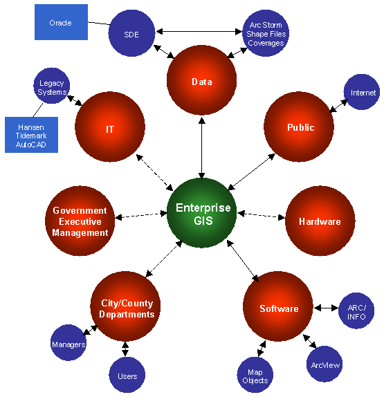
In January 1997, the City of Indianapolis/Marion County (City) signed a six-year agreement with Convergent Group affiliate UGC Consulting (UGC) to manage its GIS program. At that time, the City had invested heavily in GIS over a 10-year period and had less than 40 regular GIS users. The core usage was within a GIS group composed of eight individuals from various departments. The software, hardware, data, and people were in place for a citywide GIS; however, one of the lacking ingredients was the operational and management expertise needed to accomplish the goal of establishing an enterprise solution-the complexities of which are shown in Figure 1.
FIGURE 1 - Enterprise GIS Architecture
The first step in the development of an enterprise solution was to deploy GIS to the desktop and provide users with the tools to view the geographic information and perform analysis with the data. ArcView was the logical solution to provide this information to the users. However, ArcView, out of the box, had a large and steep learning curve, which was beyond the desires of the majority of the City employees. To simplify ArcView, a customized data browser was developed, along with a number of customized applications (snow removal, street cut permitting, customer service complaint tracking, street closure permitting, chuckhole tracking and management, polling place locator, map plotting wizard, zoning) and ArcView extensions (zoning analysis and advanced browser), to provide the users with the tools that they needed to perform GIS at their PCs. By the end of 1997, there were over 250 GIS users in the City. The City currently has 402 licenses of the software, and it is the largest user of ArcView in the Midwest region.
Establishing the Enterprise GIS Design Plan
The impetus to establish an enterprise GIS started at the executive level with a long-term vision shared by the Mayor and department directors. Given executive sponsorship, the next step was to develop a six-year strategic plan to serve as the blueprint for the implementation of an enterprisewide GIS. A vision for the development of "Enterprise GIS" was created, outlining a high-level strategy. The strategic direction of the GIS had to take into account not only what currently was occurring at the City, but had to be visionary enough to provide technological direction to fit the current administration's plans for information technology. The SIP was created to ensure actions would be carried out that would help to maintain this executive support.
Turning the Plan into Action
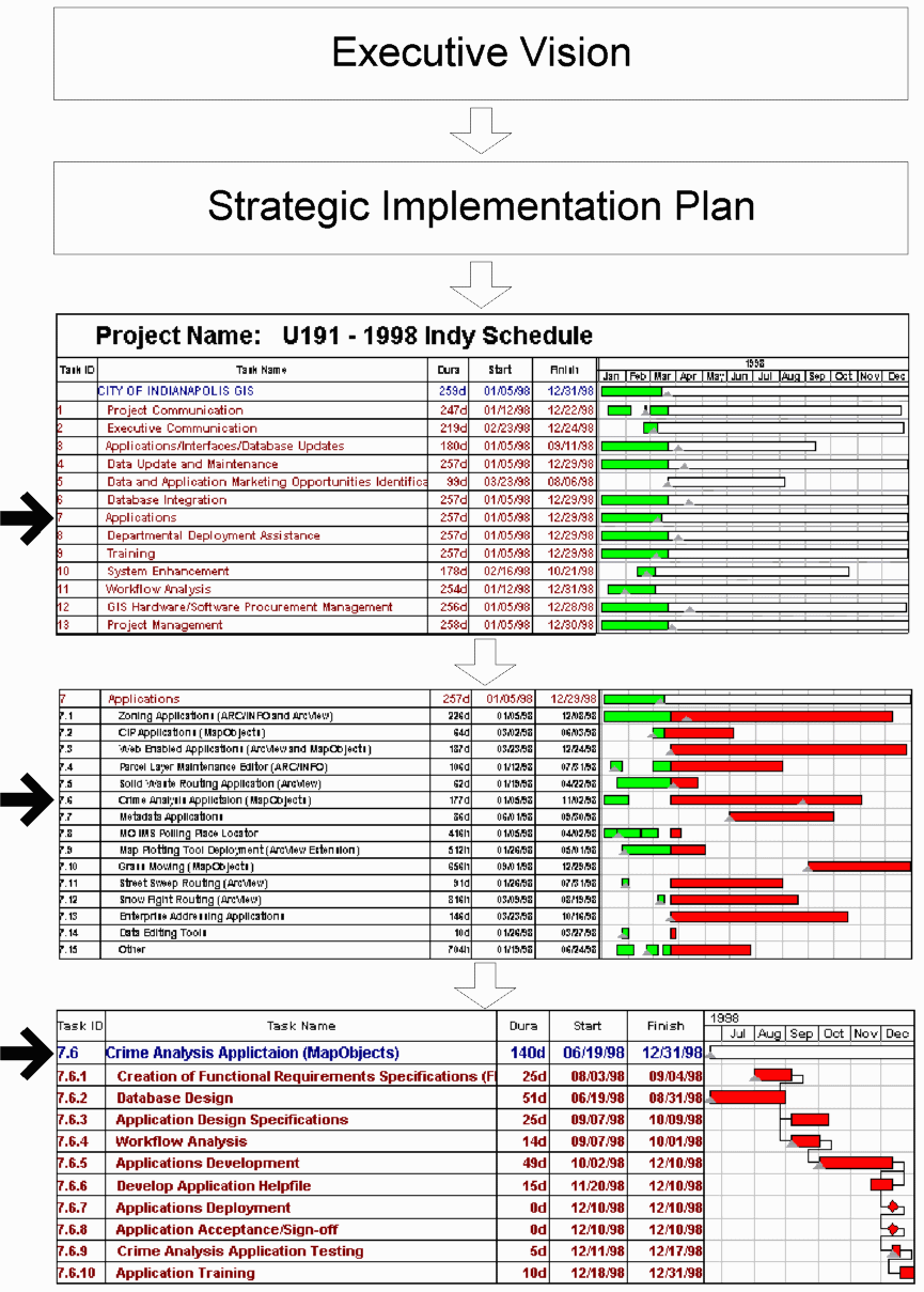
A six-year plan provides high-level direction, but to actually implement it, the plan must be broken down into tangible pieces. UGC worked with the City GIS staff to determine meaningful work tasks for the next year that were both consistent with the plan and the executive vision. Figure 2 illustrates how the vision was carried down from plan to task, and then to two levels of subtasks. Numerous application initiatives were identified for the 1998 calendar year, the second year of the six-year project. These initiatives were broken down into 13 primary tasks, and then into various subtasks. The project managers worked with GIS staff at both UGC and the City to determine which tasks individuals should be assigned. Using budgeted labor funds for the 1998 year of the project, time was then allocated for each individual to the appropriate tasks. The time duration for each task was determined based on individual input, comparing similar metrics from the year before, and on company metrics gleaned from having performed similar work on other projects. When close to being finalized, the schedule was then presented to project executives for their approval. With their approval, the proposed schedule became a reality, and a consensus on the project work tasks was achieved. The hard part would come next-sticking to the schedule.
FIGURE 2 - Project Breakdown
Using a Tool to Manage the Project (Time, Costs, and Resources)
UGC was tasked to manage and have complete responsibility of GIS operations for the City over a six-year time period. Project management of the schedule involves using project scheduling software [Project Scheduler (PS/7) from Scitor Corporation] to track the time and actions of 12 UGC staff and 8 City GIS employees. This situation provides an interesting challenge to the project management in that half of the Esri developers are in Denver, while the rest are in Indianapolis.
Each week all staff complete and submit a personal timesheet showing hours spent working on project-related tasks. The hours are entered into PS/7 each week and compared with project baseline estimates. Hours spent by the team working on tasks are compared with what the project baseline shows the team should have worked on for that week. Project managers in Denver and Indianapolis then work with individual team members to adjust either their work tasks (preferred) or to adjust the project schedule (not preferred, but sometimes unavoidable) to keep actual and predicted hours consistent on the schedule. PS/7 can generate a variety of products that help communicate to executives the status of various initiatives. Data on actual versus predicted hours, schedule variance, actual costs versus predicted costs, estimate of cost at completion, and percent complete can be generated easily and presented in any one of numerous canned reports to communicate status on an individual subtask, a task, or for the project as a whole (for that year). Tasks that have multiple year durations are rebaselined and rescheduled at the beginning of each year for simplicity (to help break a six-year project down into more manageable components).
It is important to note that with any schedule, the best predictions are never perfect. Adjustments to the schedule are necessary throughout the duration up until the very end. The schedule will not be 100 percent accurate until the project is complete at the end of each year. A successful schedule will usually need fewer adjustments at the end than at the beginning, meaning the time, cost, and resource estimates as the project nears completion will be most accurate when it counts most-near the end of the project when the pressure to deliver is greatest.
Communication Practices to Support the Plan
The best of plans can only go as far as the communication channels will carry it. Team members who comprise the plan, users who are impacted, and executives who are paying for it must all be kept informed of its merits at various stages along the way for the plan to be successful. Without proper communication, people are likely to come up with their own varying interpretations of what is in the plan and try and change it to support their views.
To ensure communication at the City of Indianapolis, several communication mechanisms are built into the plan (Task 1, Project Communication, and Task 2, Executive Communication). At the executive level, presentations to City Council are conducted twice a year to brief them on project accomplishments. An Executive Steering Committee was created with GIS project sponsors and department directors to discuss important strategic initiatives on a quarterly basis.
To encourage support from the users, the GIS team (City and UGC staff) gets together each quarter to present the latest accomplishments to the user community at large. Demonstrations of new applications, updates on data conversion, and other highlights from the use of GIS technology are part of the regular program that is presented. Attendance by City employees has been as high as 80 people at some of these briefings. A quarterly newsletter, entitled "GIS Enterprise," is circulated to users and potential users to keep GIS on everyone's mind. Mousepads have even been created and given to users showing screen shots of several applications. Articles are written about the project, and presentations at industry conferences are given, whenever the opportunity arises.
To maintain internal support for plan, UGC team members and City GIS staff conducted an off-site retreat in November to review what worked well from the previous plan and to discuss what should be changed in the new plan (the one developed for 1998). Team members are much more likely to support the plan when they actively participate in its creation. The team retreat also provided an opportunity to reaffirm the executive vision and review the strategic implementation plan.
Conclusion
The City of Indianapolis/Marion County has been successful in turning an executive vision into an enterprise GIS reality in part due to the organization having strong project management practices. Project management tools can help communities achieve their GIS objectives by helping participants to better understand and realize the steps involved in obtaining these goals. The implementation of this tool, however, must coincide with sound communication practices to be successful. Although sometimes difficult to implement, the time spent learning how to use a project schedule tool and communicating its contents will more than justify itself in the long run by helping to build consensus among team members, secure support from project executives, and assist the project manager in understanding whether the combination of time, costs, and resources are headed in a direction that will make the GIS project successful.
Patrick J. Noonan
Senior Technical Consultant
Convergent Group
6200 South Syracuse Way
Suite 200
Englewood, CO 80111
303-741-8400 (phone)
303-741-8401 (fax)
pnoonan@cvg-grp.com
http://www.convergentgroup.com
David P. Mockert
Technical Consultant
Convergent Group
6200 South Syracuse Way
Suite 200
Englewood, CO 80111
303-741-8400 (phone)
303-741-8401 (fax)
dmockert@cvg-grp.com
http://www.convergentgroup.com