William H. Nuckols III
University of Charleston
Charleston, SC
Improving Coastal Management Decisions Using a GIS and NMFS Survey Data
Abstract
Absence of long-term, fishery-independent data on fish and shellfish abundance is common when trying to direct activities toward or away from areas of important fish and shellfish habitat. This project illustrates how this difficulty may be overcome using a geographic information system (GIS) and a database assembled by the National Marine Fisheries Service (NMFS). Records 3,712 tows, conducted between the fall of 1981 and spring of 1992, from the NMFS groundfish, surf clam/ocean quahog, and sea scallop survey programs were filtered and plotted using a GIS to indicate areas of important habitat in the New York Bight. Conclusions drawn from the data were applied to a particular coastal management problem - the siting of a dredge material containment island or disposal pit.
Keywords: habitat, GIS, groundfish, shellfish
Introduction
Coastal managers often try to direct activities (e.g., locating a new marine sanctuary, developing offshore oil and gas wells, designating sewage outfalls or ocean disposal sites) toward or away from areas where the abundance of fish or shellfish is high. The absence of long-term, fishery-independent data on fish and shellfish abundance is often a problem when making these decisions. This difficulty may be overcome using a geographic information system (GIS) and a database assembled by the National Marine Fisheries Service (NMFS) that is commonly used for fish stock assessments.
The Port of New York and New Jersey has an ongoing need to maintain the current depths of its channels and berthing areas. The Port Authority of New York/New Jersey is also interested in further deepening the Harbor channels, making the New York/New Jersey port more competitive with the ports of Baltimore, Maryland and Norfolk, Virginia, which are able to service the new generation of deep draft container ships. Polluted sediments in the Harbor have precluded open ocean disposal of dredged sediments due to concerns over impacts on the biota of the New York Bight.
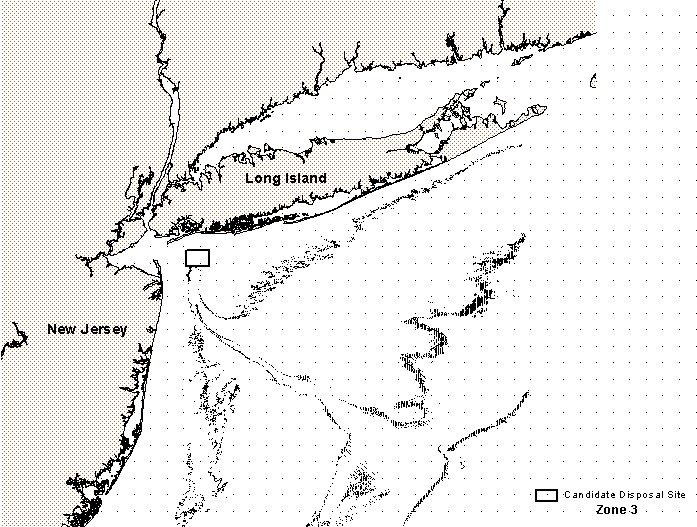
Containment islands and disposal pits were under consideration in the 1996 Dredged Material Management Plan (DMMP) as a potential solution to the problem of dredge material disposal. Three locations are being examined for siting a disposal island or pit. Two sites are in the New York/New Jersey Harbor, and the third candidate disposal location (Figure 1-7), referred to as "Zone 3" in the DMMP, is located in the New York Bight.
Methods
NMFS Database:
Since the 1960�s, NMFS has regularly sampled for groundfish and shellfish off the eastern coast of the U.S. between Cape Hatteras, NC, and Canada (Azarovitz et al., 1985). The groundfish surveys typically used a 36-ft Yankee otter trawl, the surf clam/ocean quahog surveys used a hydraulic jet dredge equipped with a 5-ft wide blade and submersible pump, and the sea scallop surveys used an 8-ft New Bedford type scallop dredge. Survey efforts followed a stratified random sampling design that use depth and bottom type to define strata. Large strata were further subdivided into 5- by 10-minute cells, and small strata were subdivided into 2.5- by 2-minute cells. Tow origins were randomly chosen from the cells within each stratum. The number of cells within a stratum sampled per season was roughly proportional to the area of the stratum, and each stratum was usually sampled during the spring and fall of each year. Tows were standardized by time.
Identification of Import Areas
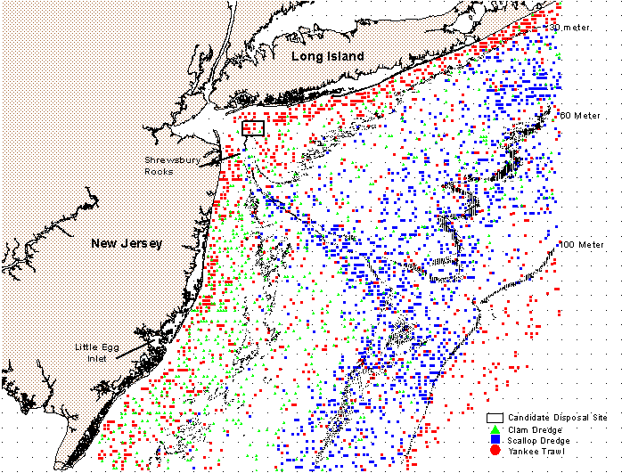
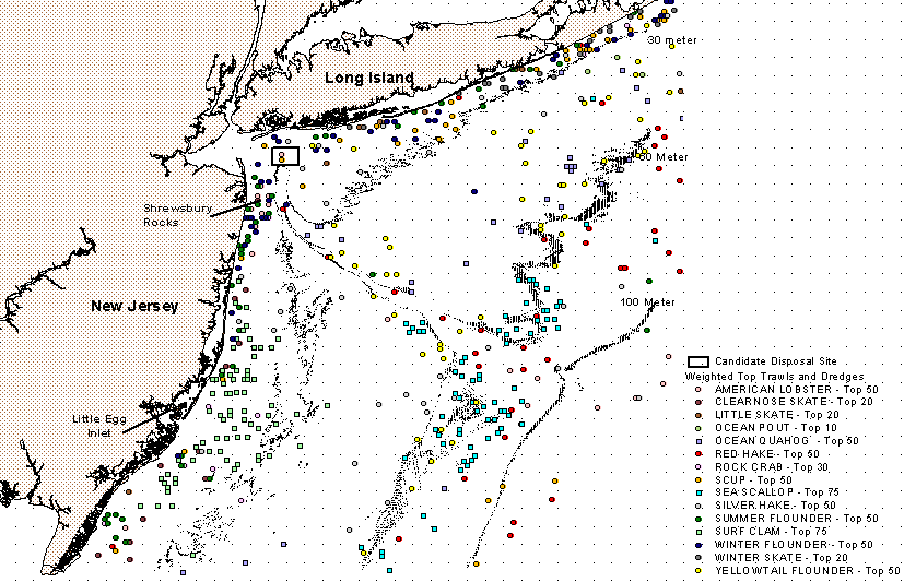
Records were obtained from 3,712 tows of the NMFS groundfish, surf clam/ocean quahog, and sea scallop survey programs, conducted between the fall of 1981 and spring of 1992 (Figure 1). Species vulnerable to the collection gear and collected in sufficient numbers to be included in this study are included in Table 1.
Table 1.
| COMMON NAME | SCIENTIFIC NAME | GEAR | Dollars |
| Sea Scallop | Placopecten magellanicus | Sea Scallop Dredge | 336,451,270 |
| American Lobster | Homarus americanus | Yankee Trawl | 57,509,598 |
| Summer Flounder | Paralichthys dentatus | Yankee Trawl | 48,026,717 |
| Silver Hake | Merluccius bilinearis | Yankee Trawl | 35,439,634 |
| Ocean Quahog | Arctica islandica | Surf Clam Dredge | 32,677,221 |
| Scup (Porgy) | Stenotomus chrysops | Yankee Trawl | 24,338,636 |
| Atlantic Surf Clam | Spisula solidissima | Surf Clam Dredge | 24,194,043 |
| Yellowtail Flounder | Limanda ferruginea | Yankee Trawl | 10,149,342 |
| Winter Flounder | Pseudopleuronectes american | Yankee Trawl | 4,626,301 |
| Red Hake | Urophycis chuss | Yankee Trawl | 2,520,822 |
| Rock Crab | Cancer spp. | Yankee Trawl | 356,217 |
| Winter Skate | Raja ocellata | Yankee Trawl | 199,813 |
| Little Skate | Raja erinacea | Yankee Trawl | with above |
| Clearnose scate | Raja eglanteria | Yankee Trawl | with above |
| Ocean Pout | Macrozoarces americanus | Yankee Trawl | 20,529 |
| Haddock | Melanogrammus aeglefinus | Yankee Trawl | 9,566 |
Relative abundance and economic value of the tows were used to identify the relative importance of areas within the Bight as fish or shellfish habitat. A GIS was used to filter and display the data.
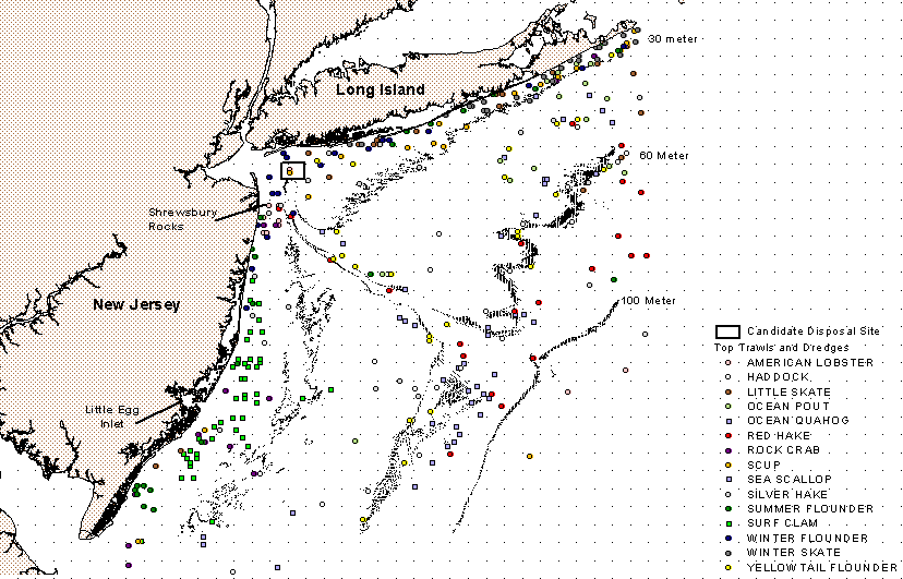
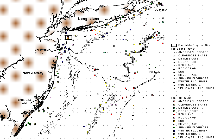
In the first examination of the data, all species represented in the data were given equal weight. The top 25 tows for each species were plotted in Figure 2. In Figure 3, Yankee otter trawl data were separated into spring (March-April) and fall (September-October) tows. The top 12 spring and top 12 fall trawls are plotted to account for seasonal variation in areas utilized by groundfish.
In recognition of the economic importance of some species over others, the top tows from each species are plotted (Figure 4), but with the number of tows scaled, based on commercial landings (Table 1). For example, ocean pout has the lowest commercial value and was arbitrarily set at 10 points. Sea scallops, which have 35K times the value of ocean pout, was plotted with 75 points. Commercial landings were obtained from the NMFS Fisheries Statistics Division by water code for the NY Bight for years 1980 to 1994 (Sutherland, personal communication). New York Bight commercial landings values are for federal waters only and do not include catches from bays and waters within three nautical miles of shore.
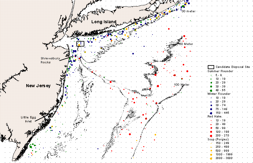
Figure 5 indicates the distribution of groundfish species that were both highly targeted by recreational anglers, as determined by the 1994 Northeast Region Marine Recreational Economics Survey (Steinback, in press), and were well represented in the NMFS database.
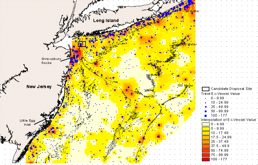
To compare catch from any particular location, the commercial value of the survey trawl was plotted (Figure 6). To determine the commercial value of a trawl tow, the average weight of each fish species, lobster or crab was multiplied by commercial ex-vessel value, an average of the values for New York and New Jersey, for the year landed. These values were then summed for all the species caught in that particular trawl tow.
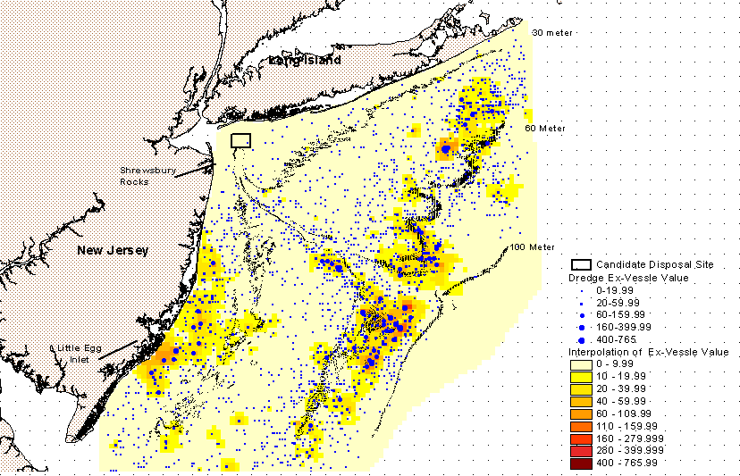
A slightly different procedure was used for dredge tows because the NMFS survey records did not include weights for sea scallops, ocean quahogs, and surf clams. Average meat weight for ocean quahogs was used from Long Island and New Jersey samples taken in 1978 (Mrawski and Serchuk, 1979). Average meat weights for recruits and fully recruited surf clams for 1980 to 1992 were reported in the 22nd Northeast Regional Stock Assessment Workshop (Northeast Fisheries Science Center, 1996). The weight used for surf clam commercial value was the result of the average weights of these two classes applied at the ratio of recruits to fully recruited surf clams presented in the surf clam stock assessment (Northeast Fisheries Science Center, 1996).
In a study by Lai (1997), sea scallop average shell length was measured and meat weight derived from a shell length to meat weight ratio determined in population studies at the NMFS Northeast Fisheries Science Center. The calculated average weight from 1981 to 1992 samples from the New York Bight was applied by year to the NMFS scallop survey catch numbers to generate total scallop weight for each tow. Drained meat weights for shellfish were then multiplied by commercial ex-vessel value, from the NMFS Commercial Fisheries website (December 30, 1996), for that year.
Esri Arcview Spatial Analyst was used to generate an inverse distance weighted interpolation of the commercial values for groundfish (Figure 6) and shellfish (Figure 7). A graduated symbol plot was laid over the interpolation to illustrate the individual tow values (Figures 6 and 7).
Conclusions
From the patterns common to several or all of the figures from the GIS, general conclusions on important habitat were drawn. Tows from areas in water 30 meters or less typically catch more fish, lobsters and crabs than tows from deeper areas. Sea scallops are concentrated near the 60 meter contour as it extends offshore and along the canyon. Surf clams were concentrated landward of the 30 meter contour off of the coast of New Jersey. The area immediately southeast of Little Egg Inlet is an area of importance to surf clams and groundfish. Shrewberry Rocks is a hardbottom area which is important for groundfish and American lobster. Major topographic breaks, such as the edges of the Hudson Shelf Canyon are important for groundfish.
Conclusions on habitat importance were based solely on the data from the 1981-1992 NMFS survey data sets. Due to the selective nature of the gears used, particularly the Yankee otter trawl, several species which are important to the Bight were not examined. Important recreational species, tautog (Tautoga onitis) and black sea bass (Centropristis striata), were not present in the data due to their preference for rocky bottom. Atlantic Cod (Gadus morhua) and Goosefish (Lophius americanus), commercially important species, were also not collected in sufficient numbers to be included in the GIS analysis.
Using identification of important habitat identification while addressing a coastal management problem:
To illustrate how these NMFS survey data may be used, conclusions on important areas have been applied to a particular management decision. The U.S. Army Corps of Engineers (USACE) requires each Corps district office to prepare a long-term plan for maintaining federal navigation channels. The 1996 interm report on the Derdged Material Management Plan emphasized the economic imperative of dredging the naturally shallow areas of the Port, and the urgency of implementing an environmentally suitable disposal plan. Over 24 million cubic yards of material is projected to be dredged over the next five years alone. Several groups are proposing consideration of an area east of the harbor mouth (shown as the candidate disposal site in Figures 1-7) as a disposal site for dredged material. A containment island or disposal pit large enough to handle the volume of material generated by the Corps dredging activities will have a large impact on the biota in this area. The NMFS survey data show that the proposal to use this area should be carefully considered. Eleven of the twelve survey stations within the proposed disposal area were among the tows with highest abundance or ex-vessel value in the groundfish and shellfish surveys.
The GIS output needs to be interpreted at a scale appropriate to the NMFS data set. The NMFS survey data are not well suited for siting models that are trying to select exactly where a facility might be located to minimize habitat impacts. However, avoiding important habitat, defined by general conclusions on the importance of coastal waters less than 30 meters in depth and hard bottom areas, such as Shrewsburry Rocks, may lessen the impact on groundfish and shellfish resources.
Acknowledgments
This research was conducted through a NOAA Sea Grant internship program with the National Oceanographic and Atmospheric Administration (NOAA) Coastal Services Center. I would like to thank the NOAA Coastal Services Center and the U.S. Army Corps of Engineers, New York District Office, for their technical and financial support.
Citations
Azarovitz, T.R., Byrne, C.J., Pritchard, E.S., Despres-Patabjo, L.I., Foster, H.A. and Wilk, S.J. (January) 1985. Distribution and abundance trends of 22 selected species in the Middle Atlantic bight from the bottom trawl surveys during 1967-1979. Final Report to the U.S. Minerals Management Service (Contract No. AA 550-1A7-35) by the National marine Fisheries Service, Northeast Fisheries Science Center, Woods Hole, MA. 569 pp.
Lai, H.L. and L. Hendrikson. 1997. Current resource conditions in USA Georges Bank and Mid-Atlantic sea scallop populations: Results of the 1996 NMFS sea scallop research vessel survey. NEFSC Ref. Doc. 97-xx (in press).
Murawski, S. A., and F. M. Serchuk. 1979. Shell length-meat weight relationships of ocean quahogs, Arctica islandica, from the middle Atlantic shelf. Proceedings of the National Shellfisheries Association 69:40-46.
Northeast Fisheries Science Center. 1996. Report of the 22nd Northeast Regional Stock Assessment Workshop (22nd SAW): Stock Assessment Review Committee (SARC) consensus summary of assessments. Northeast Fish. Sci. Cent. Ref. Doc. 96-13; 242p.
National Marine Fisheries Service, Fisheries Statistics & Economics Division. "COMMERCIAL FISHERIES STATISTICS". (30 Dec. 1996).
Steinback, Scott. Summary Report of Methods and Descriptive Statistics for the 1994 Northeast Regional Marine Recreational Economics Survey. NOAA Technical Memorandum, NMFS-NEFSC, in-press.
Sutherland, David. Email communication, April 24, 1997.
U.S. Army Corps of Engineers New York District. Dredged Material Management Plan for the Port of New York and New Jersey, Interim Report. September 1996.
William H. Nuckols III
University of Charleston, South Carolina
1492 Kentwood Circle Charleston, SC 29412
843-406-7901
email: nuckolsw@atrium.musc.edu
Alternate email: wnuckols@csc.noaa.gov
Alternate contact address:
1000 77th Street Newport News, VA 23605
757-826-8313