Mohan Balagopalan
Communication of Health Risk Assessment by Integrating Geographic Information System (GIS) with Computer Dispersion Models
Abstract
Communication of the impacts of air pollution from industrial sources which may cause cancer and acute and chronic health effects is one of the greatest challenges faced by a risk manager. How the information is presented to the affected public is as important as the discussions on the health impact of the chemicals released routinely or accidentally into the environment. This paper will deal with the integration of GIS with a computer dispersion-modeling program to communicate effectively the magnitude and extent of the impact of air pollution on the community from industrial sources.
On December 3, 1984, at the Union Carbide plant in Bhopal, India, a cloud of methyl isocyanate (MIC) gas, an extremely toxic gas, was released from their storage tanks, resulting in exposures to the community downwind from the plant with dire consequences. A significant number of the residents of Bhopal who lived downwind from the plant died and continue to do so and there are also a significant number still suffering from the aftermath of the incident.
The disastrous incident set the impetus for the development of a number of community-right-to-know regulations in this country at the federal, state and local government levels and the reassessment by industrial facilities of their operations. In addition, citizens' groups joined forces to pass legislation (e.g., Proposition 65 in California) mandating that industries disclose the hazards they pose and to communicate the risks of excess cancer and non-cancer health effects to the affected communities. The ensuing regulations required public communication of the adverse health impact and risks from routine or daily operation of the industrial facilities neighborhood by neighborhood. They were also required to anticipate worst-case (Bhopal type) scenario or a potential accidental event.
In California, the State legislature passed the Air Toxics "Hot Spots" Information and Assessment Act of 19871 (Assembly Bill 2588). This established a statewide program for the inventory of air toxics emissions from individual facilities as well as requirements for risk assessment and public notification of potential health risks. The state Legislature found and declared (California Health and Safety Code 44300 et.seq) that:
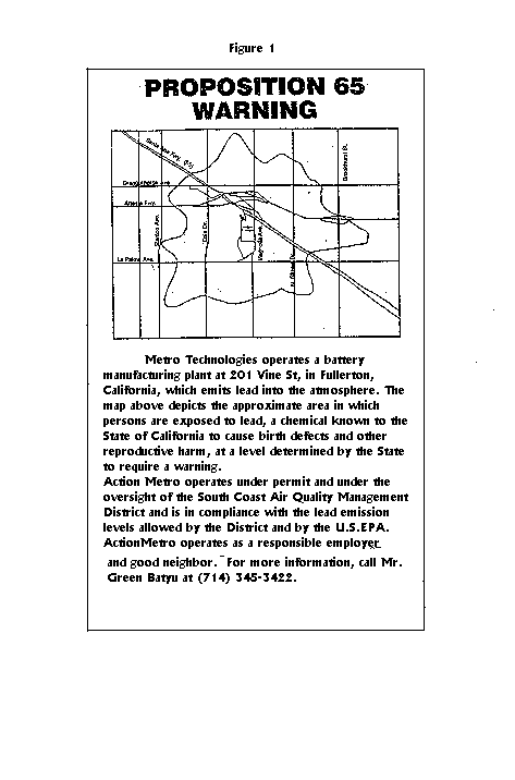
In November 1986, California voters approved an initiative to address growing concerns about exposures to toxic chemicals. That initiative became The Safe Drinking Water and Toxic Enforcement Act of 1986, better known by its original name: Proposition 65. One of the requirements of the Proposition 65 is the posting of warning in either written, printed or in a graphic manner that indicates the "affected area" from the release of the chemicals above the threshold levels identified in the Act. A typical posting for Proposition 65 is shown in Figure 1.
The Emergency Planning and Community Right to Know Act, also known as the "Bhopal" legislation was passed by Congress in 1986 and was designed to inform communities about the potential threats in their midst.
The Federal Accidental Release Prevention Program [Title 40, Code of Federal Regulations (CFR) part 68] was developed to require facilities that handle regulated substances in quantities exceeding specified thresholds, to prepare a hazard assessment and submit a risk management plan (RMP). The RMP is part of the their risk management programs to prevent the accidental release of regulated substances. One of the requirements of the hazard assessment is the identification of geographic areas most vulnerable to hazardous release events (worst-case accidental releases, potential offsite consequences of releases or other alternate release scenario) so that the potential impacts can be quantified. The RMP becomes a public document once it is submitted to the federal, state and local administering agencies and will be used for communicating the offsite consequences to the public.
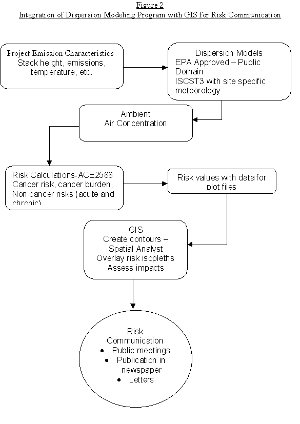
A requirement in all these federal, state and local regulations is risk communication. A number of computer models and programs are available as tools to assist a risk manager in communicating risk to the public. This paper discusses the integration of computer dispersion modeling software with ArcView with the Spatial Analyst extension to overlay risk isopleths to show cumulative impacts on the community. The steps involved in the integration of GIS with computer dispersion model for risk communication is shown in Figure 2.
The preferred dispersion modeling program recommended by the Environmental Protection Agency (EPA) for industrial sources is Industrial Source Complex Short Term (ISCST3)2. This dispersion model is used to calculate concentration or deposition values for different averaging time periods at pre-defined receptors areas in the ambient air from the release of pollutants from a single or a multiple of sources (point, volume, area) with actual site specific pre-processed meteorological information. The dispersion model is a Gaussian model that assumes the releases from the sources occur in a steady state manner from the time of release until it reaches the receptors.
The output from the dispersion model is ground level concentration values at the desired or specified receptors for the averaging hours (1 hour, 6 hours, 24 hours, annual, etc.) specified. From this data, a concentration isopleth can be drawn for sources that have the same concentrations. Most of the software packages available either in the public domain or from the private sectors create a plot file for concentrations. However, to calculate the risk from the pollutants emitted from the source, the concentration values would have to be multiplied with the potency factors for the pollutants emitted and the risk adjusted if the pollutants have multiple routes of exposures.
The ISC3 model is a steady-state Gaussian plume model which can be used to assess pollutant concentrations from a wide variety of sources associated with an industrial source complex. The model is recommended for:
The input requirements for the source data are the following:
Optional inputs include:
ISCS3 requires pre-processed hourly weather data that includes stability class, wind direction, wind speed, temperature, and mixing height.
Output Data
The output file gives the concentration or deposition values for each identified receptor for the specified averaging hours within the specified meteorological period. The output for plot files and partial contribution files can also be specified in the program. The partial contribution file (pcon.bin) contains the relative contribution for the concentration for the averaging time from each source based on an emission rate of 1 gm/sec.
The health risk assessment is a detailed comprehensive analysis prepared to evaluate and predict the dispersion of hazardous substances in the environment and the potential for exposure to human populations and to assess and quantify both the individual and population-wide health risks associated with those levels of exposure (H&S 44306). The risk assessment shall consider the potency, toxicity, quantity, and volume of hazardous materials released from the facility, the proximity of the facility to potential receptors, including, but not limited to, hospitals, schools, day care centers, worksites, and residences. Figure 3 shows a Summary Health Risk Assessment Form that shows the maximum risk, the pollutants that contribute to the risk, and the location of the maximum risk receptor.
The California Air Pollution Control Officers Association (CAPCOA) published the Air Toxics "Hot Spots" Program Risk Assessment Guidelines3 in 1991 and was revised in 1993. A program, Assessment of Chemical Exposure for AB 2588 (ACE2588) was designed for AB2588 risk assessments, and it incorporates the algorithms and recommendations in the CAPCOA's Risk Assessment Guidelines.
The ACE2588 model interfaces with ISCST3 to predict ambient air concentrations, and to assess the exposure to and associated risks of toxic pollutants emitted from a single or multiple sources in a facility. The program also calculates risk from other exposure pathways such as dermal, soil, water, food and mother's milk.
Currently the California Air Resources Board is developing an integrated program Hot Spot Analysis and Reporting Program (HARP) that will integrate the modeling program (ISCST), the health risk assessment program (HRA) and GIS. A number of consulting companies4 have developed modeling programs which have integrated GIS with the output of dispersion modeling.
Figure 3
HEALTH RISK ASSESSMENT SUMMARY FORM
(Required in Executive Summary of HRA)
Company Name _Carthage Anodizing Inc______________________
Facility Name _ __________________________
Facility Address _400 E. Cloaks St____________________________________
_Compton, CA 90222___________________________________
AQMD ID Numbers _A49384___
A. CANCER RISK
1. Inventory Report Basis 1989 Curent emissions
(circle one only)
2. Maximum Cancer Risk to Receptors (based on Tables III-5* and III-6* substances)
a. Max Offsite _______35.6 x 10-6___ location:_387,548E; 3,752,639N
b. Residence _______35.6 x 10-6___ location:_387,548E; _3,752,639N
c. Worker ________8.8 x 10-6_ location:_387,348E; 3,752,739N
3. Substances Accounting for 90% of Cancer Risk _hexavalent chromium______
Processes Accounting for 90% of Cancer Risk __chrome anodizing__________
4. Population Exposed to Specific Risk Levels (including worker population)
a. >1x10⁻⁶ __15,820________
b. 1x10⁻⁶ to 1x10⁻⁵ __ 15,370________
c. 1x10⁻⁵ to 1x10⁻⁴ ___ 450_______
d. 1x10⁻⁴ to 1x10⁻³ __________
e. >1x10⁻³ __________
5. Cancer Burden __0.046________ (including worker population)
6. Maximum Distance to Edge of 1 x 10⁻⁶ Cancer Risk Isopleth (meters) 1500______
7. Screening Cancer Risk to Most Exposed Individual (based on Table III-7* substances)
a. Residence (without silica) ____________________
b. Residence (silica only) ____________________
B. HAZARD INDICES **
1. Highest Chronic Hazard Indices (based on Tables III-8* and III-10* substances)
Residential chronic HI: Liver__ toxicological endpoint:_0.2534
Worker chronic HI: _______ toxicological endpoint:_______________
2. Substances Accounting for 90% of Chronic Hazard Index: Cr +6, 1-1-1 TCA
Processes Accounting for 90% of Chronic Hazard Index _chrome anodizing, degreaser
3. Highest Acute Hazard Indices (based on Table III-9* substances)
Residential acute HI: _CNS_____ toxicological endpoint: _0.0028_______
Worker acute HI: _________ toxicological endpoint: ______________
4. Substances Accounting for 90% of Acute Hazard Index _111-TCA_____________
Processes Accounting for 90% of Acute Hazard Index __Degreaser__________
* CAPCOA Air Toxics "Hot Spots" Program Risk Assessment Guidelines, October 1993
** Provide Tables listing contribution of each substance to Chronic HI and/or Acute HI.
The following steps were taken to create the risk isopleths to show cumulative impacts.
To show the cumulative effects of two nearby sources on the same receptor locations, two modeling runs and health risk assessment were conducted. The input data for the sources were assumed to be identical, with the same source parameters and emission rates, except for their location. The model runs were based on five sources: 3 points and 2 volume sources, 5 pollutants, 112 receptors, and meteorological data for the City of Compton, California, for 365 days. The concentrations for 1-hour maximum and the annual average were generated for each receptor.
The input file was prepared in the format required to run ISCST3 by using a text editor. Programs with front-end interfaces create the input file in the required format for the model. One such program developed by EPA is EXINTER 5 (expert interface). Programs in the public domain all have user friendly front-end interfaces which prepare the input file to run the model.
To run the model, the source data, source location, emission data, receptor data, site specific meteorological data from the closest air monitoring station, receptor data, and emission data are needed. Figure 4 shows the various inputs needed for the model run.
The input file that was generated to run ISCST3 for one of the sources is as shown in Table 1. A partial listing of the output file from ISCST3 is as shown in Table 2. The output file generates the partial contribution file (pcon.bin) for further processing in ACE 2588. Table 2 shows the some receptors points with their concentration levels. The ACE2588 reads the pcon.bin file to calculate the cancer risk, cancer burden and non-cancer health effects.
To run ACE2588, the input file as shown in Table 3 was prepared in the required format. This input file identifies the number of receptors, number of sources, hours of model runs and number of days. In addition, the pollutant IDs' are identified as well as the actual emission rates and the receptor locations where the risk values are to be calculated.
Figure 4
Model Inputs Required for ISCST3
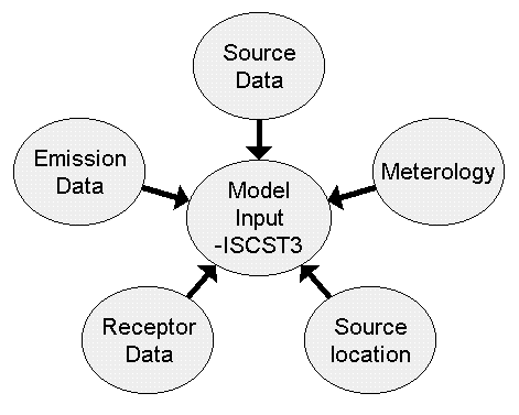
Table 1
Input File for ISCST3
CO STARTING
CO TITLEONE Carthage Anodizing 8/05/99
CO MODELOPT CONC URBAN NOCALM
CO AVERTIME PERIOD 1
CO POLLUTID OTHER
CO DCAYCOEF .000000
CO RUNORNOT RUN
CO ERRORFIL ERRORS.OUT
CO FINISHED
SO STARTING
** Source Location Cards:
** resource recovery unit/boiler stack
** SRCID SRCTYP XS YS ZS
SO LOCATION 1 POINT 387448. 3752636. 0.0
SO LOCATION 2 POINT 387469. 3752687. 0.0
SO LOCATION 3 VOLUME 387465. 3752648. 0.0
SO LOCATION 4 VOLUME 387471. 3752649. 0.0
SO LOCATION 5 POINT 387446. 3752661. 0.0
** Source Parameter Cards:
** POINT: SRCID QS HS TS VS DS
** VOLUME: SRCID QS HS SYINIT SZINIT
** AREA: SRCID QS HS XINIT
**(QS=emission rate; HS= stack height; TS=stack temperature;VS= stack velocity;DS= stack diameter)
SO SRCPARAM 1 1.0000000 9.15 294.000 8.1300 0.9100
SO SRCPARAM 2 1.0000000 9.15 294.000 8.8900 0.9100
SO SRCPARAM 3 1.0000000 1.83 9.30 1.70
SO SRCPARAM 4 1.00 1.83 9.30 1.70
SO SRCPARAM 5 1.00 9.15 294.000 9.31 0.25
*Emission rate: *
SO EMISUNIT .100000E+07 (GRAMS/SEC) (MICROGRAMS/CUBIC-METER)
SO SRCGROUP 1 1
SO SRCGROUP 2 2
SO SRCGROUP 3 3
SO SRCGROUP 4 4
SO SRCGROUP 5 5
SO FINISHED
**Discrete Receptors Location**
RE STARTING
RE DISCCART 387348. 3752739.
RE DISCCART 387348. 3752639.
RE DISCCART 387348. 3752539.
RE DISCCART 387448. 3752739.
RE DISCCART 387448. 3752539.
RE DISCCART 387548. 3752739.
RE DISCCART 387548 3752639.
RE FINISHED
**Meterology Data**
ME STARTING
ME INPUTFIL COMPTON.asc
ME ANEMHGHT 10.000 METERS
ME SURFDATA 53112 1981 SURFNAME
ME UAIRDATA 91919 1981 UAIRNAME
ME STARTEND 81 01 01 81 12 31
ME FINISHED
**Output**
OU STARTING
OU RECTABLE ALLAVE FIRST
OU POSTFILE 1 1 UNFORM pcon.bin 20
OU POSTFILE 1 2 UNFORM pcon.bin 20
OU POSTFILE 1 3 UNFORM pcon.bin 20
OU POSTFILE 1 4 UNFORM pcon.bin 20
OU POSTFILE 1 5 UNFORM pcon.bin 20
OU POSTFILE PERIOD 1 UNFORM pcon.bin 20
OU POSTFILE PERIOD 2 UNFORM pcon.bin 20
OU POSTFILE PERIOD 3 UNFORM pcon.bin 20
OU POSTFILE PERIOD 4 UNFORM pcon.bin 20
OU POSTFILE PERIOD 5 UNFORM pcon.bin 20
OU FINISHED
Table 2
ISCST3 Output File
ISCST3 PARTIAL OUTPUT FILE -PCON.BIN FORMAT
*** ISCST3 - VERSION 97363 *** *** - 8/06/99 ***
PAGE 9
**MODELOPTIONS: CONCENTRATION; URBAN; FLAT; NOCALM WIND SPEED
*** THE PERIOD ( 8760 HRS) AVERAGE CONCENTRATION VALUES FOR SOURCE GROUP: 1 ***
INCLUDING SOURCE(S): 1 ,
*** DISCRETE CARTESIAN RECEPTOR POINTS ***
** CONCENTRATION OF OTHER IN (MICROGRAMS/CUBIC-METER) **
Receptors and Concentration Values
|
X-COORDINATES (M) |
Y-COORDINATES (M) |
CONCENTRATION |
|
387348.00 |
3752739.00 |
8.58361 |
|
387348.00 |
3752539.00 |
4.86830 |
|
387448.00 |
3752539.00 |
4.49750 |
|
387548.00 |
3752639.00 |
36.32518 |
|
386948.00 |
3753139.00 |
1.56062 |
|
386948.00 |
3752639.00 |
3.65352 |
|
386948.00 |
3752139.00 |
1.65675 |
|
387198.00 |
3752889.00 |
4.28041 |
|
387198.00 |
3752389.00 |
3.96668 |
|
387448.00 |
3753139.00 |
1.20004 |
|
387448.00 |
3752389.00 |
6.27417 |
The output from the modeling program is either a concentration or a deposition rate based on the emission rate entered. The concentration values have to be multiplied with the unit risk factor, or potency factor to obtain the cancer and non-cancer risk values and also have to be adjusted for different routes of exposures. For a single pollutant, this can be done easily in a spreadsheet program. However, the complexity adds up when there are multiple pollutants with different emission rates with different routes of exposures. Programs such as ACE 2588, the Health Risk Assessment (HRA) program or the Hot Spot Analysis and Reporting Program (HARP) available from the California Air Resources Board make the task much simpler.
The ACE2588 program is used to calculate the cancer risk from both inhalation and non-inhalation pathways, cancer burden, health hazard index for acute and chronic effects for multiple pollutants with different emission rates at each receptor location and to take into account multiple exposure routes. Samples of input and output files from ACE2588 are shown in Table 3 and 4. The data from Tables 4 and 5 are combined later in Excel and connected to ArcView to grid the receptor areas and plot the risk contours.
Table 3
Sample Input Format File for ACE2588
Input Format for ACE 2588
ACE2588 RUN FOR Carthage Anodizing Inc, Compton(7/28/99)
1 0 1 1 112 05 05 8760 365 **(information on number of receptors, pollutants, number of sources, hours of model runs and days)**
64 36 91 151 22 **pollutant ID:EGBE,Chromium, 1-1-1TCA,Xylene,Cadmium**
*Actual emission rate from the sources*
1 8760 1. 1. Spray Booth (Front Painting)
0.008 0.140e-5 0.16 0.005 0.0
0.006 1.200e-6 0.13 0.004 0.0
2 8760 1. 1. Spray Booth (Back Painting)
0.005 0.100e-5 0.107 0.003 0.0
0.004 0.800e-6 0.08 0.0027 0.0
3 8760 1. 1. Degreaser
0.00 0.00 0.24 0.00 0.0
0.00 0.00 0.19 0.00 0.0
4 8760 1. 1. Cadmium Plating
0.00 0.00 0.00 0.00 0.0
0.00 0.00 0.00 0.00 0.0
5 8760 1. 1. Chrome Anodizing
0.00 0.470e-5 0.00 0.00 0.0
0.00 0.370e-5 0.00 0.00 0.0
0.
0.
**Receptor location and population in receptor**
387348.0 3752739.0 .0 40.0 .1 .0R1
387348.0 3752639.0 .0 40.0 .1 .0R2
387348.0 3752539.0 .0 40.0 .1 .0R3
387448.0 3752739.0 .0 40.0 .1 .0R4
387448.0 3752539.0 .0 40.0 .1 .0R5
387548.0 3752739.0 .0 40.0 .1 .0R6
387548.0 3752639.0 .0 40.0 .1 .Primary school
387548.0 3752539.0 .0 40.0 .1 .0R8
386948.0 3753139.0 .0 250.0 .1 .0R9
386948.0 3752889.0 .0 250.0 .1 .0R10
386948.0 3752639.0 .0 250.0 .1 .0R11
386948.0 3752389.0 .0 250.0 .1 .0R12
0
Table 4
Health Risk Assessment Output File-ACE2588 output
|
RECEPTOR |
INHALE |
DERMAL |
SOIL |
WATER |
PLANT |
ANIMAL |
MOTHER MILK |
SUM |
POP |
BURDEN |
|
1 |
1.33E-05 |
2.19E-08 |
1.04E-07 |
0.00E+00 |
4.35E-08 |
0.00E+00 |
0.00E+00 |
1.34E-05 |
40 |
5.35E-04 |
|
2 |
1.23E-05 |
2.04E-08 |
9.62E-08 |
0.00E+00 |
4.04E-08 |
0.00E+00 |
0.00E+00 |
1.25E-05 |
40 |
4.98E-04 |
|
3 |
8.27E-06 |
1.37E-08 |
6.46E-08 |
0.00E+00 |
2.71E-08 |
0.00E+00 |
0.00E+00 |
8.37E-06 |
40 |
3.34E-04 |
|
4 |
1.02E-05 |
1.69E-08 |
7.96E-08 |
0.00E+00 |
3.35E-08 |
0.00E+00 |
0.00E+00 |
1.03E-05 |
40 |
4.12E-04 |
|
5 |
1.02E-05 |
1.69E-08 |
7.96E-08 |
0.00E+00 |
3.34E-08 |
0.00E+00 |
0.00E+00 |
1.03E-05 |
40 |
4.12E-04 |
|
6 |
7.58E-06 |
1.25E-08 |
5.91E-08 |
0.00E+00 |
2.48E-08 |
0.00E+00 |
0.00E+00 |
7.67E-06 |
40 |
3.06E-04 |
|
7 |
3.52E-05 |
5.81E-08 |
2.75E-07 |
0.00E+00 |
1.15E-07 |
0.00E+00 |
0.00E+00 |
3.56E-05 |
40 |
1.42E-03 |
|
8 |
8.25E-06 |
1.36E-08 |
6.44E-08 |
0.00E+00 |
2.71E-08 |
0.00E+00 |
0.00E+00 |
8.36E-06 |
40 |
3.33E-04 |
|
9 |
1.37E-06 |
2.27E-09 |
1.07E-08 |
0.00E+00 |
4.50E-09 |
0.00E+00 |
0.00E+00 |
1.39E-06 |
250 |
3.46E-04 |
|
10 |
2.68E-06 |
4.43E-09 |
2.09E-08 |
0.00E+00 |
8.78E-09 |
0.00E+00 |
0.00E+00 |
2.71E-06 |
250 |
6.76E-04 |
Table 5
Sample Receptor Coordinate Data
|
RECEPTOR # |
RECEPTOR NAME |
X-COORD |
Y-COORD |
|
1 |
R1 |
387348 |
3752739 |
|
2 |
R2 |
387348 |
3752639 |
|
3 |
R3 |
387348 |
3752539 |
|
4 |
R4 |
387448 |
3752739 |
|
5 |
R5 |
387448 |
3752539 |
|
6 |
R6 |
387548 |
3752739 |
|
7 |
Primary School |
387548 |
3752639 |
|
8 |
R8 |
387548 |
3752539 |
|
9 |
R9 |
386948 |
3753139 |
|
10 |
R10 |
386948 |
3752889 |
Table 6
Partial Table with receptor locations and associated risk for each receptor
|
Receptor |
Name |
Xs |
YS |
Risk |
Risk in a million |
|
1 |
R1 |
387348 |
3752739 |
1.34E-05 |
13.42 |
|
2 |
R2 |
387348 |
3752639 |
1.25E-05 |
12.48 |
|
3 |
R3 |
387348 |
3752539 |
8.37E-06 |
8.37 |
|
4 |
R4 |
387448 |
3752739 |
1.03E-05 |
10.33 |
|
5 |
R5 |
387448 |
3752539 |
1.03E-05 |
10.33 |
|
6 |
R6 |
387548 |
3752739 |
7.67E-06 |
7.67 |
|
7 |
Primary school |
387548 |
3752639 |
3.56E-05 |
35.62 |
|
8 |
R8 |
387548 |
3752539 |
8.36E-06 |
8.36 |
|
9 |
R9 |
386948 |
3753139 |
1.39E-06 |
1.39 |
|
10 |
R10 |
386948 |
3752889 |
2.71E-06 |
2.71 |
(This procedure was obtained from Esri's Robert Burke6 and their technical support team).
To extract the output data and to create a table for creating the contours is a challenge because the output includes text description and data. However data in Excel can be assessed directly using a Microsoft Excel ODBC driver and ArcView's ODBC connectivity. The data in the MS Excel file must be first divided into tables by assigning a name to a block of cells which are to represent a table. In MS Excel Version 7.0, this was done in the following manner:
The tables which were created in steps 3&4 include the receptor information with the X and Y coordinates and the risk information are used to create the isopleths. Two isopleths are generated, one for the initial source and the other for another identical source receptor located nearby but affecting the same receptors. The tables containing the receptor and risk data is added as an Event Theme Table where the X and Y field are the X and Y coordinates of the receptors. This table is added to the View and converted to a shape file for processing in Spatial Analyst. Spatial Analyst, an extension for ArcView, was used to create the risk contours. In Spatial Analyst, the contours were created using the options Surface/Create Contours, accepting the screen defaults and choosing the IDW method for creating the contours. The X, Y, and Z columns were assigned to the X-coordinates , Y coordinates for the receptors and risk, respectively. In addition a script, logcon.apr, courtesy Robert Burke from Esri, provided the option to specify the contour intervals. In this case, risk intervals of 10 were chosen. This helped reduced the number of risk contours and focus the impact from the higher risk levels.
Step7 - Project the Views to Decimal Degrees
Since the data for the receptors were in Universe Transverse Mercator (UTM) coordinates, the view had to be projected to decimal degrees to enable street and other demographic data to be displayed. The projector script, prjctr.avx, a sample script with ArcView was used to project the views from UTM to decimal degrees.
The results of the risk isopleths are as shown in figures 5,6, and 7. To communicate the risk impacts, various demographic layers were added to the view to demonstrate the impacts on the community.
Figure 5
Location of receptors and sources
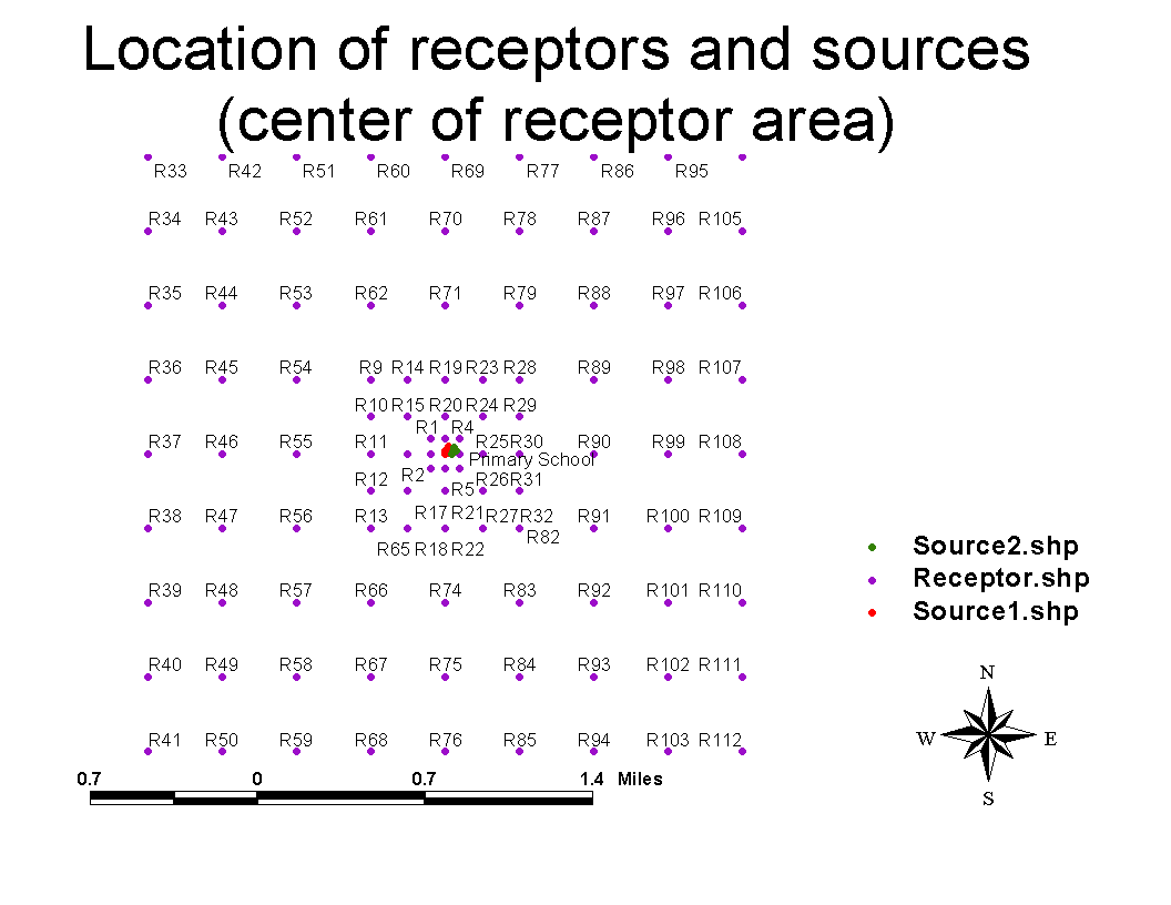
Figure 6
Risk Isopleths from A Single Source with Street Data
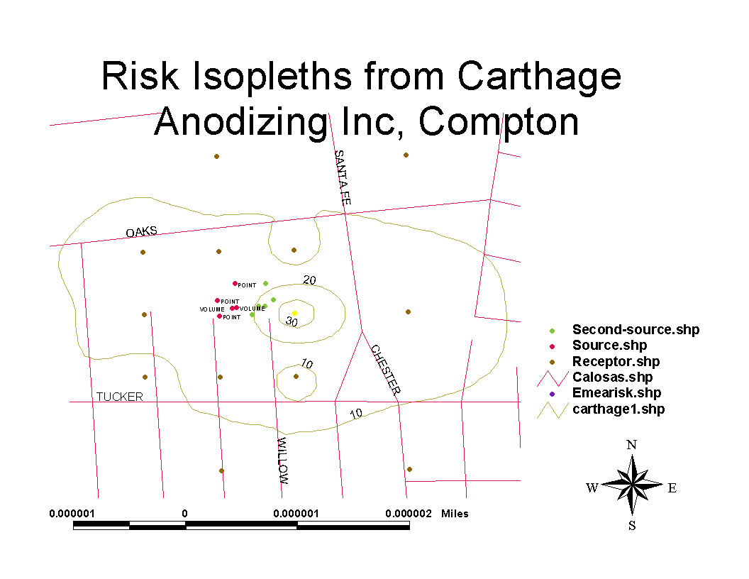
Figure 7
Risk Isopleths from Two Sources on the Same Receptors with Street Data
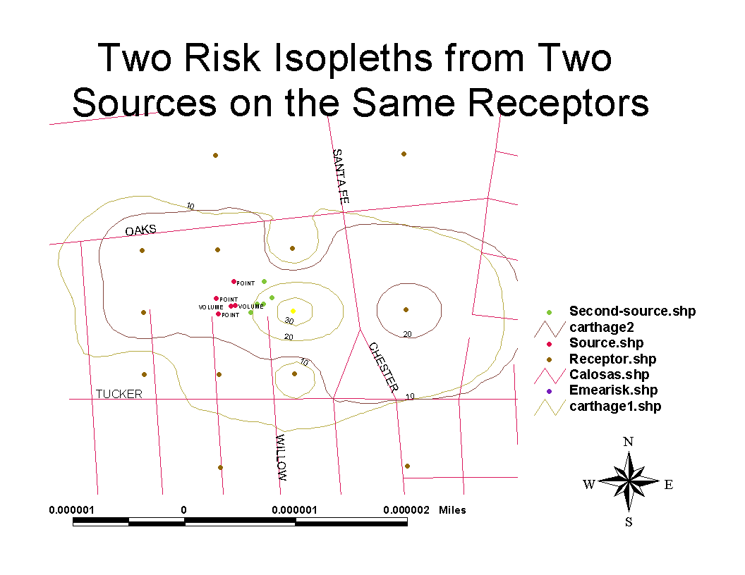
Figure 8
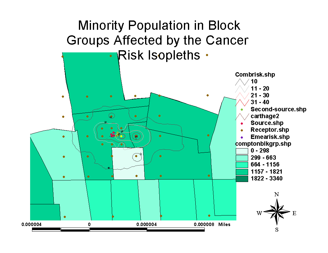
Determining Impacts of Risk Isopleths on Population Exposed
The questions asked most frequently in risk communication meetings are from individuals wanting to know what their own family is exposed to and if they are safe living in the risk isopleths displayed and what the regulatory agency or the industry is doing to address the problems. Questions such as these are to dealt with delicately and are also extremely difficult to answer. An inappropriate response could lead a complete breakdown of the communication and trust. The communication fails if the risk communicator resorts to technical jargon and downplays the risk of exposure or compares it to involuntary risk probabilities. The use of GIS is a tool among many others that can be utilized by the risk communicator to address public concerns and fears.
With GIS, the street layer and demographic information can be layered with the risk isopleths, to show the cumulative impacts, if any, on the community, and also the affected highest risk areas as shown in Figure 8. In comparison, quite often what is available to the risk manager is the static map as shown in Figure 1. With a GIS system, the risk manager can effectively answer the community questions and concerns about their concerns in an interactive manner. This paper hopefully demonstrates that GIS can be used to integrate dispersion models and can be a useful tool for risk communication.
Mohan Balagopalan
Senior Engineer
South Coast Air Quality Management District
21865 E.Copley Drive, Diamond Bar, CA 91765
909-396-27049(phone)
909-396-2999 (fax)