GIS assessment of the grassland yield variability over France :
soil types, management of interpolation reference points, and aggregation of outputs through a GIS
Isabelle DONET, Philippe CLASTRE & Françoise RUGET
The ISOP project (Prairies Information and Objective Survey) aims at a real time assessment of grassland yield variability for 200 geographical areas in France. It uses daily meteorological data interpolated at each area centroid, soils characteristics and percentages of soil area. Crop management information, obtained through a national survey, is also introduced. A crop model (STICS) is applied to assess grassland yield for each configuration (about 6000 simulations foreseen at all). At the end, the results are compared to statistics and aggregated at different spatial scales to be provided to the French Ministry of Agriculture.
1 - Introduction : context of ISOP project
Since 1997, the ISOP integrated system has been developed by three French participants [1]:
- the Ministry of Agriculture (through its Department of Statistics, the SCEES),
- the National Institute for Agronomic Research (INRA),
- the National Meteorological Service (METEO-FRANCE).
ISOP final purpose is to produce reliable estimations of the forage production, in order to give objective information to the Ministry of Agriculture to estimate real production farmer losses in case of local or global drought [2].
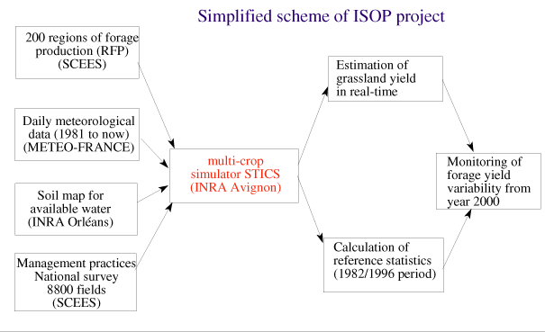
As shown in the simplified scheme of ISOP project, input data, include spatialized daily meteorological parameters, percent soil types, nitrogen status and amounts and frequency of mowing or grazing, estimated from a national survey. The STICS crop model [3] is applied to three kinds of grassland: permanent, temporary and pure legumes. The results are aggregated for 200 regions of forage production (RFP) and scored by comparison to statistical values simulated on a reference period (1982-1996). Results are summarized in alert maps and time-profiles of production rates in order to show drought-stricken areas.
This paper focuses on ARCINFO and ARCVIEW GIS use in the frame of ISOP project. From the beginning of the project, both INRA and METEO-FRANCE have been working on their GIS software : ARCINFO 7.2.1 at both INRA Orléans and Avignon and ARCINFO 7.1.1 and ARCVIEW 3.0 (with Spatial Analyst extension) at METEO-FRANCE. As it will be described later, the use of ARCINFO and ARCVIEW prevailed in the first steps of ISOP project for the determination, the characterization and the simplification of some important aspects of the system. Nevertheless, for the operational system, the use of GIS was rejected for several reasons and both UNIX and ORACLE DBMS software were preferred. ARCVIEW was retained only for the last steps to map ISOP aggregated operational outputs.
2 - Creation and characteristics of the 200 regions of forage production
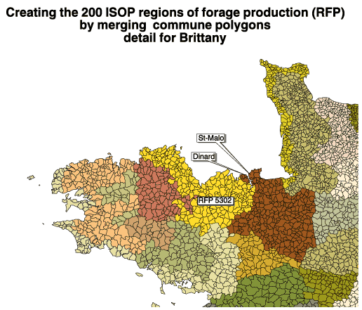
In 1997, the first step of the project involved the determination and the control of the 200 regions of forage production (RFP) over France. This was done through an ARCVIEW merging, applied on the 36640 French communes, which detailed polygons are available as an ARCINFO coverage, provided by IGN (National Institute for Geography). For each of these 36640 communes, in the attribute table, a corresponding RFP code was added by the SCEES and then the polygons were merged through ARCVIEW. An example of this geographical aggregation is presented in the map of the created RFP for Brittany, in the western part of France.
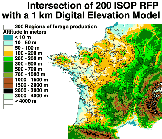
In a second step, it was necessary to control and characterize these 200 RFP. This was done trough several ARCVIEW operations :
- intersection of the 200 RFP with a 1 km Digital Elevation Model (DEM), looking for pixels with an elevation lower
than 1000 meters. The French 1 km DEM is available as an ARCINFO grid coverage, also provided by IGN.
- calculation of the RFP areas resulting from the previous step, checking values higher than 90000 hectares (SCEES requirements);
- finally, removal of RFP with a too low grassland area per type of grassland (data calculated and provided by SCEES),
to avoid problems of statistical representativeness . The RFP with calculated grassland areas lower than 7000 hectares
were so removed from the calculation.
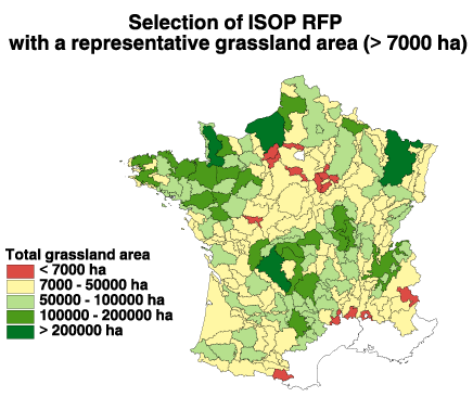
At the end of these first definition steps, among the 200 RFP, the relevant ones are :
- 182 RFP for permanent grassland type,
- 78 RFP for temporary type,
- 4 RFP for pure legume type.
All these RFP information were stored as an ARCVIEW shapefile with the corresponding attribute table.
3 - Daily meteorological data
The STICS crop model needs daily meteorological parameters (extreme temperatures, rainfall amount, global radiation and potential evapotranspiration -PET). These data must be available for all RFP and for both the reference period (1982 to 1996) and the current year to provide " real-time " outputs with a short delay.
A specific study was carried out in 1998 to check the availability of the data and to choose the best interpolation method (in terms of accuracy, robustness and quickness) between the ones available at METEO-FRANCE.
This study was completed in several steps :
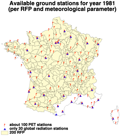
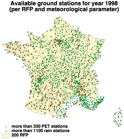
- a spatial overview of the available ground stations from 1981 to now was done on ARCVIEW and allowed to
calculate the density of available ground stations per RFP and meteorological parameter, from 1981 to now. The
available ground stations in 1981 for parameters like PET and global radiation are very scarce and many RFP have
no corresponding meteorological information. It was therefore impossible to select one station per RFP. On the
contrary, the 1998 ground stations network is denser and allows to represent the spatial heterogeneity of most
climatic fields, like the rainfall amount ;
- from the previous density calculation, it was decided to attribute only one meteorological data set per RFP, from 1981 to now ;
- to obtain the best daily interpolated data series per RFP, several interpolation methods were tested and compared : the Inverse Distance Weighted (IDW) method, the Kriging method and the neighborhood (connection to the closest station ) method. Accordingly, after spatial and temporal statistical comparisons, the most robust, fast and accurate method was the IDW ;
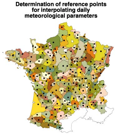
- each RFP received the climate value interpolated at its centroid. RFP centers of gravity were calculated with
ARCVIEW. The IDW method is applied for each meteorological parameter on the 5 closest available measured values.
- once the meteorological data sets were calculated for all RFP, a yearly control has been carried out in order
to validate the meteorological interpolated data sets with the original fields. These comparisons were completed
on ARCVIEW, by mapping RFP polygons values like the annual amount of ISOP interpolated PET in 1998 and
interpolating the original PET field of the 330 available ground stations in METEO-FRANCE database through Spatial
Analyst (" interpolate surface " function, applied on an event theme, use of IDW method on the 5 closest stations,
5 km resolution output mesh-grid)
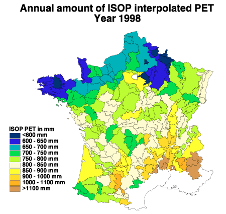
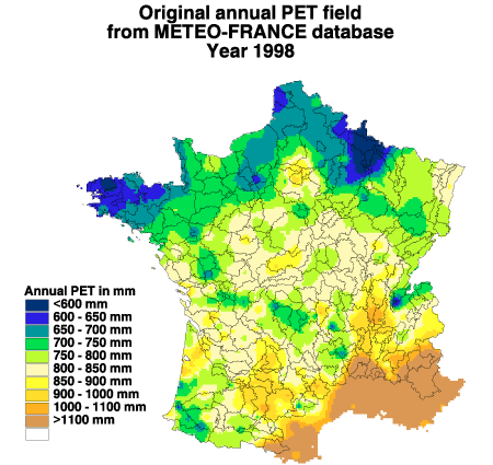
- Comparing these figures visually shows a reasonable similarity between the two fields of PET. Some differences can occur due
to the ways to calculate both fields :
- for the original field, only ground stations with all daily measurements are taken into account ;
- for the ISOP field, all available values are used day by day for the IDW interpolation per RFP.
The interpolation method in ISOP therefore produces satisfactory results.
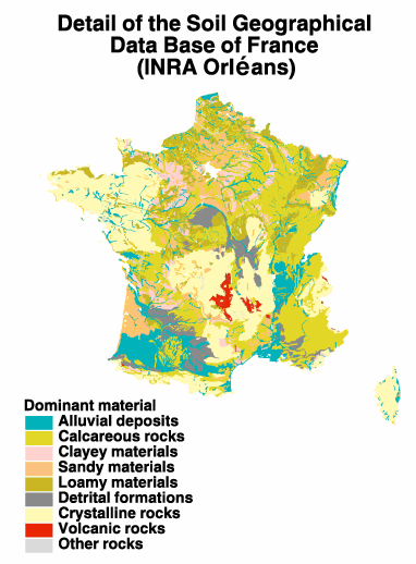
4 - Soil map
The Soil Geographical Data Base of France at 1 :1,000,000 scale [4] is used to provide soil map units. These soils are then characterized by their water characteristics per layer and nitrogen mineralization properties, and introduced into the system.
The Soil Geographical Data Base is available as an ARCINFO polygon coverage and its multiple attribute tables, at INRA Orléans.
One limit of this input information and its use through a GIS comes from the way each precisely referenced soil map unit (SMU) is distributed into several types of soils (STU), which are not geographically referenced but only in terms of percent of soil area. Moreover, grasslands are probably not randomly distributed on STU, but there is no available mean to attribute soils to grassland crops preferentially. Therefore, it was decided to simplify the number of soils polygons, by merging all parameters relevant to the STICS crop model (for example, no discrimination on albedo, fixed to the average value of French soils (0.2), which are always covered by the crop in grassland).
The resulting areas for each soil type were then calculated per RFP and the lowest values were removed from the final soil selection. At last, only 115 soil types remained available for ISOP, with the corresponding soil water capacities.
5- Management practices
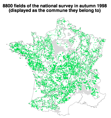
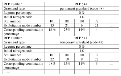
The management practices for mowing frequency and nitrogen supply were estimated from a national survey (8800 fields surveyed in autumn 1998) for the 182 (out of 200) RFPs with enough grassland surface. The results were concentrated and stored in the database of the Department of Statistics of the Ministry of Agriculture and then changed into direct inputs for the STICS crop model. These are values of thermal time between mowing, number of mowings, amounts of nitrogen supply during winter and spring, initial nitrogen indices .....
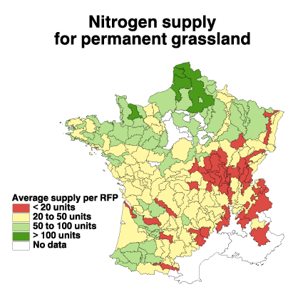
The survey data were geographically referenced to the French communes the fields belong to and then aggregated statistically per RFP and grassland type (percentage of occurrence for a given combination of parameters). For example, the average amount of nitrogen supply per RFP and grassland type is available for the ISOP project.
6- ISOP operating overview
From the previous steps, achieved on the different GIS and databases of both SCEES, INRA and METEO-FRANCE, the simplified outcomes were stored in a dedicated ORACLE database (2 Go space) at METEO-FRANCE. The operational calculations are done on this database and the results stored in the same way. The main characteristics of the operating system are described underneath.
The STICS multi-crop simulator was tested, completed and calibrated by INRA in order to properly simulate the behavior and the production of grassland over France [5]. Available experimental data were used to achieve these calibrations and adaptations of the crop model to the input data with spatial variation.
To assess the forage production at the country level and compare the values of the current year to statistics, the STICS crop model will be run for each combination of soil, mowing frequency and nitrogen amount for each grassland type in each RFP, then the results will be aggregated. In the operational mode, about 6400 simulations will be done to cover the 182 (of 200) RFPs of whole France. The calculation will be run automatically each ten-days period to allow the French Ministry of Agriculture to obtain " real-time " information at request.
This work will be completed at the end of year 1999. When simulations are complete, two complementary calculations will be carried out :
- the aggregation of assessed forage productions per RFP and grassland type;
- the calculation of the statistical reference values, based on the 1982 to 1996 period.
ISOP accuracy will also be tested and comparison between the ISOP assessments and the expert SCEES data will be realized for the whole system at the end of 1999.
7- Operational outputs of ISOP
From all these simulations and output data stored on an operational way, two main products will be provided at the request of the Ministry of Agriculture. Both will concern the relative values (ratioed to mean production) of the forage production, aggregated for each RFP and each grassland type. The assessed values will be provided through ARCVIEW, directly connected to the ORACLE database.
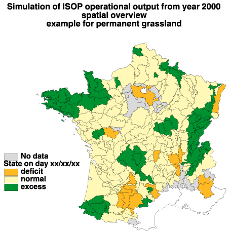
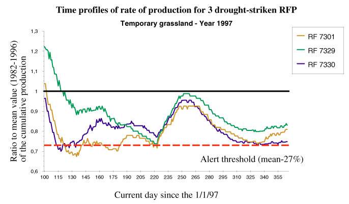
Two main operational outputs are foreseen for the operational monitoring :
- the first one corresponds to a national spatial overview of the potentially drought-stricken areas, displaying
the areas with the lowest production ratio. The database values will be displayed as RFP polygons;
- as second output, to complement the above spatial information, on relevant RFPs, time profiles of rate of
production or cumulative production will be drawn.
8- Conclusions and perspectives
ISOP integrated system was partly validated on a prototype, completed in 1998 and applied for 7 selected RFPs, by producing relative values consistent with expert data. In 1999, the global system will be applied to the 200 regions and on the reference period (i.e. since 1982). From the beginning of 2000, the Ministry of Agriculture will obtain objective relative values of the current forage production on request.
On GIS aspects, ISOP was the first project on which SCEES, INRA and METEO-FRANCE together started to use specific software and their possibilities. This first experimentation put in light several interesting points :
- the " crossing " possibilities of a GIS are really interesting for studying the context and the various input data of a study ;
- the interest of a GIS is largely dependent on the availability of precise input data. Its use is often restricted, due to a lack of data : the example of the Soil Geographical Data Base shows the strong need for georeferenced data at a national scale ;
- GIS software is also very useful for validation aspects, allowing to compare various data on a common support.
9- Acknowledgments
Since 1997, several experts have been taking an active part in the completion of ISOP project. The authors wish to thank most of them here :
- as end-users of ISOP, Ms Véronique RABAUD & Nicole BONNEVIALE from the department of Statistics of the French Ministry of Agriculture, actively participated in the completion of the system. They were also in charge of the national survey in 1998
- Ms Victorine PERARNAUD, head manager of the Agrometeorological Subdivision of METEO-FRANCE and Mr. Richard DELECOLLE, head manager of the Bio-climatology Unit of INRA Avignon took part in the management of the project
- Ms Christine LE BAS, from INRA Orléans was in charge of the simplification of the soil coverage in relationship to the STICS crop model requirements. She also provided of the final 6400 combinations of soil and cultural practices used in the operational ISOP system
- Mr. Michel DURU from INRA Toulouse, as expert in forage production, took part in all meetings to specify and validate the operational choices and simplifications
10- Bibliography
[1] Estimation of the year-to-year variability of grassland production in France- V.Pérarnaud, Isabelle Donet,
Françoise Ruget, Richard Delécolle
ECAM97 Lindau GERMANY 23-26/9/97 Annalen der Meteorologie 35 DWD p188-190
[2] Estimating alarm situations on grassland production at regional scale. Ruget F. & al., 1998.
7th ICCTA, Computer Technology in Agricultural management and risk prevention, Firenze, Italia, 15-18 November 1998,
abstract, 130.
[3] STICS: a generic model for the simulation of crops and their water and nitrogen balances.
Theory and parametrization applied to wheat and corn - N. Brisson, B. Mary, D. Ripoche & al.
Agronomy 18, p. 311-346
[4] La base de données géographique des sols de France - M. Jamagne, R. Hardy, D. King et M. Bornand, 1995
Etude et gestion des sols,Vol.2, N¡3, pages 153-172.
[5] Adaptation of an annual crop model (STICS) to a perennial crop : grassland - Ruget F., Duru M., Gastal F.
International symposium modelling cropping systems. Lleida, 21-23 June 1999, 111-112.
Author information
Isabelle DONET
study engineer at the Agrometeorology subdivision of METEO-FRANCE
in charge of ISOP operational software
METEO-FRANCE - SCEM/SERVICES/AGRO
42, avenue Gaspard Coriolis 31057 TOULOUSE Cedex FRANCE
email : isabelle.donet@meteo.fr
Philippe CLASTRE
study engineer at INRA Avignon
in charge of results mapping and unit hard and software choices
Unité de Bioclimatologie, Site AGROPARC
84 914AVIGNON Cedex 9 FRANCE
email : pcl@avignon.inra.fr
Françoise RUGET
research worker, ecophysiologist and crop modeller
in charge of the specific STICS version for forage production
Unité de Bioclimatologie, Site AGROPARC
84 914 AVIGNON Cedex 9 FRANCE
email : ruget@avignon.inra.fr