| James Villeponteaux | R. Max Creasy |
| Salmon River Restoration Council | USDA Forest Service Klamath National Forest |
A GROUND-BASED ACCURACY ASSESSMENT
OF CALVEG MAP ATTRIBUTES
DERIVED FROM LANDSATTM
IMAGERY
ABSTRACT
Natural resource decisions on
the public lands of the National Forests require base information of many
types and scales. Vegetation maps are one of the primary data sources in
use by analysts. Within Region 5 (California) of the U. S. Forest Service,
CALVEG maps provide consistent, region-wide coverage of major vegetation
attributes. An overview of map production methods is presented, as well
as procedures used to evaluate map attributes. Error matrices highlight
strengths and weaknesses of the maps and help direct future work to create
more effective maps.
BACKGROUND
The Salmon River is characterized by extreme topographic, geologic, climactic and disturbance conditions. These conditions are expressed in high vegetation composition and structural diversity. The Salmon River has long been known for its exceptionally high quality waters and high value fisheries as well as boasting one of the richest regions of species diversity in the temperate zones. It is noted to have the largest population of Spring Chinook salmon in California. In general, coniferous tree associations that change with elevations characterize the headwaters of the Salmon River. The major forest types have various understory elements that characterize them specifically, depending on soil type and exposure.
The Salmon River Basin is 98.7% federally owned, lying entirely within the Klamath National Forest. Federally designated wilderness areas occupy 45% of the Basin.
In comparison to other watersheds, the Salmon River subbasin is data rich, with available information on most physical and biological components in this watershed ecosystem. Highly reliable base resource maps are necessary for the public and resource managers to make effective decisions. Implementation of federal laws such as the Endangered Species Act and the National Forest Management Act have shown the need for multi-scale planning across patterns of multiple land-ownerships. Recovery efforts for salmonid species in the Pacific Northwest have highlighted these needs both at the basin scale and the watershed scale. National Forests and cooperators desire to have resource maps that are accurate enough for use at the watershed scale as well as the larger regional scale. Available funds or personnel often limit determining accuracy of maps.
One of the most important coverages for management and planning is Vegetation. This layer is used for timber typing, timber size classification, fuels condition and other aspects of management.
The current Vegetation layer was developed in 1976 from aerial photo interpretation. There are several sources of error in this coverage, which leads to an estimated accuracy of 60%.
The Salmon River Restoration Council (SRRC), and the USFS (Cooperators) have joined forces on several coordinated watershed education and improvement projects. The Cooperators signed a Memorandum of Understanding (MOU) in 1997, which establishes common goals in the Salmon River Watershed. As a part of the MOU, the Cooperators meet regularly and generate opportunities for SRRC involvement in resource management planning. Community participation and sharing of knowledge is a major component of the SRRC mission. This project is a direct outcome of a SRRC - USFS meeting. In the spirit of cooperative management, the Salmon River Restoration Council and Klamath National Forest have joined forces to assess the accuracy of the USFS-Region 5 CALVEG map at a watershed scale (60,000 acres).
CALVEG MAP AND PROCESS
In 1978, the USFS, California Region (R-5) embarked upon a program to provide a statewide existing vegetation classification and mapping program (Parker and Maytas, 1978). The classification system was intended to be inclusive of all major vegetation lifeforms or cover types (e.g. conifer forest, hardwood forest, shrub, herb) and not exclusive as the old timber type classification and maps. The name for this new program was CALVEG, and acronym for Classification and Assessment with LANDSATTM of Visible Ecological Groupings. As noted in the name, LANDSATTM imagery has been used since the inception of the CALVEG program. Initially, the vegetation type classifications were developed through correlation with existing classifications (Cheatham and Haller, 1975) and collaboration with local vegetation experts (e.g. Drs. John Sawyer and Dale Thornburgh, Humboldt State University).
In recent years, A Manual of California Vegetation (Sawyer and Keeler-Wolfe, 1995) has become the standard for vegetation type classification. The vegetation classification labels and rules of assignment are documented at the USFS - Remote Sensing Laboratory for each project area.
During early years, maps at 1:250,000 scale were derived from visual interpretation of the infra-red band with some level of field verification and contact with local experts. Color tone and textural pattern analysis was used to extrapolate information from training sites to adjacent areas (up to 30 mi.) The original map producers felt that an approximate 80% accuracy had been obtained by this method (Parker and Maytas, 1978). These maps were intended for regional (statewide) analysis and perhaps applicable to as small as Forest-scale planning (0.6 - 2.8 M acres).
Over the past two decades, the CALVEG program has undergone many transformations. The program now resides with the USFS R-5 Remote Sensing Laboratory in Sacramento. LANDSATTM imagery is still the base layer from which map attributes are derived. For processing, the California Region is now stratified into "Natural Regions" based on the National Hierarchy of Ecological Units of California (Miles and Goudy, 1997). This allows for more robust vegetation modeling rules by linking to geo-physical parameters with reduced variability. Methods employed on the Klamath National Forest by the RSL have been summarized (Allison, 1998; Remote Sensing Lab., 1992). Cover types are derived from imagery classification and manually edited on screen with 1:24,000 resource photography. Polygons, or "stand boundaries", are created through a image segmentation routine (Woodcock and Harward, 1992; Woodcock et. al. 1993). This process uses TM bands 3, 4 and the texture band derived from band 4 to generate polygons of 2.5 acres minimum. Polygons are intended to reflect changes in forest structure, composition and topographic orientation represented by the spectral and spatial characteristics of the input bands. Vegetation-type labels are assigned to the polygons by applying modeling rules to the created lifeform grids. Each natural region is modeled separately. Within each lifeform, elevation and slope-aspect grids are primarily used to model the vegetation types. In many natural regions, geologic parent material and soil grids were used to improve the models. The precipitation gradients within natural regions were reviewed for homogeneity relative to the ability to predict the occurrence of CALVEG types. Sharp gradients in precipitation were addressed by dividing the natural region. A canopy model is applied to the polygons to derive size and density classes (Li and Strahler, 1985). Thus, the resultant CALVEG map has five major attributes, thematic and spatial, that need accuracy assessment: polygon boundary, lifeform, vegetation type, size and density.
METHODS
The SRRC GIS analyst randomly selected Plots and digitally placed them in Conifer Lifeform polygons. The samples were dispersed to prevent auto-correlation. A SRRC crew collected information on the plots using standard FS Region 5 Forest Inventory Analysis 5 Point Cluster Plot protocol. We established 50 plus plots which meets the general guidelines for accuracy assessment (Congalton and Green, 1999) Reference data collected used the same thematic classification as the CALVEG data. This technique also collected stand Size, Density and Composition Information. The SRRC GIS analyst provided the field crew with maps and high resolution Digital Orthophoto Quads printed with sample plot locations. Using standard techniques the Crew reconnoitered to sample points within the study area. The crew used a Trimble Pathfinder Pro XL programmed with a data dictionary to collect plot information. As the Crew entered plot information, the Trimble GPS automatically collected GPS Locations. At the end of each day, the crew post-processed the data files to correct the GPSed location to a position accuracy of less than 1 meter. Because of automatic GPS collection, we could see how accurately the crew located each plot.
At the end of the field season, we
combined the multiple GPS Files using Trimble's Pathfinder Office software.
The combined and corrected data was then exported to ArcView 3.1 as a shape
file and delivered to FS for further analysis.
RESULTS AND DISCUSSION
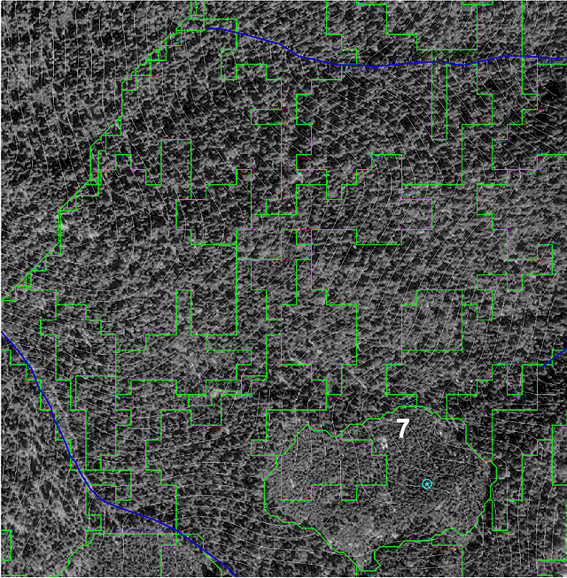
The spatial accuracy of polygon boundaries
was not reviewed in a quantifiable manner. The review over DOQs and photo-interpretedpolygon
maps revealed many boundaries that were not coincident or close. Generally,
the CALVEG polygons tended to fragment the stands to a greater extent than
traditional air photo-interpreted polygons created at similar mapping standards
(see Image in Conclusion Section).
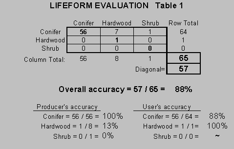
| The lifeform assessment for the conifer lifeform is close (86%) to the desired overall accuracy of 90% (see Table1). Other lifeforms were not selected for in the sample design and cannot be evaluated to the same degree. However, the 7 reference plots (9%) that showed hardwood lifeform instead of the mapped conifer lifeform, point toward a common misclassification by confusing canyon live oak with conifer. There are suitable reference plots available at the Forest scale (1:1,500,00) to evaluate other lifeforms. Current efforts will address overall accuracy of other lifeforms in the near future. | |
|
|
 |
|
|
|
|
|
 |
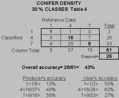 |
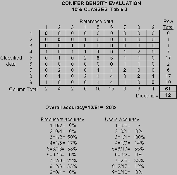
| Conifer size had an overall accuracy of 37% (see Table 5). Analysis of late seral stand amount and distribution is an important facet of NWFP implementation. These stands are defined by size class 4 and 5. The data suggests that these larger size classes are consistently underestimated. Greater than 50% of the size class 4 stands were modeled as 3 and the model failed to classify correctly any of the 3 size class 5 stands surveyed for reference data. | 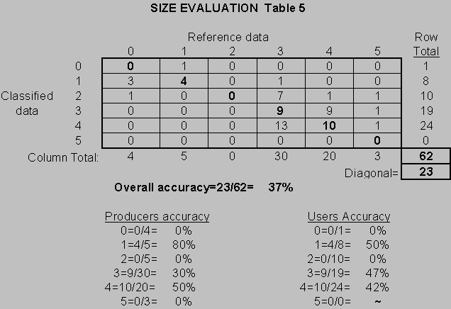 |
CONCLUSIONS
 |
The polygon boundaries are unacceptable in spatial representation and add confusion to the thematic attributes. Improvement of the image segmentation routine is of paramount importance since most users find the boundaries not related to what is on the ground. |
Lifeform, although displaying the greatest overall accuracy, still needs improvement in the conifer category and evaluation in the other lifeform classes. Because of the lesser amounts of other lifeforms and because of apparent spectral confusion between some hardwood and conifer types and hardwood and shrub types, overall accuracy is expected to be less for non-conifer lifeforms. Accurate classification of non-conifer lifeforms is extremely important for biodiversity analyses since landscape level species richness is highly correlated with the diversity of habitats available. Spectral training sets used during the supervised image classification need to be evaluated for representation of lifeforms by illuminated and shadowed areas.
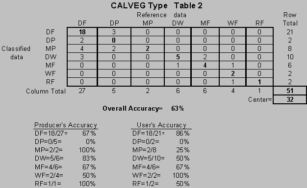
Vegetation type modeling shows promise, but needs to be redirected toward PNV type modeling. Existing vegetation attributes will be captured in lifeform, size and density attributes. Additional GRIDs in ARC-INFO (e.g. 10 meter DEMS, landform classification, topographic moisture, solar insolation and climate) will greatly improve modeling results and our understanding of interactions between vegetation and environment. Plots established on environmental gradients displayed in GRID can greatly improve the models by establishing correlations between vegetation types and environmental parameters of the model.
Size and density attributes derived
from the Li / Strahler canopy model need further refinement to reach desired
levels of accuracy for Forest and watershed-scale analyses. Improvements
in the spatial accuracy of the polygons, by reducing heterogeneity, may
improve the canopy model. Calibration of the model based on collected field
data can improve the data. The Forest Inventory and Assessment (FIA) data
collected on the 3.4 mile grid may help to calibrate the model. This data
was not available for calibration at the time of model development.
|
Salmon River Restoration Council PO Box 1089 Sawyers Bar, CA 96027 530-462-4665 email: jvptx@srrc.org |
USDA Forest Service, Klamath National Forest PO Box 410 Orleans, CA 95556 530-627-3291 email: Creasy_Max/r5_klamath@fs.fed.us |
Allison, Bonnie. 1999. A Summary of CALVEG Mapping Procedures. Klamath National Forest, Yreka, CA.
Biery, Edward H. 1998. Accuracy Assessment of Thematic Maps Derived from LANDSAT Imagery Using Fuzzy Set Logic. M. S. Thesis. Humboldt State University, Arcata, CA
Cheatam, Norden H. and J. Robert Haller. 1975. An Annotated List of California Habitat Types. University of California, Berkeley. Berkeley, CA.
Congalton, Russell G. and Kass Green. 1999. Assessing the Accuracy of Remotely Sensed Data: Principles and Practices. Lewis Publishers, CRC Press Inc., 2000 Corporate Blvd., Boca Raton, FL
Li, X. and A. H. Strahler. 1985. Geometric-Optical Modeling of a Conifer Forest Canopy. IEEE Transactions on Geoscience and Remote Sensing. 46: 12: 1563 - 1573.
Miles, Scott R. and Charles B. Goudy. 1997. Ecological Subregions of California. USDA - Forest Service, Mare Island, Vallejo, CA
Parker, Ike and Wendy J. Matyas. 1981. CALVEG, A Classification of California Vegetation. USDA - Forest Service, Region 5. Mare Island, Vallejo, CA
Remote Sensing Laboratory. 1992. A Process Paper on CALVEG Mapping. Remote Sensing Lab., USFS, Sacramento, CA.
Sawyer, John O. and Todd Keeler-Wolfe. 1995. A Manual of California Vegetation. California Native Plant Society, Sacramento, CA.
Woodcock, C. E., J. Collins, V. Jakabhazy, and S. Macomber. 1993. Forest Vegetation Mapping Methods Designed for Region 5 of the US Forest Service. Unpbl. Tech. Manual. Remote Sensing Lab., USFS, Sacramento, CA
Woodcock, C. E. and J. Harward. 1992.
Nested-Hierarchial
Scene Models and Image Segmentation. International Journal of Remote
Sensing, 13(16) : 316-318.