David Endelman
While cartography can be artistic, this paper explores why GIS cartography merits consideration as a way to create art. This paper reviews the concept of cartography as an art form. Examples are provided of the artistry of maps produced using traditional and GIS methods. Most importantly, arguments are given that GIS provides unique capabilities and methodologies for artistic expression. Finally, the benefits to the GIS community and the community at large are discussed.
Introduction
This paper is a reflection of my exploration of the use of geographic information systems (GIS) as an art form. This is a very new, but long awaited, journey for me. As a maker of maps, I am fascinated with the images and the information that I encounter and with which I interact. Cartographers have very broad access to geographic depictions and other forms of information from satellite imagery, aerial photography, GPS surveys, GIS coverages, CAD drawings, and hand-drawn maps. This gives cartographers a unique perspective to view and ponder the world in which they live. Tools such as GIS give remarkable power about how we "capture, store, update, manipulate, analyze, and display" spatial data (Esri 1990 p. 2). As part of my art, I want to share with others what I see and experience as a cartographer. In addition, I am curious about how others view the world in which they live. Therefore, I want my art to be accessible and interactive. GIS as an art form is relevant to me as an artist because it is a tool of our time that produces a sense of our time and place. The purpose of this paper is to discuss the basis of GIS as art, to provide examples of cartographic and GIS related art, and to discuss the value of GIS as an art form for our information age.
Basis for Cartography as Art
The precedent for GIS as an art form is in cartography as an art form. By definition, cartography is linked to art. Arthur Robinson writes "If one looks up 'Cartography' in a dictionary, the definition is likely to be brief and similar to 'the art and science of making maps'" (1989 p. 91). In fact the online dictionary by Merriam-Webster defines cartography as "the science or art of making maps." These similar definitions indicate that art and science are related aspects of cartography. These artistic and scientific aspects of cartography help form the distinctive nature of cartography as an art form.
Cartography as an art form reflects the interaction and relationship of art and science within cartography. There are links between cartography as an art and cartography as a science that show that methods are similar and perhaps goals. Also, there are also significant links between art and maps. This relationship between art and maps reflects the historic interplay of the "creative" products of artists and the "scientific" products of cartographers. Reviewing these relationships in some detail creates a better understanding about why cartography is a distinctive art form.
Links Between the Art of Cartography and the Science of Cartography
While the definition of cartography as an art and/or a science links these aspects of cartography, it also leaves room for debate if cartography is an art or a science. J.B. Krygier argues against the dualism of cartography as either an art or science. He instead presents the view that art and science are both valid modes of cartography (1995 p. 6). Krygier refers to the journal Leonardo that features articles by 'artistic scientists' and 'scientific artists' as an example where the distinction between art and science is minimized (p. 7). Debating whether cartography is an art or science is problematic because it diverts attention from the synergy brought from the interplay of the art of cartography and the science of cartography.
Commonalties between Artists and Scientists
Commonalties between artists and scientists help explain why cartography is a very scientific art and a very artistic science. Methods and perhaps goals are similar. "The 'makings and matchings' of the artists correspond to the 'conjectures and refutations' of the natural scientist" according to art historian E.H. Gombrich (quoted in Miller 1983 p. 222, Krygier p. 8). Krygier notes that in Leonardo articles "the focus is on goals and ideals and methods shared by artists and scientists: both art and science serve similar functions" (p. 7). Artists and scientists are similar in that they both explore and experiment, while they are dissimilar in that art is by nature subjective and science by design is objective. Because of their similarities and differences, art and science can compliment each other. Cartography is an example where art and science enhance each other.
Links Between Art and Maps
An artistic image is a common artifact of an artist's creative exploration. Likewise, a map is a typical artifact of a geographer's or cartographer's scientific exploration. David Woodward describes four major relationships or links that exist between art and maps. One, art can be present as an element in a map. Two, art can function as a map. Three, a map can be in a piece of art. Four, a map can be viewed (1987 p. 3-5). Throughout distant and modern history, there are many examples of these four relationships.
Categories and Examples of Cartographic Art
Art in Maps
According to Woodward, "Cartographic elements, such as color, symbols, and lettering, are shared with other visual arts." This forms the basis for the category of art in maps. In cartography and art similar tools and techniques are employed. These visual devices, tools, and methods form iconography. For cartography or art, iconography is an expression of the culture in which it is created (p. 3). The art in maps displays concisely what a culture finds important.
Art as Maps
"Artists have persistently turned their hand to mapmaking throughout history" states Woodward (p. 4). "Until science claimed cartography, mapmaking and landscape painting were kindred activities, often performed by the same hand" (Rees 1980 p. 60). Early contributors listed by Woodward are Leonardo da Vinci, Albrecht Dürer, Jacopo de' Barbari, Christoforo Sorte, and other Renaissance figures (p. 3).
The map of Imola created by Leonardo da Vinci and others is an example of art as a map. Woodward describes the significance this work stating that:
Leonardo's map of Imola ...not only is an extraordinary scientific document, being an early true orthogonal plan, but is an incredibly sensitive drawing that reveals the artist's full understanding not only of the structure of the city, but also of the riverbed beside it. It is art not in superficial ornamental sense, but because of the efficiency, clarity, and style with which it communicates the subject (p. 4).
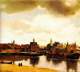
Vermeer's View of Delft, 1660-61
Image courtesy of Roy Williams
Vermeer's View of Delft is an example of a landscape painting where art serves as a map. Alpers refers to the genre of this painting as "topographic city views" (1987 p. 84). Williams states that Antoni van Leeuwenhoek, the inventor of the microscope, was a friend of Vermeer. Correspondingly, "it is assumed that Vermeer made this picture with the help of the camera obscura, an optical device like a pinhole camera to project a view on to a flat screen" (Williams p. hcc.html).
Alpers argues that artists have a "mapping instinct or impulse" (Woodward 1987 p. 4). Twentieth century artists considered by Woodward to have this a "mapping instinct or impulse" include: M.C. Escher, Jasper Johns, William Wiley, Christo, Claes Oldenburg, Thomas O'Donohue Ros, Misch Kohn, Beth Shadur, Newton & Helen Mayer Harrison, Hundertwasser, Stacy Farley, Martha Glowacki, Michele Turre, Richard Lutzke, Nancy Graves, Masako Miyata, Richard Long, Roger Welch, and many others (p. 5).
This link is to Jasper Johns' Map. This 1961 painting is an example of a modern artist with the "mapping impulse" referenced by Alpers and Woodward.
Maps in Art
There are vivid examples for the category of maps in art. Woodward cites Alpers about "the frequent appearance of maps in paintings, the most striking example being in the Dutch interiors of the seventeenth century." Woodward states that Alpers provides "strong evidence for a distinctive Dutch sensitivity to the map as an artifact and iconographic symbol" (p. 5).
Vermeer's
Art (or Allegory) of Painting,
1666-67
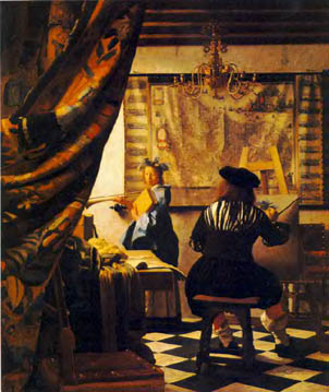
Image courtesy of Roy Williams
In the category of maps in art and a painting rich in beauty and symbolism is Jan Vermeer's Art of Painting. In this painting, Vermeer carefully depicts a map of the Netherlands where a large vertical crease divides liberated and occupied portions of the country (Williams p. ycg.html). Alpers shows how Vermeer's iconography represented by a map is an analogue for the art of painting (Woodward p. 5). In general, interpretations of the iconography represented in maps in Dutch paintings "include the idea of vanitas or worldliness, political or military power and authority, and science or learning" (p. 5). If the purpose of Vermeer were to portray one of these themes, it would not be a surprise that he would use a map to symbolize such a theme.
Maps as Art
There is a Dutch and European "custom of using maps as wall hangings even in simple homes" (Woodward p. 5). In addition, globes and cartographic artifacts have often been displayed simply because of their own intrinsic beauty. Woodward refers to Schultz who points out that many "maps represent a visual summa of contemporary knowledge, power, and prestige, some of it religious but most of it secular" (p. 5). The map in Vermeer's Art of Painting illustrates an example of a map displayed for its great beauty and strong statement.
Review of Historic Relationship between Art and Maps
Art and maps have historically interacted with each other and can provide similar practical and esthetic functions. The four relationships described here support the view that cartography is an art form. Maps, like art, form a visual summation of time, place, and a conceptual reference. There is a significant amount of literature documenting the art of cartography.
Examples of GPS, GIS, & Geoscience Related Art
So far, we have explored the artistry of maps that reflected the technology of their times; however this was a time before computers were commonly available. Computers and new technologies have changed how artists work. Stephen Wilson has categorized areas where artists are currently working with science and new technologies. This link is to Wilson's table about Conceptual Design and Info Arts. The link illustrates the extent of the interaction between art and science at the present time.
What has not been explored in this paper, or in fact in any real depth by artists in general, is the use of GIS cartography as a tool or material for art. With that said there are examples of GPS, GIS, and other geoscience tools being used to create art.
Di Castro's Art Works with Global Technologies
Using GPS the movement of the artist becomes the drawing in Di Castro's Art Works with Global Technologies project of 1996-7. Concepts in her work include movement as plot, nature as canvas, and global character. Di Castro was the lead artist in the Art Works with Global Technologies project. Collaborating artists for this project include Humberto R. Jardón, Andrea Wollensak, Sebastián, and Alberto Gutiérrez Chong. Collaborating technologists include Jose Férez Kuri, Edmundo Díaz, Armando López, Héctor Moreno, Carlos Salom, Ignacio Del Río, and Alejandro Nava. The collaborative nature of this project demonstrates how art involving high technology requires the cooperative work of many individuals with experience in many disciplines.
Stephen Wilson's Telepresent, 1997
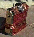
Image courtesy of Stephen Wilson
Stephen Wilson also uses GPS and mapping technology. About his 1997 Telepresent, Wilson states:
The present is a "magic" box with no wires that automatically sends images from wherever it is to others who are watching it via the web. People carry it with them for a short period in their life and then give it as a present to someone else...Wherever they go, web viewers can see whatever the telepresent sees. People on the web can also enter into the lives of the person who holds the present. They can send real time messages which will be spoken by the speech synthesizer inside the present. The telepresent uses GPS (Global Positioning Satellite) technology to automatically update its current position. The host server then uses automatic Internet maps to show web viewers exactly where the present is in almost real time (Wilson p. telepresent.html).
David Endelman's Line Drops, 1997
Courtesy of the Bakersfield Museum of Art
David Endelman's 1997 Line Drops demonstrates how unseen features displayable through GIS are employed for artistic expression. The lines in this image are of hundreds of underground and underwater pipelines that draw oil from a reservoir in the Huntington Beach area of California. This image was created by displaying and framing an Arc/Info coverage and then simply adjusting the line thickness. This work seeks to display a dramatic image not through technical manipulation, but rather by displaying only visual data that is essential to display a landscape of the unseen.
Line Drops was among 54 works created by various individuals that were included in the 1998 Computer Geoscience as Art exhibit at the Bakersfield Museum of Art in Bakersfield, California. This exhibit is believed to be the first comprehensive showing of computer geoscience as art in an art museum. Most works in this exhibit were produced using geological modeling software.
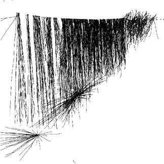
Beck's Sand Channel and Fault Model, 1997
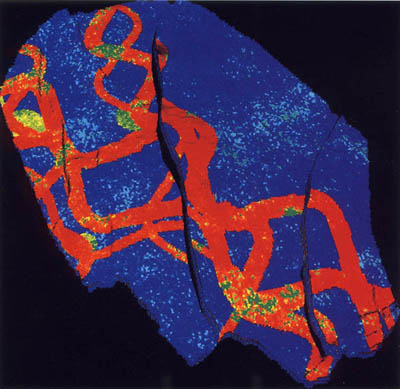
Courtesy of the Bakersfield Museum of Art
Produced with geological modeling software, Beck's Sand Channel and Fault Model is a geological study that is visually compelling. In this work red indicates ancient sand channels and blue shows a shale layer disrupted by faults shown in black. While this work was probably produced to portray a geological description, the beauty and the compelling nature of the work earned it a prominent position in the catalog for the 1998 Computer Geoscience as Art exhibit in Bakersfield.
The Value of GIS as an Art Form for the Information Age
The Art of GIS in Relationship to Art and Other New Technologies
This is a period of sharing of ideas and information between artists and technologists. While geoscience tools, especially GPS, have been used for artistic expression in collaborative projects between artists and scientists, GIS appears to be underrepresented. This is ironic because GIS offers enormous potential as a tool and a material for artistic expression. GIS has the capabilities to integrate, manipulate, manage, analyze, and display spatial data in a manner that is not industry or application specific. GIS imagery is powerful because it is potentially highly interactive and because spatial data is available on the web. Involving artists and technologists in creative projects such as developing the potential for GIS as an art offers meaningful benefits for artists, technologists and scientists, and for the community at large.
Artistic Benefits - add something about being interactive and web enabled
While every tool in a GIS toolkit offers potential for artistic expression, there are broad areas of benefit that can be categorized. GIS provides a dynamic portrayal of time and place. GIS provides access, management, and analysis of imagery. GIS is interactive. GIS is on the Web. GIS provides a multidisciplinary perspective. GIS reflects our technology and our culture. At a very broad level, GIS provides a spectrum of possibilities where every pixel can be portal to new understandings.
GIS Community Benefits
For scientists and technologists, the application of GIS as an art form expands the interdisciplinary nature of GIS. It popularizes GIS. It encourages a broader scope for GIS. It forces us to reexamine continually our assumptions. Ultimately, it encourages new synergies.
Benefits Now and Later for All People
GIS can provide a new perspective to view our planet and our universe for all people. GIS has the potential to allow new and old users to model the geography of whatever they can perceive or imagine. Using some form of GIS technology, interactive models of a view of reality or a view of imagination are presently more than just possibilities. For some these interactive models of geography will be science books, for others toys, games, or entertainment, and for still others it will be art.
Use of GIS for Art Concerns
While GIS may offer an intriguing means to explore our world from an artistic perspective it might be revealing to examine why GIS is not currently considered a tool of choice for many artists. Some reasons might include tools may be inadequate, tools may be cost prohibitive, tools may not be user-friendly. These possible limitations are also areas where GIS technology is making or is in progress of making significant improvements.
In lieu of a conclusion, I offer this question: If you are a visual artist, what would be the ideal tool set to express your relationship to the world around you at this millenium junction?
Map of Imola
http://www.colchsfc.ac.uk/euro-journal/imola2/leoing.htm
View of Deflt
http://www.ccsf.caltech.edu/~roy/vermeer/hcc.html
http://www.ccsf.caltech.edu/~roy/vermeer/hcc.jpg
Art or Allegory of Painting
http://www.ccsf.caltech.edu/~roy/vermeer/ycg.html
http://www.cacr.caltech.edu/~roy/vermeer/ycg.jpg
Jasper Johns' Map
http://www.posterdiscount.com/johns/joh2003.htm
Di Castro's Art Works with Global Technologies
http://www.imagia.com.mx/graficae.htm
http://www.imagia.com.mx/images/gps/plots/byn/gallery.htm
Stephen Wilson's Telepresent
http://userwww.sfsu.edu/~swilson/art/telepresent/telepresent.html
Stephen Wilson's Conceptual Design/Info Arts Links
http://userwww.sfsu.edu/~infoarts/links/wilson.artlinks2.html
Albers, S. 1987. "The Mapping Impulse in Dutch Art." In Art and Cartography: Six Historical Essays. Chicago: University of Chicago Press.
Anonymous. 1990. "Understanding GIS: The Arc/Info Method." Redlands: Environmental Systems Research Institute, Inc.
Eschner, S. 1998. "Computer Geoscience as Art." Bakersfield: Bakersfield Museum of Art
Keates, J. 1984. "The Cartographic Art." Cartographica 21: 1. pp. 37-43
Krygier, J. 1995. "Cartography as an art and a science?" The Cartographic Journal 32: 6. pp. 3-10
Merriam-Webster. 1999. "Merriam-Webster Dictionary." Available from Internet: AOL keyword MERRIAM-WEBSTER
Miller, J. 1983. "States of Mind." New York: Pantheon
Rees, R. 1980. "Historical Links Between Cartography and Art." The Geographical Review 70: 1. pp. 61-78
Robinson, A. 1989. "Cartography as an Art." In: D. Rhind and D. Taylor. Cartography Past, Present and Future: A Festschrift for F.J. Ormeling. London: Elsevier Applied Science Publishers
Williams, R. ? "Allegory of Painting." [Online]. Available: URL: http://www.ccsf.caltech.edu/~roy/vermeer/ycg.html
Williams, R. ? "View of Deflt." [Online]. Available: URL: http://www.ccsf.caltech.edu/~roy/vermeer/hcc.html
Woodward, D. 1987. "Introduction." In Art and Cartography: Six Historical Essays. Chicago: University of Chicago Press.
David Endelman
Principal, Geomatic Arts.
(805) 389-1689