Gunfire Location System Helps Stop
Crime in Urban Areas
The ShotSpotter system is
helping the Redwood City, CA police drastically reduce gunfire in their city.
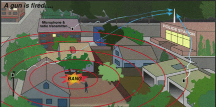
ShotSpotter uses a series of specialized microphones strategically placed around
the high crime areas of the city to listen for the sound of gunfire. When the
system detects a shot, it notifies a MapObjects based application that displays
the location of the shot, the names, addresses and phone numbers of surrounding
homes and businesses. It can even call the neighbors to see if anyone is hurt
or witnessed the crime. The map display can include aerial photographs to assist
police in planning their response.
Introduction:
|
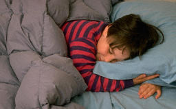
Gunshots
ring out in the middle of the night! You wake up and worry about your
children sleeping in the next room. What if a stray bullet has come through
the wall? You get up to check and everyone is safe and sound, this time.
It takes you a while to get back to sleep but finally you do. Imagine
this scene repeated 600 times a month in your neighborhood. To the people
of one neighborhood in Redwood City, California, this was a grim reality
before their police department installed the ShotSpotter system created
by Trilon Technologies. Since then, the number of gunshots reported in
the area has dropped dramatically.
|
|
System Description:
| The ShotSpotter
system relies on a series of 6 - 10 specially designed acoustic sensors
strategically placed in each square mile of the problem area. When a gunshot
goes off, the sound is picked up by the microphones and transmitted to the
ShotSpotter server in the police station. The system requires at least 4
microphones register the event before an analysis is made. It uses the time
difference between the gunshots reaching each microphone to triangulate
the location of the shooter. Sound travels at about 1000 feet per second
so a millisecond equals about 1 foot of distance. Within ten seconds, the
terminal in the police dispatch office sounds an alarm, and shows the location
of the shot on a map. |
 |
Prior to dispatching an
officer to the scene, a trained dispatcher listens to the recordings of the
event from one or more of the sensors and determines what the sound was and
if it warrants mobilization of police forces.
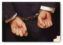
| The ability
to accurately identify the location of the gun also enhances the chances
of locating spent cartridges from the bullets fired. Each of these spent
cartridges will have a mark on them from the firing pin in the gun. These
marks are unique to each gun and provide almost fingerprint accuracy for
determining if a particular gun fired a bullet. |
 |
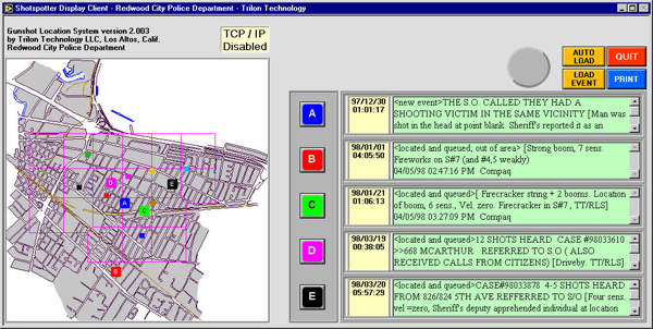
Original System Limitations:
The map used by the original
ShotSpotter system is a bitmap image of a CAD drawing. This posed several problems
for better utilizing the system.
� The dispatcher could not
zoom in or out to get more information on the area.
� Aerial photos could not be easily added to the system.
� The interface is too complicated for the average police dispatcher to use
without extensive training.
� No other information was available to the dispatcher such as owner's names
and phone numbers, gang affiliations and prior convictions
GIS Solutions:
In late 1998, Trilon Technologies
started working with Dialogic Communications Corporation (DCC) and Bradshaw
Consulting Services, Inc (BCS) to provide more information for the police and
to help solve more crimes.
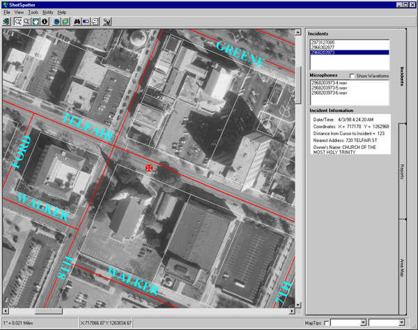
By using Esri's MapObjects,
BCS created a new user interface for the police dispatcher. This new interface
uses GIS data to provide real-time information to the dispatcher that makes
the police response safer and more effective. This new interface allowed the
dispatcher to see an aerial photograph of the area with all of the streets,
parcels and other features overlaid on the photo. It also provided information
about the location of the shot including the address, owner name and telephone
number for the nearest address.
|
The dispatcher could
now tell the responding officer, "The shots came from the bushes at the
right rear of the house at 412 Broad St.. The owner's name is Robert Jones.
No prior convictions and no gang affiliation reported." The officer has
a good deal of information before he even gets on the scene.
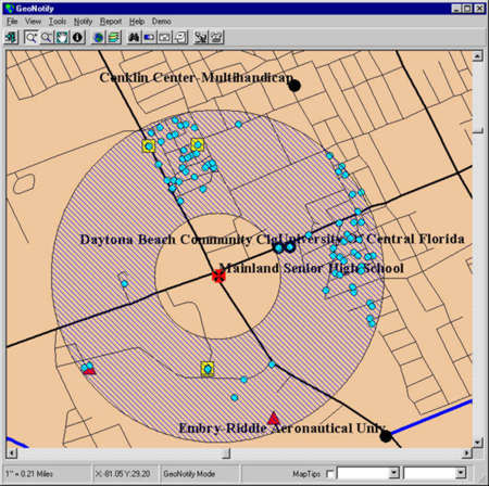
The dispatcher can
also draw a circle, rectangle or polygon on the area surrounding the shot
and immediately see a list of all homes and businesses within the area.
The list includes;
� Name
� Address
� Telephone Number
|
 |
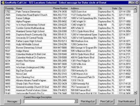
Notification:
Utilizing DCC's the Communicator,
the dispatcher can automatically initiate a call to all of the homes and businesses
in the area. A recorded voice would identify the call as coming from the police
department and ask a series of questions.
� Is anyone injured in your
home?
� Do you need assistance?
� Did you witness the shooting?
� Do you want to speak with a police operator?
| As the
homeowner responds to each question by pressing a button on the phone, the
response is automatically recorded and a printout is created at the dispatchers
office. This gives police a list of witnesses to interview without wasting
the time knocking on doors. The last question allows the homeowner to initiate
an immediate automatic connection to the local 911 service and report on
what is happening. "I just saw 4 young men get into a black station wagon
and speed off from the scene of the shooting." |
 |
Conclusion:
The combination of the ShotSpotter
acoustic monitoring, the GIS mapping and database system and the automated notification
capabilities provides the police with an effective weapon to reduce and even
eliminate gunfire in a monitored area.
Author Info:
Tony L. Bradshaw
President, Bradshaw Consulting Services, Inc
1359 Silver Bluff Rd. Suite G-5
Aiken, SC 29803
Phone 803.641.0960
Fax 803.641.6200
Tonyb@bcs-gis.com