Using GIS to Analyze the Profitability of Potential Wind Power Sites in the Competitive California Electricity Market
Sarah Bretz, Chris Marnay, Julie Osborn and Osman Sezgen
The goal of this work is to develop improved methods for assessing the viability of wind generation in competitive electricity markets. The viability of a limited number of possible wind sites is assessed using a geographic information system (GIS) to determine the cost of development, and Elfin, an electric utility production costing and capacity expansion model, to estimate the possible revenues and profits of wind farms at the sites.
The first component of the work is to develop data characterizing wind resources suitable for use in production costing and capacity expansion models, such as Elfin, that are capable of simulating competitive electricity markets. An improved representation of California wind resources is built, using information collected by the California Energy Commission (CEC) in previous site evaluations, and by using a GIS approach to estimating development costs at 36 specific sites. These sites, which have been identified as favorable for wind development, are placed on Digital Elevation Maps (DEMs) and development costs are calculated based on distances to roads and transmission lines. GIS is also used to develop the potential capacity at each site by making use of the physical characteristics of the terrain, such as ridge lengths. The results of this exercise are forecasts of profitable development levels at each site, using a simple levelized profitability calculation based on revenues forecast with Elfin. Using this method, about 26 TWh of electricity generation per annum can be profitably developed by 2010 at the 36 specific sites. By 2030, the potentially profitable amount of wind generation per annum reaches 34 TWh.
Introduction
The goal of this work is to develop improved methods for assessing the viability of wind generation in competitive electricity markets. In this phase, the profitability of a limited number of sites is estimated, and the likelihood of development determined. The approach improves on current capacity expansion approaches in a number of ways.
1. Rather than depending on a single generic resource to represent wind potential, a number of actual sites are evaluated individually.
2. The cost of development at each site is estimated using both generic technology cost information and site specific information.
3. Wind farm revenues are estimated based on patterns of generation derived from actual wind observations and estimates of time-varying market prices. In addition to attempting to improve on standard practice for capacity expansion modeling, this paper also demonstrates the benefits of such an approach when compared to simple levelized cost analyses.
The first step in the process is characterizing wind resources in a manner suitable for inclusion in production costing and capacity expansion models of electric power systems, such as the Elfin model, that are capable of simulating competitive markets. This characterization is typically in the form of a data set for model input that embodies the three key features that determine the viability of wind development: (1) estimates of the total resource; (2) estimates of the costs of developing the resource, and (3) an estimate of hourly potential generation. The information in (3) is of the utmost importance because it allows estimation of a potential revenue stream from sales into a competitive electricity market. Specifically, in this demonstration, an improved representation of the California wind resource is developed in the form of an Elfin data base, using information collected in previous site evaluations conducted by the California Energy Commission (CEC) and by using a geographic information system (GIS) approach to estimating development costs at specific sites. The Elfin model then uses these data to gauge the viability of wind farms at 36 specific sites. The results of this exercise are forecasts of profitable levels of development at each site, and forecasts of the effects of these developments on the electricity system as a whole, on fuel consumption, emissions, pool prices, etc.
Methods
Elfin
The Elfin model is a production costing and capacity expansion simulation program that has been widely used in California and elsewhere. Elfin uses a load duration curve dispatch simulation method, and picks an expansion program for the industry using the Iterative Test of Resource Effectiveness (ITRE) algorithm (EDF 1997). ITRE provides particularly attractive characteristics for work of this kind. ITRE is a simple search algorithm in which the most profitable new investments are made first and other investments chosen to the point that no further profitable new plant construction can be made. While this approach does not guarantee an optimal result and can lead to lengthy searches for the multiple possible equilibrium combinations of new investments, ITRE is capable of considering a large number of potential resource additions. In contrast to more common search methods, such as dynamic programming, choosing between many specific investment options does not lead to an insurmountable curse of dimensionality. Despite the vast number of combinations of investments possible at 36 wind sites over a 25-year period, ITRE successfully delivers results in reasonable computing times, typically a few days, on a Sun workstation. The ability to assess the viability of numerous alternatives is particularly important when multiple renewable generation options are to be evaluated because these tend to have much more variable characteristics than thermal technologies. In other words, while from an engineering standpoint, a modular combustion turbine can operate similarly anywhere within the state, wind sites will exhibit quite different output patterns. The Berkeley Lab has previously set up an Elfin model of the future California Pool. This database is a simple aggregation of the existing thermal generating resources owned by the incumbent investor-owned utilities together with in-state non-utility generators. The Berkeley Lab and EDF have also developed and implemented an algorithm for estimating the profitable level of entry by new capacity into the California market and for finding the combination of new investment that is the most profitable for investors (Marnay et al. 1997a).
To date, modeling of the California electricity market by the Berkeley Lab has focused on broad magnitudes of entry by new capacity, including renewable generators. Wind has consistently emerged as one of the renewable resources closest to commercial viability, but, prior to this work, no effort has been made to identify the exact extent and characteristics of wind resources within or near to the state; rather, wind has been represented within the Elfin model in the form of a simple generic generating resource with unlimited supply at a stated fixed development cost. Since wind generation appears to be the renewable resource most likely to penetrate the California fuel mix, a more rigorous modeling capability for the overall supply potential of this resource is necessary both to gauge the potential of wind, and to forecast operation of the California market with a significant wind contribution.
Geographic Information System
In this study, a more detailed inventory of the wind potential has been incorporated into the existing Elfin data base, providing a dramatic improvement over the current generic representation. This inventory has been developed in two stages. First, CEC studies conducted in the 1970s and early 1980s of favorable California wind sites were reviewed. These studies not only identify sites but also provide chronological wind data and other useful base information. Second, using GIS, these sites have been placed on topographic maps and their proximity to transmission lines and roads calculated. This information yields a more realistic estimate of development costs at the sites, and introduces a previously non-existent spatial element into the Elfin analysis. In simple production costing, possible generation options are represented as generic options that are chosen by the model based either traditionally on cost minimization, or, more recently, on profitability. The options contain no geographic information because any one unit of the generic resource is identical to any other. However, by developing multiple generic options based on actual surveyed sites, whose cost characteristics have been calculated using GIS, not only is the overall representation of the resource more accurate, but GIS also brings a spatial component into the analysis.
This inventory of wind sites has been entered into the Elfin model in the form of multiple generic resources, each representing the wind potential at one of the sites. Elfin capacity expansion runs then choose the viable sites and build wind farms accordingly. The key point to note is that the best wind sites in terms of wind class may not be the ones chosen first, for two reasons: first, the wind pattern may not be coincident with times of high electricity market prices; and second, the sites with good wind speeds may have other characteristics, such as poor transmission access that would make them costly relative to poorer but better-situated resources. In other words, Elfin is presented with a long-run supply curve of wind resources and it finds the level of development justified by the market price, but, because the information on the production and price sides is available, typically every three hours, this supply curve is complex and could not be readily drawn.
Sites
Previous Site Studies
The California Energy Commission (CEC) funded an extensive series of wind resource assessment studies in the late 1970s and early 1980s. These studies were conducted by various organizations ranging from research organizations, like SRI International, to meteorological consulting firms, to one-time wind generator manufacturers, like Boeing. As a result, the content and quality of the reports vary but the main emphasis in all of them is wind characterization at locations favorable to wind farm development.
The CEC studies do not cover the sites along the coastal mountains of Central California because, at the time, the Bureau of Reclamation of the U.S. Department of the Interior (DOI) was conducting its own wind energy study (DOI 1983).
A summary report by the CEC (Waco et al. 1983) evaluates all the consultant reports including the DOI study for the Central California coastal ranges and identifies Solano and Alameda Counties, the major east-west passes of Southern California (Tehachapi and San Gorgonio passes), and In-Ko-Pah Gorge in eastern San Diego County as the most promising sites with annual average wind speeds greater than 7 m/s (16 mph). Certain ridges below 1 800 m (6 000 ft) along the coastal mountains and the Portal Ridge-Sierra Pelona area in northern Los Angeles County, and several other locations with annual average wind speeds in the range of 6 to 7 m/s (13-16 mph) are also identified.
Based on the CEC studies, 36 sites suitable for development are identified (Table 1). As mentioned above, some of these sites have high average annual wind speeds (greater than 7 m/s). Marginal areas with average annual wind speeds in the range of 6 to 7 m/s are also included in our study set in case the diurnal and seasonal patterns of wind speed at these sites makes them more desirable than their average wind speeds indicate. More detail on the sites appears in Appendix A.
Table 1. Wind Sites and Numbers Used in This Report Identifying These Sites
|
Identifier |
Site |
Site Information marginal: wind speed at 10 m is less than 6.7 m/s |
||
|
1 |
Bear River Ridge |
(good) |
||
|
2 |
Solano Hills |
(good) |
||
|
3 |
Solano Hills |
(marginal) |
||
|
4 |
Altamont Pass |
(good) |
||
|
5 |
Altamont Pass |
(marginal) |
||
|
6 |
San Gorgonio |
Northern Foothills (good) |
||
|
7 |
San Gorgonio |
Whitewater (good) |
||
|
8 |
San Gorgonio |
Cabazon (marginal) |
||
|
9 |
Tehachapi Pass |
Cameron and Oak Ridges (good) |
||
|
10 |
Tehachapi Pass |
Pejuela Peak (good) |
||
|
11 |
Tehachapi Pass |
Downslope (marginal) |
||
|
12 |
Tehachapi Mountains |
La Liebre Ridge (marginal) |
||
|
13 |
Barstow |
(good) |
||
|
14 |
Barstow |
(marginal) |
||
|
15 |
Mountain Pass |
(good) |
||
|
16 |
Mountain Pass |
Clark Mountains (good) |
||
|
17 |
Gorman |
Sandberg (marginal) |
||
|
18 |
Sierra Pelona |
(marginal) |
||
|
19 |
Soledad Canyon |
(marginal) |
||
|
20 |
Portal Ridge |
(marginal) |
||
|
21 |
Fairmont Reservoir |
(good) |
||
|
22 |
Santa Catalina |
|||
|
23 |
Cajon Pass |
(marginal) |
||
|
24 |
Cajon Mountain |
(good) |
||
|
25 |
Strawberry Peak |
(marginal) |
||
|
26 |
Mt. Laguna |
(good) |
||
|
27 |
Julian |
Vulcan Mountain (good) |
||
|
28 |
In-Ko-Pah |
Boulder Park (good) |
||
|
29 |
In-Ko-Pah |
Sugarloaf Mountain (marginal) |
||
|
30 |
Table Mountain |
(good) |
||
|
31 |
Jacumba Mountains |
(good) |
||
|
32 |
Walker Ridge |
(good) |
||
|
33 |
Berryessa Peak |
(marginal) |
||
|
34 |
Potrero Hills |
(good) |
||
|
35 |
Pacheco Pass |
(marginal) |
||
|
36 |
Cottonwood Pass |
(marginal) |
||
Topographical Maps
At the outset, the intention was to develop a list of potential wind sites using data on wind power, roads, transmission data, population data, blackout areas such as federal land, and any other relevant GIS data sets available. Because a number of obstacles obtaining the necessary GIS data sets were encountered, the analysis was limited to the sites identified by the CEC, as described in Previous Studies.
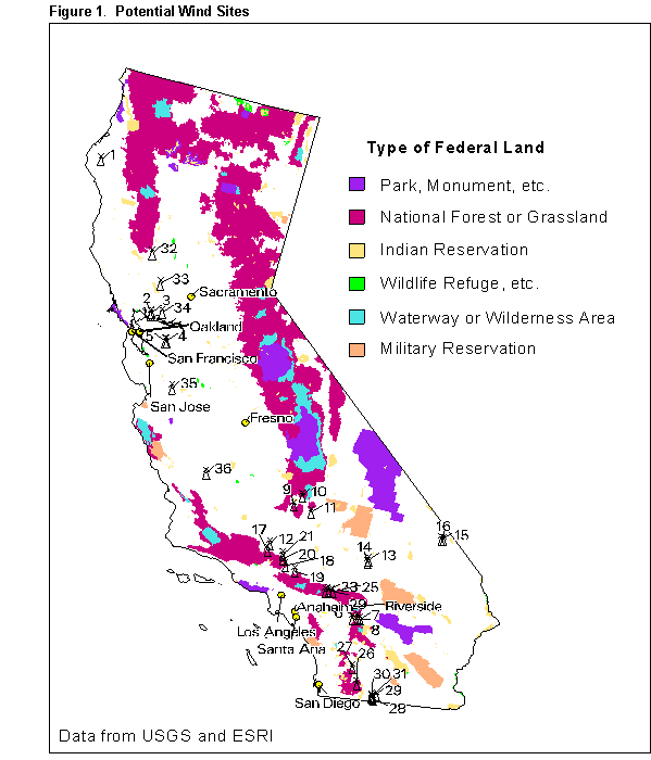
Figure 1 shows the 36 sites studied here. The actual site is at the hub of the windmill icon. The figure also shows areas of the state that were identified as possible blackout areas, that is, areas in which wind development may be precluded by special land use restrictions. Not marked are urban areas, which, similarly, are unlikely to prove hospitable to wind farms. This GIS information is not used in this analysis but is shown here to demonstrate how the GIS analysis could be expanded.
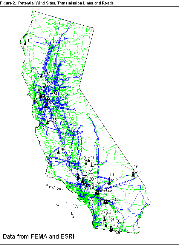
We obtained road data by converting an Environmental Systems Research Institute (Esri) Arcview U.S. road data set (Esri 1993) into an ArcInfo map, and selecting California roads. Difficulties were experienced obtaining an accurate transmission line map. One of the maps we obtained proved to be unusable because of problems with georeferencing of the original (computer-aided design) CAD file and attaching attribute data. Transmission lines obtained from the Federal Emergency Management Agency (FEMA 1988) were ultimately used. The lines were created by connecting known points in the distribution system of 115-500 kV lines. There is no attribute data associated with the lines. This transmission line map will be replaced by detailed data under development by the CEC. Figure 2 shows the potential wind sites against the roads and transmission lines. GIS was used to estimate proximity of CEC wind sites to roads and transmission lines. These distances serve as the basis for an estimated cost function of wind development.
Data on wind power were obtained from the National Renewable Energy Laboratory (Elliott et al 1986). A map of the wind power classes developed from their data is shown in Figure 3. Wind power classes are used to describe the energy contained in wind, averaged over area and time (Table 2). Areas designated Class 4 or greater are deemed suitable for advanced wind turbine technology under development today. The wind power classes were assigned based on the available windy land and wind electric potential per grid cell (Elliott and Schwartz 1997). Thus, they present a general idea of the wind power in a grid cell.
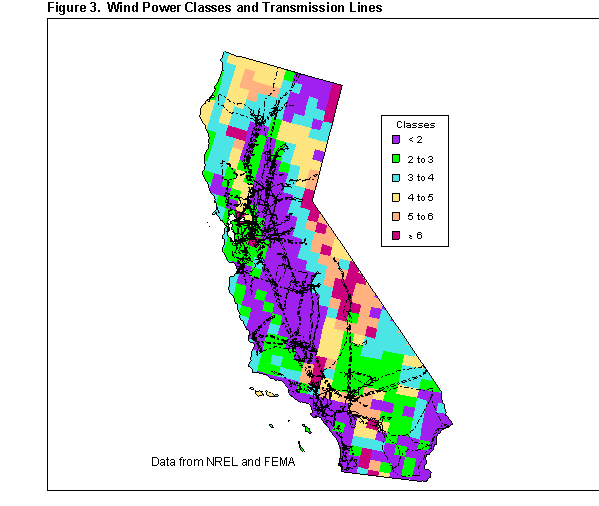
Table 2. Wind Power Classes at 50 m (164 ft)
|
Power Class |
Wind Power (W/m2) |
Speed (m/s) |
|
<2 |
<200 |
<5.6 |
|
2-3 |
200-300 |
5.6-6.4 |
|
3-4 |
300-400 |
6.4-7.0 |
|
4-5 |
400-500 |
7.0-7.5 |
|
5-6 |
500-600 |
7.5-8.0 |
|
>6 |
>600 |
>8.0 |
Source: Elliott and Schwartz (1997).
To assess the viability of development at specific CEC sites and to estimate the sizes of resources, when necessary, digital elevation models (DEM), which are digital records of terrain elevations for ground positions at regularly spaced horizontal intervals, were obtained. DEMs are developed from stereo models or digital contour line files derived from the U.S. Geological Survey (USGS) topographic quadrangle maps and provided by the USGS (USGS 1990). We processed the DEMs to create GIS surface lattices and contour line coverages. Using contour lines as a backdrop, we were able to place the CEC sites on our maps, following ridge lines and general topography.
Relief maps in the vicinity of the wind sites were then produced. Relief maps were constructed from DEMs. Major roads, rivers, lakes, and transmission lines are shown on the relief maps (Figures 4 and 5). Rivers and lakes were obtained from the Esri-ArcUSA data set. Again, wind sites are marked by the hub on the windmill symbol. We then used GIS to calculate distances from the wind sites to roads and transmission lines.
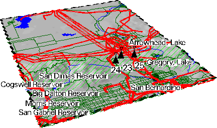
Figure 4. West San Bernardino
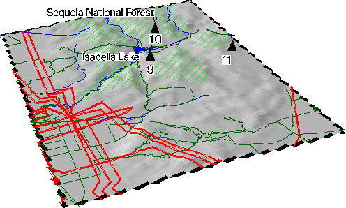
Figure 5. East Bakersfield
Choice of Technology and Cost Function
The typical size of wind generators commercially used has grown from 12.5-m rotor diameter in the early 1980s to 40-m diameter in the mid 1990s. A modern 40-m rotor diameter wind turbine typically corresponds to 0.5 MW of capacity. It is likely that during the next thirty years, due to improvements in design, 0.75- to 1-MW generators will be used more. However, the very large (1.5 to 3 MW) generators which were developed by funding from U.S., German, and British wind programs have not yet achieved commercial viability.
Experience of the last two decades shows that increasing size does not necessarily decrease generator costs per kW capacity, although the larger size does provide a scale economy related to operating and maintenance costs. The cost of servicing a wind generator is the same for all generators which are less than 50 m in diameter. For larger turbines, large cranes are needed for most repairs which increases maintenance costs and, possibly, some first costs such as construction of wider access roads.
In this study, we used a prototypical 0.5-MW (40-m rotor diameter, 50-m hub height) turbine in evaluating the sites. This follows from the argument that such a size is big enough to sweep a large area and yet small enough to keep the maintenance costs low. It also appears that the industry has been evolving in that general direction.
Contributors to the initial cost of a wind plant are the cost of the generators, the cost of the land where the generator is erected (this is generally quite small), costs associated with connecting the individual generators to the grid, and costs of building access roads. Operating costs include: maintenance costs, rents for the areas covered by the wind farm, and labor costs. In this study, using digital elevation maps to determine wind sites, resulted in an improved methodology for quantifying the distance to existing transmission lines and roads. Detailed estimation of the unit costs for the items listed above was not one of the main objectives of this study. However, information available in existing studies was incorporated in the cost calculations. Clearly, cost estimates could be improved by refining the unit cost based on recent surveys of equipment costs, land values, land rental rates, road construction costs, etc. Other factors such as proximity to other wind farms and population centers could also be included in the estimation.
Wind Power Plant Capital Outlay
Wind Turbine Generators
The trends in published transaction costs (cost plus profit) for wind power projects show that the price paid for wind power plants in California and Denmark fell dramatically in the 1980s (Gipe 1995). In California, the price in 1992 dollars came down from 4 000 $/kW in 1981 to 1 200 $/kW in 1987. NREL (1996) estimates the 1994 costs in the range 800 to 1 000 $/kW. The cost used by Union of Concerned Scientists based on prices they obtained from US Windpower is 1 032 $/kW for a 50-MW wind farm in the Midwest in 1992 dollars (Brower et al. 1993). In this study we used a cost of 1 000 $/kW. This cost is reduced by about one percent every year into the future. This figure includes the equipment, construction costs, land, and permits.
Connecting to the Grid
It is assumed that the wind farms would be connected to the grid through a substation. The line between the substation and the grid would be a high voltage line, typically 115 kV. Transmission lines from the substation to the grid will require 100 000 to 130 000 $/km depending on the terrain and a fixed hookup charge of $300 000. Within the site, turbines are assumed to be connected to the substation by low voltage lines of 4.16 kV at a cost of 50 000 $/kW. For each site, a $3 000 000 substation charge is assumed.
Access Roads
All weather access is required by maintenance crews. These roads also need to be built such that heavy equipment can be moved to the sites during construction. For this study 4-m (about 12 ft) wide roads are assumed necessary. The construction of roads are assumed to cost 22 000 $/km. For the land covered by the roads, a one-time cost of 375 000 $/km2 ($1 500 per acre) is assumed.
Operating Costs
Maintenance Costs
Maintenance costs compiled by Gipe (1995) indicate that they are about 0.012 $/kWh in 1992 currency. For some sites this may be substantially lower or higher. For this study we use 0.012 $/kWh.
Land Rent
Wind turbines occupy only a small fraction of the land area they are built over. Usually, the area can still be used for farming or grazing animals. In California, much of the sites are either on ridges or areas which are only suitable for grazing. The major exception is the Palm
Springs-Whitewater area which is mostly rural residential. In this study, we use a cost of 10 000 $/km2 ($40 per acre) per year in all areas except the Palm Springs-Whitewater area. For the Palm Springs area, we use 25 000 $/km2 ($100 per acre) per year. It is assumed that each 500-kW windmill will require an area of 0.04 km2 (10 acres), which is based on the generator-spacing assumptions covered in the next section.
Capacity and Profitability of Wind Resources
In this section, costs and estimated revenues for wind generators at each of the selected 36 sites are processed to provide a preliminary characterization of capital costs and profitability of wind resources in California. A simple levelized cost and revenue method is used. The summary section of the spreadsheet which serves as the database for the information on these sites is presented in Appendix A.
Characterization of the Wind
For each of the 36 sites selected, diurnal wind speeds (typically recorded every 3 hours) for four seasons (winter, spring, summer, and autumn), monthly average wind speeds, and annual average wind speeds are developed, based on the data collected in the CEC and DOI studies. Wind data are available for many of the sites at the above level of detail. The exceptions are the sites on the coastal mountains and in San Diego county. For these locations, diurnal average wind patterns are available either only for the whole year or only for winter and summer (as opposed to four seasons). On the other hand, for some of the other sites, there are hourly chronological data for more than one year. Data for the different sites are not necessarily coincident. They are typically for a year during the late 1970s or early 1980s. It is noted that sites with similar annual average wind speeds may have very different seasonal and diurnal patterns.
Estimation of Power
As mentioned above, for this study, a generic wind turbine of 40-m diameter and 50-m hub height is used. The wind speed at 10 m is used to estimate the wind speed at 50 m, and similar wind profiles for each of the locations are assumed, for lack of detailed information.
The power coefficient of a wind turbine is defined as the power delivered by the generator divided by the total power available in the cross-sectional area of the wind stream spanned by the blades. The maximum value for the power coefficient for the optimal blade design is 0.593. In practice, windmills can achieve power coefficients in the range of 0.4 to 0.45 (Eldridge 1975), and in this study we assumed a power coefficient of 0.45.
Given the above assumptions, the wind patterns for the sites in consideration are converted into potential power patterns.
Estimation of Revenues by Spreadsheet
The results of Elfin simulations are reported below, but a preliminary spreadsheet analysis of wind site profitability was conducted as follows. Elfin models the market and delivers results for both capacity expansion and dispatch. Electricity prices depend on what kinds of wind resources are built, and how they are dispatched. In other words, decisions about wind turbines and electricity prices are endogenous to the model. However, since the wind resources are small compared to other generating assets, we may assume that decisions about wind generation will not affect electricity prices significantly. With this assumption, electricity prices generated by Elfin in a previous run with the generic wind resource were used. Prices are generated with a diurnal pattern for each season. Superimposing these prices with the wind data, revenues at each of the 36 locations are calculated.
Estimation of Resource Capacity
Windmills are placed (positioned) in varying styles at wind farms. How closely the mills are placed relative to each other affects the performance of the site. The optimal site design depends on many factors such as the profile of the wind, the terrain, etc. Creating designs for each site is beyond the scope of this study so the following was assumed: (1) for the ridge sites, the windmills were placed three diameters apart, and (2) for the flatter areas, windmills were again placed three diameters apart across the wind and eight diameters apart along the prevalent wind. Based on these assumptions and the sizes of the 36 sites given in the CEC and DOI studies, the potential capacity for each site was estimated. If the size of the resource is not given in the CEC or DOI reports, they are estimated using GIS.
Capital-Cost and Profitability Curves
The wind capital cost curve presented in this report (Figure 6) shows the amount of annual generation at different levels of initial capital outlay in the years 2010. The resources in these curves are ordered from the highest annual generation to the lowest, for a given amount of initial capital outlay (Tables 3 and 4). The curve shows that the desirability of the resources in California at different sites vary considerably and exhibits a smooth diminishing-return to capital. It appears that, in the year 2010, for a $8.2 _ 109 capital investment, there is a potential generation of about 43 TWh/a. The same cost goes down to $6.5 _ 109 in the year 2030. In this study, it is assumed that the capital costs for wind development will decline at a rate of 1.15%/a during the study period.
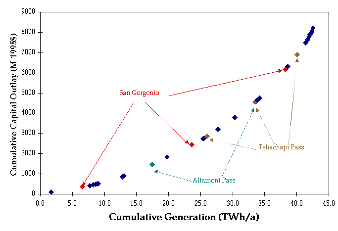
Figure 6. Site-specific Capital Cost Curve for the year 2010
Table 3. Capital Costs Wind Generation in 2010
|
Resource |
Cumulative Generation (TWh/a) |
Cumulative Capital Outlay (million $) |
|
26 |
1.7 |
92 |
|
6 |
6.6 |
361 |
|
27 |
7.7 |
424 |
|
30 |
8.3 |
459 |
|
31 |
8.6 |
485 |
|
29 |
8.8 |
503 |
|
28 |
9.1 |
522 |
|
2 |
12.8 |
866 |
|
24 |
13.1 |
897 |
|
4 |
17.4 |
1476 |
|
1 |
19.8 |
1826 |
|
7 |
23.7 |
2449 |
|
3 |
25.4 |
2735 |
|
16 |
25.6 |
2767 |
|
9 |
26.0 |
2853 |
|
34 |
27.7 |
3204 |
|
21 |
30.3 |
3786 |
|
5 |
33.5 |
4542 |
|
15 |
33.5 |
4551 |
|
10 |
33.6 |
4575 |
|
25 |
33.8 |
4635 |
|
12 |
34.1 |
4719 |
|
32 |
34.2 |
4751 |
|
8 |
38.2 |
6171 |
|
17 |
38.6 |
6318 |
|
11 |
40.1 |
6903 |
|
23 |
41.4 |
7486 |
|
35 |
41.7 |
7634 |
|
19 |
41.9 |
7782 |
|
20 |
42.1 |
7900 |
|
18 |
42.3 |
8006 |
|
33 |
42.4 |
8067 |
|
36 |
42.6 |
8216 |
Table 4. Capital Costs of California Wind Generation in 2030
|
Resource |
Cumulative Generation (TWh/a) |
Cumulative Capital Outlay (million $) |
|
26 |
1.7 |
73 |
|
6 |
6.6 |
286 |
|
27 |
7.7 |
336 |
|
30 |
8.3 |
365 |
|
31 |
8.6 |
385 |
|
29 |
8.8 |
399 |
|
28 |
9.1 |
414 |
|
2 |
12.8 |
688 |
|
24 |
13.1 |
713 |
|
4 |
17.4 |
1172 |
|
1 |
19.8 |
1450 |
|
7 |
23.7 |
1945 |
|
3 |
25.4 |
2172 |
|
16 |
25.6 |
2198 |
|
9 |
26.0 |
2265 |
|
34 |
27.7 |
2544 |
|
21 |
30.3 |
3007 |
|
5 |
33.5 |
3607 |
|
15 |
33.5 |
3614 |
|
10 |
33.6 |
3633 |
|
25 |
33.8 |
3681 |
|
12 |
34.1 |
3747 |
|
32 |
34.2 |
3773 |
|
8 |
38.2 |
4900 |
|
17 |
38.6 |
5018 |
|
11 |
40.1 |
5482 |
|
23 |
41.4 |
5944 |
|
35 |
41.7 |
6062 |
|
19 |
41.9 |
6180 |
|
20 |
42.1 |
6273 |
|
18 |
42.3 |
6358 |
|
33 |
42.4 |
6406 |
|
36 |
42.6 |
6524 |
We are assuming that, under the future regime, electricity prices will be tightly coupled to marginal costs. Under such circumstances, calculations given above can be taken one step further to include revenues and to calculate profitability of sites. Marginal electricity costs obtained from previous Elfin runs for California are used to evaluate the revenues for each of the sites yielding profitability estimates. Sites are ordered in terms of profitability and a profitability curve is presented in Figures 7 and 8 with information on the ordering of the sites in Tables 5 and 6, respectively. Figure 7 indicates that in the year 2010, up to about 26 TWh/a can be generated with positive profitability, that is, above simple break-even on costs. Figure 7 also shows the interesting suggestion that, output could be increased to about 34 TWh/a with only a marginal loss of 0.01 $/kWh, and to about 40 TWh/a with a marginal loss of 0.02 $/kWh. Figure 8 indicates that, in the year 2030, up to about 34 TWh/a can be generated with positive profitability, and output could be increased to about 41 TWh/a with only a marginal loss of 0.005 $/kWh. These results do not change much if average prices rather than time-varying pool prices are used for the above analysis. This is due to the fact that pool prices are relatively constant throughout the year except for summer afternoons.
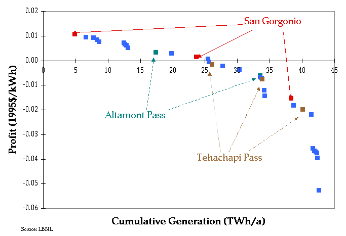
Figure 7. Profitability of Wind Resources in the year 2010
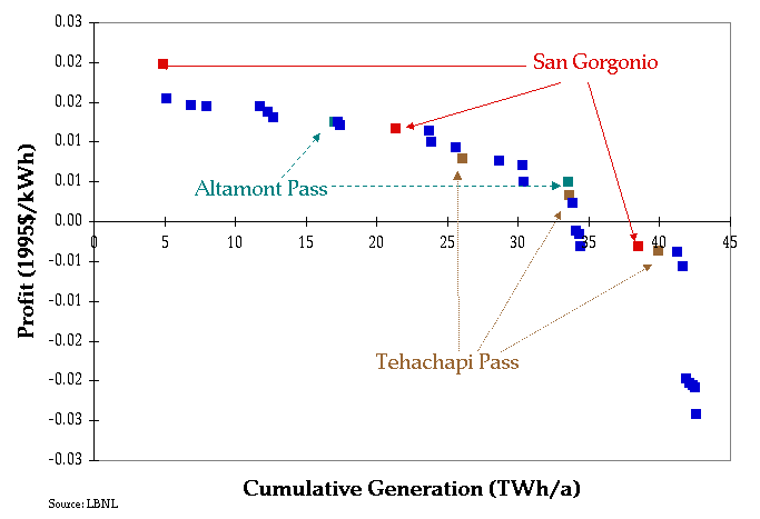
Figure 8. Profitability of Wind Resources in the year 2030
Table 5. Profitability of Wind Resources in 2010
|
Resource |
Cumulative Generation (TWh/a) |
Profit/kWh ($) |
|
6 |
4.881 |
0.011 |
|
26 |
6.595 |
0.009 |
|
27 |
7.737 |
0.009 |
|
30 |
8.283 |
0.008 |
|
31 |
8.626 |
0.008 |
|
2 |
12.407 |
0.007 |
|
29 |
12.621 |
0.007 |
|
28 |
12.836 |
0.006 |
|
24 |
13.075 |
0.005 |
|
4 |
17.410 |
0.003 |
|
1 |
19.770 |
0.003 |
|
7 |
23.654 |
0.002 |
|
3 |
25.410 |
0.001 |
|
16 |
25.586 |
0.000 |
|
9 |
26.038 |
-0.002 |
|
34 |
27.727 |
-0.002 |
|
21 |
30.322 |
-0.004 |
|
5 |
33.489 |
-0.006 |
|
15 |
33.523 |
-0.007 |
|
25 |
33.745 |
-0.007 |
|
10 |
33.842 |
-0.007 |
|
12 |
34.104 |
-0.012 |
|
32 |
34.198 |
-0.014 |
|
8 |
38.241 |
-0.015 |
|
17 |
38.625 |
-0.018 |
|
11 |
40.078 |
-0.020 |
|
23 |
41.391 |
-0.022 |
|
35 |
41.650 |
-0.036 |
|
19 |
41.898 |
-0.037 |
|
20 |
42.094 |
-0.037 |
|
18 |
42.270 |
-0.037 |
|
33 |
42.369 |
-0.040 |
|
36 |
42.563 |
-0.053 |
Table 6. Profitability of Wind Resources in 2030
|
Resource |
Cumulative Generation (Twh/a) |
Profit/kWh ($) |
|
6 |
4.881 |
0.020 |
|
24 |
5.120 |
0.015 |
|
26 |
6.834 |
0.015 |
|
27 |
7.976 |
0.015 |
|
2 |
11.758 |
0.014 |
|
30 |
12.303 |
0.014 |
|
31 |
12.646 |
0.013 |
|
4 |
16.982 |
0.013 |
|
29 |
17.196 |
0.013 |
|
28 |
17.410 |
0.012 |
|
7 |
21.294 |
0.012 |
|
1 |
23.654 |
0.011 |
|
16 |
23.830 |
0.010 |
|
3 |
25.586 |
0.009 |
|
9 |
26.038 |
0.008 |
|
21 |
28.633 |
0.008 |
|
34 |
30.322 |
0.007 |
|
15 |
30.357 |
0.005 |
|
5 |
33.523 |
0.005 |
|
10 |
33.620 |
0.003 |
|
25 |
33.842 |
0.002 |
|
36 |
34.036 |
-0.001 |
|
12 |
34.298 |
-0.002 |
|
32 |
34.392 |
-0.003 |
|
8 |
38.435 |
-0.003 |
|
11 |
39.888 |
-0.004 |
|
23 |
41.201 |
-0.004 |
|
17 |
41.585 |
-0.006 |
|
35 |
41.844 |
-0.020 |
|
19 |
42.092 |
-0.020 |
|
20 |
42.288 |
-0.020 |
|
18 |
42.464 |
-0.021 |
|
33 |
42.563 |
-0.024 |
Conclusion
In this demonstration analysis, a characterization of the wind potential of California has been developed using archival studies conducted by the CEC and by using GIS. The resource is represented as an Elfin input data set that is used to estimate profitabilty based on levelized costs and forecast revenues. Preliminary results indicate that about 26 TWh of wind-generated electricity can be profitably developed per annum by the year 2010 and 34 TWh per annum by the year 2030 in the 36 specific sites.
Acknowledgements
The authors would like to thank Jack Cadogan of the U.S. Department of Energy, Pat McAuliffe, Angela Tanghetti, and Joel B. Klein of the California Energy Commission, Brian Parsons, Michael Milligan, and Kevin Porter of the National Renewable Energy Lab, Dan Kirshner and Francis Chapman of the Environmental Defense Fund, and Joseph Eto and Jon Koomey of the Berkeley Lab for their help at various stages of this work. The work described in this study was funded by the Assistant Secretary of Energy Efficiency and Renewable Energy, Office of Utility Technologies, Office of Energy Management Division of the U.S. Department of Energy under Contract No. DE-AC03-76SF00098.
References
Berry, E.X, R.K. Hauser, and W.G. Lane 1981. "A Wind Energy Assessment of the Southern California Desert." Atmospheric Research & Technology, Inc. CEC Consultant Report Number P500-81-025.
Brower, C.B., M.W. Tennis, E.W. Denzler, and M.M. Kaplan 1993. "Powering the Midwest: Renewable Electricity for the Economy and the Environment." Union of Concerned Scientists, Cambridge, Massachusetts.
Davis, E. and R. Nierenberg 1980. "Wind Energy Prospecting in Alameda and Solano Counties." Volumes 1-2. Pacific Gas and Electric Company, San Francisco, California. CEC Consultant Report Number P500-80-054.
Environmental Defense Fund (EDF) 1997. "Elfin: Electric Utility Production Simulation and Integrated Planning System." Oakland, California.
Eldridge, R.E. 1975. "Wind Machines." Prepared for the Notional Science Foundation by The Mithre Corporation.
Elliott, D.L., C.G. Holladay, W.R. Barchet, H.P. Foote, W.F. Sandusky 1986. "Wind Energy Resource Atlas of the U.S." NREL National Wind Technology Center, Golden, CO. DOE/CH 10093-4. October.
Elliott, D.L, and M.N. Schwartz 1997. "Wind Energy Potential in the United States." National Renewable Energy Laboratory. Golden, CO.
Environmental Systems Research Institute (Esri) 1993. "Arc Info v. 7.0.4, Arcview U.S. Road Data Set."
Federal Energy Management Agency (FEMA) 1988. Transmission Line Database developed by FEMA with assistance from Argonne National Laboratory.
Gipe, P. 1995. "Wind Energy Comes of Age." John Wiley & Sons, Inc.
Marnay, C., Suzie Kito, and Osman Sezgen 1997a. "Entry into a Competitive Electricity Market: The Fate of Renewable Generators in the California Pool Beyond 2005." Proceedings of the United States Association for Energy Economics and the International Association of Energy Economics, International Energy Markets, Competition and Policy, San Francisco, California, 7-10 Sep.
Marnay, C., C. Richey, S. Mahler, and R. Markel 1997b. "Estimating the Environmental and Economic Effects of Residential PV Adoption Using GIS and NEMS." Proceedings of the 1997 Annual Conference of the American Solar Energy Society, Washington, D.C., 25-30 April.
Marnay, Chris, Dan Kirshner, Suzie Kito, Osman Sezgen, Steve Pickle, Katja Schumacher, and Ryan Wiser 1998. "Restructuring and Renewable Energy Developments in California: Using Elfin to Simulate the Future California Power Market." Berkeley, California. June.
NREL 1996. Wind Energy Information Guide. U.S. Department of Energy, Washington, DC.
Parsons, B. and Y.H. Wan 1995. "US wind reserves accessible to transmission lines." IEEE Power Engineering Review. Vol. 15(9).
Plaks, A., W. Wiesner, G.E. Miller, and R.L. Nielsen 1980. "Wind Turbine System for High Wind Regions of California." Boeing Engineering and Construction Company, Seattle, Washington. CEC Consultant Report Number P500-80-005.
Richmond, M.C. and R. Anderson 1984. "Wind Prospecting in San Diego County California: Summary Report." Meteorological Research, Inc., Canyon Country, California. CEC Consultant Report Number P500-84-005.
Ruff, R.E., M.K. Bland, R.M. Endlich, R.L. Kiang, and L. Jones 1983. "Wind Energy Assessment for Northwestern California." Volume 1. SRI International, Menlo Park, California. CEC Consultant Report Number P500-83-021.
Simon, R.L. 1980. "Location of Sites for Wind Power Development in Northeastern California." Global Weather Consultants, Inc., San Jose California. CEC Consultant Report Number P500-80-053.
U.S. Department of the Interior (DOI) 1983. "Central California-Nevada Wind Energy Study." U.S. Department of the Interior, Bureau of Reclamation, Mid-Pacific Region. Sacramento, California.
U.S. Geographical Survey (USGS) 1990. "One-Degree Digital Elevation Models." Originated from the Defense Mapping Agency. Reston, VA.
Waco, D., M. Wurst, M.D. Batham, S. Michael, and R.W. Kukulka 1983. "Wind Resource Assessment of California." California Energy Commission, Sacramento, California. CEC Staff Report P500-83-019.
Zambrano, T.G., S.N. Walker, and R.W. Baker 1980. "Wind Energy Assessment of the Palm Springs-Whitewater Region." Volume 1. Aero Vironment Inc., Pasadena, California. CEC Consultant Report Number P500-80-016. Co-funded by Southern California Edison.
Zambrano, T.G. and G.J. Arcemont. 1981. "Wind Energy Assessment Studies for Southern California." Volumes 1-4. Aero Vironment Inc., Pasadena, California. CEC Consultant Report Number P500-81-031.
Author Information
Julie Osborn
Principal Research Associate
Lawrence Berkeley National Laboratory
1 Cyclotron Road, MS 90-4000
Berkeley, CA 94720
510-495-2420
510-486-7976
JGOsborn@lbl.gov