1999 Esri User Conference
July 24-30, 1999
San Diego, California
William Saunders
Texas Natural Resource Conservation Commission
Austin, Texas
Abstract
Digital Elevation Models are being employed with increased frequency in the pursuit of watershed-based approaches for water resources studies and assessments. Accuracy in the digital replication of receiving stream networks and watershed boundaries is of utmost importance, particularly in cases where mathematical models may be linked to the DEM-derived output. Depending on the map scale of the DEM utilized, certain hydrologic features of a watershed may become obscured or oversimplified during the digital delineation process. The integration of a vector hydrography layer into the DEM prior to watershed delineation is one method that can correct for this loss of detail. This method is commonly referred to as "stream burning" and several such techniques are presented and discussed.
1. Introduction
2. Previous Work
3. Methodologies
4. Application to Galveston Bay Watersheds
5. Conclusions
6. Acknowledgments
7. References
8. Author Information
Introduction
The use of Digital Elevation Models (DEMs) for the purposes of automated watershed and stream delineation has increased dramatically in recent years. With the advent of software algorithms for quick and efficient processing, automated approaches are quickly replacing traditional manual methods of watershed delineation. Advantages of using these automated approaches include process reliability and reproducibility, savings of time and labor, and results which, within the context of a digital domain, can easily be linked to other meaningful data sets compiled for the region under study.
As the lead environmental agency in Texas, the Texas Natural Resource Conservation Commission (TNRCC) is tasked with oversight and implementation of various water resources programs, including the Total Maximum Daily Load (TMDL) program, the Water Availability Modeling (WAM) project, and the Source Water Assessment and Protection (SWAP) program (TNRCC, 1998). These programs have significant modeling components that rely on accurate geospatial representations of the systems under assessment. For example, each program requires the accurate identification of drainage areas for literally thousands of point locations that represent water quality segment endpoints, surface water quality monitoring stations, wastewater discharges, USGS flow gages, water right diversions, and surface drinking water intakes/outlets. Given the volume of work required for these projects, automated methodologies for the expedient and accurate determination of drainage areas are desirable.
The Arc/Info Grid module and ArcView Spatial Analyst extension are two software utilities that provide for automated watershed delineation from DEM data, through application of the fill, flowdirection, flowaccumulation, and watershed algorithms. Investigations (Saunders and Maidment, 1995; Mizgalewicz and Maidment, 1996) have shown, however, that the use of raster data sets for watershed and stream delineation can produce stream networks that are inconsistent with generally accepted vector representations, such as those depicted on USGS 7.5-minute quadrangle maps, the EPA's River Reach files, or the Digital Line Graphs (DLGs) of the USGS. These inconsistencies are due to problems of map scale and the lack of adequate DEM vertical resolution in areas of low relief.
One method that can help to resolve the problem of digital stream network replication involves the integration of a vector hydrography data layer into the DEM prior to watershed delineation. This process is commonly referred to as "stream burning" and can be effective in the digital reproduction of a known and generally accepted stream network. The process is not without its drawbacks, though, as the vector hydrography layer chosen for integration must be at a similar scale as the DEM and must undergo extensive pre-processing prior to the "burn-in". Other deficiencies with the process have also been noted, such as the erroneous introduction of artificial parallel streams into the drainage network (Hellweger, 1997) and the distortion of watershed boundaries delineated from the burned DEM (Saunders and Maidment, 1996).
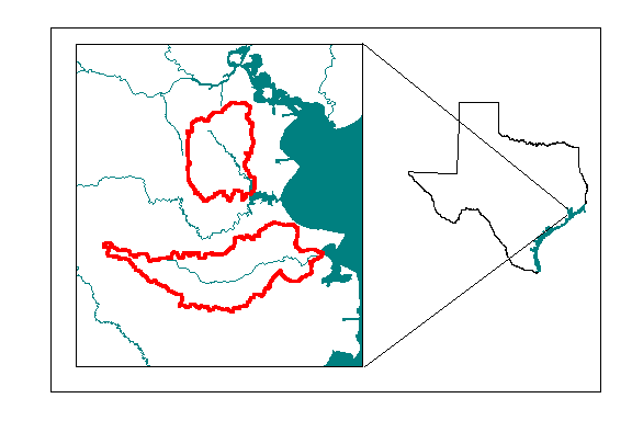
This paper investigates various DEM manipulation techniques that involve the integration of a vector hydrography layer. The examined techniques largely represent the experiences of the author. Advantages and disadvantages of each of the techniques are discussed. The Armand Bayou and Dickinson Bayou watersheds, which are small coastal watersheds in the vicinity of Galveston Bay (Figure 1), are used for this analysis. These watersheds represent the natural drainage areas to water quality stream segments that are on the State of Texas 1999 Clean Water Act Section 303(d) list (TNRCC, 1999).
Previous Work
Establishment of a Model
The concept of using DEM data to derive a representation of surface hydrography was fostered with the development of the Deterministic-8 Node (D8) algorithm (O'Callaghan and Mark, 1984). The D8 algorithm stipulates that, for a matrix (grid) representation of topography, flow moves from each node (cell) to one and only one of its eight nearest orthogonal or diagonal neighbors, and is in the direction of steepest descent. Marks, et al. (1984) used this concept in creating an iterative algorithm to determine a grid of flow accumulation from a DEM. However, the number of iterations performed in this procedure was proportional to the number of grid cells in the longest flow path, and the algorithm was computationally prohibitive for large DEMs.

Figure 1 - The Armand Bayou (north) and Dickinson Bayou Watersheds in southeast Texas
Jenson and Domingue (1988) introduced the concept of drainage enforcement with an automated basin delineation program that acknowledged the existence of spurious sinks in the DEM. This program allowed for the elimination of the sinks by either (a) raising the elevation of the sink point to that of its lowest neighbor or (b) lowering the elevation of the lowest saddle point surrounding the sink. By pre-processing the DEM in this manner, a fully dendritic flow accumulation network was established for all grid cells in the DEM. This concept has been implemented into the Arc/Info Grid module and ArcView Spatial Analyst extension as part of the fill algorithm.
The drainage enforcement concept, as discussed by Jenson and Domingue, has since been widely applied, with mixed results, for a variety of watershed and stream network delineations. Saunders and Maidment (1995) used a 3-arc second (1:250,000-scale) DEM for a delineation of the San Antonio-Nueces coastal basin in south Texas. That analysis showed that, in the topographically diverse portion of the basin away from the coast, there was close agreement of the delineated stream network and drainage areas with the generally accepted USGS 1:100,000-scale DLG stream network and USGS Hydrologic Cataloging Units. However, in the near-coast portions of the basin, where slopes were generally flat, drainage paths were distorted and tended to "short-circuit" the actual known locations of streams and tributaries, following the DEM paths of gravitational least resistance instead (Figure 2).
Integration of Vector Hydrography (Stream Burning)
The notion of drainage enforcement in DEMs has evolved in the years since Jenson and Domingue (1988). Taking the idea one step further, Hutchinson (1989) discussed the incorporation of stream line data into the DEM to force flow through the grid cells corresponding to the stream line network. The process modified the elevation values of grid node points along the stream lines, constraining the elevations of interim stream line points to maintain local uniform descent. The process also ensured that the resultant delineated stream lines were located at the bottom of their accompanying valleys.
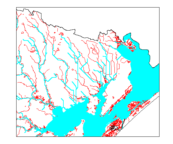
Figure 2 - Digitally delineated steams (blue) in the eastern San Antonio-Nueces Coastal Basin, superimposed onto the USGS 1:100,000-scale Digital Line Graph (Saunders and Maidment, 1995)
To correct for the previously encountered problems in the San Antonio-Nueces coastal basin, Saunders and Maidment (1996) integrated an edited version of the USGS 1:100,000-scale DLG stream network into the 1:250,000-scale DEM prior to watershed delineation. This process converted the edited stream network to a grid comprised of single-cell strings, assigned the corresponding DEM cells with a value of zero, and then added a fixed value (five meters) to all off-stream cells of the DEM. Figure 3 shows the resultant improvement in digital stream delineation accuracy for the San Antonio-Nueces coastal basin.
As part of a study on the GIS modeling of agrichemical transport, Mizgalewicz and Maidment (1996) reported on a process of DEM adjustment. The adjustment entailed integration of the 1:500,000-scale River Reach File 1 (RF1) hydrography layer into a small scale (500-meter grid cell size) DEM of the upper Mississippi-Missouri and Ohio River basins. This integration process raised all off-stream DEM cells by an arbitrary value, but retained the original DEM elevation values for the in-stream cells. The Arc/Info Grid fill algorithm, performed on the adjusted DEM, also provided the benefit of smoothing the resultant in-stream elevation depressions. The stream burning process was important to this study so that flow length estimations (and chemical travel times) would not be underestimated.
Olivera (1996) and Strager, et al. (1998) also provide examples of the stream burning technique employed by Mizgalewicz and Maidment. DiLuzio (1999) is currently employing the process for all river and coastal basins in Texas through an integration of the EPA's River Reach File 3 (RF3) layer into a 1-arc second DEM.
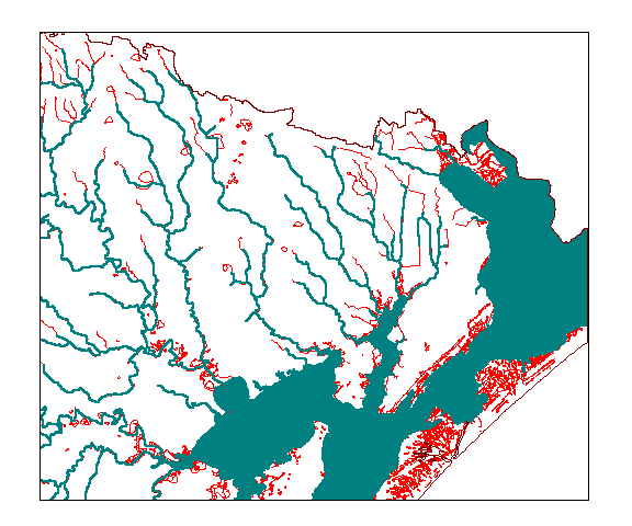
Figure 3 - Digital streams created from a hydrography integration process (blue) compared with the USGS 1:100,000-scale Digital Line Graph (red) (Saunders and Maidment, 1996)
Recent Developments
Some limitations of the above stream burning methods have been noted. Saunders and Maidment (1996) observed distortions in watershed boundaries for drainage areas delineated with hydrography-enhanced flow direction grids (Figure 4). Reed (1999) reported similar results and observed that the extent of the stream burn-in process (i.e. the difference between the elevations of stream cells and land surface cells) has a significant influence on the way that flow directions are assigned in flat areas. Hellweger (1997) noted that stream burning processes tends to introduce parallel streams into the digital landscape in areas where the hydrography differs from the original DEM-delineated flow path by more than one grid cell. In efforts to address some of these anomalies, various DEM adjustment methodologies have been recently investigated.
Hutchinson (1996) described an adaptive interpolation process for smoothing discretization errors between adjacent DEM grid cells through an iterative resampling of the DEM. This approach has been integrated into the Australia National University DEM (ANUDEM) software package (Hutchinson, 1998), which also uses contour line data and stream line data to interpolate a smooth raster landscape surface from a data set of irregularly spaced elevation data points.
Garbrecht and Martz (1997) created the TOpographic PArameteriZation (TOPAZ) software package to perform automated analyses of digital landscape topography. While it does not explicitly provide for integration of vector hydrography into the DEM, TOPAZ employs a method of pre-processing the DEM for watershed delineation by either filling pits and depressions or lowering the elevations of cells that obstruct flow paths. TOPAZ also eliminates flat areas from the DEM by imposing a relief based on the surrounding terrain topography.
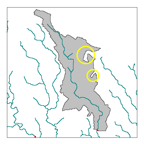
Figure 4 - Watershed boundary distortions (circled) resultant from a stream burning algorithm applied to the San Antonio-Nueces Coastal Basin (Saunders and Maidment, 1996)
In an effort to address the issue of erroneous parallel streams introduced through stream burning, Hellweger (1997) created an alternative DEM surface reconditioning system called AGREE. AGREE notes the DEM stream cell locations that correspond to a chosen vector hydrography layer and smoothes the elevations within a user-specified buffer distance of the vector layer. The extent of the elevation smoothing within the buffer is also determined by a user-specified forcing factor. After buffer smoothing is performed, the buffer zone is lowered by a fixed amount into the landscape. AGREE also provides for watershed boundary elevation reconditioning of a DEM through integration of a vector ridgeline layer. The AGREE surface reconditioning system was applied by Quenzer and Maidment (1998) for determination of digital stream networks and drainage areas in the Corpus Christi Bay system.
More recently, Reed (1999) reported that, for hydrography integration processes, a smaller elevation differential between stream cells and land surface cells results in a more sensible assignment of flow direction values in flat areas. In accordance with that observation, a procedure has been developed that introduces a small elevation gradient in flat areas toward grid cells with a known flow direction. This process replaces the integer elevation values in the flat areas with floating point values that gradually decrease toward defined in-stream grid cells of the flow direction network.
Methodologies
Stream Burning Conventions
The process of integrating vector hydrography into a raster elevation layer (stream burning) can be summarized in four general steps: (1) rasterization of a digitized (vector) stream network, (2) assignment of DEM elevation values to the grid cells of the raster stream network, (3) manipulation of the stream network raster cells to ensure that elevations progress in a descending manner toward the outlet point(s), and (4) introduction of a fixed elevation differential between the stream network raster cells and the land surface raster cells. Stream burning promotes the digital replication of known stream networks through the automated flowdirection and flowaccumulation functions. This is important to ensure stream network coincidence with point locational data, such as stream gages, discharge locations, and sampling stations, that may have been located using Global Positioning System (GPS) techniques. The achievement of an accurate stream network is also important for water quality modeling purposes; for example, to ensure that pollutant kinetic decay parameters are applied for the appropriate stream length and period of time.
Vector hydrography integration processes can easily be misapplied. Not all vector and raster data layers have sufficiently compatible map scales for the integration process and the process of preparing a hydrography layer for integration is tedious and fraught with pitfalls. However, a stream burning methodology can produce accurate watershed results if a few basic, but significant, rules are adhered to:
Map Scale - A vector data layer should never be burned into a raster data layer of coarser resolution. Figure 5 illustrates the problems of burning streams into a DEM when the two layers are not of similar scale. In Figure 5a, a representation of a fine scale (e.g. 1:100,000 DLG) hydrography layer is superimposed over two conceptual grids, one coarse and one fine (e.g. a 3-arc second (~90 meter) DEM and a 1-arc second (~30 meter) DEM). The rasterization of the hydrography layer, for each case, is shown in Figure 5b. Note that any grid cell through which a piece of the hydrography layer passes is converted to a raster stream cell. Figure 5c shows the results of a stream thinning process, which is performed to reduce the flow network to strings of single cells. By superimposing the original hydrography over the stream cells in Figure 5c, it can be seen that integration of the fine scale vector layer into the coarse scale DEM results in an oversimplification of the stream network. Note that one original tributary is completely omitted from the coarse network and that any point locational data that may be geo-referenced to that tributary would not fall on a cell of the coarse network.
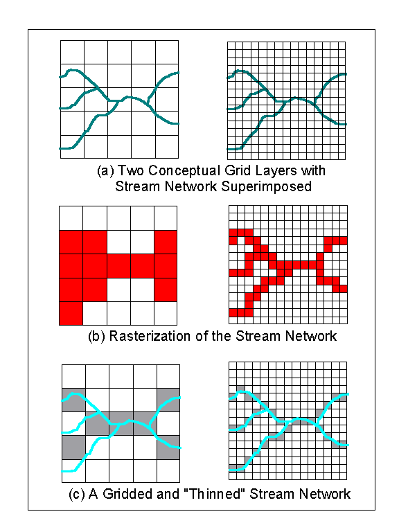
Figure 5 - Burning streams into DEMs of different scales (TNRCC, 1998)
Vector Hydrography Pre-Processing - Prior to integration into a raster data layer, a vector stream network (e.g. EPA RF3 or USGS DLG) must be edited to create a layer that is fully dendritic, i.e. a layer that represents the drainage network with a fully connected set of single lines. In order to achieve this fully dendritic layer, the following steps must be taken:
(1) All off-stream lakes (enclosed polygons) must be removed. The arcs of a hydrography layer that represent lakes actually represent the shorelines of the lakes. If these features were to be burned into the raster landscape, the result would be a number of circular trenches that would serve as local sinks. Execution of the fill command would resolve this problem, but at the expense of additional processing time for the additional sinks.
(2) In-stream lakes must be replaced with arcs that would otherwise bisect the lake. For large lakes with multiple arms/branches, a replacement dendritic transport path must be identified or created. These transport paths have been created for the National Hydrography Dataset (NHD) as "centerlines" (Dewald and Roth, 1998).
(3) All coastlines must be removed. The only arcs remaining in the hydrography layer should represent drainage paths to the eventual outlet(s) of the watershed.
(4) All streams in the hydrography layer that are large enough to be represented by a left and right bank must be replaced by a single arc in the center of the stream. This is consistent with the concept of ensuring that all drainage paths are represented by a single line.
(5) No bifurcations (braided streams) are allowed. For those streams where braiding naturally occurs and is depicted in the hydrography layer, a primary drainage path must be chosen and all other paths must be separated from the network. This does not mean that "secondary" drainage paths should be deleted from the layer. Alternatively (and preferably), secondary paths can be disconnected at the node where bifurcation occurs. (Note: When bifurcations are burned into a DEM, a primary drainage path is defined by the flowdirection algorithm, which uses the D8 model. These D8-determined drainage paths can vary from the known primary paths. Allowing for the DEM elevations to determine primary flow paths defeats the purpose of stream burning.)
(6) The main stem(s) of the drainage path(s) must extend to the edge of the corresponding DEM. In some cases (e.g. coastal watersheds draining to a bay), this may entail extending drainage paths from the mouths of rivers out into the open water. For non-coastal watershed delineations, this will probably be a non-issue.
(7) No stray arcs (i.e. linear features that are not connected to the stream networks) should remain in the final layer. "Disappearing" streams that are represented in the original hydrography layer should either be eliminated or connected to the dendritic network.
(8) The closest hydrographic features of adjacent watersheds (i.e. upper tributary reaches) that overlay the DEM should also be burned into the landscape. This will ultimately provide stream burning "balance" near the delineated watershed boundary lines and will help to mitigate watershed boundary distortion. Pre-processing steps 1 through 7 also apply to the hydrographic features of the adjacent watersheds.
Figure 6 shows the results of applying the above pre-processing steps to the Armand Bayou hydrography layer. For comparative purposes, the edited layer is superimposed over the original USGS 1:100,000-scale DLG.
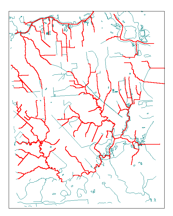
Figure 6 - An edited USGS 1:100,000-scale DLG layer (red), prepared for integration into a raster DEM, and superimposed over the original DLG layer (blue).
Hydrography Integration Methods Employed
Four different hydrography integration algorithms were applied for stream network and drainage area delineation of the Armand and Dickinson Bayou watersheds. A baseline delineation without hydrography integration was also performed. Each algorithm was programmed in the Arc Macro Language (AML) and executed with the Arc/Info 7.2.1 GRID module on a Sun Sparc20 UNIX workstation.
Three of the four hydrography integration algorithms can be referred to as "stream burning" algorithms. The fourth, Agree.aml, is more accurately described as a surface reconditioning algorithm. The three stream burning programs have a common structure: (1) convert the pre-processed hydrography layer to a grid representation of the stream network, (2) perform a thinning process on the grid to reduce the flow paths to a single cell width, (3) implement a method of burning the stream grid cells into the landscape, (4) execute a fill command to ensure that no elevation depressions occur, and (5) execute the flowdirection and flowaccumulation commands. What follows is a brief description of the hydrography integration technique employed in each of the AML programs:
Fillburn.aml - This stream burning algorithm assigns all stream grid cells with the elevation values from the original DEM while assigning all off-stream cells with the DEM values plus an offset value of 1000 meters. After the fill command is executed, the stream-burned grid is algebraically subtracted from the filled grid and the largest value in the resulting difference grid is recorded. Once that value is retrieved, the 1000 meter offset is subtracted from the off-stream values, while the stream grid cells are reduced by the maximum value from the difference grid, incremented by one. This process ensures that the stream burning offset value is only one unit deeper than the amount of the maximum fill height.
Expocurv.aml - The Expocurv.aml algorithm replaces the stream grid cell elevation values in each individual stream reach with values fitted to an exponential curve between the highest occurring elevation in the reach and the lowest occurring elevation in the reach. Additional processing is also performed to account for short reaches with no elevation change and to ensure that the highest and lowest occurring elevation values in the reach occur at the most upstream and most downstream cells of the reach, respectively.
The Expocurv.aml procedure still requires a stream burning offset value, however. That offset is determined by first comparing the exponentially fitted elevation values with the lowest elevation values in a 3x3-cell neighborhood of the stream grid cells in the original DEM. The offset value is then calculated as the maximum difference from that comparison, incremented by one. Finally, all stream grid cell that have elevations less than -1 are set to �1.
Agree.aml (Hellweger, 1997) - The Agree.aml algorithm offers a less computationally complicated and more processing efficient alternative to the other stream burning methods applied. In addition to integrating a vector hydrography layer into the landscape, Agree also smoothes the elevations inside a user-specified buffer zone by providing a linear fit to the grid cells from the edge of the buffer zone to the cell locations of the raster streams. Agree accepts two user-specified elevation offset values, a "smooth" value (for integration of the vector stream network into the DEM) and a "sharp" value (for integration of the smoothed buffer zone into the DEM). Utilization of the sharp offset value has the effect of burning a wider "trench" into the digital landscape. For application to the Armand and Dickinson Bayou watersheds, the hydrography layer is buffered by 150 meters, a smooth offset value of -5 feet is selected, and a sharp offset value of -2 feet is specified.
Tribburn.aml - The final stream burning algorithm represents an effort to digitally replicate the vector hydrography network while concurrently mitigating watershed boundary distortion errors. Observations of previous watershed boundary distortions show that they result from variations in the flow direction network occurring in close proximity to the grid cells burned into the digital landscape. Furthermore, the extent of the observed flow direction variations (and extent of the resultant watershed boundary distortions) are proportional to the elevation differential introduced through the stream burning process (Reed, 1999).
With Tribburn.aml, the initial application of a universal offset value to all cells in the raster stream network is abandoned in favor of an iterative approach that smoothes all downstream occurrences of in-stream elevations that are higher than the elevation value of the most upstream point in each reach. This process is implemented through three nested loops that consider (1) each elevation value occurring in (2) each reach of (3) each unique drainage network in the hydrography layer. Once the in-stream smoothing process is completed, the raster stream network is then offset from the land surface cells by two elevation units. This represents the minimum stream burning offset value that will still allow for digital replication of the vector hydrography network.
This Tribburn.aml procedure is processing intensive and should not be used for delineation of stream networks and watershed boundaries when a result is desired in a short period. However, for water resources projects (e.g. TMDL analyses) that may have extended timelines, the Tribburn.aml procedure provides an alternative approach to achieving an accurate representation of the watershed drainage area.
Application to Galveston Bay Area Watersheds
The Armand Bayou and Dickinson Bayou watersheds, situated just west of Galveston Bay in southeast Texas, span approximately 60 mi2 and 100 mi2, respectively. For the raster delineation of these relatively small-area watersheds, 1-arc second (~30 meter) DEMs for all 7.5 minute quadrangles encompassing the watersheds were merged together, and the resultant merged DEM was reprojected from UTM Zone 15 into an Albers equal area projection. An initial fill command was also performed to remove any spurious pits that may have been introduced as a result of the reprojection.
Prior to implementation of any hydrography integration techniques, baseline delineations of the Armand and Dickinson Bayou streams and drainage areas were performed. The resultant delineated stream networks and watershed boundaries were then compared with USGS 1:100,000-scale vector hydrography data to assess the severity of any inconsistencies. Figure 7 shows the results of this comparison for the Armand Bayou. While discrepancies between the two stream networks range from obvious (Figure 7a) to subtle (two-three grid cell differences), there are also three watershed boundary locations that intersect the vector hydrography (Figure 7b). Similar results (seven watershed boundary intersections) were observed for the Dickinson Bayou delineation. These figures illustrate the need for hydrography integration, i.e. to achieve (1) accurate digital stream representations and (2) watershed boundaries that are hydrologically consistent with the vector hydrography. Each of the hydrography integration techniques were assessed based on their respective abilities to achieve these goals without introducing irregularities (e.g. parallel streams, watershed boundary distortions) into the landscape.
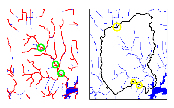
Figure 7 - Comparison of (a) baseline DEM-delineated hydrography and (b) baseline DEM-delineated watershed boundary with an edited USGS 1:100,000-scale DLG layer. Inconsistencies are circled.
All of the stream burning methodologies employed were able to replicate the hydrography network accurately (although one problem with representation of a complete constructed channel was observed with the Agree.aml algorithm). Results of the various techniques are shown in Figures 8 and 9. The delineated watershed boundaries for each case are depicted in bold. The red-shaded areas in the figures represent differences from the baseline delineation that were unexpected, i.e. not in the immediate vicinity of a baseline watershed boundary intersection.
The erroneous introduction of parallel streams was not a significant problem with any of the stream burning techniques. Only one instance of parallel streams was noted for an upper watershed tributary in Armand Bayou. There were two such occurrences in Dickinson Bayou (also for upper watershed tributaries). The use of the fine scale 1-arc second DEMs mitigates the number of these occurrences. The lack of any significant parallel streams may also be a testament to the use of similar scale vector and raster data sets for the analysis.
The Fillburn.aml algorithm introduced significant boundary distortions in the delineated watersheds. These are respectively shown in Figures 8a and 9a for Armand and Dickinson Bayou. The watershed boundary errors are due to the application of the universal stream-burning offset value to all in-stream grid cells. In the case of Armand Bayou, that value was 31 feet, resulting in an elevation differential of 32 feet between the land surface grid cells of the DEM and the in-stream cells. This result is consistent with earlier observations regarding the proportional relationship between the introduced elevation differential and the extent of flow direction variations.
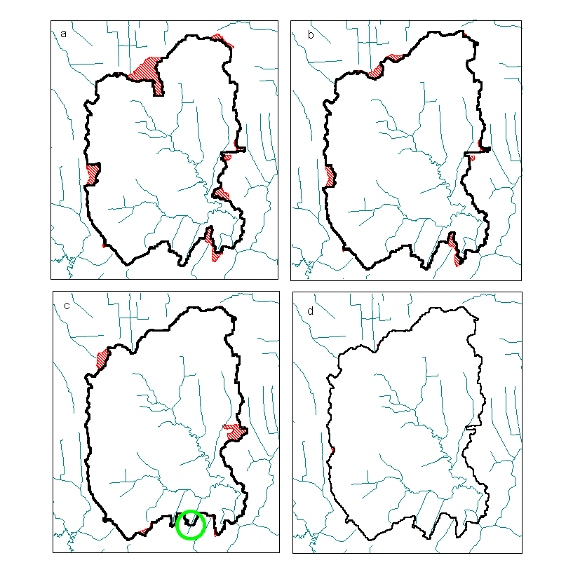
Figure 8 - Armand Bayou stream network and watershed boundary delineations produced using the (a) Fillburn.aml, (b) Expocurv.aml, (c) Agree.aml, and (d) Tribburn.aml hydrography integration techniques. Delineated boundaries are black. Observed watershed distortion errors are marked in red. One additional delineation inconsistency is circled in Figure 8c.
There was slight improvement in Armand Bayou watershed boundary accuracy (Figure 8b) with the use of the Expocurv.aml algorithm, but the Dickinson Bayou delineation (Figure 9b) showed a slight loss in total drainage area with the use of that procedure. Once again, a universal stream-burning offset value was applied to all in-stream grid cells, but the method of offset calculation, comparison of the exponentially fitted in-stream elevation values with the lowest neighborhood DEM elevation values, resulted in a smaller offset for Armand Bayou and a greater offset for Dickinson Bayou. An additional advantage of using the Expocurv.aml algorithm was a reduction in processing time. This was the result of less sinks encountered during the fill process.
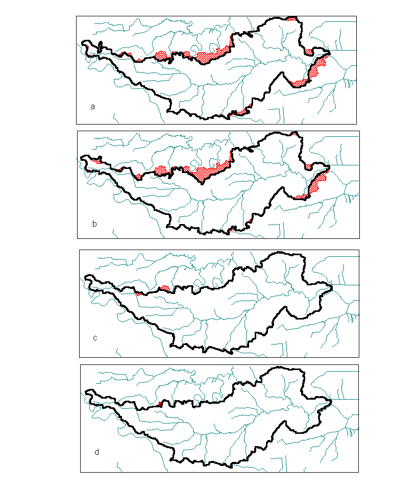
Figure 9 - Dickinson Bayou stream network and watershed boundary delineations produced using the (a) Fillburn.aml, (b) Expocurv.aml, (c) Agree.aml, and (d) Tribburn.aml hydrography integration techniques. Delineated boundaries are black. Observed watershed distortion errors are marked in red.
The Agree.aml algorithm was the most processing-efficient of all integration techniques applied and generally produced much better conformity with the expected watershed boundary. Only 3 significant distortion errors were noted for Armand Bayou (Figure 8c) and only two upper watershed discrepancies were observed for Dickinson Bayou (Figure 9c). One of the Armand Bayou errors occurred in the eastern edge of the watershed where a tributary is in close proximity to the watershed boundary. The Agree.aml methodology of smoothing elevations within a stream network buffer zone is the source of this error. The buffer zone value selected for these delineations (150 meters) smoothed all elevations within 5 grid cells of the stream network cells. As this tributary is within 5 cells of the Armand Bayou boundary, the boundary cells in that area were smoothed and a small patch of adjacent catchment cells was included in the drainage area.
A fourth Armand boundary distortion error, observed with the Agree.aml algorithm, occurred in the southern area of the watershed and is the result of the unsuccessful integration of a constructed channel tributary there. The post-hydrography integration fill process performed appears to have filled the in-stream cells back to the level of the land surface cells. This anomaly would have been avoided through the use of greater smooth and sharp offset values, although larger offset values would have introduced a greater potential for watershed boundary distortion.
The most accurate watershed boundary results were obtained with the Tribburn.aml algorithm (Figures 8d and 9d). However, the processing cost of achieving these results was significant. While the other three techniques had processing times between 13 and 21 minutes, Tribburn.aml took 6 1/2 hours to complete for Dickinson Bayou and over 7 hours to run for Armand Bayou. Variations in processing time are dependent on the density of the hydrography layer being integrated into the landscape. It should also be noted that, while watershed boundary results were notably improved over the other three techniques, some small watershed boundary distortions did occur with Tribburn.aml. Table 1 shows compiled statistics for each of the hydrography integration techniques applied.
[an error occurred while processing this directive]
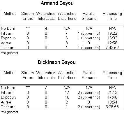
Table 1 - Results of various hydrography integration techniques performed for stream and watershed delineation of Armand Bayou and Dickinson Bayou
Conclusions
Four methods of integrating stream vector hydrography into a raster data set (DEM) have been presented and reviewed. Each of the methods provides for accurate digital replication of a receiving stream network. However, subsequent watershed delineations performed with the hydrography-enhanced DEM have been shown to produce results ranging from poor to excellent. The Fillburn.aml and Expocurv.aml algorithms, which apply a universal elevation offset factor to all in-stream grid cells, produced inaccurate watershed boundaries. Application of the Agree.aml algorithm resulted in general conformity with expected results, although some watershed boundary distortions were observed. The magnitude of these watershed boundary errors can be controlled by the Agree.aml user, through discriminate selection of hydrography buffer zone widths and smooth/sharp elevation offset factors. The Agree.aml algorithm provides the additional benefit of eliminating parallel streams from the hydrography-enhanced raster surface, although the use of fine-scale 1-arc second DEM data was also shown to mitigate the number of these occurrences.
Highly accurate watershed boundary delineations were produced through the use of the Tribburn.aml algorithm. The procedure�s iterative method of adjusting in-stream elevation values on a reach-by-reach basis throughout the hydrography network effectively generated expected watershed boundary locations while minimizing the elevation offset value applied to all in-stream grid cells. The Tribburn.aml algorithm is the least processing-efficient of all the methodologies examined, however. Watershed delineations for the small Armand and Dickinson Bayou watersheds were performed 20-30 times faster with the other three methodologies.
The Agree.aml and Tribburn.aml algorithms provide acceptable options for water resources modeling analyses that require geospatial data inputs to watershed and stream network models. For batch-type analyses where multiple watersheds may need to be assessed from a number of point locations in a dynamic fashion (such as an assessment of multiple water rights in large basin), the process-efficient Agree.aml is the more appropriate option. For cases where a single watershed delineation may be used for multiple assessments within the watershed (such as determination of statistical precipitation runoff distributions or nonpoint pollution loading assessments), the Tribburn.aml algorithm provides the most accurate delineation technique. Further investigation into the development of a process that combines the accuracy and processing efficiency of these two algorithms would be warranted.
The vector hydrography pre-processing required for use with either of these algorithms represents an intensive effort. The development of an automated technique for this processing would be an effort worthy of pursuit.
Acknowledgements
I would like to thank the following for continued consultation, review, and information exchange: Dr. David Maidment, Dr. Francisco Olivera, and the GIS hydrology research group at the University of Texas Center for Research in Water Resources; Dr. R. Srinivasan and Mauro DiLuzio at the Blacklands Research Center, Temple, TX; Dr. Seann Reed at the National Weather Service Hydrologic Research Laboratory; Ferdinand Hellweger at HydroQual, Inc.; Jennifer Benaman at Quantitative Environmental Analysis, Inc.; and James Edmonds and Prescott Christian at the Texas Natural Resource Conservation Commission.
References
Dewald, T.G. and K.S. Roth (1998), The National Hydrography Dataset - Integrating the USEPA Reach File and USGS DLG , In: Conference Proceedings: 1998 Esri User Conference, Environmental Systems Research Institute, Redlands, CA.
DiLuzio, M. (1999), Filling the Gaps Between USGS DEMs and the USEPA Reach File, In: Conference Proceedings: 1999 Esri User Conference, Environmental Systems Research Institute, Redlands, CA, forthcoming.
Garbrecht, J. and L.W. Martz (1997), TOPAZ: An Automated Digital Landscape Analysis Tool for Topographic Evaluation, Drainage Identification, Watershed Segmentation and Subcatchment Parameterization; TOPAZ Overview, U.S. Department of Agriculture, Agricultural Research Service, Grazinglands Research Laboratory, El Reno, OK, USA, ARS Publication No. GRL 97-3.
Hellweger, F.L. (1997), AGREE - DEM Surface Reconditioning System, http://www.ce.utexas.edu/prof/maidment/gishydro/ferdi/research/agree/agree.html as of July 1999.
Hutchinson, M.F. (1989), A New Procedure for Gridding Elevation and Stream Line Data with Automatic Removal of Spurious Pits, Journal of Hydrology 106, 211-232.
Hutchinson, M.F. (1996), A Locally Adaptive Approach to the Interpolation of Digital Elevation Models, In Proceedings: Third International Conference/Workshop on Integrating GIS and Environmental Modeling, National Center for Geographic Information and Analysis, University of California, Santa Barbara.
Hutchinson, M.F. (1998), ANUDEM Version 4.6.2, http://cres.anu.edu.au/software/anudem.html as of July 1999.
Jenson, S.K. and J.O. Domingue (1988), Extracting Topographic Structure from Digital Elevation Data for Geographic Information System Analysis, Photogrammetric Engineering and Remote Sensing 54 (11).
Marks, D., J. Dozier and J. Frew (1984), Automated Basin Delineation from Digital Elevation Data, Geo-Processing 2, 299-311.
Mizgalewicz, P.J. and D.R. Maidment (1996), Modeling Agrichemical Transport in Midwest Rivers Using Geographic Information Systems, Center for Research in Water Resources Online Report 96-6, University of Texas, Austin, TX.
O'Callaghan, J.F. and D.M. Mark (1984), The Extraction of Drainage Networks from Digital Elevation Data, Computer Vision, Graphics and Image Processing 28, 323-344.
Olivera, F. (1996), Spatial Hydrology of the Urubamba River System in Peru Using Geographic Information Systems (GIS), Center for Research in Water Resources, University of Texas, Austin, TX.
Quenzer, A.M. and D.R. Maidment (1998), A GIS Assessment of the Total Loads and Water Quality in the Corpus Christi Bay System, Center for Research in Water Resources Online Report 98-1, University of Texas, Austin, TX.
Reed, S. (1999), National Weather Service Hydrologic Research Laboratory, personal communication.
Saunders, W.K. and D.R. Maidment (1995), Grid-Based Watershed and Stream Network Delineation for the San Antonio-Nueces Coastal Basin, In Proceedings: Texas Water '95: A Component Conference of the First International Conference of Water Resources Engineering, August 16-17, 1995, American Society of Civil Engineers, San Antonio, TX.
Saunders, W.K. and D.R. Maidment (1996), A GIS Assessment of Nonpoint Source Pollution in the San Antonio-Nueces Coastal Basin, Center for Research in Water Resources Online Report 96-1, University of Texas, Austin, TX.
Strager, M.P., J.J. Fletcher, and C.B. Yuill (1998), Hydrologic Modeling for Acid Mine Drainage in West Virginia, In: Conference Proceedings: 1998 Esri User Conference, Environmental Systems Research Institute, Redlands, CA.
Texas Natural Resource Conservation Commission (1998), Technical Paper #3: Digital Elevation Modeling for the WAM and other TNRCC OWRM Projects, TNRCC, Austin, TX.
Texas Natural Resource Conservation Commission (1999), State of Texas 1999 Clean Water Act Section 303(d) List and Schedule of Development for Total Maximum Daily Loads, SFR-58/99, TNRCC, Austin, TX.
Author Information
William Saunders
Engineering Specialist
Texas Natural Resource Conservation Commission
MC-150
PO Box 13087
Austin, TX 78711-3087
Telephone: (512) 239-4535
FAX: (512) 239-1414
bsaunder@tnrcc.state.tx.us