
Illinois Public Library GIS Project
The Illinois Institute of Technology’s Galvin Library has partnered with the Illinois State Library and the regional library systems of Illinois to create a Geographic Information Systems (GIS) application that will enhance and support the work of the state’s public libraries.The overall goals of the Illinois Public Library GIS Project are:
1. To construct a comprehensive GIS database of Illinois public libraries and their service boundaries.
2. To use this database in concert with other GIS data (such as census statistics) to analyze library service in Illinois, to find the gaps and in the overlaps in service to Illinois residents.
3. To provide the tools and data for library administrators to make better administrative decisions for their libraries.
4. To provide public libraries in Illinois with the means to access this data for the purpose of determining if patrons reside within their library’s service area.
5. To train public librarians in the use of GIS.
6. To serve as a national model for implementing GIS resources and training in public libraries on a statewide level.
The IPL-GIS website is now accessible through the Galvin Library’s GIS webpage at http://gis.iit.edu.

The need for better data
Before IPL-GIS, there existed no up-to-date, library-maintained statewide spatial record of public library and library district service boundaries in Illinois.There was no quantifiable way to determine how well Illinois residents are served by their public libraries.It was difficult for public library and regional library administrators to analyze the demographic breakdown of their constituent populations.There was, and continues to be, a great need for better information about the service boundaries of public libraries in Illinois and about the populations served by particular libraries and library systems.
The IPL-GIS project will provide library administrators at the local and statewide levels with raw data from which a greater understanding of the demographic profiles of their constituents can be discovered.This project will also present information in a uniquely organized and accessible manner, through the very visual realm of interactive maps.At the completion of this project, libraries and their organizational bodies will possess a new tool and set of data resources which they may employ for a variety of applications, from helping a user determine in which library service area he or she lives to making library administrative decisions regarding types of services to offer or to target specific populations for a fundraising campaign.Non-resident law
IPL-GIS will also assist library administrators in determining whether or not they will participate in Illinois’ new “non-resident” law.Illinois Public Law 92-0166 stipulates that "a person residing outside of a public library service area must apply for a non-resident card at the public library located closest to the person's principal residence." The purpose of the new law gives Illinois residents living in an area without tax-supported public library service with an opportunity to acquire a non-resident borrower's card from the closest public library to the individual's residence; and be afforded all the services as those provided to residents receiving services from the issuing libraries. The current rules define "closest public library" as the "participating public library that serves a portion of the township or school district where the non-resident resides. If no public library serves a portion of the township or school district where the non-resident resides, the non-resident can purchase the card at any participating public library in the county where the non-resident resides."[1]
Libraries in Illinois have the option to participate in the program, and many administrators are concerned that the new law will add more stress to limited library budgets. Librarians in heavily populated regional systems are also faced will the problem of deciding how to divide up the non-residents in areas where several public libraries exist within a single school district.
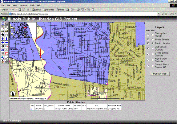
IPL-GIS provides the data to help administrators make better informed decisions in regards to the new non-resident law.IPL-GIS layers together census data, public library and library district boundaries, as well as school district boundaries, so that library administrators determine the number of people living in unserved areas before making their decisions.
Building the database
The Illinois Public Library GIS Project has been funded by two Library Services and Technology Act (LSTA) grants, administered by the Illinois State Library. Initially, a pilot project was created for two of the twelve regional library systems in Illinois. The purpose of the pilot project was to determine the best practices for collecting, converting, and managing this information.
The project director originally hoped to collect library boundary information from the libraries themselves. However, during the pilot project, response rates were low, and in the statewide implementation phase, it was determined that the best source of public library and library district boundaries was the Illinois Department of Revenue.
Data collection
There are 771 public library and library districts in Illinois.Public library boundaries match those of their local municipalities. Public library districts, on the other hand, may have boundaries that extend beyond their local municipality.To obtain the necessary data, the project team first acquired the library district boundary shapefile from the state Department of Revenue.Secondly, they filtered out municipality boundaries from a statewide set for the remaining 429 “local” public libraries.The Department of Revenue also provided shapefiles of school district boundary data.All data was from tax year 2000.
The data collection phase of this project took several months.A high percentage of libraries’ boundaries were represented by several splinter polygons.These polygons were merged together so as to provide the user with a better sense library boundaries.
Application Features

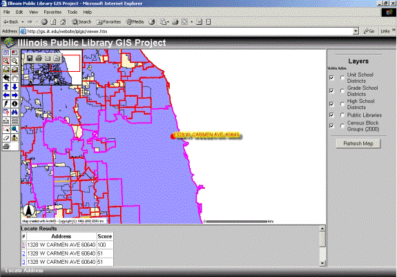
One of the most useful features of IPL-GIS is the user’s ability to geocode his or her address.Because the public library and library districts boundaries are represented as polygon shapes, the user is immediately able to determine if the entered address falls within an established boundary.
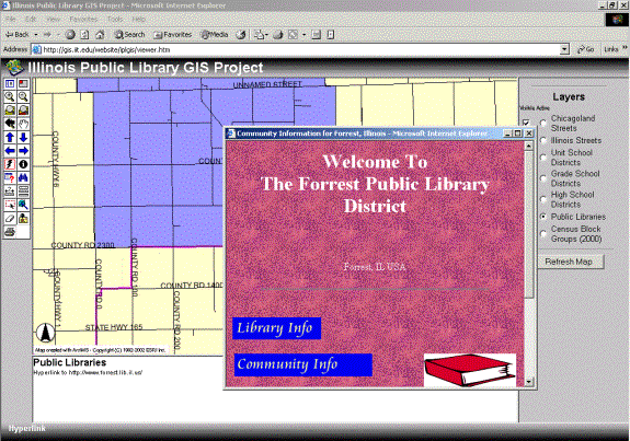
All of the polygons are hyperlinked to that particular library’s website, so that the user has immediate access to information about his or her public library.

The user has access to school district and census files as well.These files allow for more detailed understanding of the library’s community and information that will assist administrators in resolving questions about non-residents that may live within a shared school district boundary.
As of the Esri conference, the IPL-GIS website is active and available through the Galvin Library GIS website (http://gis.iit.edu).However, the site is being reviewed by public librarians around the state and will continue to see interface improvement.Online help documentation is being created and will be integrated into the site.
Partners
The Galvin Library of Illinois Institute of Technology is the lead partner in the project, providing equipment, personnel, and data resources.Galvin Library is responsible for contacting public libraries, making use of the existing and requested resources to create the spatial database, documenting the process, and making that information available through the interactive map web site. The project will benefit the Galvin Library by giving the project team the experience and recognition of creating a resource for librarians that will be used around the state and may serve as a national model.
The Illinois State Library has provided financial support for the project through LSTA funding.Because the State Library will benefit greatly from the information gathered in this project, the project team will work in close communication with Illinois State Library staff to ensure that the process proceeds in accordance with the State Library’s information needs.Illinois State Library will also evaluate the project to determine if and when the second phase of the project will begin.
The public libraries of Illinois will partner with the project team to provide the most accurate, up-to-date service boundary information available.The project team will work closely with a focus group of public library administrators, one set of target users for this project, to ensure that their information needs are being met in the development of the internet application.
Conclusion
The Galvin Library has been a leader in promoting and using GIS technology in libraries. We have built upon our current resources and expertise in GIS to build an information tool that will serve Illinois residents, librarians, and administrators by providing access to library legal boundaries and several other GIS datasets through an interactive website.The Illinois Public Library GIS Project has produced an information resource for use by residents, librarians, and administrators in Illinois.This resource is dynamic and is now available to users over the Internet as an interactive map website. http://gis.iit.edu. This project will also serve as a prototype for national efforts to create a GIS database of public library service boundaries.
Galvin Library GIS Lab
The partnership between the Illinois State Library and the Galvin Library GIS Lab is a natural fit.The GIS Lab was initially funded by a 1998 Library Services and Technology Act grant administered by the Illinois State Library. The lab houses GIS and global positioning systems (GPS) hardware, software, and datasets and serves the IIT community as well as the general public.Workshops are given frequently, and the Lab now serves over 100 people a month. Not only is GIS becoming part of the academic curriculum at IIT, but several internal administrative departments, such as alumni relations, community development, and computing and network services, regularly make use of the Lab as a information and mapping resource for marketing campaigns and other special projects.
About the Author
Alison Atkins Denton, Assistant Dean for Special Projects and GIS at the Galvin Library directs the Illinois Public Libraries GIS Project.Ms. Denton previously oversaw the development of the GIS Laboratory and Resource Center, made possible by 1998 LSTA grant monies.As director of the GIS Laboratory, Ms. Denton has developed training workshops, established many contacts with the local GIS community, works as a GIS consultant, and has presented at numerous library and GIS conferences. Please feel free to contact Ms. Denton at denton@iit.edu if you have further questions.
[1] “Public Library Non-Resident Services.”Suburban Library System website.http://www.sls.lib.il.us/sls/plservices.html#faq