Abstract: A five-year study was conducted on the experiences and support necessary for in-service teachers to effectively integrate GIS in their classrooms. Guiding questions included 1) what in-service structures and formats best encourage integration; and 2) will teachers' participation in extensive in-service affect their confidence level to use GIS and/or their attitudes toward GIS as an effective classroom tool. Assessment measures included 1) contrasting the level and type of teacher use based on participation in web-based discussions and lesson plan analyses; and, 2) teacher self-ratings on a Likert confidence and attitude instrument. The large majority of participants planned and implemented GIS lessons in meaningful contexts.
The development of national and state standards which call for more relevancy and examples of real world applications as well as more emphasis on problem solving skills and inquiry has generated exploration of new instructional materials and strategies. Geographic Information Systems (GIS) is a tool that is being used extensively by researchers, scientists and planners to inform decision making about real world problems. Application of this technology to such concerns as the environment, agriculture, land use management and infrastructure development is occurring on local, regional and national levels. Until recently it was not feasible for educators to use this spatial data resource because the cost of the software was prohibitive and the size of the data files was too large to load on the personal computers used in most school settings. Demand from public and private sectors coupled with spiraling innovations in technology have resulted in the recent introduction of software which can be used to manipulate spatial data on personal computers. While the functional capabilities and methods of spatial data encoding vary among venders, geographic information systems are powerful tools for storing, analyzing, displaying and processing spatially referenced information. Software companies such as Environmental Systems Research Institute, Inc. (Esri) have produced software bundles for school systems at affordable educational prices.
Educators are beginning to investigate productive uses of GIS in teaching/learning environments. Examples are varied and range from a water sampling study by Hispanic girls along the Carson River (McGarigle 2001) to mapping hazardous materials storage sites in Chelsea, MA (Paul, W & Hamilton, W. 2000). Other opportunities for substantive, authentic investigations in earth science, geography, life science, physical science and mathematics are clearly available. Additionally, partnerships are emerging between schools and institutions of higher education to tackle the challenge of identifying and creating accessible data sets and developing exemplary instructional materials (McClurg & Lerner 1998; Lyon 1997; Rooney 1997; Slater & Fixen 1998).
Investigations examining the claims that novices can use GIS technologies as problem-solving tools and that these tools can enhance student understanding are informing instructional practices (Audet & Abegg 1996; Ramirez 1996). Some schools are instituting curricula that require GIS technologies in at least two different modes: GIS education and GIS in education (Palladino & Goodchild 1993; Ramirez 1996).
While initial users of GIS were often self-taught it is not realistic to assume that teachers, while working full time in demanding jobs, will be able to incorporate these new strategies into their professional repertoires. Ample evidence exists to suggest that teachers need information, theory, modeling, support, and feedback to learn a new teaching strategy (Joyce & Showers 1988). Teacher time is another key issue (Fullan & Miles 1992). Bohlin and Hunt (1995) reported an increase in confidence and attitudes and a decrease in computer-anxiety when pre- and inservice teachers were enrolled in courses that met over a longer period of time. Not only do teachers need time to learn the skills, they need time to experiment, to reflect, to revise and to integrate new understandings (Loucks-Horsley, Hewson, Love & Stiles 1998).
Professional development opportunities, such as extended workshops and institutes, are typically the forum for teachers to learn new teaching strategies. Loucks-Horsley, et al. (1998) describe five implementation requirements for such experiences to be effective. These include: 1) expert knowledge through a leader or facilitator; 2) time away from the workplace, with arrangements for substitutes or stipends, to free teachers from their regular duties; 3) a curriculum or syllabus to inform the participants about the content; 4) Access to resources and materials, i.e. classroom materials, texts, tutorials, and software; and 5) incentives such as stipends or graduate credit. Such experiences are necessary for teachers to integrate GIS in their classrooms.
The EdGIS Conference final report (1995) supports the need for effective professional development in using GIS in the classroom. It states, "For GIS to have a broader impact on education, progress needs to be made in several key areas of implementation: development of exemplary curriculum materials... teacher training, and dealing with issues of equity of access" (p. 19). This call for quality teacher training is supported further by a survey of educators using GIS in their classrooms. Audet & Paris (1997) found that 77% of respondents strongly agreed that teacher training is necessary before introducing GIS in the classroom. In addition, 75% of those surveyed agreed or strongly agreed that teaching with GIS requires new teaching methods.
The purpose of this study was to develop effective professional development experiences for teachers to learn how to use GIS resources in their classrooms to increase and enhance student achievement in areas of geography, science, mathematics, technology and art. To accomplish this goal, workshops were conducted, assessed and revised in an iterative process.
The efforts to provide Wyoming teachers with content background and skills to use GIS in the classroom began in 1995 through the development of the Earth System Science Internet Project (ESSIP). The primary goal of this project was to form a collaborative partnership between scientists and science educators at the University of Wyoming and K-12 teachers throughout Wyoming. The project focused on creating eight authentic learning experiences through the use of remotely sensed data, GIS, spatial data accessible over the Internet, and collaborative lessons requiring participation through the Internet across multiple sites.
In 1996, fifteen 6th-12th grade geography and science teachers from five school districts participated in a week-long workshop at the University of Wyoming to learn the basics of ArcView GIS (Esri, Inc.) and test the GIS module lessons. As part of the module development process, the teachers were asked to test each of the lessons in their classes and provide feedback to the project directors during the 1996-97 academic year. To assist the teachers in this process, continual support from GIS technology specialists on the ESSIP staff was provided in the form of personal visits, e-mail, and telephone conversations.
Classroom observations and teacher interviews provided the bulk of the data from the first iteration. Each of the teachers was visited during the school year and interviewed about the strengths and weaknesses of the lessons, obstacles to implementation, and suggestions for improving various aspects of the project. The teachers were then brought back together in the summer of 1997 to discuss these same issues.
A second iteration of the workshop was conducted over the 1997-98 academic year. Several changes were made to the content and format of the workshop based on the feedback from the first workshop participants. As with the first iteration, two part-time personnel were available to assist teachers during the transfer of these activities to the classroom. They were available by phone, e-mail and personal visits to the school sites to assist teachers with any hardware or software problems they might encounter and to model teaching in participants' classrooms.
A third iteration of the workshop was then developed and used, with several modifications, for five additional workshops conducted between 1999 and 2001. The modifications were made based on feedback from the participants of the second workshop and discussions with the workshop presentation team. Again, support was provided for each of the workshop participants.
Assessment measures included classroom observations, interviews, teachers' ability to demonstrate their skill to workshop leaders and cohorts, and analysis of: 1) a web-based discussion; 2) lesson plans; and 3) student projects generated in teachers' classrooms. Teachers were also asked to rate themselves on a 15-item Likert type scale at the beginning and the end of the workshop. Thirteen of the items dealt with participants' level of confidence regarding their ability to use and or to implement GIS in the classroom. Two of the items were statements related to participants' attitude toward GIS as a tool in the teaching/learning environments. This instrument was designed by the authors and distributed to a five-member panel for review. Modifications were made and the questionnaire was redistributed to the panel and approved prior to use as an assessment tool for the in-service activities.
Observations from classrooms during the first iteration provided information about the introduction of GIS to 6th-12th students which was then transferred to introducing the software to teachers participating in the second iteration. Students were observed using GIS as an exploratory tool, so the second iteration was planned to provide more opportunities to explore data. In addition, student groups of two appeared to work best where resources were limited, but a 1:1 student-to-computer ratio was ideal, so greater emphasis was placed on each participant having access to a computer in the second iteration.
Along with observing the students, the 15 teachers were tracked and interviewed regarding their use of the modules and general participation in the project. Five teachers expressed hardware obstacles as the primary reason for not fully participating. Seven others described unrelated commitments as the main obstacle in participation. Only three teachers felt satisfied in their implementation of the GIS lessons. Each of the 15 teachers had volunteered and made a commitment to participate, but a stronger incentive was needed to encourage full participation. As a result, the second iteration was offered for graduate credit from the University of Wyoming.
Direct feedback from the participants after the first iteration proved most helpful in redesigning the second workshop format. The participants' suggestions which were directly implemented in the second iteration included: 1) creating a non-computer-based introduction to GIS concepts such as using transparencies to demonstrate overlaying themes and querying; 2) allowing students to create their own data layers to increase motivation and emphasize the local focus of GIS; 3) spending more time discussing databases, queries, and the syntax of querying; 4) addressing the need for complying with state and national standards; 5) learning how to customize the lesson plans; 6) involving more teachers from other districts; and 7) integrating other content areas. The participants also provided feedback about difficulties in accessing computers with sufficient memory or other hardware requirements, garnering support from administrators and colleagues, and simply remembering how to use the software due to the lag-time between the workshop held during the summer of 1996 and implementation of the lessons several months later during the 1996-97 academic year.
This feedback was used to make several modifications for the second workshop. First, the format of the workshops was modified from an intense week-long workshop to a seven day, three-part workshop extended over a six month period. This was to give the participants opportunities to test and refine their skills at home and in the classroom between sessions. The purpose of the intermediate session was to provide reinforcement, remediation, and continued development in the midst of implementation efforts.
Second, teachers were sought from the areas of geography, mathematics, science and art to provide a greater emphasis on interdisciplinary connections of using GIS. The resulting content composition of the teachers (5th-12th grade) in the second workshop consisted of science (7), geography (4), elementary (4), math (3), art (2), and history (1). Third, the content of the workshop was expanded. The first part of each workshop session was devoted to sharing the teachers' experiences using the software and to discussing solutions to any problems that had arisen. Introductory remote sensing concepts and the use of Global Positioning System (GPS) were also added. GPS skills and concepts were added so that teachers and their students could generate their own data sets. Teachers also viewed video examples of 6th - 12th grade students using GIS software in school contexts and participated in interdisciplinary activities which incorporated GIS as a tool. These interdisciplinary activities explored the integration of artistic concepts, such as the use of points, lines, shapes, colors and design principles, in creating and interpreting maps. Fourth, teachers were asked to bring their own computers to the workshop sessions and learned to install the ArcView software and data sets on their own machines. This allowed teachers to gain a greater understanding of the installation process and file structure of the software. Fifth, all the participants were expected to complete homework assignments during the periods between workshop sessions. These assignments included identifying state and district curriculum outcomes and standards that could be addressed by using GIS/GPS, developing, teaching and evaluating lesson plans for their students, and posting their ideas, assignments and comments on the ESSIP web-based discussion site.
Thirty-six teachers initially registered for the second workshop, but only twenty-one completed the extended seven-day series, nineteen of which took the course for credit. Each of these nineteen teachers identified relevant district and state outcomes and standards as well as posted ideas on the discussion site. Twenty teachers developed lesson plans, with fourteen being able to implement and evaluate them. Three of the teachers who were unable to implement their plans cited lack of access to capable hardware and three stated that they did not have sufficient time to test their plans.
A follow-up workshop was conducted in February 1999 for the participants in the second iteration. Thirteen teachers stated at that time that they were able to continue implementing GIS and GPS after the completion of the course. Two others were still set back by hardware and time obstacles but stated their intention to forge ahead in their efforts. The remaining six had discontinued using GIS in their classrooms.
A third iteration of the workshop was implemented in the spring of 1999. The changes consisted of 1) reducing the contact period to six days instead of seven, through the elimination of remote sensing content; 2) conducting a field trip to model the data collection and mapping process; and 3) the use of a tutorial, Getting to Know ArcView GIS (1999), to serve as a resource throughout the course of the workshop period. One workshop was conducted in the spring of 1999, three workshops were conducted in the spring of 2000, and one workshop was conducted between February and Octorber, 2001. Of the 74 teachers registered for these workshops, 69 (93%) completed the series. Fifty-nine teachers (80%) were able to complete the assignment to develop and implement lessons plans using GIS and/or GPS technologies. The remaining teachers either dropped out of the workshops or cited insufficient time as the reason for not completing this assignment.
Along with teacher participation and workshop development, this study also examined the level and type of use by the teachers who participated. As might be expected by the spread of grade levels and content areas, the complexity of the lesson plans varied. Generally, the elementary and middle school teachers as well as the art teachers used GIS to conduct simple visual investigations without resorting to the Boolean or other intensive querying capabilities of the software. For instance, a sixth grade teacher designed a lesson using GIS to introduce her students to the five themes of geography by looking at such things as the characteristics and features of a place. An art teacher asked her students to use GIS to investigate land forms and land marks then create their own land mark stamps. The students then used these stamps along with principles of design and printmaking skills to create new maps of the areas under investigation.
The junior high and high school science, geography and mathematics teachers tended to use more of the software's functionality. For instance, a high school biology teacher designed a lesson to provide her students with and introductory experience to ArcView and risk assessment through the development of an expedition route through a local watershed. Students had to consider topography, landownership, distance, and mode of travel. As part of the assessment, students created layouts of the expedition route. Extension activities included physically exploring the watershed, using a GPS unit to mark data collection points. Another high school teacher designed a lesson in which students used United States Forest Service data to create a map of a hiking trail. The resulting map displayed difficulty levels along the trail determined by elevation and slope.
When given the opportunity, the participants of the second and third workshop iterations were able to develop useful, appropriate lessons involving GIS. Comments from these participants indicated that they were excited about using GIS to teach content they were already responsible for teaching and saw greater potential for integrating this technology into their teaching practice.
Teacher surveys were also used to evaluate the workshops and participant growth. Initially, the survey consisted of 14 Likert-scale items. For the third workshop iteration, a fifteenth item was added. Although 91 participants completed the workshops, the number of participants completing all items on the survey varied. A maximum of 77 teacher participants in the second and third workshop iterations completed both the beginning and ending survey. Table 1 summarizes the beginning and ending means for the pre-workshop/post-workshop rankings on each of the fifteen items in the survey. Examination of these descriptive statistics revealed participants' confidence in their ability to use GIS and their attitude toward GIS as a useful tool in the classroom increased substantially. The mean self-ratings at the end of the six month in-service were quite high with a range of 5.7 to 7.72 and a median of 6.63 on a ten point rating scale. Statistically significant gains were detected (p<.001) for the items measuring participants' level of confidence in their ability to use GIS. Statistically significant gains were detected (p<.001) for both items assessing participants' attitudes toward GIS as a useful tool in the classroom.
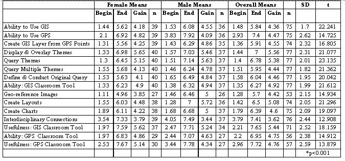
Table 1: Mean scores and summary of t-tests on the level of confidence and attitude survey.
Designing effective professional development is a complex task. The purpose of the learning opportunity, the content, and the needs of the participants must be matched with an appropriate strategy or combination of strategies for promoting learning and change. Then the professional development must be implemented in such a way as to provide expertise, support learning, and encourage participation through incentives (Loucks-Horsley, et al. 1998).
When introducing new technologies, additional factors must be considered, such as providing technical and moral support as well as a sufficient time period to enable the learners to become comfortable with the technology. The learners must also see the possibilities for applying and integrating the new technology into existing curricular structures. As Audet & Paris (1997) stated, there is a distinction between "knowing how to operate a GIS and knowing how and when to apply GIS to solve problems" (p. 300). Appropriate professional development would allow teachers to learn how to manipulate GIS and how to apply it meaningfully in the classroom setting.
All three iterations of the workshop in this study shared characteristics and elements such as workshop instructional methods and hands-on activities, and technical and moral support structures. The first two iterations included follow-up sessions. Some of the teachers in all the workshops experienced technical obstacles, lack of administrative support, and lack of sufficient time to fully implement lesson plans involving GIS.
The second and third iterations of the GIS workshop, however, draw closer to meeting the effective professional development models described by Loucks-Horsley, et al. (1998) than the first iteration. They appear to have been more effective in promoting lasting change in teaching practice in terms of ability to use GIS and implement it into the classroom. The extended time frame of the workshops, stronger incentives through credited course requirements, interdisciplinary connections, outside assignments to design and test lessons, and on-going communication using the web-based discussion site were all significant changes from the first iteration. One or a combination of these changes may be the primary factor(s) for increasing the effectiveness of the second and successive workshops. Further interviews of the participants need to be conducted to identify specific aspects of the workshop that led to changes in their practice.
While teachers' confidence in their ability to use GIS grew significantly, there was variability in their confidence to use different GIS features. They were most confident in their ability to display and overlay themes, conduct queries on existing themes, produce layouts and charts communicating results of their investigations, and produce new layers based on data collected during field experiences. They indicated less confidence in their ability to geo-reference images and to define and conduct original queries. Geo-referencing images is very important for users who wish to superimpose existing remotely sensed images. Defining and conducting original queries is an important skill as users work on problems situated in the real world. Continued refinement of the in-service experiences in these important areas is clearly indicated. While not a part of the original intent of the survey, the obvious difference in confidence level of males and females is perplexing. From the perspective of the workshop leaders there was no difference between genders in their ability to use and apply these technological tools.
Teachers' ending attitudes toward using GIS as a tool to support learning were extremely positive (7.72 on a 10 point scale). Will these positive attitudes and high level of confidence result in teachers using these tools in their classrooms? What kinds of learning experiences are being supported through the use of these tools? Have teachers changed their instructional style as a result of using these tools, and if so, how? Are they participating in the discussion/support web site? Do they need other kinds of continuing support? What kinds? These questions and others will continue to be addressed by ongoing work.
Audet, R., & Abegg, G.L. (1996). Geographic information systems: Implications for problem solving. Journal of Research in Science Teaching, 33(1), 21-45.
Audet, R., & Paris, J. (1997). GIS implementation model for schools: Assessing the critical concerns. Journal of Geography, 96(6), 293-300.
Bohlin, R.M., & Hunt N. P. (1995). Course structure effects on students' computer anxiety, confidence and attitudes. Journal of Educational Computing Research, 13(3), 263-70.
EdGIS (1993). First national conference on the educational applications of GIS (EdGIS): Conference report. Washington, DC: National Science Foundation.
Fullen, M.G., & Miles, M. (1992). Getting reform right: What works and what doesn't. Phi Delta Kappan, 73(10), 745-752.
Getting to know ArcView GIS (3rd ed.). (1999). Redlands, CA: Esri Press.
Joyce, B., & Showers, B. (1988). Student achievement through staff development. White Plains, NY: Longman Inc.
Loucks-Horsley, S., Hewson, P.W., Love, N. & Stiles, K.E. (1998). Designing professional development for teachers of science and mathematics, Thousand Oaks, CA: Corwin Press, Inc.
Lyon, J. (1997). GIS in education: A model for integration of geographic information systems into K-16 education. [Available On-line] http://danenet.wicip.org/gisedu/about.html.
McClurg, P., & Lerner, H. (1998). Earth system science internet project widens Wyoming students' world, Geo Info Systems, March, 34-37.
McGarigle, B. (2001). Mapping a broader appeal. Government Technology, [Available On-line] http://www.govtech.net/magazines/story.phtml?id=2530000000001253.
Michelsen, M.W., Jr. (1997). In the Hands of Babes. Earth Observation Magazine, 6(5), 18-20.
Palladino, S. & Goodchild, M.F. (1993). A Place for GIS in the Secondary Schools? Lessons from the NCGIA Secondary Education Project. Geo Info Systems, 3(4), 45-49.
Paul, W. & Hamilton, W. (2000). Hazmat. In R. Audet & G. Ludwig (Eds.), GIS in Schools (pp.13-21). Redlands, CA: Esri Press.
Ramirez, M. (1996). A driving force in technology education: Geographic information systems (GIS). TechTrends, 41(2), 34-36.
Robinson, L. (1996). Plotting an island's future. Geo Info Systems, 6(5), 22-27.
Rooney, P. E. (1997). A spatial tool for schools. Hands On!, 20(1), 4-5.
Slater, T.F., & Fixen, R.L.(1998). Two models for K-12 hypermediated earth system science lessons based on Internet resources. (Learning cycle model and the investigation/experimentation model). School Science and Mathematics, 98(1), 35-40.
Alan Buss
Elementary/Early Childhood Education
University of Wyoming
Box 3992
Laramie, WY 82071
United States of America
Ph: 307.766.3972
abuss@uwyo.edu
Patricia McClurg
College of Education
University of Wyoming
United States of America
patmc@uwyo.edu
Lydia Dambekalns
Secondary Education
University of Wyoming
United States of America
lydart@uwyo.edu