Wim Boxsem
The most densely populated part of the Netherlands has a risk of flooding by water of the North Sea and the rivers Rhine, Meuse and Schelde. Some might remember the TV-images of last year and the decision of the local government to evacuate more than 250,000 people in the river area. The safeguarding of the people in the Netherlands from the water has a very high priority for the local government as well as the national government. In January 1996 the Waterdefences Act was passed the Dutch Parliament and Waterboards and governmental water managers (e.g. Directorate IJsselmeer Area) are now obliged to set up dike-records and management registers to facilitate management and maintenance departments to ensure the safety of primary dams and dikes in the Netherlands in the future. In our country we have 600 km of dikes which protect us against seawater; 650 km of riverdikes and more than 1000 km of little polderdams and polderdikes.
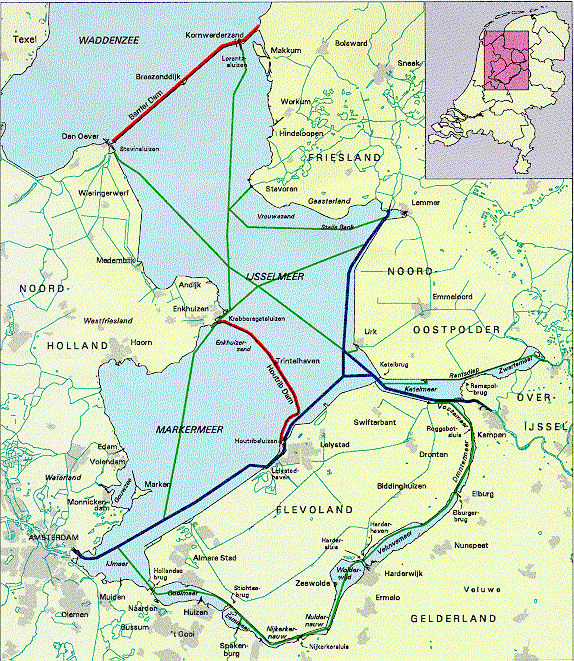
In our area the governmental watermanagement Directorate-General of Public Works and Watermanagement (RWS): Directorate IJsselmeer Area has the responsibility for the Barrier Dam in the northern part of the IJsselmeer area and the Houtribdam in the centre of the area (see Figure 1 IJsselmeer Area). At the end of 1993 the Directorate IJsselmeer Area in cooperation with the Survey Department started a pilot-study with data of the Houtribdam, to investigate the possibilities of using GIS to set up a dike-record. The pilot turned out to be useful and very promising, so in 1994 we started the DIJKGIS-project.
Besides the Directorate IJsselmeer Area, some Waterboards in the
northern and western parts of the Netherlands also started to
investigate the possibilities of GIS for setting up dike-records
and management registers. A meeting with some representatives
of the northern Waterboard Dollardzijlvest was the start of a
cooperation between Waterboards and the Directorate IJsselmeer
Area which is beyond comparison. The basic concept for a management
register was proposed in 1991 by the Union of Waterboards in which
the most useful elements of dike and dam management were laid
down. This contribution of the Waterboards proved to be very valuable
to the project.
Our organisation RWS and the participating Waterboards ( Dollardzijlvest
- northern part, Delfland -western part - and Amstel/Vecht - near
Amsterdam) decided to ask GIS consultants to build an application
working under ArcInfo and ArcView with an open RDBMS-database.
Half of the total cost was paid by RWS and half by the Waterboards.
The DIJKGIS-project was developed by:
In January 1995 the Guiding committee DIJKGIS accepted the project plan for DIJKGIS. The activities were divided into 18 stages. These stages were clustered into 4 major activities resulting in 4 milestones. Within 2 weeks the GIS consultants would have to deliver the general design. The data model DIJKGIS should be completed within 4 weeks. The programming and user-interface should be delivered 12 weeks after starting the project. Acceptance and termination of the project was scheduled 21 weeks after the start.
The general design gives a description of:
The future working environment gives an account of why the DIJKGIS-project was initiated, how data will be provided and which GIS-support was chosen. The database-structure includes a data-dictionary: a detailed data model with entities and sub-entities, attributes, relations between entities, tables, geometric and administrative data. All these matters are extensively described in the data model for DIJKGIS, a book of more than 65 pages.
The standard functionality consists of 7 main function groups: management, drawing, adding new records, changing records, selecting records, consulting and presenting data
The first results of programming were delivered in October 1995. The scheduled time was exceeded by 50 %, due to technical problems related to the data model and to the programmers unforeseen holidays, which had not been accounted for in the original time schedule. The end-users had tested the programming results and more than 150 errors were detected. Of these errors, 25 % can be identified as desired changes, 40 % may be called minor errors and 35 % must be indicated as fatal errors.
In a fruitful dialogue with the GIS consultants most errors were repaired and in March 1996 DIJKGIS 1.0 was completed. Unfortunately this was not a version to be used in the field, but a management version. This year and in the coming two years our organisations will investigate how we can obtain an end-users version of DIJKGIS: DIJKGIS 2000.
In 1994 the total cost of the DIJKGIS-project were estimated at DFL 100,000. This amount was paid to the GIS consultants, but there are indications that the total costs for the first part of this project will rise as high as DFL 300,000. The benefits are great: we have started a previously unknown cooperation with Waterboards and this cooperation will be continued in the future. Another result is the start of a project between local and governmental water managers to work on an uniform data dictionary for watermanagement in the Netherlands.
Within a couple of years the end-user of DIJKGIS will receive an user-friendly application called DIJKGIS 2000. Within this application the dike-manager may consult and edit data. Besides these very useful tools he may extract data and information from the DIJKGIS database of dikes and dams which are outside his control, for the required 5-yearly report on the safety condition of the dikes and dams.
DIJKGIS 2000 - a GIS application build with ArcInfo and ArcView from Esri - could be an useful tool to all dike and waterdam managers in the world.
Projectdossier DIJKGIS LOGISTERION, Rotterdam ,April 15,1996
DIJKGIS / Een applicatieprogramma voor beheer en onderhoud van waterkeringen Evaluatierapport Stuurgroep DIJKGIS RWS Directorate IJsselmeerArea, Lelystad , July 23, 1996
RWS Directorate IJsselmeer area
Wim Boxsem (coaching DIJKGIS)
Postbox 600
8200 AP Lelystad
phone: + 31 320 299 111
E-mail : Internet: W.BOXSEM @RDIJ.RWS.MINVENW.NL
GIS consultants
LOGISTERION AUTOMATISERING
Eric Sussenbach (programming DIJKGIS)
Postbus 29080
3001 GB Rotterdam
phone: + 31 10 2170 700
GEON
Chris Stiggelbout (data model DIJKGIS)
Postbus 3037
9701 DA Groningen
phone: +31 50 5749 760
Figure 1 IJselmeer area, showing waterdams and shipping routes,
also Barrier Dam and Houtrib Dam.