Technology
Groundwater management in Copenhagen
Hans-Martin Friis Møller
RAMBØLL, Virum, Denmark
Lars Møller Markussen
RAMBØLLl, Virum, Denmark
1. INTRODUCTION
Drinking water is abstracted from the groundwater in the middle of Copenhagen and groundwater management is a necessary part of infrastructure projects in Copenhagen as these projects include groundwater lowering.
RAMBØLL has been consultant on the major infrastructural projects in Copenhagen during the last decade; i. a. the Øresund Link, Ørestaden, enlargement of Copenhagen Airport, establishment of new waste water treatment plants, Copenhagen Metro, as well as for the public water supply.
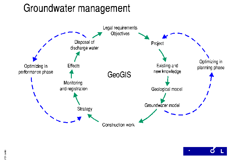
The groundwater management circle below is RAMBØLL's recipe for groundwater management in Copenhagen. Furthermore an understanding of the urban hydrological circle is essential - see figure 2.
RAMBØLL's groundwater management tools are
- GeoGIS, which is a GIS package including a large geo database with chemical data, discharges, groundwater levels etc.
- a 3-D interpreted geological model covering the Greater Copenhagen area
- 3-D groundwater models for the same area.
The following text gives a short description of RAMBØLL's ground water management in Copenhagen. The Øresund Link project is described as an example.
Figure 1 The groundwater management circle
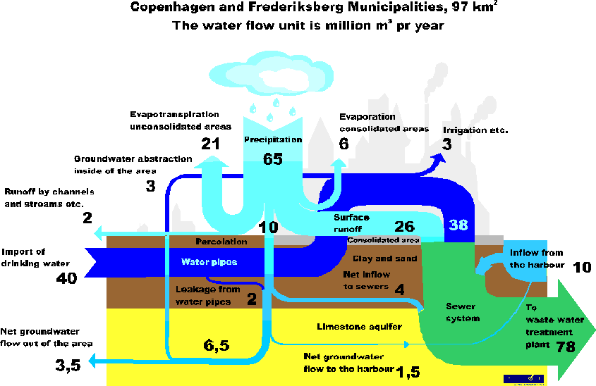
Figure 2 The urbane hydrological circle
2. LEGAL REQUIREMENTS
The legal requirements in Copenhagen are especially related to protection of the public water supply, possible damage to buildings, pollution, and discharge of water to recipient.
Two of the overall environmental groundwater action plans in Copenhagen state that during groundwater lowering, the present withdrawal of groundwater shall be maintained to the greatest extent possible and the water quality may not deteriorate significantly.
3. DEVELOPMENT OF MODELS
3.1 Geological model
A large relational geo database has been developed for storage of geological, geotechnical and soil related environmental data. The database consists of over 5000 borings all over Copenhagen coming mainly from geological and environmental investigations carried out by public institutions and private companies. The borehole data is backed by geophysical data from borehole logging and site investigations.
A 3-D geological model has been developed based on information from the geo database. Digital mapping of both the quaternary deposits and the prequaternary surface was carried out. The mapping was carried out in scales from 1:500 to 1:25.000 according to the density of data information. The quaternary sediments have been divided into approximately 20 units such as: lower meltwater gravel unit, upper sand till unit, fill unit etc. The extent and distribution as well as the elevation of the upper and lower surfaces of each unit have been interpreted.
3.2 Groundwater model
The hydrogeological model was established by adding hydrogeological parameters to each unit of geology, by implementation of transmissivities of the prequaternary, by implementation of hydraulic heads and by adding recharge, controlled by the character of the ground surface and by implementation of water supplies.
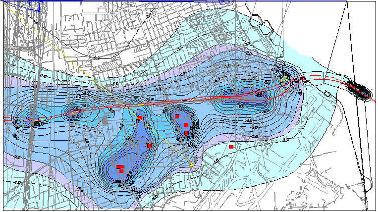 Figure 3 Øresund Land Works, Amager.
Groundwater table, metres, October 1996
Figure 3 Øresund Land Works, Amager.
Groundwater table, metres, October 1996
4. PROJECT DESIGN
As an example of the project design process, the discharge results from the 3-D simulations of two different alignments for the Øresund link are shown in table 1.
Location Alternative 1
(1000 m3/year)Alternative 2
(1000 m3/year)Reduct. (%) Copenhagen
Construction phase320 220 30 Amager West
Construction phase1900
1600
20
Copenhagen
Operational phase700
440
35
Amager West
Operational phase1650
1350
20
Table 1. Calculated discharges for two alternative alignments
The groundwater lowerings caused by the temporarily and permanently dewatering for different vertical alignments have been evaluated by use of the 3-D groundwater models. Furthermore, the amount of temporary and permanent discharged groundwater has been calculated by use of the models.
The detailed and improved design has resulted in the following general instructions to the contractors:
- the ground water lowering shall be kept to a minimum of what is necessary according to constructions
- discharge of ground water must not result in contamination of sea, lakes and ponds, streams or groundwater
In order to meet these objectives, each contractor is to prepare an action plan before commencing work, describing the handling of groundwater lowering including methods of lowering and way of discharge.
5. PROJECT CONSTRUCTION
The main purpose of the groundwater management program in the construction phase has been to ensure that legal requirements could be fulfilled.
As a tool for the groundwater management and for general control of soil conditions and relations/ reporting to the municipalities, the contractors have been contractly instructed to record all borehole data in a standard digital form and to report the resulting data monthly to the central geo database.
All information has been implemented in the geo database. This procedure has made the following possible in the construction phase;
- to make a running revision of the geology and groundwater situation available for the contractors on request
- to compare and revise the hydrogeological model for more accurate 3-D groundwater modelling if necessary
- to analyze changes in the hydraulic head at critical spots
- reporting of environmental soil and groundwater problems
On the basis of the dewatering time schedules from each contractor, prognoses of the groundwater situation have been made continuously throughout the construction period.
Furthermore, the model made it possible to forecast the discharge per hour through the entire construction period. This has been especially useful controlling the total nitrogen outlet to the harbour.
On basis of the above described simulations a "groundwater budget" for each contract was introduced, in order to control the amount of discharged water. The introduction of this budget has contributed to a greater consciousness about the environmental problems by dewatering and in general optimum dewaterings have been achieved.
6. DISCHARGE WATER
The discharge water from groundwater lowering at the infrastructure projects will, if possible, be reused. If the quality of the water is acceptable it may be used in the public water supply after normal treatment. The water quality is, however, normally not adequate to drinking water so neighbouring industry with a high water consumption is evaluated as possible purchasers if the quality demands can be met.
For both the Øresund Link and Copenhagen Airport a system to collect and distribute nearly all the discharge water has been established. About 1 - 1.5 mio. m3/year from The Øresund Link are reused in the district heating system and replace an earlier use of about the same amount of drinking water. At the Airport discharge water will also be reused in the cooling system before it is led to the district heating plant.
7. CONCLUSION
Groundwater management has become a more and more essential part of large urban infrastructure projects.
Numerical 3-D groundwater models have been used for many years, but the introduction of the models as a general groundwater management tool in the design phase as well in the construction phase has proved to be useful for general handling of environmental problems.
Furthermore, the experiences from the infrastructure projects in Copenhagen have revealed that a groundwater model based upon a very detailed study of the geology is a must in order to obtain the necessary agreement between simulated and observed phenomena and to obtain the right geotechnical design- and construction basis.
Name: Hans-Martin Friis Møller
Title: Geohydrologist
Company: Rambøll
Address: Bredevej 2
Zip code: DK-2830
Phone: +45 45 98 60 00
Fax: +45 45 98 69 34
E-mail: hmm@ramboll.dkName: Lars Møller Marksussen
Title: Hydrogeologist, Chief Adviser
Company: Rambøll
Address: Bredevej 2
Zip code: DK-2830
Phone: +45 45 98 60 00
Fax: +45 45 98 69 34
E-mail: lmm@ramboll.dk