![]()
by: Rasmus Steenberg Andersen:
Cartography
by: Rasmus Steenberg Andersen:
In this paper the experiences made by GEOvision changing from the AutoCAD and Adobe Illustrator to ArcInfo and Cartographic Production System in mapping production is described. The focus is especially on the demands the new technology makes on the company and its staff. Lastly the wishes to future releases of ArcInfo is expressed seen from the point of view of a cartographic company.
In 1992 Kortgruppen a/s set itself the goal to become the leading supplier of cartographical beautiful maps and geodata to be used in route optimization and business analyses in Denmark. Since 1986 Kortgruppen has supplied the danish municipalities with maps of high cartographic quality. In 1989 Kortgruppen became soul supplier of maps to the telephone directories of the Danish national telephone company Tele Danmark, and as a consequence Kortgruppen today has a national graphic "database" containing:
- Points of interest including names
- Road centerlines including names
- Stream centerlines including names
- Railroads
- Ferries - domestic and foreign - including destinations and sail time
- Land use - cities, see/lakes, forests/parks, cemeteries, summer house areas and squares - including names
- Buildings - public and major buildings, sport centres - including names
At the present time Kortgruppen has digital maps in scale 1:200.000 and 1:500.000 that covers the whole of Denmark together with an extensive city map database containing approximately 800 cities and approximately 200 summer house areas - and more is to come.
The use of georelational data in route optimization and business analyses has risen significantly through the 1990's. Taking the increasing use of geodata into consideration, it was a natural step forward to extend the present range of products to include georelational data. As a result of the close cooperation with Tele Danmark the interest of combining data from the White Pages and the Yellow Pages with map data grew more and more interesting. Hence Kortgruppen and Tele Danmark initiated a joint project with the intend to analyse the use of georelational data in route optimization and business analyses, subsequently analysing what changes had to be made to the production of the geometrical data. The interim result of the joint project is the founding of the joint enterprise GEOvision on January 1st 1997. GEOvision's primary goal is to be Denmark's leading company in the field of cartography and GIS.
Since 1989 Kortgruppen has produced maps digitally. The geometry is produced and maintained in AutoCAD. Here every theme has its own layer. When producing a graphical map an AutoCAD DWG file is converted into a DXF file which again is converted into an Adobe Illustrator file. During conversion every element is given printing information and a place in the Illustrator layer hierarchy through the use of standard conversion tables. In Illustrator the graphical expression can be manipulated such as polygon fill, stipples and color handling using CMYK or PANTONE.
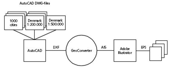
Figure 1 Production process for maps in telephone directories using AutoCAD and Adobe Illustrator. From the existing AutoCAD files a clip is made and exported to DXF. Then the especially developed GeoConverter converts the DXF to Adobe Illustrator. In Adobe Illustrator the files are checked before an export to EPS is made and shipped to Tele Danmark.
When extending the product range into the GIS field a change of the production process is required. CAD programs can not handle the topological relations necessary to make data analyses. The superior demand to a new production platform was simple:
Kortgruppen has to be able to deliver all existing products along with topologically structured data to be used in route optimization and business analyses.
It was a top priority demand that the production of GIS data and the production of graphical data could be parallel until the final product was to be made in order to save time and money. Other demands were:
- Tools for producing geometrical data in relation to a specific coordinate system (CAD functionality)
- Tools for topology and attribute handling (GIS functionality)
- Many import- and export filters to be able to get data from many sources as well as satisfy data buyers
- Tools for raster handling (on-screen digitizing)
- Support for CMYK and PANTONE colors
- Tool for generating street indexes
- Macro language for automating routine tasks
- Network based
ArcInfo and Cartographics Production System from T-kartor in Sweden was chosen as new production platform. The most weighty arguments were:
In the future production process the maintenance of the MDB and PDB's will be the core function. From these databases the graphical products and GIS products is to be derived.
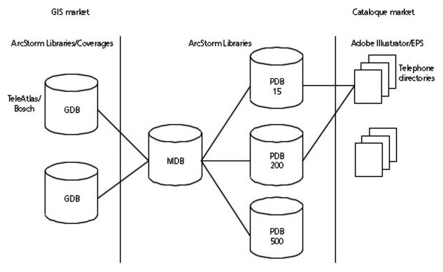
Figure 2 Producing telephone directory maps and GIS data with ArcInfo and CPS. From the MDB or PDB the necessary data is copied. In CPS the map pages is being set up and an export to Illustrator is being performed.
The change from AutoCAD and Illustrator to ArcInfo and CPS has not yet proved to be more rational when producing telephone directory maps. This is primarily due to the fact that:
- Data has to be converted from AutoCAD to ArcInfo, coded and loaded into the MDB
- Data has to be transferred to the PDB in scale 1:15.000 where the cartographical work is performed
- The map pages has to be set up from scratch in CPS
- Data has to be clipped out from the PDB and adapted to the pages
Henceforward this process will be less time consuming. Firstly the data conversion process has already been performed and secondly the updating of MDB and PDB will be done as a separate task - of course taking graphical production into consideration. The only process related directly to the production of map pages is clipping out data from the PDB and adapting them to the pages.
It is relatively easy to list the demands to a new production system. It is not easy to anticipate the demands a new production system makes to the company and its staff. Selecting ArcInfo all data had to be re-organized into coverages with corresponding attributes unlike AutoCAD where all data can be contained in one single file. The database design has been an iterative process. The current version number of the database is 4.0.
The change from a layer way of thinking in CAD to a topologically way of thinking has been a tough switch over. A crucial question has been: Are we to train our present staff or are we to hire new staff - or a combination? It has been GEOvision's experience that it is hard to find GIS people with an adequate cartographical knowledge to be able also to produce graphical products without an extensive training. Hence GEOvision has initiated an extensive internal and external training of its staff of 10.
The production of GIS data - and the use of them - has made the need for staff with GIS training very clear. The training of non-GIS staff is not to be underestimated. It is quite time consuming, but is absolutely necessary to ensure a consistent database and independent production. Likewise the difficulties in maintaining a graphical production, initiating a GIS data production and at the same time educating old and new employees must not be underestimated.
The working methods from the graphical production on AutoCAD can not be transferred to the production of GIS data. Unlike graphical data, which are geometry with some printing information structured in a vertical layer structure, GIS data is topologically related objects having georelational properties. For example, a road centerline is no longer just a linestring having a width and colour, but is now part of a network. The road segment now has a class, a name, an adress interval etc. This takes getting used to and it is hard to let go of old habits and old ways of thinking.
A need for automating routine tasks and programming production enhancing macros quickly arised. It takes programming skills and experience with the ArcInfo software to develop macros. The development of routines spreads quickly and should be structured from day one. The routines should be documented and collected in a toolbox - especially if there is more than one programmer.
Equally important as defining your data dictionary for the MDB (what is to be registered) it is to define your demands to the quality (how accurate and how complete). Especially is to be taken into consideration if you are producing high quality data for the customer or for yourself. GEOvision operates with two standards: A and B. The difference between the two standards is the number of themes and attributes being registered. In addition to the two standards are four geometric accuracy classes.
Knowledge has to be spread. Individuals with special knowledge are likely to become bottlenecks in the production. On the other hand, co-workers must desire to acquire this knowledge and make their own experiences using the try-and-error technique.
Has GEOvision reached its goals and fullfilled its expectations? Not yet! The final version of MDB and PDB's are yet to be found - but we are very close. The final version number is expected to 4.1 or 4.2. The definition of the ArcStorm layers were final in version 2.0. The following versions reflect the development in the number of themes using routes and regions and the number of attributes being registered.
The graphical database has not yet been converted. GEOvision has estimated that the conversion process will take 7000 hours. This estimate is not likely to hold. This is due to the fact that all conversion is being done on a need-to-convert basis - i.e. when a job demands the data to be converted - and not as a continous process. Another factor is the shortage of the "right" staff. People with GIS training - or desire to learn GIS - is almost impossible to find. Furthermore the current staff still needs to be completely familiar with the new production processes. Taking the staff members educational background and work experience into consideration an ArcInfo introductional period of 3 to 6 months has to be expected. Furthermore a period of 3 to 6 months to develop a high degree of confidence with the new production process must be anticipated.
Only map pages in the scale of 1:15.000 has been produced using ArcInfo and CPS - no maps in scale 1:200.000 has been produced. GEOvision does not expect this to be crucial for completing the database design, but the production of a PDB in the scale 1:200.000 requires considerable generalizations. These generalization routines still needs to be developed.
The ArcInfo and CPS production process still needs to be proven less time consuming as the AutoCAD/Illustrator process. There are no doubt in our minds, though, that when already delivered map pages to telephone directories are to be updated, a considerable time-saving will be experienced.
GEOvision has not regretted the choice of ArcInfo and CPS as new production platform. Even though the expected time-savings for map page production still has to be seen, ArcInfo has shown to be a very effective GIS toolbox. But seen from a cartographical point of view, the tools still are insufficient.
First and foremost ArcInfo should be able to support Illustrator version 5 with layers instead of the (very) obsolete version 2 (also known as version 88). The graphical business has for many years been able to work with layers, and it is signalling low-quality products not to be able to support Illustrator with layers. Talking postscript, a better EPS export must be supported. It is not satisfactory that an ArcInfo EPS file can not be previewed in Desktop Publishing programmes such as Illustrator, PageMaker and QUARK. It must be a minimum demand, that the EPS file contains an imageheader.
Tools for map generalization is lacking. GEOvision would especially welcome tools for stream and coastline generalization, building generalization and merging of a clung of non-adjacent polygon of same class. Consequently it was a pleasure to learn from the San Diego user conference this summer, that cartography will be given a higher priority. ArcInfo 8.0 will contain some strong generalization tools - and judging from a sneak preview, they seem to be right. Still version 8.0 is not due for a year or so, so we are in for a long wait.
ArcInfo text handling is pretty good, but text masking only "breaking" underlying objects with the same color as the text will be highly appreciated.
GEOvision is on the way to reach its superior demand on rationalizing the current map production and extending the product range to GIS data. At the present GEOvision has been delivering solutions and products to:
- Bosch and TeleAtlas, Germany. Street network for the counties of Copenhagen, Roskilde and Fredensborg and major road network for the rest of Denmark. The data is to be used in the navigational system Bosch TravelPilot.
- Navigation Technologies (former EGT), Belgium. The Danish major road network. The data is to be used for navigation.
- ·MD Foods, the largest dairy in Denmark. Geocode all dairy cattle farms in Denmark. The Danish interconnecting network for route optimization between dairy farms and dairy.
- Municipality of Aalborg, Denmark. Producing graphic maps ranging in scales from 1:10.000 to 1:160.000 from technical data.
- Tele Danmark, Denmark. Bringing the Yellow Pages and maps to the internet.
"It is difficult to foretell - especially about the future", a danish philosopher once said, but we at GEOvision has no doubt that the future will bring an exciting and busy future in the field of GIS.
Rasmus Steenberg Andersen
GIS System Manager
GEOvision a/s
Danmarksgade 81
DK-9900 Frederikshavn
Denmark
Phone: (+45) 98 43 43 06
Fax: (+45) 98 43 28 17
E-mail: rsa@geovision.dk