Abstract: This presentation will discuss Design Power's GIS implementation on behalf of the Navy Public Works Center (Yokosuka, Japan), and the Naval Communication and Telephone Station, Far East. It will cover the initial conversion of legacy hardcopy distribution and schematic documents into intelligent electronic formats, from which users can dynamically extract and display cable routing information. The enterprise nature of PWC Yokosuka’s total GIS implementation permits telecom users to concentrate on maintaining their own data and yet concurrently display data maintained by other facilities management departments (utilities, planning, environmental, etc).
The
mission of PWC Yokosuka is to provide responsive, reliable, high quality and
cost-effective public works, public utilities, transportation support,
engineering services, shore facilities planning support, and all other logistics
support of a public works nature required by the operating forces, shore
establishment and other Navy customers within the Kanto Plain of the nation of
Japan. In an effort to improve
these services, PWC initiated a central program in 1996 to begin implementing
Geographical Information System (GIS) technology throughout the Command.
The
Japanese islands of Honshu and Kyushu are home to numerous United States
military installations belonging to all the DOD services. In 1998, PWC Yokosuka
began providing GIS implementation services to various U.S. Military Commands in
Japan and now serves as the Regional coordinator for Navy GIS implementations
Japan-wide, excluding Okinawa.
PWC
Yokosuka’s GIS management function rests within the Engineering Department.
The GIS staff consists of one U.S. Civil Service employee and three
Japanese national employees. The
PWC Information Systems group is responsible for system procurement,
configuration and end-user support for issues not related to using GIS software.
Data maintenance is distributed among functional users of various
departments who work with the data on a daily basis. This frees the GIS staff to focus on the implementation of
the technology and resolving various data-related issues that arise.
Shared
Data Model
The nature of the public works facilities management operation requires that we accommodate diverse requirements into a common system. At the core of PWC Yokosuka’s GIS implementation philosophy is the shared data model. This model places the land base, or “existing conditions map” at the center. Our first priority for each installation is to develop a digital map that satisfies the following:
“Up-to-date”
– The map should be no more than two years old.
Old data is the biggest enemy to a successful implementation.
“Spatially
accurate” – Overlay of survey-quality data onto the map is possible with
reasonable results. For us, that
means accuracy within plus or minus ½ meter.
“Geo-referenced”
– The map is in a valid projection and coordinate system.
This facilitates the addition of new data and maintenance of existing
data.
“Topologically
Correct” – The features that make up the map are drawn in a way that
permits the GIS to recognize and use them properly.
For example, buildings must be drawn as a closed polygonal boundary where
all corners match exactly. Topology
is the biggest barrier to using legacy CAD data in GIS.
“Spatially
contiguous” – To the fullest extent possible, it is important for the
land base to be seamless. All
adjacent areas should be together in a single coverage.
In the “old” days, areas were split up to keep file size at a
minimum.
“SDS
compliant” – Features should be named, broken out and/or aggregated in
accordance with the latest release of the CADD/GIS Spatial Data Standards.
The PWC Real Estate group is responsible for making regular updates to the digital existing conditions data. Other functional groups (utilities, planning, telecomm, etc.) then use this map as the foundation of their respective interface to the system. For example, the utilities department overlays their water, steam, etc. distribution systems onto the Real Estate Base map. The utilities department staff is then responsible only for the updates to their subset of data. The maintenance processes are set in conjunction with their existing work procedures. A new base map appears to them every three or four months when Real Estate publishes an update.
By sharing a common foundation, separate functional groups are able to share and make use of each other’s data. For example, the Planning group is able to display utilities information as they make decisions concerning the future development of the base. By leveraging our data in this manner, the value of the system increases exponentially.
To
facilitate the sharing of technology solutions across installations and between
agencies, aspects of portability must be considered as a part of the
implementation.
At
PWC Yokosuka, the basic functionality revolves around the base map, real estate
information, and photos and floor plans of the facilities.
All application coding is contained within program units (termed ArcView
extensions) that can be loaded and unloaded from the core project files.
Data
sets that are not a part of the base map can be loaded in two ways.
Casual users who need to view the data, can load “data groups” as
additional overlays. Advanced users who need to analyze the data can load an
ArcView extension, which in turn will load the data and provide the user with
additional functions necessary to run the application.
Variables are used in all of applications in lieu of hard-coded drive paths. Thus, users with different drive mappings (or using different machines) are able to customize the variables to suit their particular setup. The concept of applying variables in lieu of drive mappings is an essential one.
By building portability into the system design, it is easier to accommodate the change and growth of the system over time.
At the time this project was awarded to Design Power by Navy PWC Yokosuka, all telecomm records were maintained by the Naval Communication and Telephone Station, Far East (NCTSFE) in hardcopy form. However, the goal of the agency was to use migrate to CAD and GIS technology to better automate their processes.
The following primary types of documents were maintained by NCTSFE:
a) Duct distribution drawings (shows simple routing of ducts between manholes). These were the simplest to represent digitally and the information did not change frequently.
b) Cable distribution drawings (shows routing of cables between manholes). These drawings showed “bands” of cables overlaid onto the base map. These drawings were complex and were used as a “bridge” between the duct distribution and the schematics.
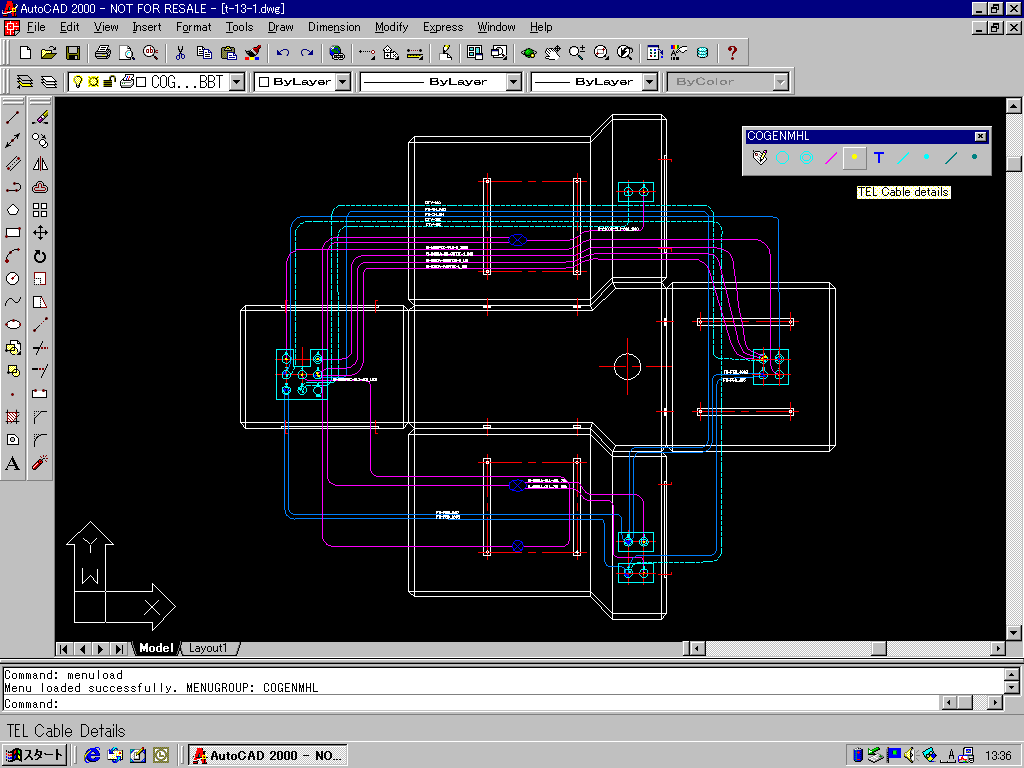
c) Manhole and handhole schematics (also termed “butterfly” schematics). This is where the details of the conduit and cable routing were documented. These documents are also very complex.
After an assessment of the NCTSFE operation, the decision was made to pursue an implementation that used the duct distribution and schematic data as its data sources. The cable routing could then be derived as a by-product of the integration of this information.
The first step was to take the existing duct distribution drawings and digitize them. This was done using CAD software with scanned images of the original 29 drawings as a backdrop. Specific procedures were followed to ensure that the final data set was geo-referenced and topologically correct. The GIS base map was used as a backdrop for correcting digitized locations per the shared data model. Unique identifiers were assigned to all features (ducts, manholes, handholes, etc.) to support the subsequent tracking of cable routing information.
Surveyed location data for telecomm features is also being used to further improve the spatial accuracy of the telecomm distribution data set. For additional information on this specific procedure, please refer to the Esri UC99 Paper entitled “Utility System Management: Migration from CAD to GIS” by Mr. Ayman El-Swaify.
Once the Yokosuka base telecomm duct distribution drawing was in place, attention was focused on creating intelligent schematic drawings for both manholes and handholes.
The ultimate goal for these schematics was that NCTSFE staff could create and maintain them over time. Because the technicians were already familiar with the layout of these documents, we felt that this was the best way to give them an interface to the system. Therefore, we decided to create templates for all standard types and use these as the basis for creating schematics with specific routing information for all manholes and handholes.
The schematics are designed to capture conduit and cable information in such a manner that it can subsequently be extracted into an external tabular data file.
The process of converting schematic information into digital form makes up the biggest portion of the effort, since there are over 700 schematics for the Yokosuka base.
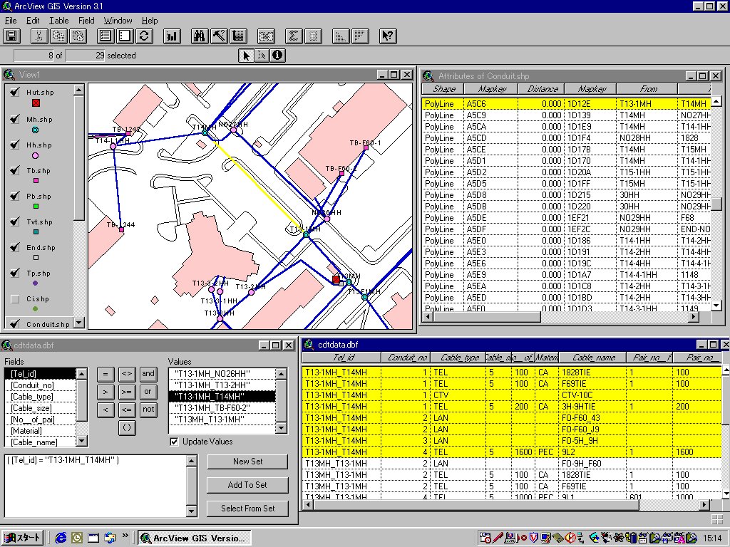
Once the schematics are complete, the next goal will be to extract the routing information into a database. This tabular data will be joined to the duct distribution to permit cable tracing and identification of spares.
The
telecom design approach used by Design Power and Navy PWC Yokosuka focuses on a
database-centered solution to tracking telecom conduit and cable routing.
Using the butterfly schematic as an end-user interface, the necessary
data is captured, extracted and joined it to the GIS duct distribution map.
Then telecom managers can use the GIS to perform cable tracing and
identify spares.
|
Yoshikuni
Hirayama PresidentDesign Power Corporation & Guide-Map.com,
Inc. Frontier
Bldg. 3F, 1-2-20 Nakamachidai Tsuzuki-ku,
Yokohama 224-0041 JAPAN 011-81-045-945-1224 FAX
011-81-045-945-1223 |
Ayman
S.A. El-Swaify CADD/GIS ManagerNavy
PWC Yokosuka, Code 400C PSC
473 Box 13 FPO
AP 96349-1103 011-81-311-34-7986 elswaifya@pwcyoko.navy.mil |