This paper describes a GIS process used to develop the New Zealand Landscape Classification (NZLC). The classification provides a frame of reference for communication and an inventory of scenery. The classification does not provide information on quality but provides information on character, such as landform, vegetation, naturalness, and water. It is hoped that researchers will use this classification to link landscape character with the public’s perception of quality. GIS is an ideal platform for the development of a landscape classification because it provides an explicit framework that enables criteria to be questioned and the classification to evolve with improved understanding.
Introduction
Landscape in this paper is defined as the "appearance of the land" (Swaffield 1991), or the "environment perceived" (Appleton 1980) or the "spectacle presented by the countryside" (Countryside Commission 1970). In most countries, landscape contributes considerably to people’s quality of life and is a major part of the tourism industry in many cases. In New Zealand, for example, the landscape is a multibillion dollar tourism resource that has considerable quality of life value for ordinary New Zealanders. Given the importance of landscape, it is not surprising that any human-induced change to the landscape, such as the construction of hotels, infrastructure or plantation forestry, can be very controversial. This is particularly the case in wilderness areas and planners face the dilemma of how to provide facilities for tourists without compromising the landscapes that the tourists have come to see.
When considering the landscape impacts of a particular development, planners need information on the compromises that are being made to landscape quality. Landscape quality depends on whose perceptions are being considered – beauty is in the eyes of the beholder (Dearden 1989). Landscape researchers need a methodology for obtaining landscape quality information that can be validated by independent researchers and applied to a number of locations. One such approach is known as psychophysical analysis.
The psychophysical approach is based on the work of classical psychophysics, which sought to establish quantitative relationships between physical features of environmental stimuli and human perceptual responses (Daniel and Vining 1983). Landscape quality is determined by the public, not by experts. This approach typically involves two stages. The first is the classification of the landscape into reasonable homogeneous classes, which are usually based on aspects of landform, landcover, naturalness and water. The second stage is the evaluation of quality of the different classes within the classification. This is done with a public preference survey, with the classification acting as a frame of reference. With public preference surveys, typically, samples of the public are questioned about how they rank each landscape class for its visual quality. The survey could require a sample of the public to visit landscape sites, but usually photographs of the classes are used, and these are ranked. The psychophysical approach might identify a consensus within society, but it could also show that different groups in society value landscapes differently.
The psychophysical approach requires a landscape character classification as a frame of reference for the research. To manage and research landscapes effectively, it is essential that landscapes are classified so that planners have an inventory and a frame of reference for communication and research. Many of the major sciences use classifications because they enable researchers to communicate effectively and precisely and, therefore, to compare results and develop a consensus of knowledge. For example, consider the benefits of plant classification for botanists. Despite this, landscape researchers do not have a well-established landscape classification and, as a result, their research cannot be effectively communicated and compared. Consequently, a consensus of understanding on landscapes has been slow to develop. It is critical that a landscape classification be developed so that landscape research can advance our understanding of the nature of landscapes and ascertain the values associated with different landscapes. A landscape classification can be used for monitoring landscape change, calculating uniqueness and determining variety. Although landscape evaluation is an important end use for a landscape character classification, evaluation or the assessment of landscape quality will not be directly considered in this paper. A landscape character classification does not identify quality, but because it is used for evaluation, it must differentiate classes that are different in perceived quality.
This paper describes a landscape classification developed for New Zealand. It also examines some applications of the classification.
Classification Criteria
To develop a useful landscape classification, it is necessary to have a set of criteria. Two sets of criteria are used here: a general set of classification criteria that is common to all land-based classifications, and a set of specific criteria developed for landscape classification.
General Criteria
The general criteria were adapted from Rhind and Hudson (1980), who used them as criteria for a landuse classification. These are as follows:
(b) It must be easily understood and applied.
(c) It has to produce repeatable results that are independent of the researcher.
(d) It has to be hierarchical to cope with needs at different levels of resolution in different areas. It must to be sufficiently flexible for new interests and tasks to be met from a modified, rather than a completely new classification.
Specific Criteria
For a classification to be useful for science, it must have a specific purpose and be based on theory relating to that purpose (Haines-Young and Petch, 1986). As previously mentioned, a landscape character classification is used for subsequent evaluation research. A landscape classification for this purpose must therefore distinguish characteristics that affect quality. So what is the theory on the characteristics that affect quality? The specific criteria that a classification should follow are listed below; they are designed to capture important landscape characteristics that affect quality. A discussion on the theory behind these criteria follows.
2). The classes should be based on the general public's perception of the above attributes.
3). The classes should be based on an overall impression of the above attributes from a distance and involve generalisation and combination.
4). The classes should recognise that landscapes surround and are experienced
from a multiple of geometrical perspectives that can be obtained from movement
and exploration.
The landscape attributes have been identified from content category research. The Countryside Commission (1988) summarised this research, and the above attributes comply with it, as well as with other research (Amedeo, Pitt and Zube 1989). A problem with content category research is that it is specific to particular locations. However, the above attributes have been used by landscape researchers worldwide, and common language used to describe landscapes often relate to these attributes. In this paper, landscape attributes refer to landform, vegetation, naturalness or water, while landscape components refer to objects that are part of these attributes (mountains, forest, lakes, cities).
Criterion 2
The landscape is derived from an interaction between aspects of the environment (landscape components), and human perception processes. Landscape perception depends not only on these physical landscape components, which may be extremely diverse, interrelated and complex, but also on the values, past experience and social-cultural conditioning of the observers (Dearden 1989). Jones (1991) describes this complexity as the "elusive reality of landscape". He adds that, in the past, the lack of recognition that landscapes are a physical reality and a social or cultural construct has led to an "academic battlefield", with different disciplines and schools concentrating on either the physical landscapes or on the observer. It is necessary for a landscape classification to be based on a particular type of observer. Since it is the evaluation of the public's perception of landscape quality that is important to planners, the public's perception of landscape character should be considered in a landscape classification, rather than the perceptions of specialised scientists (Zube, 1984).
The difficult questions that arise are, what is the public, and what
is the nature of its perception? The notion of a general public eliminates
extreme perceptions, yet the general public is not a homogeneous group.
A classification should be based on the lowest common denominator within
this group. For example, not all people perceive the difference between
exotic and indigenous vegetation, but many members of the public do; therefore,
the distinction between exotic and indigenous vegetation is necessary.
This lowest common dominator level is not always obvious, and a classification
should be hierarchical (a general criterion that has been specified) to
cope with a range of different perceptions.
Criterion 3
People’s landscape impressions cannot possibly contain all the information that exists in reality (Zube, Sell and Taylor 1982). The landscape is therefore a generalisation of reality. The notion that landscapes are an impression from a distance gives an indication of this generalisation. Landscape does not include small objects, such as snails, frogs and forest understory.
Landscapes cannot be simply classified by dividing the land into areas
that reflect boundaries between different landscape attributes, such as
landform and vegetation, because it is these boundaries that are important
characteristics of landscapes (Jackson 1984). The interaction of components
is sometimes more important than the components themselves (Arthur, Daniel
and Boster 1977). A landscape classification, therefore, needs to incorporate
this juxtaposition of boundaries between different components of the landscape
in order for the classification to distinguish landscape quality. This
consideration makes landscape classification particularly difficult, but
if it is not included, the classification will not be useful for evaluation
research. In one respect, landscape is a generalisation of the environment,
because it includes only the large visual entities. However, when combinations
of these generalised entities are considered, an unlimited number of different
combinations become apparent.
Criterion 4
The last specific criterion (taken from Zube, Sell and Taylor 1982) suggests that from a point a landscape does not just include components that can be directly seen from that point, but also incorporates components that may have been viewed during exploration of the neighbouring region.
Other Possible Criteria
There are many aspects of the landscape that vary considerably, such as the weather, polluted air and the sun. It is not necessary to include these in a classification because they are often held constant in landscape research when different landscapes are compared.
The list of specific criteria may appear oversimplified considering the complex nature of landscapes. Many questions are left unanswered- what is the exact nature of the landscape components and their relationship with each other, and what is the exact nature of the observer? If more specific criteria were stated, their validity would be questionable because of the lack of landscape theory - "theoretical vacuum" (Appleton, 1975). More research is required. However, a landscape classification is needed so that researchers can communicate their results. The dilemma is that it is necessary to understand the nature of landscapes to classify. Yet, to understand the nature of landscapes, it is necessary to classify. A classification must be developed with the information available and reassessed as more information becomes available. It is in this way that classifications evolve. Currently, our understanding of landscapes is superficial and needs to be based on many assumptions.
Despite these oversimplified specific criteria, if a classification can meet all of them and the general criteria, a significant advancement has been made. To date, this has not been done successfully with manual processes. Complex definitions that incorporate the important characteristics of landscapes have been too tedious and costly to implement manually. Instead, intuition has been used to decide the appropriate classes for different areas. This has not been repeatable and does not provide a frame of reference for different researchers, which in effect makes the classification of little value for science. When manual classifications have used explicit definitions, these have often been simple so that they can be easily implemented. The result is that the classification does not incorporate the important characteristics of landscapes.
The Landscape Classification Process
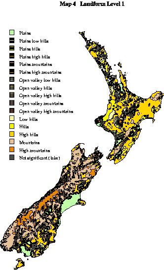
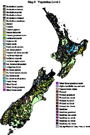
The landscape classification was developed using a Geographical Information System (GIS) and national topographic databases. The classification is based on the notion that the landscape character of an area can be determined from a range of hard-copy topographical maps. It is possible to identify what the landforms of an area are like using contour information. It is also possible to determine whether an area is developed and contains lots of roads, buildings and utilities. A map will also show whether an area is by a lake, river or the coast. It is also possible to consult more specialised maps such as vegetation and population maps, and these will influence the type of landscape perceived for an area. A good map-reader can develop an accurate impression of what the landscape will be like without visiting the site. Many of the latest topographical maps now exist as digital layers within a GIS, and it is possible to use GIS to automatically analyse these digital maps.
An important function within GIS that enables landscapes to be identified from topographical data sets is the focal neighbourhood function (Tomlin, 1990). A GIS can represent topographical data sets in a raster data model, whereby an area is divided into square cells and each cell is assigned a number that reflects the presents of a topographical feature. With a focal neighbourhood function, each cell within the specified coverage becomes, in turn, the center for processing. When a cell is being processed, the cell values within the specified neighbourhood of that central cell are included in the processing. The result of this processing is then assigned to the cell of a new grid coverage with the same position as the central cell, and the next cell in the first grid coverage becomes the center of the processing. This continues for all the cells available for processing. The neighbourhood can be of any shape, which can be directly specified in some GIS software or can be custom designed. Focal functions are particularly powerful for landscape classification. In effect, they assess the land from thousands of different points and can be used to capture the characteristics of the surrounding location of each point. For this reason, it is more suitable for landscape classification than the conventional areal analysis units. The spatial influence of many different landscape components can be assessed, and this can be used to identify landscape combinations. Duffield and Coppock (1975) used a focal function for identifying recreational landscapes - a commendable effort considering this was pre-commercial GIS.
The classification process analyzes New Zealand from about one million
different points. From each point, it calculates the influence of a large
range of different landscape components (different vegetation types, landforms,
infrastructure and water components) in the surrounding area (3,000 m radius),
with spatial distributions obtained from national topographical databases.
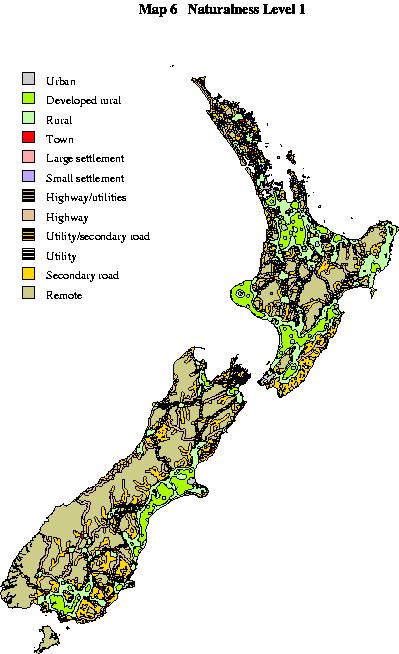
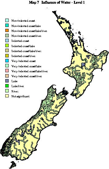
Using this influence information, landscape classes are defined. The classification
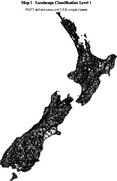
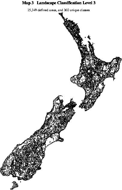
also has three levels of generalisation. For level one, 7,461 classes are
identified and a polygon outline of this is shown in map
1. Map 2 and Map 3
show the polygon outlines of level 2 and 3, which have 1,732 and 339 classes
respectively. The classification is constructed from the unique combination
of landform, vegetation, naturalness, and influence of water, thesefore,
the best way to comprehend the information available in this digital classification
is to view the landform map, vegetation
map, naturalness map, and water
map separately. All the information seen in these maps is available
in the digital classification. Tables 1, 2, 3 and 4 below show the classes
included, as well as how the different levels of generalisation were derived.
|
|
|
|
| Plains (1) | Plains (1) | Plains (1) |
| Plains Low Hills (2) | Plains Hills (3) | Hills (13) |
| Plains Hills (3) | ||
| Plains High Hills (4) | ||
| Low Hills (12) | Hills (13) | |
| Hills (13) | ||
| High Hills (14) | ||
| Open Valley Low Hills (7) | ||
| Open Valley | ||
| Hills (8) | ||
| Open Valley Hills (8) | ||
| Open Valley High Hills (9) | ||
| Mountains (15) | Mountains (15) | Mountains (15) |
| High Mountains (16) | ||
| Open Valley Mountains (10) | Open Valley Mountains (10) | |
| Open Valley High Mountains (11) | ||
| Plains Mountains (5) | Plains Mountains (5) | |
| Plains High Mountains (6) | ||
| Not significant (23) | Not sig. (23) | Not sig. (23) |
| LEVEL 1 46 Classes | LEVEL 2 14 Classes | LEVEL 3 10 Classes |
| Horticulture pasture (1) | Horticulture (1) | Horticulture (1) |
| Horticulture tussock (2) | ||
| Horticulture scrub (3) | ||
| Horticulture forest (4) | ||
| Horticulture wetland (5) | ||
| Horticulture sanddune (6) | ||
| Pasture (7) | Pasture (7) | Grassland (7) |
| Tussock (8) | Tussock (8) | |
| Tussock pasture (9) | Tussock past. (9) | |
| Pasture ind.scrub (10) | Grassland scrub (12) | Scrub (13) |
| Tussock grassland scrub (12) | ||
| Lowland ind.scrub (13) | Indigenous scrub (13) | |
| Alpine scrub (15) | ||
| Exotic scrub (14) | Exotic scrub (14) | |
| Exotic scrub pasture (11) | ||
| Ind.forest pasture (16) | Indigenous forest (26) | Indigenous forest (26) |
| Ind.forest tussock (scrub) (18) | ||
| Ind.forest ind.scrub (20) | ||
| Ind.forest ex.scrub (21) | ||
| Ind.forest alpine scrub (22) | ||
| Ind.forest scrub pasture (24) | ||
| Indigenous forest (26) | ||
| Ex.forest pasture (17) | Exotic forest (27) | Exotic forest (27) |
| Ex.forest tussock (19) | ||
| Ex.forest scrub (23) | ||
| Ex.forest scrub pasture (25) | ||
| Exotic forest (27) | ||
| Mixed forest (30) | Mixed forest (30) | Mixed forest (30) |
| Mixed forest grassland (31) | ||
| Mixed forest scrub (32) | ||
| Mixed forest grass scrub (33) | ||
| Alpine (herb fields, rock, & ice) (29) | Alpine (28) | Alpine (28) |
| Tussock alpine scrub (28) | ||
| Wetland (34) | Wetland (34) | Wetland (34) |
| Wetland grassland (35) | ||
| Wetland Ind.scrub (36) | ||
| Wetland Ex.scrub (37) | ||
| Wetland Ex.forest (38) | ||
| Wetland Ind.forest (39) | ||
| Sanddune (40) | Sanddune (40) | Sanddune (40) |
| Sanddune grassland (41) | ||
| Sanddune Ind.scrub (42) | ||
| Sanddune Ex.scrub (43) | ||
| Sanddune Ex.forest (44) | ||
| Sand dune Ind.forest (45) | ||
| Not significant (Urban, river, or lake) (46) | Not sig. (46) | Not sig. (46) |
|
|
|
|
| Urban (1) | Urban (1) | Urban (1) |
| Developed rural (2) | Rural (2) | Rural (2) |
| Rural (3) | ||
| Town (4) | ||
| Large settlement (5) | Large settlement (5) | Settlement (5) |
| Small settlement (6) | Small settlement (6) | |
| Highway utility (7) | Highway (9) | Highway utility (7) |
| Highway (9) | ||
| Utility secondary road (10) | Utility (13) | |
| Utility (13) | ||
| Secondary road (17) | Secondary road (17) | Secondary road (17) |
| Remote (22) | Remote (22) | Remote (22) |
|
|
|
|
| Non-indented coast (13) | Non-indented coast (13) | Coastal (13) |
| Non-indented coast lake (6) | ||
| Non-indented coast lake river (3) | ||
| Non-indented coast river (10) | ||
| Indented coast (14) | Indented coast (14) | |
| Indented coast lake (7) | ||
| Indented coast lake river (4) | ||
| Indented coast river (11) | ||
| Very indented coast (15) | Very indented coast (15) | |
| Very indented coast lake (8) | ||
| Very indented coast lake river (5) | ||
| Very indented coast river (12) | ||
| Lake (1) | Lake (1) | Lake (1) |
| Lake river (2) | ||
| River (9) | River (9) | Not significant (16) |
| Not significant (16) | Not significant (16) |
Applications
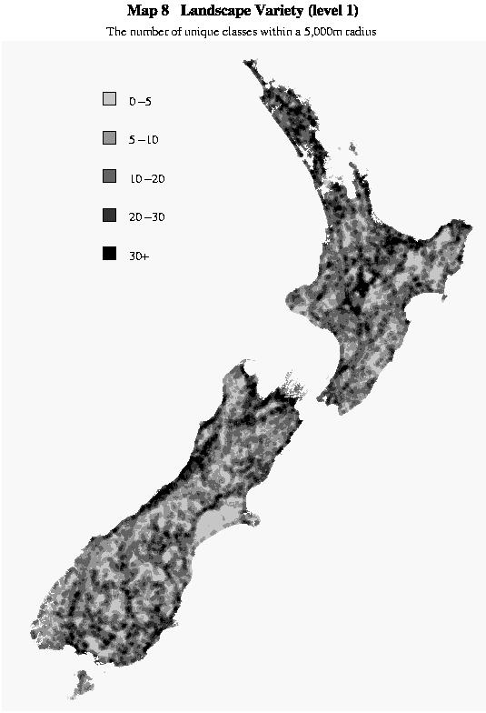
As previously stated, the main purpose of a landscape classification is to provide a frame of reference for public preference studies (psychophysical approach) that assess the quality of different landscapes. A landscape classification can also be used to map variety by calculating, for each point, the number of unique classes in the surrounding neighbourhood (map 8). Landscape variety has been used to assess landscape quality, although the validity of this has not been proven (Arthur, Daniel, and Boster 1977). In the past, landscape practitioners used a more intuitive approach, rather than quantitative techniques for assessing variety.
The classification can also be used to obtain statistical information
because it provides an inventory of the resource. The digital representation
of the landscape classification contains both the Regional Council and
Department of Conservation conservancy boundaries, so statistics can be
obtained on these regions. The benefit of the New Zealand-wide classification
is that regional statistics can be put into a national perspective. Table
5 shows an example, using the Canterbury Regional Council boundary, of
the type of statistics that can be generated. A selection is made using
the level 2 classification for classes that are coastal. These selected
classes are then listed showing the name of the class, the frequency of
this class in the region (number of discrete areas), the total area of
this class in hectares in the region and the percentage of the total area
in New Zealand that exist in the region. Similar statistics can be easily
produced for any other region in New Zealand.
|
1
2
3
4
5
6
7
8
|
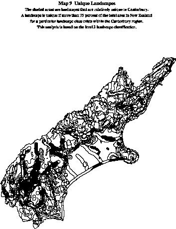
These statistics can be used to map unique landscapes. Map 9 shows landscapes that are unique to the Canterbury region. This is based on an analysis of all the different types of landscapes in New Zealand. Uniqueness is dependent on scale and the level of generalisation - two parameters that are rarely specified by landscape researchers. The total area of each class can easily be determined with GIS for a given study area and level of generalisation, and this describes explicitly how unique the classes are. Why the study area and the level of generalisation were appropriate would have to be substantiated, but that is another matter. With GIS, uniqueness of an area can be calculated for a range of different scales and for a range of different levels of generalisation. Uniqueness of a particular landscape type does not necessarily mean that it is a valued landscape, as some highly modified landscapes can be quite unique. However, if a landscape is perceived as high quality and it is also unique, it becomes particularly important.
Discussion
This landscape classification of New Zealand meets the previously mentioned criteria better than any other landscape classification developed to date. The fact that the classification process is totally explicit, yet sophisticated enough to incorporate the complex nature of landscape, makes this classification stand out from other classifications. The definitions and classes used can now be questioned, and the classification can evolve as our understanding of landscapes improves. The use of GIS has allowed consistent classification across the whole of New Zealand.
This classification, combined with public preference research, will enable planners to determine nationally significant landscapes as required under New Zealand law (Resource Management Act). The classification of New Zealand's landscapes enables development of sound management practices, which are more likely to withstand the scrutiny of planning law than current practises.
The impacts of different modifications to the landscape depend on the context of the landscape. A new hotel in an area that already has a few hotels might not make too much difference to the quality of the landscape. The vegetation and the landform also affect the impact, as hilly and forested areas may hide the visual impact of buildings. It is for this reason that the landscape classification incorporates vegetation and landform. A landscape classification that just considers degrees of modification would not be that useful.
The approaches used for developing the New Zealand landscape classification could be applied to other regions of the world if suitable data sets were available. Some modifications may be required to incorporate issues that may be important to a region; however, this would not pose a problem to a process that can be easily altered and reapplied. The author is currently working on a Welsh Landscape classification with the Wales Countryside Commission and the MaCaulay Landuse Institute in Scotland
Perceptual research into landscape quality would probably reinforce the value of unmodified landscapes such as wilderness areas. Everybody would agree that no wilderness area in the world is safeguarded against some form of development. Often the most contentious landscape planning issues are associated with landscapes on the fringe of wilderness status. The contention is often compounded by the lack of understanding over landscape impacts and public perceptions. Given that landscapes are so valuable to people and that there is so much contention, more research on landscapes is needed. This research should utilise a landscape classification to ensure that the research can be compared with other research and applied to other areas. A landscape classification improves communication and provides a sound framework for research.
References
Amedeo, D. Pitt, D.G. and Zube, E.H. (1989) Landscape feature classification as a determinant of perceived scenic value. Landscape Journal, Vol. 8, No. 1, 36-50.
Appleton, J. (1975) Landscape evaluation: the theoretical vacuum. Transactions of the Institute of British Geographers, 66: 120-123.
Appleton, J. (1980) Landscape in the arts and the sciences. University of Hull, U.K.
Arthur, L.M. Daniel, T.C. and Boster, R.S. (1977) Scenic assessment: An overview. Landscape Planning, 4, 109-129.
Countryside Commission for Scotland, (1970) A planning classification of Scottish landscape resources. Countryside Commission. Perth, Scotland.
Countryside Commission for Scotland, (1988) A review of recent practice and research in landscape assessment. Countryside Commission. Perth, Scotland.
Daniel, T.C. and Vining, J. 1983 Methodological issues in the assessment of landscape quality. In: Altman, I. and Wohlwill, J.F. 1983 Behaviour and natural environments. New York; Plenum Press.
Dearden, P. (1989) Societal landscape preferences: A pyramid of influences. In: Dearden, P. and Sadler, B. (1989) Landscape evaluation: Approaches and applications. Western Geographical Series. Vol. 25.
Duffield, B.S. and Coppock, J.T. (1975) The delineation of recreational landscapes: the role of a computer-based information system. Transactions Institute British Geographers, 66(1), 141-148.
Jackson, J.B. (1984) Discovering the vernacular landscape. Yale University Press, New Haven.
Jones, M. (1991) The elusive reality of landscape. Concepts and approaches in landscape research. Norsk Geografisk Tidsskrift, 45, 229-244.
Haines-Young, R.H. and Petch, P.R. (1986) Physical geography: Its nature and methods. Paul Chapman Publishing, London.
Rhind, D. and Hudson, R. (1980) Landuse. Methuen, London.
Swaffied, S.R. (1991) Roles and meanings of "Landscape". Ph.D. thesis, Lincoln University.
Tomlin, C.D. (1990) Geographic information systems and cartographic modelling. Prentice-Hall, New Jersey.
Zube, E. Sell, J. and Taylor, J. (1982) Landscape perception: Research, application and theory. Landscape Planning 9: 1-33.
Zube, E.H. (1984) Environmental evaluation: Perception and public policy.
Cambridge University Press.