Steven B. Case, scase@kancrn.org
Humans have a predisposition to learn in certain domains and students in particular, are engaged in making sense of their world. The Kansas collaborative Research Network (KanCRN) creates a learner-centered and knowledge-centered virtual research community that supports deep understanding. KanCRN research creates an environment in which GIS is used as a tool to allow students to learn by doing, refine their understandings, and build new knowledge. GIS technology helps learners visualize difficult to understand concepts and allows them to combine their data with a vast array of existing information. In addition, the underpinning cognitive elements of students interacting with a GIS create an interesting field of study between science, geography and education. It is the intent of this presentation to demonstrate an environment where the current findings of the cognitive sciences, supported by the use of GIS technology, facilitate student understanding.
Humans have cognitive predispositions to learn in certain domains. Young children in particular are engaged in making sense of their world. The KanCRN Collaborative Research Network, KanCRN (http://kancrn.org) is creating a learner-centered, virtual research community that supports student attempts at understandings the natural world. The KanCRN community has grown to include teachers and students from 499 classrooms in 360 schools in 43 states, and nine countries. The KanCRN community works within a specific research curriculum model to collaboratively collect and analyze data. The natures of data collected over this network means that it frequently has both space and time components associated with it. One important analysis tool that helps students make sense of this kind of data are Geographic Information Systems (GIS). GIS can assist students in not only discovering underlying patterns from data, but it also allows students to learn by doing, refine their understandings, and build new knowledge as they work. The use of GIS technology allows learners visualize difficult to understand concepts and stimulates them to combine their data with the vast array of existing information. In addition, the underpinning cognitive elements of students interacting with a GIS create an interesting field of study between science, geography and education. The combination of extended inquiry and GIS may help us understand the process of learning.
Developing students' understanding of the nature of science is an objective of all high quality science instruction. Recent efforts to reform science education in the United States (AAAS, 1993, NRC, 1996) have strongly emphasized this understanding as an essential component of general scientific literacy. More specifically, the standards say that, "Science as inquiry is basic to science education and a controlling principle in the ultimate organization and selection of students' activities. The standards on inquiry highlight the ability to conduct inquiry and develop understanding about scientific inquiry. "Students at all grade levels and in every domain of science should have the opportunity to use scientific inquiry and develop the ability to think and act in ways associated with inquiry, including asking questions, planning and conducting investigations, using appropriate tools and techniques to gather data, thinking critically and logically about relationships between evidence and explanations, constructing and analyzing alternative explanations, and communicating scientific arguments." Geography holds an important position in the history and development of scientific thinking. It was the geographic proximity of related species that led Alfred Russell Wallace to conclude, "every species has come into existence closely coincident both in space and time with a pre-existing closely allied species", bringing to light one of the most basic patterns of nature, biologic evolution. Data with spatial components is as critical to understanding gene flow as it is to understanding the range and distribution of species. In the physical and earth sciences the spatial nature of data is equally important; molecular modeling and geologic time each require a precise understanding of locational relationships.
Scientific research drives the development of KanCRN project-based learning. KanCRN is a curriculum project that attempts to fulfill the vision of the national efforts to reform science and technology education. Within the KanCRN project-based learning environment, GIS and spatial thinking materials are linked to an inquiry-based science curriculum. This is creating a research environment in which teachers have the necessary support for students to work in an inquiry-based learning environment. Using a collaborative research community that includes researchers, community mentors, teachers, and students, KanCRN facilitates the creation of a learning community that transcends geographic barriers and allows collaboration throughout the nation on meaningful research.
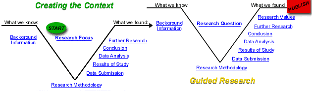
Figure 1: Research Curriculum Model
Research project development and guidance for students in the KanCRN community comes in the form of a modified V-diagram. (Gowin, 1977; Novak and Gowin, 1984) The V-diagram is designed as an organizational structure to help students and teachers navigate through a research project. With an awareness of research showing that most teachers and students believe that all scientific investigations adhere to an identical set and sequence of steps known as the scientific method, the V-diagram was chosen to challenge the perception of a very linear research process. The V-diagram is flexible enough to allow for the representation of how research proceeds in different disciplines while addressing the multitude of circumstances. Along with the flexibility of the V-diagram, there is enough structure to give guidance to the novice researcher and allow for the organization of knowledge. The design helps teachers facilitate student work and provides a tool for the explicit teaching of the nature of science.
The Creating the Context V-diagram, the left of the two V-diagrams, reflects the view that good research questions emerges from a rich context of understanding. It is difficult for students to ask good research questions: questions that go to the heart of what they want to know. The activities and experiences organized around that the Creating the Context V-diagram are a set of very deep, very rich, experiences that bring a much greater level of understanding to the student. The activities of Creating the Context include engaging background information, standardized methods of measurement, active experience in gathering and analyzing data and discussion about what is known and not known on a specific research area. These activities serve as a focus for the research area but are not a research project. They are intended to help develop the skills, activities, and some of the content of science. This research focus creates the context from which a research question emerges. It is the development of good research questions that drive scientific research in the KanCRN research model.
The V-diagram on the right, the Guided Research, represents the research process driven by very specific questions that develop during the activities of Creating the Context. In the early stages of the KanCRN project we did not offer Guided Research on our projects. It was felt that it would be better if students generated their own questions and developed their own research and that this would be the most meaningful way for the students to engage in research. The problem that emerged was that most students, and frankly many teachers, had not engaged in scientific research. The task of creating a good research project seemed too large and daunting. It is not unlike the problem that many graduate students face. The Guided Research Area is provided as an authentic, meaningful research project that allows students to engage in research without the need to develop the entire process on their own. It is designed to be a tutorial that takes students through a research project and asks them to stop, reflect on and discuss each aspect of research as they progress. Each step of the guided research is interactive and asks students to contribute the new information they have developed as they proceed. When they are done, they will have gone through all parts of a research project and will have gained some experience with the process.
In the Common Sense of Science, Bronowski states, "To my mind, philosophers put the cart before the horse when they say that science constructs a world by sorting out what the experiences of different people have in common. On the contrary, the practice of science supposes the existence of a real and a common world, and assumes that its impact on each individual who is part of it is modified by him in a way which constitutes his personal experience. We do not construct the world from our experiences; we are aware of the world in our experiences. Science is a language for talking not about experience but about the world.
While the methods and number of steps used in developing scientific knowledge may vary from one investigator to the next, scientific methods usually involve the alternation of two types of activities, the observational and the explanatory. It is best to give students a range of options on working with data and allow them to experiment with what is going to work for them. KanCRN uses Geographic Information Systems, Stella modeling program, descriptive statistics, and basic math to help students look for these patterns in data. Geographic Information Systems are a particularly powerful tool in helping student in scientific process.
In GIS, the divisions of traditional mapping are shattered, allowing for the creation of maps that display geographic data in combination with the supporting thematic layers. Such data has proven invaluable for solving many real-world problems, from tracking delivery vehicles, to recording details of planning applications, to modeling global atmospheric circulation. The layers contained within a GIS have two distinct informational components: location and a description or attributes of that place. Each of these components is critical in analyzing spatial relationships between data layers. For example, a layer that contains student-collected locations of the Scissor-tailed flycatcher, a bird common to the Midwest, might be placed atop a layer of vegetation classification and hydrology. In analyzing the map data, a pattern may emerge for nest location, perhaps close in a specific vegetation type or near moving water. The range of GIS applications also includes image analysis, three-dimensional analysis and modeling. This expands the range of data with location and descriptive components so that areas of analysis can range from molecular structure to global change issues. Traditionally, mapping techniques have allowed for only simple descriptions of where things occur. Such maps seldom have enough relevant descriptive information.
The recent publication, How People Learn (NRC, 1999) is a detailed look at the knowledge about learning emerging form the cognitive sciences. Understanding how students learn and incorporate information has many important implications for GIS and for the KanCRN project. The report suggests that some newer technologies are more interactive, making it easier to create environments in which students can learn by doing. KanCRN is attempting to take advantage of this learning. Processes of learning and the transfer of learning to new situations are central to understanding how people think. Creating meaningful, authentic work for students helps this transfer to real world problem-solving. Educators hope that students will transfer learning from one problem to another within a course, from one year in school to another, between school and home, and from school to workplace. It is the assumptions about transfer accompany the belief that it is better to broadly "educate" people than simply "train" them to perform particular tasks. KanCRN creates new opportunities for curriculum and instruction by bringing real-world problems into the classroom for students to explore and solve. GIS is used as an analysis tool to create an active environment in which students not only solve problems, but also find their own problems. This approach to learning is very different from the typical school classrooms, in which students spend most of their time learning facts from a lecture, their text and doing the problems at the end of the chapter.
The applications of GIS in KanCRN allows for scaffolding that enables learners to do more advanced activities and to engage in more advanced thinking and problem solving than they could without such help. KanCRN project-based learning using GIS are designed to draw both from knowledge about human cognition and from practical applications of how technology can facilitate complex tasks in the workplace. These designs use levels of GIS use to scaffold thinking and activity, much as training wheels allow young bike riders to practice cycling when they would fall without support.
Before students can really learn new scientific concepts, they often need to re-conceptualize deeply rooted misconceptions that interfere with the learning. Students spend considerable time and effort constructing a view of the physical world through experiences and observations, and they may cling tenaciously to those views, however much they conflict with the real world, because they help them explain phenomena and make predictions about the world. One instructional strategy, termed "bridging," has been successful in helping students overcome persistent misconceptions. The bridging strategy attempts to bridge from students' correct beliefs to their misconceptions through a series of intermediate analogous situations. GIS representations and the analysis of the representations allow for conceptual bridging to occur.
GIS is one of these emerging educational technologies that develop contextually rich student learning. Students can construct understandings of the natural world by creating visual patterns in data. This kind of work is at the heart of both scientific inquiry and constructivist learning. For student researchers, GIS allows for infinite variation in their search of patterns and expands the data that can be included in their search. Using this advanced computer application designed for collecting, storing, manipulating, and displaying data not only expands the data students’ look at, but also how they look at it. GIS can easily accomplish simple tasks such as mapping location, however it can also handle more complex tasks such as, plotting the density and/or frequency of a particular event. GIS will allow more sophisticated tasks, such as finding data points near a particular feature on a map. Perhaps the most complicated and useful tasks a GIS can undertake is displaying data that shows change over time or displaying data using a three-dimensional perspective.
How do human beings acquire knowledge of the world? Since different and frequently faulty models of the world are employed, securing accurate and meaningful knowledge is difficult. Methods of research and data analysis derive their value from the contributions they make to our understanding. Scientific inquiry is one way of constructing a personal understanding of the natural world and then tests that understanding against the reality to develop valid and useful knowledge. GIS dramatically extends the abilities of students to engage in these activities. Too much of school involves students preparing for life, instead of taking part in it. Education is a community building activity and students need to be viewed as active and important members of the community. The function of school is not to prepare the student for the next step in school or in life. Education can be and should be used to live life immediately, to the benefit of the individual and to the benefit of the community. KanCRN projects engage students in meaningful, authentic work, that makes a contribution to the human understanding of the way things work. Students can make meaningful contributions while learning the tools that will allow them to make meaningful contributions throughout their life.
American Association for the Advancement of Science. (1993). Benchmarks for science literacy, New York, NY: Oxford University Press.
National Research Council (NRC). (1999). How people learn: Brain, mind, experience, and school. Washington, DC: National Academy Press.
National Research Council (NRC). (1996). National science education standards. Washington, DC: National Academy Press.
Steven B. Case
Project Director, KanCRN Collaborative Research Network
Center for Research on Learning, University of Kansas