Phase III
I joined this project in the June of 1999. I was very excited about the idea of working
with an online interactive map. For
many years, GIS was thought of as a product for geologists and mapping
experts. Today, GIS can give even beginning users access to
any information you could think of with a geographical component. When I first joined the Real Estate Project,
I had no experience with GIS software.
I began learning about the application through books and the ArcView
tutorial.
In refining the real estate web site, we were trying to make it user friendly, intuitive, simple and attractive. We wanted to make the site
accessible not only for those who are knowledgeable in GIS, but also to those
who know a little about the computer, and who don’t know GIS at all. My job was to find a way to display the data
in an easily understandable format.
We wanted to make visiting our web site an enjoyable and interesting
thing to do - instead of sitting in front of the computer, knowing there was
information there for you, but not knowing how to get it, or sitting in front
of a colorful screen but not knowing what is it about.
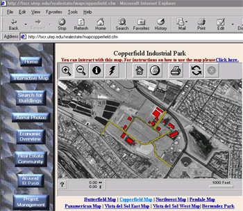
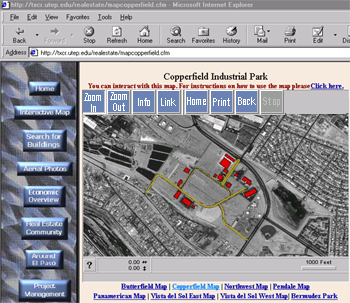
We began by modifying the ArcView code to change the icons on the map server window to text in order
to be more easily understood. For
example, compare two interactive map images, one with icons on the tool bar and
one with text. Even if you notice in
one the tool bar buttons are text and the other, graphic, you may still not
believe how much the text buttons helped those who aren’t familiar with the
meaning of graphic symbols. Trying to
find a way to customize this was a real headache for me. I read through the Internet Map Server
documentation and tried to modify the Java code. The task was tedious.
Then another idea came to me, since we can modify ArcView buttons in
ArcView itself, could we find a short cut to tell the Internet Map Server which images to use for the
applet buttons? The answer was YES.
There is a system script AVETMP.INI, which can be modified to initialize
the map server and define the path for the images. The Java applet uses the images assigned here when Map Café is
called to launch the maps.
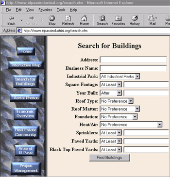
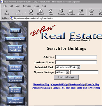
Making the web-site as simple as possible is another principle that we are trying to
follow, while at the same time trying to offer as much information as possible
to the user. Sometimes this criteria
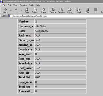
makes things very complex and, at times, misleading. For example, consider two different versions of the search page I
was working with; one with over ten fields you can search by and one with only
four. Which one do you think will give
the user the data they want?
Interestingly enough, it is the simpler one.
We use Cold Fusion for the database management. When we first designed this search page, we
thought users should be able to search for information on each and every
criteria that they were interested in.
From user feedback we found, however, that most of the time the key
criteria was found simply in location and square footage. When a user filled out all the fields, many
times the query was so complex that few if any properties were returned by the
search. By submitting information on
location or square footage only, and leaving the other search criteria blank,
the user was getting more buildings that matched the key criteria. Based on this information, we reduced the
number of fields one could search by.
As I said earlier, we want it to be an enjoyable experience to visit our web site, so how it looks is also
one of the important attributes. One
concern was to adjust the map server window to load as a complete image on a
monitor with 640 by 480 resolution. To
change the size of the map, you can simply go to the Java applet page and
change the width and length there. You
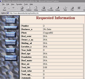
can also change the views by using html to modify the ID.INI script. Another concern was consistency in the
colors and backgrounds of the web pages, especially when viewing the query
results from the interactive map. When
a user would request information from the base map, that information would be returned through a window in ArcView
that did not have the same colors, layout or backgrounds as the Real Estate web
site. In order to resolve this, we
created absolute links calling the web server to bring up the correct
background and page layout. The query
results are then overlaid on top on the page, providing a look consistent with
the rest of the site.
Future plans for the Real Estate Database site include adding interfaces that will allow a user
access to the database in order to add and modify data over the Internet. This possibility would make the site
self-sustaining. For the security of the data, this function would be password
protected. As we work on more projects and learn more about Esri products, we
will be able to use those products to serve different users. We are currently
working on a new web page project for the GIS partners in our region that will
allow them to share data, as well as give the general public access to GIS maps
and information. In the future, we will
use other software applications like Visual Basic and VC++, together with the
mapping software, to make the ArcView projects that work in a way that is
intuitive and informative for all users on our sites.
In closing, I would like to thank Esri for offering us a chance to present at the Users Conference
2000. We believe online interactive
maps are the direction for the future with GIS. Our challenge is to create web
sites that encourage general users to seek the information they need.
Acknowledgements