The Chugach National Forest Plan Revision Process and New GIS Technologies to Support Collaborative Planning
Alan Vandiver, USFS, John Stroud, Esri, David
Neufeld, Esri,
Gary Sherman, Esri, and Karin Preston, USFS.
June 2, 2000
This paper outlines a new planning process used for the Chugach National Forest Plan Revision Process and highlights the importance of the Forest Service as an “Information Broker”. It describes the partnership between the Forest Service and Environmental Systems Research Institute (Esri) to cooperatively develop and test new Internet and CDROM technologies in a planning environment.
We describe recently developed Internet (ArcIMSä) and CDROM (MapObjectsâ) technologies and how they provide innovative techniques to access planning documents and associated spatial data in a simple digital interface. The two projects that were tested are as follows: a CDROM application to access National Forest Management Plan documents with links between text documents and dynamic mapping, as well as spatially referenced comment tools; and an Internet application with the same functionality as the CDROM but accessible over the web using industry standard browsers.
In 1997, the
U.S. Forest Service began revising the Forest Plan for the
Chugach National Forest, the second largest forest in the United
States. To emphasize public involvement and participation
throughout the planning process, the Forest incorporated
Collaborative Learning into the revision plan. In order to
efficiently engage the public, a variety of information
dissemination techniques were used to compliment collaborative
learning.
Early in the
process the planning team identified a need to distribute
information to revision participants with Internet and CD-ROM
applications. The Washington Office, of the Forest Service,
identified the Chugach as a national pilot for implementing the
process and contracted with Esri to develop the applications.
The Internet site will include access to National Forest Management Plan documents hosted at the forest, with links between HTML documents and dynamic mapping. The site will include links to a web forum that will allow discussion of various forest management alternatives by forest stakeholders, including local industry, recreation enthusiasts, and environmental groups. Client-side “markup” functionality will allow users to draw points on to the map, as well as add comments for that spatial location. The comments will then be submitted electronically to the USFS for review in the forest plan update process.
The CD-ROM based application will allow Geographic Information Systems (GIS) to be directly integrated with full, text-based documents, all in one windows based desktop application. In other words, the CD-ROM Template is a simple Wizard driven GIS data and html viewer combined into a single application. This is a particularly useful tool for the distribution of completed documents in a digital fashion that incorporates spatial information, which is vital to natural resource agencies.
The Chugach
National Forest is similar to other national forests across the
country in that many social and ecological changes have occurred
since the initial Forest Plans. The following are some of
the changes since the initial Forest Plan in 1984:
·
In 1989, the Exxon Valdez Oil Spill occurred in the Prince
William Sound. The majority of wildlife species affected by
the spill have not yet fully recovered
·
Cruise boats are docking in communities around and within the
Forest at unprecedented rates. The demand for recreational
activities in the Forest is increasing yearly.
·
A new road is opening this year accessing the western Prince
William Sound. This opens new recreational opportunities
for the 250,000 residents from Anchorage and many nonresident
tourists.
·
Over 100,000 acres of previous National Forest lands have been
transferred to Native Corporations. A significant amount of
land is under new ownership.
·
One of the fastest growing areas in Alaska is the Kenai
Peninsula. This area also has a resident population of
brown bears.
·
Half a dozen communities are trying to maintain subsistence
lifestyles.
Many
Forests across the nation have significant issues such as these.
The Chugach National Forest determined that the traditional
planning process was inadequate for addressing current issues.
The Chugach process utilizes collaborative learning where
participants learn from each others diverse ideas to address
complex resource issues.
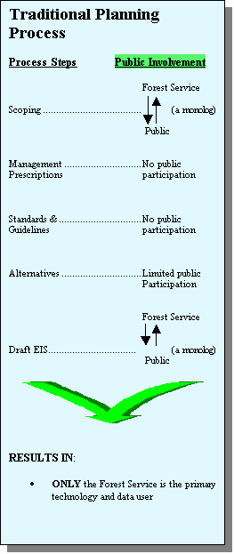
The traditional
revision process has a limited amount of public involvement.
The public generally has two primary opportunities to provide
input: once when the process is initiated and then two to four
years later when the Draft Environmental Impact Statement is
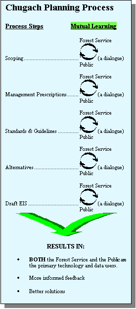
complete (See Figure 1, Traditional Planning Process). The
Chugach National Forest approach is based on collaborative
learning between the Forest Service and the public at practically
every step in the process (See Figure 2, Chugach Planning
Process). As information is learned, initial steps are
reviewed and improved. To effectively implement the new
process it is imperative that software technology and large
amounts of resource data are available to the public and Forest
Service. The Forest Service serves a primary role as an
“Information Broker” by providing technology and data
to revision participants.
| Figure 1. Traditional Planning Process | Figure 2. Chugach Revision Process | |||||||||||||
|
|
|||||||||||||
The core of the
revision process was the formulation of forest management
alternatives. To develop alternatives, the collaborative
learning process emphasized early incorporation of public
comments and continued public involvement. A key component
of the collaborative learning process was opening
Interdisciplinary Team meetings to the public. The open
meetings were very successful; therefore, the Forest Supervisor
also opened his leadership team meetings to the public.
As required by
NEPA, alternatives were developed using an Interdisciplinary
Team. Because of the extensive public involvement, it is
important to understand each participant’s role in the
revision process (See Table 1, Revision Participant Roles).
Table 1. Revision
Participant Roles
| Roles |
Interdisciplinary
Team |
Science
Advisors |
General
Public |
Government
Agencies |
Native
Governments |
Forest
Supervisor |
Regional
Forester |
| Lead
Revision Process |
X |
X |
|
|
|
X |
|
| Write
Revision Documents |
X |
|
|
|
|
|
|
| Critique
and Evaluate Documents |
X |
X |
X |
X |
X |
X |
|
| Develop
Alternatives |
X |
X |
X |
X |
X |
X |
|
| Consult
with Governments |
|
|
|
X |
X |
X |
X |
| Make
Critical Decisions |
|
|
|
|
|
X |
X |
PRIMARY
COMMUNICATION TECHNIQUES
To
encourage participation by a local and national audience and to
implement alternative development, three primary communication
techniques were used:
·
Periodic newsletters were sent to those who expressed an
interest.
·
A series of open Interdisciplinary Team meetings, collaborative
learning workshops, and community meetings were held in various
communities in South-central Alaska. Over 100 meetings were open
to the public. The Interdisciplinary Team held collaborative
learning workshops in all Chugach communities three times
throughout the process.
·
A Web site was developed to disseminate information and provide
further opportunities for people to participate.
Using these
communication techniques, local communities and people from
across the country participated throughout the alternative
development process. Often, updated documents and maps were
posted quickly on the website, based on updated input from the
public meetings. Obviously, the Internet became an important form
of communication with the public.
ALTERNATIVE
DEVELOPMENT STEPS
The alternative
development process involved six primary steps (See Figure 3,
Alternative Development). Participants were given an
opportunity to provide review and input at each step.
Steps 1-6
required three years of intensive collaboration to complete the
products (i.e., Interests, Situations, Management Prescriptions,
etc.). Each step represents months of open dialogue and
discussion. The open atmosphere facilitated a direct link
from the initial 3,000 public comments to the development of six
draft Revision Plan alternatives. As with all Draft Forest Plans,
it is the Forest Supervisor’s discretion to identify the
Preferred Alternative. In fact, the Chugach National Forest
Supervisor was able to build the Preferred Alternative from the
six alternatives the public assisted in building.
Building
Alternatives
The
Interdisciplinary Team knew from the onset that the public was
interested in being involved in the revision process although the
participation far exceeded their expectations. To
effectively involve so many people an “Alternative
Development Toolbox” was constructed. The idea was to
provide access to an array of resource information for people to
build realistic alternatives based on current information and
data (i.e., GIS data, management prescriptions, interests, other
ownership strategies, templates for alternative development,
verbal input from CNF staff). The “Toolbox”
provided equal access to information and a standard alternative
format so all alternatives could be compared on equal footing.
Again, once the “Toolbox” was in the hands of the
participants, utilization of the tools was extensive by the
public. The public subsequently submitted alternatives in the
form of updated CNF GIS maps. Most of the submitted maps were
marked-up paper maps and a few were digital ArcViewâ projects.
Once the
“Toolbox” was complete participants went to work
building their respective alternatives. Alternatives were
developed in Interdisciplinary Team meetings, collaborative
learning workshops, and community gatherings throughout various
South-central Alaska communities. After six months of work,
thirty comprehensive alternatives were developed. Table 2
conveys the level of interest to build alternatives by a variety
of individuals and organizations. A few groups spent hours
building their alternatives but most spent weeks or months.
The Forest Service became an information broker in this process.
As people needed information, Forest personnel determined the
best way to provide the information (i.e., Database, GIS
products, Web products or hardcopy). Again, it was clear the most
efficient manner to disseminate continually updated information
was via digital mediums. The weakness of digital dissemination at
this stage was a simple, integrated, coherent, and free
application for the public.
Figure
3. Alternative Development
Table 2, Primary
authors by alternative
| Alternative |
Primary
Authors |
Alternative |
Primary
Authors |
| No Action | Interdisciplinary Team | 16 | Audubon Society |
| 2 | Interdisciplinary Team | 17 | Chugach Alaska Corp; Alaska Forest Association; Anchorage Snowmobile Club; Alaska Miners |
| 3 | Interdisciplinary Team | 18 | Seward Ranger District Employees |
| 4 | Interdisciplinary Team | 19 | National Wildlife Federation; Wilderness Society |
| 5 | Interdisciplinary Team | 20 | Turnagain Arm Conservation League |
| 6 | Interdisciplinary Team | 21 | Chugach Working Group; Alaska Center for the Environment |
| 7 | Copper River Watershed Project | 25 | Chugach Powder Guides |
| 8 | Focus Group – Cordova Residents | 26 | Cordova Fisherman’s United |
| 9 | Focus Group – Cordova Residents | 27 | Focus Group – Girdwood Residents |
| 10 | Alaska Quiet Rights Coalition | 28 | Friends of Hope, Sunrise and Cooper Landing |
| 11 | Focus Group – Girdwood Residents | 29 | Focus Group – Hope Residents |
| 12 | Interdisciplinary Team | 30 | Focus Group – Hope Residents |
| 13 | Interdisciplinary Team | 31 | Prince William Sound Chapter of Audubon Society |
| 14 | Cordova Resident | 32 | Alaska Wilderness, Recreation and Tourism Association |
| 15 | Interdisciplinary Team | 33 | Alaska Visitors Association |
When the
alternatives were complete the Forest Supervisor directed the
Interdisciplinary Team to review all thirty alternatives and to
recommend a manageable number that addressed the range of
situations. This presented quite a challenge for the
Interdisciplinary Team because most groups had much ownership in
their alternatives. The Interdisciplinary Team decided to
use three techniques to narrow the range: Cluster analysis,
GIS analysis and extensive Collaboration.
Cluster analysis,
a statistical procedure for detecting natural groupings of data,
was used to determine alternatives that were similar. Based
on the analysis the alternatives clustered into six groups.
As all of the
alternatives were described by their authors, some groups were
adamantly opposed to other similar alternatives. To
highlight the similarities and provide an atmosphere for
collaboration, a GIS analysis was completed to disclose
similarities and differences between alternatives in the same
group. This analysis focused each group’s efforts on first
showing areas of agreement and then resolving the differences.
At this time, an opportunity was provided for the
Interdisciplinary Team, all alternative authors, and members of
the public to work together with similar alternatives to find
common ground and produce one composite alternative for each
group. Resource information was also reviewed to insure
that all alternatives could produce the resources desired (i.e.,
timber was present in areas identified for Resource Development).
When the
collaboration was complete the thirty alternatives were reduced
into six composite alternatives. The Forest Supervisor
reviewed the composites and determined they represented an
adequate range of alternatives.
Throughout this process the Forest Service utilized a variety of techniques to distribute information to the public, but soon realized that it lacked the means to distribute large amounts of data and information. It is clear that digital dissemination tools can further enhance the collaborative learning process.
DIGITAL
DISSEMINATION TOOLS
Most, if not all, aspects of any forest planning process use digital tools and information. The output from the current system is a printed-paper document. While the paper document is useful and many people are accustomed to this medium, it is increasingly important that the Forest Service begin using CD-ROM and Internet mediums in the planning process. Digital publication of Forest Plans can reduce dissemination costs, increase transfer speeds to stakeholders and assist in improving the planning process.
The current forest-planning framework has the goal of building a paper-based document. Over time, given the changes in public expectations, the need has arisen to publish digitally. With the knowledge that forest plans will be published digitally, it is crucial to adopt a new digital planning framework that is consistent with both the CD-ROM and Internet formats. Without this, much time and effort will be expended unnecessarily on format conversion exercises. A digital planning framework would assist in the development of future Forest Plans by improving efficiencies in the collaborative planning process.
One example of
how the digital planning framework can improve efficiencies is
the ability to receive digital geo-referenced comments from
document reviewers. Not only can Internet map servers be
integrated with forest plan documents to reveal the information
in a geospatial format, but it can be used to automate capturing
and reviewing public input. Once captured digitally, this input
data can be used directly within the planning framework that
builds the forest management revision plan.
ArcIMSä and
MapObjectsâ software are two of the technologies
being evaluated for the new digital planning framework. The
Internet and CD-ROM applications provide access to a virtual
Revision Plan where the public can review the document and
interact with intuitive GIS maps. The text portion of the
document uses hyper-links to ease the integration of text to map
linkage. Both the CD-ROM and Internet applications await the
Draft Revision Plan to go into production. Both applications were
developed to be independent of the data. This allows text and
maps to be updated from the draft and final versions with no
additional programming needed to make the updated version(s)
work. This same concept will allow for the transference of the
applications to other forests with minimal additional
programming.
The virtual plan
format of hyper-linking text directly to interactive maps allows
easy connections from the subject matter to the mapping data
associated with it. For example, if someone wanted to know where
wild and scenic rivers are located, a word search tool is used to
identify the string “wild and scenic” and a list of
hyperlinks is returned directing users into the textual document.
Once found, the word “wild and scenic” may be
hyper-linked to the “wild and scenic” map for a visual
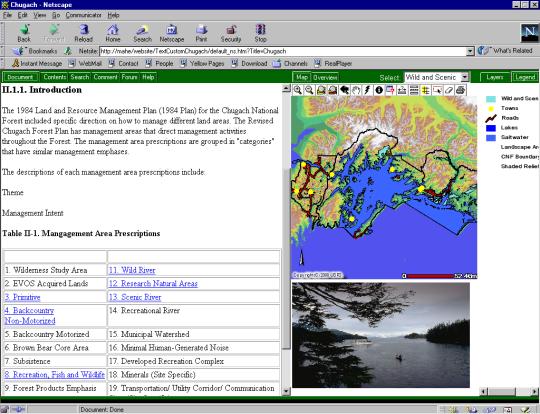
representation as shown in Figures 4 and 5 below.
The Chugach National Forest will be incorporating this new technology into the Draft Environmental Impact Statement and Forest Plan this summer. The Internet application will be available late summer at http://arcticsun.wr.usgs.gov/website/chugach/.
Figure 4. CD-ROM Application in the Text view
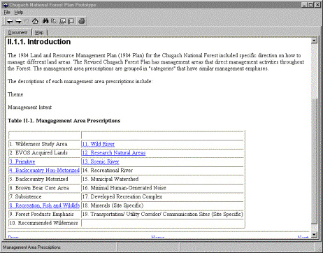
Figure 5. CD-ROM Application with in the Map view
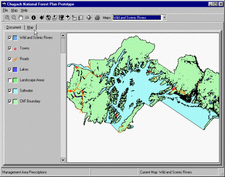
Figure 6. ArcIMS
(Internet) Application
The Chugach
revision process showed that complex resource issues could be
addressed in an open public environment. It also revealed
that the process is “Information Critical”. To
keep the collaborative learning environment productive, the
Forest Service needs to be an efficient information broker.
Many digital tools were used to create and provide information
yet, inevitably, future tools will need to be developed.
Integrating Internet and GIS technologies allow for a robust
digital forest revision plan to be created and disseminated on
both CD-ROM and Internet. A digital framework has begun with this
pilot project that incorporates new planning methods and
technology to capture and disseminate forest revision plans.
ACKNOWLEDGEMENTS
John
Steffenson, Esri –Denver and Wanda Hodge, USFS.