Consequences Assessment Tool Set (CATS) is a PC ArcView application for predicting hazards from natural and technological phenomena and assessing consequences from those hazards. Hazards include those from hurricanes, earthquakes, Weapons of Mass Destruction (WMD) and conventional explosives. CATS allows the user to create realistic scenarios for training and planning, assess affected population and infrastructure quickly and accurately based on real-time weather information, facilitate initial resource deployment and assess needs and locate resources for a sustained response. CATS is a product of the Defense Threat Reduction Agency (DTRA) and the Federal Emergency Management Agency (FEMA).
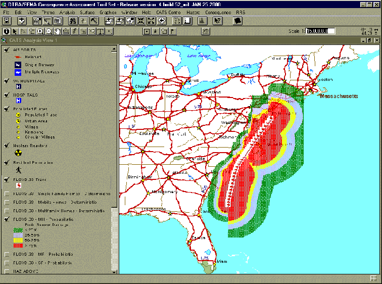
The Consequences Assessment Tool Set (CATS) was born out of cold war technology to address issues associated with hurricanes, including structure damage, population displacement and response sustainability. Science Applications International Corporation (SAIC) correlated a wealth of data on structural damage from atmospheric nuclear tests with hurricane gust characteristics to create a robust damage assessment methodology. SAIC melded this methodology with the power of the ArcView geographical information system (GIS) and demographic and infrastructure data. The result was a unique tool that could be used to anticipate the consequences of a hurricane, preposition supplies and identify areas most likely to require Federal financial support. The value of CATS was recognized with national awards, including the Federal Leadership Award, a Special Recognition Award for Public Service and, finally, the Ford Foundation Innovation in American Government Award. On a more practical level, CATS has been used by the Federal Emergency Management Agency (FEMA) to support its hurricane response activities since hurricane Andrew in 1992. The success of CATS in supporting response to hurricanes from Emily to Floyd has made it the gold standard in emergency management software. The first figure shows expected probability of severe damage to mobile homes from hurricane Floyd according to Maritime Warning 33, issued at 5PM, Wednesday, September 15 1999.
Since its inception as a hurricane fighter, the CATS repertoire of natural hazards has been increased to include the tidal surge associated with hurricanes and the awesome destructive power of ground shaking caused by earthquakes. The CATS earthquake consequence assessment capability was in place at FEMA when the Northridge earthquake occurred in 1994. The capability of CATS to predict expected earthquake damage, rapidly and accurately, allowed FEMA to respond to the emergency with exceptional alacrity and effectiveness. CATS damage predictions allowed FEMA to facilitate allocation of Federal relief, minimizing initial proof of loss requirements for property owners in areas designated by CATS as having a high probability of damage.
In 1995 CATS demonstrated its unique combination of rapid response and world wide applicability by allowing the United States to respond to the Kobe earthquake disaster within minutes of the initial report, using the standard geological data set distributed with CATS. Since then, CATS has been used to predict the damage from hurricanes in Latin America and earthquakes in Turkey.
The success of CATS in responding quickly and accurately to natural disasters, in terms of defining the hazard, assessing the potential consequences and characterizing the desired response, made it clear that the same basic technology could be applied to technological or man-made disasters as well. Thus, over the eight years since the inception of CATS, a variety of tools have been added to allow it to support activities related to all manner of events, from those that cannot be easily characterized to those that may be accurately described with detailed models.
CATS allows the user to define a hazard area of arbitrary size and shape in response to incident reports or merely expectation of an event. It allows the user to define hazard areas according to well known conventions, such as the North American Emergency Response Guide (NAERG), a product of the Departments of Transportation of Canada, United States and Mexico, and the Areal Locations of Hazardous Atmospheres (ALOHA) code from the National Oceanographic and Atmospheric Administration (NOAA) and the Environmental Protection Agency (EPA). These provide the means for rapidly defining hazard areas from events involving the release of toxic industrial materials. CATS can use these hazard areas to determine the number of persons at risk, the locations of infrastructure that may provide assistance, such as police, fire department and hospital locations. It can also determine infrastructure at risk, such as schools and government services. CATS can also find all the street locations required to completely interdict the hazard area, including a surrounding buffer area, and list those locations in a convenient table that is interactive with the map display of the road block locations.
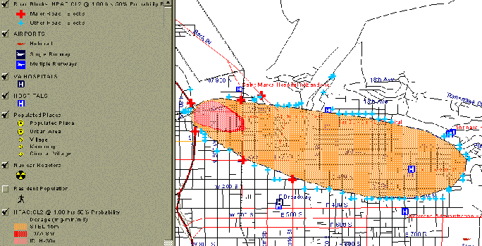
CATS is distributed with the Hazard Prediction Hazard Prediction and Assessment Capability (HPAC), Version 3.2. HPAC is a sophisticated, probabilistic plume dispersion system for radiological, chemical and biological agents. The code uses historical or current time meteorological data to create mass-consistent winds, flowing around large terrain features. HPAC dispersion accounts for uncertainties in meteorological conditions, creating dispersion footprints that reflect a desired level of probability in the outcome of an event. HPAC may be launched alone or within CATS. Hazard calculated with HPAC may be displayed in CATS and used assess the number of persons at risk to exceeding an exposure criterion with a specified probability or the total number of persons expected to suffer effects from such exposure. The following figure shows the extent of a chlorine hazard, one hour after release, calculated using HPAC with local terrain and current winds. Also shown in the figure are all road block locations required to isolate the affected area at the extent of immediate danger to life and health (IDLH) criterion, with 50% probability.
CATS software is PC application that operates within the ArcView GIS with the additional support of the Spatial Analyst and Streetmap extensions. Full installation with all supporting software and room for projects requires approximately 3.5 Gbytes. Esri offers the GIS components as the CATS Bundle, at a special price. CATS software comes with data and modeling capability that allow it to be applied immediately to problems at hand. It is available free of charge to agencies of all levels of government associated with public safety, courtesy of DTRA. State and local government agency requestors are required to pay an annual support fee to cover the costs of technical support and training in new versions of CATS.
CATS is in release Version 4, Build 52. Build 60 is due for release in the Fall, 2000. Features to be added include street routing optimization required to avoid a specified hazard, Spatial Data Engine (SDE) data access, facilitation of user-owned data registration for use in CATS analysis, the upgrade of NAERG to ERG2000 status and the enabling of HPAC to be run using toxic industrial source terms created in ALOHA. Following the release of CATS460, work will begin on CATS Version 5. This will be the first version of CATS to be flexibly configurable, from wholly resident to wholly web based and any combination of web-based and resident components in between.
To obtain CATS452 as part of the Esri CATS Bundle, contact
Esri: Russ JohnsonIf you already have the required Esri software, request CATS452 software by contacting
SAIC: Patti Barone