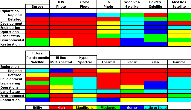
This matrix illustrates the estimated suitability of various remotely sensed data types and related information for the mining industry. This matrix is subjective and may not apply in other situations.
The mention of any specific product does not constitute endorsement.
Each of the column headings indicates a generic type of technology rather than a specific sensor or product. The row headings represent different aspects of the mining life cycle, from exploration through development and operations to recovery and reclamation. Each technology has different qualities which make it more or less suitable at each phase.
Survey is traditional ground survey techniques, including GPS surveying.
Photo represents the film-based technologies:
• B/W or panchromatic.
• Color.
• color infrared (I/R).
Satellites are broken down by spatial resolution, and may not
represent the divisions used in other fields:
• Wide resolution includes
the weather and wide area earth sensing satellites such as AVHRR
and WiFS.
• Low resolution includes most
of the traditional land sensing instruments such as Landsat, SPOT,
and LISS-3.
• Medium resolution is represented
primarily by IRS Pan, but may include the forthcoming SPOT 5m
pan sensor.
• High resolution includes
the new generation of mapping satellites such as IKONOS, OrbView
3 & 4, and Quickbird.
• Panchromatic is generally
1-m pixel.
Hi Resolution Multispectral is usually 4m pixels in the visible and near-IR range on satellites, but also includes a plethora of airborne systems including the DMSV instrument.
Hyperspectral includes airborne and satellite platforms with a dozen or more spectral channels. This includes AVIRIS and ESSI, plus OrbView 4.
Thermal includes any thermal IR channel of any spatial resolution on airborne or satellite platforms, including Landsat TM, FLIR systems, Sensys systems, and so on.
Radar includes the entire side variety of radar systems, from airborne mapping systems to earth observing satellite systems, including Radarsat, ERS, and Intermap.
Geo is the entire suite of geologic data, particularly geologic mapping, geochemistry postings and surfaces, and geophysical studies not covered elsewhere in this matrix.
Gamma is the rather specialized set of geochemical data produced from spectral gamma-ray surveys.