
Location of Norcross Wildlife Sanctuary and Brimfield State Forest
ArcView was selected as the software for the NWF despite some severe limitations that the software has for managing polygon data sets. ArcView's native ability to edit and maintain polygon data is extremely poor, mainly due to the lack of topology in shapefiles. The better Esri software choice for managing polygon data sets is Arc/INFO, however, Arc/INFO also has some severe limitations for small non-profit groups like the NWF. Arc/INFO has high initial start-up costs for purchasing a software license and hardware. The NWF probably could have managed the start-up costs, however, the technical knowledge required to manage and operate an Arc/INFO system would have been beyond the means of the NWF. We thought that by using Avenue programming to add data editing functionality to the ArcView system it would become a viable choice for the NWF. The result of our work is an extension that dramatically improves data entry and editing features of ArcView and makes it possible to manage polygon data sets without purchasing a more complicated software such as Arc/INFO. With the NWF/DEM Data Editing Extension it is now possible for small land management organizations to enter the GIS field for a relatively low cost and still produce data that is accurate and easy to maintain.
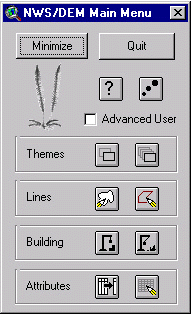 The most significant problem with using ArcView for managing polygon data sets is that shapefiles lack topology. Topology refers to "the spatial relationships between connecting or adjacent coverage features (e.g., arcs, nodes, polygons, and points)."2 In a polygon data set, Arc/INFO stores topological information on each arc consisting of a start node location, an end node location, the polygon to the right of the arc and the polygon to the left of the arc. This means that two polygons with a coincident boundary can share the arc that forms the boundary. Because ArcView shapefiles do not contain topological information, two polygons with a coincident boundary cannot share an arc. For a shapefile, each separate shape has its own arc, meaning that for a coincident boundary two arcs will occupy the same geographic location. This creates editing difficulties when working with the data because if you try to alter the coincident boundary you must edit each polygon separately, which is difficult to do correctly and often results in data errors. In order to get around this problem a routine was created called unbuild that will convert the polygon shapefile into a polyline shapefile. For polygon data sets that contain attribute data a point shapefile can be created that will store the attribute data while the arcs are being edited. Once edits are completed a build routine converts the polylines back into a polygon shapefile and incorporates the attribute data from the corresponding point shapefile. The build algorithm becomes cumbersome for larger data sets because shapefiles were not intended to be edited in this manner. In order to minimize this problem it is possible to work with a portion of the polygon data and then incorporate that portion back into the original data once edits have been made. Build and Unbuild are launched from the Main Menu, as are additional dialogs for survey coordinate entry, feature editing, and attribute entry.
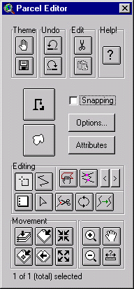 Most editing functions of the extension are carried out from the Parcel Editor dialog which provides both a set of editing tools and an improved editing environment for ArcView. The Parcel Editor dialog improves the ArcView editing environment with selection color, node markers and intersection markers. ArcView displays selected arcs of an editable theme (that is not in vertex edit mode) by placing "handles" around the shapes. Using the "handles", the shapes can be stretched and shrunk. When managing land (and most other polygon and line data) editing the data by manipulating the "handles" is rarely used. When many arcs are selected that are close to each other the handles make it very difficult to determine which arcs are selected. In the Parcel Editor dialog selected arcs of an editable theme are colored yellow, except when the theme is in vertex edit mode. By coloring the arcs instead of using "handles" it is much easier to determine which arcs are selected. To aid the editing process, important nodes are displayed with different colors. Dangle nodes are colored red and pseudo nodes are indicated with blue points. Arcs that start and end with the same point have their node colored green because the build routine cannot handle single arc polygons. One of the most useful features of the Parcel Editor is the ability to mark intersections. Similar to Arc/INFO if there are intersections when you try to build a shapefile the process will fail. In order to avoid this a intersection marker routine finds problem intersections and marks them with magenta points that can be viewed in vertex edit mode.
The Parcel Editor dialog contains many similar functions to the ARCEDIT module of Arc/INFO. Split, move and rotate tools are graphically oriented but otherwise perform similarly to the ARCEDIT commands with the same names. There is also a tool called the grabber which will copy arcs from an active polygon or line theme (the tool also works on coverages) and add them to the editable theme. This tool is similar to the ARCEDIT put command. Snapping end nodes in the Parcel Editor is simpler than the snap function that comes with ArcView. Snapping can be turned on with a check box and dragging a circle on the view sets the snap distance. Arcs with an "undershoot" can be extended to the next arc using an interactively set tolerance (like snapping) and the selected arc will be extended until it meets the first additional arc within the tolerance range. The arc that is intersected by the extension is split and the three arcs are connected at the new node.
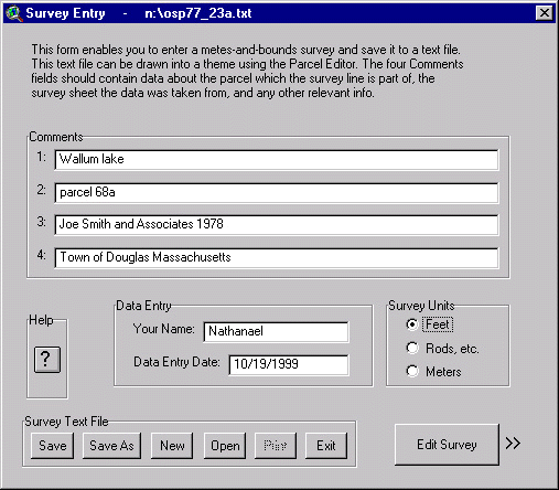

Survey Entry Dialog (Page 2 - Coordinate Entry)
 Nathanael Lloyd
GIS Coordinator
MA Department of Environmental Management
100 Cambridge Street
Room 1404
Boston, MA 02202
(617) 727-5227 x336
nathanael.lloyd@state.ma.us
 David Kimball
GIS Coordinator
Norcross Wildlife Sanctuary (www.norcrossws.org)
davidfkimball@hotmail.com