|
As a robust design tool, the STK/GIS Extension can create facilities, area targets, and coverage regions in STK whose boundaries are specified according to an unlimited number of complex demographic, environmental, and other geographically-referenced properties. As a powerful analysis tool, the STK/GIS Extension enables the user to analyze and associate geographically-referenced data with STK sensor footprints, sensor swaths, area targets, and coverage regions by referencing them against numerous GIS detailed information databases.
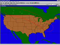
Using the STK/GIS Extension between ArcView and STK, the user can define points or regions by any number of demographic, environmental, or other geographically-referenced specifications (e.g., urban populations, vegetation regions, political borders). These points or regions can then be imported by STK and converted to facilities, area targets, and/or coverage regions. The user can also initiate a GIS analysis by exporting STK sensor swaths and coverage areas into ArcView, then using ArcView to determine various types of information about those areas.
Key Features
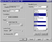
Exchanging and leveraging STK and GIS information. Users are able to produce GIS industry-standard "shapefiles" through detailed GIS analyses, then use STK to import the shapefiles and optimally-create STK facilities, sensor footprints and swaths, area targets, constellations and coverage regions. Similarly, users can take these STK data (antenna contours, sensor swaths, area targets, facilities, and instantaneous sensor footprints) and export that data as shapefiles to perform informative GIS analyses within ArcView GIS or any other GIS software package.
Perfect coverage design and analysis tool. STK/GIS with STK/Coverage is an unbelievably powerful design and analysis tool. In a design environment, a satellite television provider may wish to create a geostationary satellite sensor footprint and position it so it covers the maximum number of middle-income households possible. Using the STK/GIS bundle with STK/Coverage and a GIS income database, the user can converge upon an optimal design. As an analysis tool, a current satellite operator may use the STK/GIS bundle to analyze what geographical and demographical environments their satellite passes over each day, such as people, automobiles, homes, cellular areas, zip codes, televisions, fast food restaurants, in order to maximize their assets and revenues.
Real-time GIS display and analysis. Using STK/GIS and ArcView GIS with the ArcView Tracking Analyst, the user can receive, process, analyze, and display real-time data, such as that received from the Global Positioning System (GPS). STK/GIS with this ArcView GIS bundle allows the user to conduct temporal and spatial GIS analyses of this data in real-time, visualize it within both STK and ArcView GIS, and understand the association moving objects, such as military vehicles, aircraft, satellite sensors, ships, have within their GIS environment.

