Fuelwood volume inventories typically involve the generation of models predicting the volume of woody biomass from easily measured variables such as stem diameter and total height. Such models have been shown to be capable of producing reliable estimates of fuelwood volume conditions for individual trees as well as for forests on a per area basis (volume/unit area). Although valuable, this technique does not provide resource managers and policy makers with information documenting the distribution of fuelwood resources or the spatial variation of density conditions occurring within forested sites.
Remotely sensed imagery acquired from satellite platforms is increasingly being used to conduct assessments of fuelwood resources in ecosystems found within this geographic zone. Much of this work has focused on the extraction of Anderson Level I land use categories from Landsat Thematic Mapper (TM) and SPOT multispectral satellite images (Anderson et al, 1976; Smith et al, 1990; Chuvieco et al, 1996; Klaver et al, 1997; Keane et al, 1999). While useful, this level of information provides little to no data specifying fuelwood volume conditions of forests within this ecosystem. This is due to the relatively poor spatial resolution characteristics of these satellite sensors.
It has been shown that spatially continuous data describing the distribution of fuelwood volume conditions within the mediterranean geographic zone may successfully be generated from the interpretation of forest crown closure conditions on color and color-infrared aerial photography (Pillsbury et al, 1979; Brockhaus et al, 1992). Results from these studies indicate that the agreement between mapped fuelwood density classes and actual field conditions may range between 91 and 97 percent. Aerial photography offers the dual advantages of providing imagery with high spatial resolution that is also well accepted as a mapping tool in the management of natural resources. Regional fuelwood volume mapping using aerial photography is, however, problematic. A mapping project conducted by the California Department of Forestry to map fuelwood density conditions throughout the woodland-savanna ecosystem in that state required the interpretation of over five hundred medium scale aerial photographs. Additionally, multi-temporal mapping of this resource will be restricted to once every ten years due to the cost associated with the acquisition and interpretation of the aerial photography used in this mapping effort.
High spatial resolution satellite imagery may provide an alternative to the use of aerial photography in the mapping of fuelwood density conditions within this geographic zone. Until recently the spatial resolution of satellite imagery precluded its use in detailed fuelwood inventories. Even at 10 metre2 (m), the resolution of SPOT panchromatic data, crown closure will be overestimated as openings in the canopy that are less than 10 m will not be seen. However, high resolution imagery acquired from space based platforms, previously only available to military organizations, are now available to the public and private sector. Imagery at 2 m2 and 1 m2 resolution acquired by the Russian SPIN-2 and the IKONOS satellite remote sensing systems respectively are now available for most regions of the world. At these levels of spatial resolution it may be possible to map fuelwood density conditions from satellite imagery by applying the same techniques developed for the use of aerial photography.
METHODS AND MATERIALS
Study Site Description
The site selected for this study is located along the central coast of California, USA, northwest of the city of Paso Robles on the Camp Roberts Military Reservation. This military reservation encompasses 17,000 hectares (ha) of land and is used by the California National Guard for military training exercises. A twenty-two square kilometer segment of the reservation that is excluded from use in training exercises was selected as the study site for this project. Approximately 2,200 ha are encompassed within the site and a variety of fuelwood density conditions occur here. The site selected is located approximately 15 miles northwest of the area used in a study conducted by the author and reported in 1992 (Brockhaus et al, 1992). The focus of this earlier study was on the use of color infrared aerial photography in mapping fuelwood density classes. Significant urbanization has occurred in this area since the time of the previous study precluding its use in this work.
The landscape is typified by low rolling hills and rugged mountains and is part of the Santa Lucia Mountain Range. The highest elevation is in the western section of the site where peaks range from 600 to 1,100 m. The lowest portions are in the east where the elevation is 200 m or less. Streams are typically dry during the summer months and free flowing during the winter. Two rivers within the study site flow year round, the Salinas and the Nacimiento. The Mediterranean climate, typical of the area, provides a wet season in winter and a dry season during the summer. The rainy season extends from late November to early March, though light showers may occur during the spring and summer. Highest levels of precipitation, 280 mm, occur in the range of hills and mountains nearest the Pacific Ocean coastline with decreasing amounts down to 150 mm farther inland. Average temperature during the winter is 9(C and the average daily minimum is 1(C while the average daily maximum is 33(C. Relative humidity at mid-afternoon in the spring is less than 35%, in summer 15%, and during the winter 40%.
Three of the eleven primary vegetation types found in California occur within the study site: (1) grassland; (2) woodland-savanna; and (3) chaparral (Munz, 1973). Annual grasses such as Bromus mollis, Bromus diandrus, Avena fatua, Danthonia californica, and Hordeum jubatum predominate. Commonly associated with these grasses are herbaceous plants such as Erodium cicutarium and Medicago hispida. Grasses predominate in the winter and spring while herbaceous plants generally are more conspicuous in the summer and fall. The chaparral vegetation type occurs on dryer exposed slopes and includes shrubs such as Larrea tridentata, Quercus durata, Adenostoma fasciculatum, Quercus dumosa, Arctostaphylos glauca, and Rhus diversiloba. Three deciduous tree species dominate the woodland-savanna type. Quercus agrifolia can be found growing on northern protected slopes, Quercus douglasi commonly grows on exposed drier slopes, while Quercus lobata typically are found in fertile valley lowlands. These species are primarily utilized for fuelwood and watershed protection.
Categorization of Fuelwood Density Classes
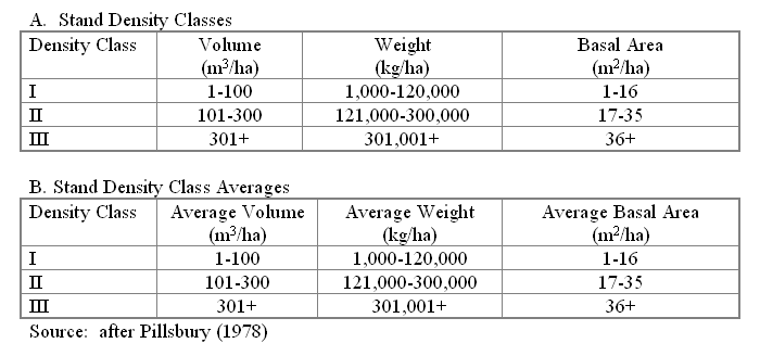
The 1992 study by the author using CIR aerial photography relied upon volume models and basal area relationships established in previous research. These efforts included a stand density characterization study for the woodland-savanna ecosystem in central California that was completed in 1979. This work began with the development of volume and green weight equations for tree species found within this region (Pillsbury and Stephens, 1978). Additional research lead to the generation of a set of criteria for classifying fuelwood stands into specific density classes (Pillsbury, 1979). Three density categories were defined which divided the range of volume and green weight values into three broad groups (Table 1). The final phase of the study resulted in a series of crown closure classes that were shown to correspond to the three volume density categories (Pillsbury and Brockhaus, 1979). The range of crown closure conditions found to be correlated with the fuelwood density categories were 10-35% for density class I, 36-75% for density class II, and > 75% for density class III.
Mapping Fuelwood Density Conditions with Russian SPIN-2 Satellite Imagery
Two meter resolution panchromatic SPIN-2 satellite imagery providing complete coverage of the study site was obtained through Aerial Images Corporation, Raleigh, North Carolina, USA. This imagery was produced from the KVR-1000 camera
TABLE 1
Stand density characteristics for deciduous species in the central coast of California
system onboard a Russian Cosmos spacecraft. A 1000 millimeter camera lens is used to acquire individual scenes that encompass an area of 40 km by 160 km. Film used in the KVR-1000 camera system is sensitive to electromagnetic energy with wavelengths between 510 and 760 nanometers. The imagery was acquired on October 9, 1991 and was cloud free. Data was provided as both a hardcopy film product and in a digital format. The most recent satellite was launched on February 17, 1998 ensuring continued coverage, although not on a systematic basis. An additional satellite, scheduled for launch in late 2000, will provide continuing coverage in the near future. Thus, this type of imagery could be used as part of a long-term fuelwood inventory programme.
All analysis and interpretation of the satellite imagery was performed on a laptop computer. Delineation of the fuelwood density class boundaries was done using the ArcView geographic information system (GIS). Once the imagery was imported into the ArcView GIS a multi-phase approach was taken in the interpretation of the forest canopy crown density and the generation of resulting GIS data layers and associated attribute files. This process included the following steps: 1) when viewed on the computer screen forested sites with homogenous crown densities were identified on the satellite imagery; 2) polygons defining the boundary of these homogenous units were delineated using the on-screen digitizing capabilities of ArcView; 3) the average canopy crown density of each area was estimated ocularly; 4) each delineated polygon was then assigned to one of the three fuelwood density categories (density class I, 10-35% canopy closure; density class II, 36-75% canopy closure; and density class III, >75% canopy closure); and, 5) entry of fuelwood density class data for each polygon into an attribute table associated with the digitized GIS data layer. When completed the GIS data layer contained polygons delineating 95 individual fuelwood stands occurring within the study site and an attribute table documenting conditions interpreted for each stand.
Field Verification of Interpreted Fuelwood Stand Density Classes
One man-week (7 days) was spent in the field documenting fuelwood volumes within the 95 stands delineated on the SPIN-2 panchromatic satellite imagery. Hard copy prints of the satellite imagery, CIR aerial photography, and a global positioning system receiver were used to locate each stand in the field. In some instances the sites were accessible by vehicle, however, in most cases the verification team would be in the field for two-day periods hiking between sites.
Once a stand was correctly located three points were randomly selected within the stand for data collection. A wedge prism was used to make basal area measurements at each of these points and then averaged to generate a single value per stand. Volume (m3/ha) and weight (kg/ha) estimates for each stand were then derived from previously established relationships between basal area and these variables.
RESULTS AND DISCUSSION
An error matrix comparing the fuelwood density class as interpreted on the satellite image to the actual density class for the 95 stands was constructed to determine the accuracy of the interpreted data (Table 2). Elements along the diagonal of the matrix represent sites that have been correctly interpreted on the satellite imagery. Column off-diagonal elements indicate sites that were omitted from the true density class for that site. Row off-diagonal elements represent sites that were interpreted as belonging to one density class when they actually should have been assigned to another category.
An investigation of the error matrix shows that there is close agreement between the satellite interpreted classes and the conditions observed in the field. Of the 95 stands identified on the satellite imagery eighteen were improperly assigned to one of the three density classes. Incorrect classifications on the satellite imagery were always between adjacent density categories. That is, a high-density site was never interpreted as belonging to the low-density class. Conversely, low-density sites were never assigned to the high-density class. Six low-density sites were assigned to the medium-density category. Three medium-density sites were assigned to the low-density category while six other medium-density sites were interpreted as high-density sites. Three high-density sites were included in the medium-density class.
In each of the instances where a stand was assigned to an incorrect density class the crown closure of the polygons as interpreted from the satellite imagery was within 10% of the upper or lower limits of crown closure for that class. This may be a function of the spatial resolution of the imagery, 2 m2. Small openings in the canopy that are less than the spatial resolution of the SPIN-2 imagery may not be visible when viewing the imagery. As a result the crown closure of an individual forest stand would be overestimated.
Interpretation accuracy was analyzed from two different perspectives. The first approach views accuracy from the "producer's" point of view. This is the probability that an area that is actually low-density in the field will be assigned to that class when interpreted on
TABLE 2
Satellite image interpretation error matrix.
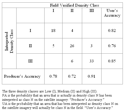
the satellite imagery. Producer accuracy levels were 0.78, 0.72, and 0.91 respectively for the three fuelwood density classes. The producer accuracy of 0.91 for the high-density category could be interpreted as follows; 91% of the fuelwood sites identified as high-density in the field were interpreted as high-density on the satellite imagery. The second method for investigating accuracy views it from the "user's" perspective. User's accuracy is the probability that an area delineated as low-density on the satellite imagery will actually be low-density in the field. User accuracy levels were 0.82, 0.76, and 0.85 respectively for the three fuelwood density classes. The user accuracy of 0.85 for the high-density category would be interpreted as follows; 85% of the sites classified as being high-density on the satellite imagery were actually high-density in the field.
Estimation of canopy crown closure, whether from aerial photography or satellite imagery, is a very subjective process. Thus, these types of interpretation errors should not be unexpected. It is encouraging to note, however, that of the 95 fuelwood stands mapped eighteen of these types of interpretation errors occurred. This indicates that although mis-classification of sites in this process will occur that these errors do no represent a significant component of the total number of stands mapped.
CONCLUSIONS
Results from this study indicate that high-resolution panchromatic satellite imagery may be a reliable form of imagery for mapping the distribution and density of fuelwood stands in the mediterranean geographic zone in southern California. It has also been shown that when the imagery is available in a digital format and incorporated within a GIS that data layers and associated attribute tables may be generated simultaneously with the interpretation of the imagery. Although digital data and a laptop computer were utilized in this study the fuelwood stands within the study site could also have been mapped using large-scale hardcopy image maps of the satellite data. This procedure would be similar to that taken in the 1992 study utilizing CIR aerial photography and could be a viable alternative to those organizations unable to utilize laptop or desktop computers.
Additional types of high-resolution satellite imagery are available, or will be available in the near future, that could also be used to map fuelwood density conditions. Panchromatic one m2 and four m2 multi-spectral imagery collected by the IKONOS satellite are available through the Space Imaging Corporation. It may be possible to attain increases in interpretation accuracy when using the panchromatic IKONOS imagery due to the slight improvement in spatial resolution. Errors in interpretation could increase when using the four m2 data due to the inability of interpreters to see openings in the canopy less than the resolution of the imagery. However, this effect could be mitigated somewhat through a merger of the multi-spectral and panchromatic imagery there bye taking advantage of the spectral and spatial characteristics of both types of data. The next generation of the French SPOT remote sensing satellite will have a panchromatic band with a spatial resolution of two meters. This data will be available worldwide with systematic repetitive coverage. Imagery from each of these systems could potentially be used to map fuelwood density conditions.
REFERENCES
Anderson, J. A., Hardy, E. E., Roach, J. T., and Witmer, R. E., 1976. A land use and land cover classification system for use with remote sensor data. United States Geological Survey Paper No. 964, 29 p. United States Government Printing Office, Washington, D.C.
Ashmann H. A., 1973. Distribution and peculiarity of Mediterranean ecosystems. Ecological Studies, Analysis and Synthesis 11-19. Springer-Verlag, Berlin.
Brockhaus, J. and Pillsbury N., 1992. Spatial characterization of fuelwood resources in the US semi-arid mediterranean geographic zone. Journal of World Forest Resource Management 6: 139-154.
Chuvieco E. and Salas J., 1996. Mapping the spatial distribution of forest fire danger using GIS. International Journal of Geographical Information Systems 10 (3): 333-345.
Keane R., Mincemoyer, S., Schmidt, K., Menakis, J., and Garner J., 1999. Fuels and vegetation mapping for fire management on the Gila national forest, New Mexico. In Proceedings of the 1999 American Society of Photogrammetry and Remote Sensing Annual Convention, Portland, Oregon, 10-15 May, 1999: 272-282.
Klaver J., Klaver R., and Burgan R., 1999. Using GIS to assess forest fire hazard in the Mediterranean region of the United States. In Proceedings of the 1999 Environmental Systems Research Institute User's Conference, San Diego, California, 7-11 July, 1997 Paper 286: 1-11.
Mayer K., Pasof P., Bolsinger C., Grenfell W., and Slack H., 1986. Status of hardwood resources of California. A report to the board of forestry. California Department of Forestry, Sacramento, California.
Munz P., 1973. A California Flora. University of California Press, Berkeley.
Omernik J., 1987. Ecoregions of the conterminous United States. Annals of the Association of American Geographers 77 (1): 118-125.
Pillsbury N., 1978. Hardwood stand density characteristics for central coast counties in California. Central Coast Resource Conservation and Development Area, Salinas, California.
Pillsbury N. and Brockhaus J., 1979. Tree photo volume and weight tables for California's central coast. California Department of Forestry, Sacramento, California.
Pillsbury N. and Stephens S., 1978. Hardwood volume and weight tables for California's central coast. California Department of Forestry, Sacramento, California.
Rumney G., 1968. Climatology and the World's Climate. MacMillan Company, New York.
Smith M., Ustin S., Adams J., and Gillespie A., 1990. Vegetation in desert: I. A regional measure of abundance from multispectral images. Remote Sensing of Environment 31: 1-26.
Zhu Z. and Waller E., 1999. Forest cover mapping for the forest resources assessment 2000 of the food and agriculture organization.
Dr. John A. Brockhaus
Associate Professor
Geospatial Information Science Program
Dept. of Geography & Environmental Engineering
United States Military Academy
West Pt., NY 10996
Email: bj9296@usma.edu
Major Dale R. Manry
Assistant Professor
Geospatial Information Science Program
Dept. of Geography & Environmental Engineering
United States Military Academy
West Pt., NY 10996
Email: bd1408@usma.edu