Juergen Schimetschek and Andreas Siebert - Munich Reinsurance Company, Munich
This paper provides comprehensive technical and scientific information on Munich Re's group-wide Natural Hazard Assessment Network (NATHAN) based on Esri's ArcIMS technology.
NATHAN is an online tool for analysing and displaying both the global and local natural hazard situation on the basis of our World Map of Natural Hazards, published in Esri Map Book (1999) Volume Fourteen. Via the Munich Re intranet, users can obtain quick and precise answers for the risk management of natural perils. The most important tool is the hazard pointer, which allows a qualitative assessment of the natural hazard situation at any point on earth.
By making this extensive body of data available online, we intend to improve the hazard awareness of underwriters who reinsure risks, but also the awareness of their clients and business partners.
The Munich Reinsurance Company - Münchener Rückversicherungs-Gesellschaft or Munich Re for short - is a leading international "insurer of insurers". It operates from its head office in Munich (Germany) and via more than 60 reinsurance subsidiaries, branches, service companies and liaison offices worldwide.
Its business partners are insurers in more than 160 countries. These insurers transfer to the reinsurer parts of the risks they assume - be it in personal lines business or in commercial insurance – and for which they require help in carrying.
Whenever one is faced with the task of assessing a risk or location (no matter where it may be in the world) and the natural hazard factor is to be included, one should know the risk potential from natural catastrophes. The result of the risk assessment may on the one hand have an impact on the design and position of buildings, industrial plants, or infrastructure, and on the other hand influence the design of the insurance product and the premium required.
As a further development of our well-known World Map of Natural Hazards and CD-ROM World of Natural Hazards, the Munich Re Geoscience Research Group has now produced a Web-GIS application called NATHAN.
This product offers entirely new ways of interacting with the system and providing
detailed information on the subject of natural hazards based on the users own individual
interests and using their own specific inquiry criteria.
The aim was to create for the first time an efficient and easy-to-use interactive online
tool designed to present a comprehensive global and local information base on natural
hazards and natural catastrophes and hence provide decisive support for risk management.
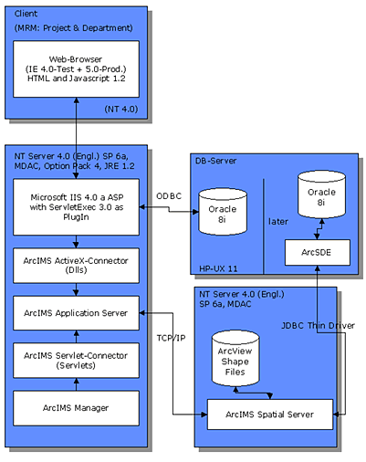
The basis of the intranet application is the internet mapserver ArcIMS 3.0. The software is installed on two servers – the application server (or webserver) and the spatial server (see Fig. 1). The NATHAN application has been realized entirely with ASP scripts for use with the MS Internet Explorers 4.0.
Figure 1: Architecture and components of NATHAN
NATHAN is divided into 3 subcomponents - Worldmap, Country Profiles and Catastrophe Catalogue. An example in Section 3 helps to understand how the three modules work.
NATHAN offers specific information and service any time and anywhere. The main benefits for users of NATHAN are:
In the following, we will use a typical example from the insurance industry – specifically an underwriter's investigation of an insured object– to show how NATHAN can be used. (Within the framework of this paper we will only be able to deal with a small fragment of the wide range of functions available).
Example
Request: Natural hazards cover for a semiconductor factory in Taiwan, about 60 km south of Taipei
The Country Profile module first gives a statistical overview of the geography, population and economic strength of the country, and the natural hazards the country is exposed to as a whole.
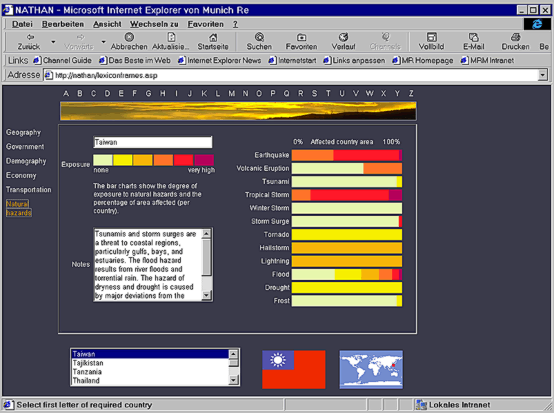
Figure 2: Country Profile
The exposed areas are expressed as a percentage of the country's surface area. As the example shows, Taiwan is highly exposed to the hazards of earthquake and tropical storm (see Fig. 2).
Munich Re’s Geoscience Research Group has been systematically gathering information on natural events and catastrophes throughout the world for more than 25 years (MRNatCatSERVICE). In addition to the basic data such as event location, date and duration, short descriptions with relevant information giving a quick overview of the magnitude of the events have also been compiled. If appropriate information is available, damage to or destruction of buildings, the effect on infrastructure, damage to utilities and agriculture, etc. are noted. The effect on the population (fatalities, injured, homeless, missing persons, etc.) is also listed. Finally, the economic and insured losses are recorded. This data is crucial for analysing and determining trends.
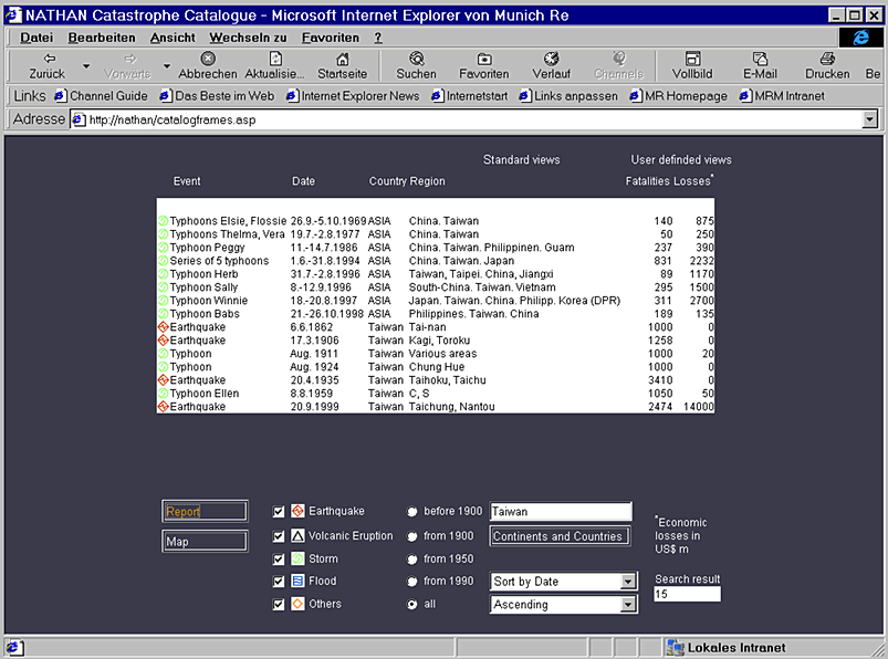
Figure 3: Extract from the catastrophe catalogue for Taiwan
This permits a rough regional estimate of the frequency and intensity of natural catastrophes on a country-by-country basis. The events are listed by types, country, date or amount of losses (see Fig. 3).
In addition to standard inquiries, the user can also formulate interactive inquiries on events, durations, countries and regions and, if desired, compile and print out these queries in table or map form (all loss events are geocoded, see Fig. 4).
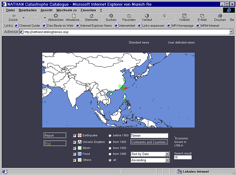
Figure 4: Map of historical events in Taiwan
The exact spatial distribution of natural hazards and of their intensities is best viewed in the World Map module. In our example the user locates Taiwan as the target area using the navigating tool and zooms in. The various hazard themes can be selected and displayed one by one. Cities, borders, waterways and a latitude/longitude grid can also be activated for better orientation within the map. The risk location can be pinpointed exactly using a list of places (including all cities with a population of more than 100,000).
Another possibility to identify a risk location is provided by the interactive Distance Function (see Fig. 5), which enables the user to measure the distance between two locations. In our example we measure a distance of some 60 km south of Taipei.
Finally, the high-powered Hazard Pointer may then be used to make a qualitative risk assessment (see Fig. 5). The Hazard Pointer is the most powerful tool in the NATHAN application for the purpose of obtaining a very quick overview of natural hazards. Of course, people may be better informed of the hazards at their own location, but NATHAN supplies information on the situation at every point on earth (would you, for example, know the hazard situation in Ulan-Bator?).
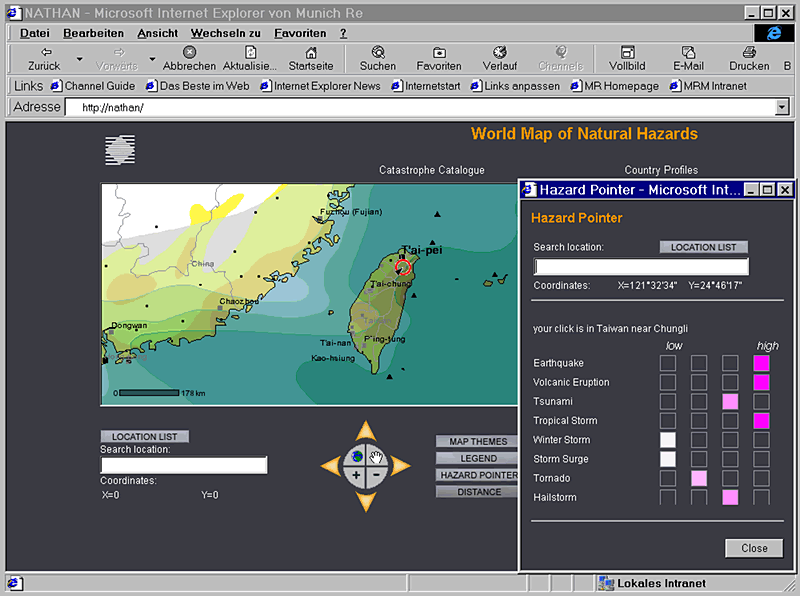
Figure 5: Identification of the natural hazard situation at any point on earth
As the example shows, the selected location (60 km south of Taipei) is highly exposed to the hazards of earthquake, tropical storm and volcanic eruption (see Fig. 5).
In the example chosen, there are other hazards of significance in addition to those mentioned above, namely hailstorm and tornado. Tsunami and storm surge have to be considered in the vicinity of the coast only.
If more detailed explanations are needed on any of the hazards, push the legend button. The legend has three essential components for the main hazards – intensity, frequency and reference period.
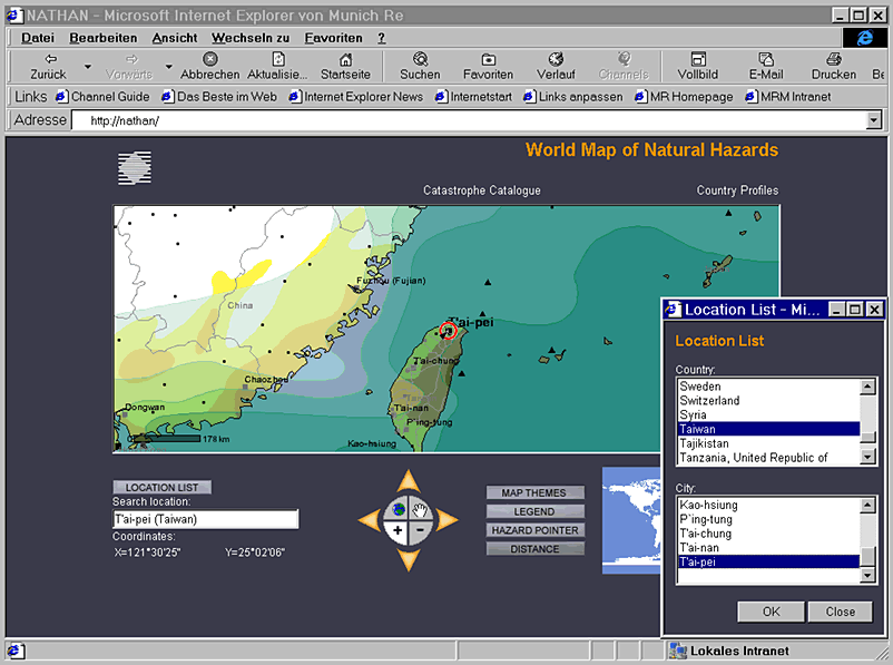
Figure 6: Worldmap with a comprehensive list of locations
The extensive location list is a very user-friendly feature when searching for a specific risk location. Users can either enter a search object directly (e.g. the name of a town) or preselect a country from a list (Location List) and then click on the target sought. Using the Distance Function it is then possible to determine any risk location from a given point (see Fig. 5).
The "prospective underwriting" approach in the insurance industry is increasingly being supplemented by a spatial or geographical component, "geographical underwriting". This kind of observation has many advantages and strengths. The following reasons may be cited:
In the insurance industry a large proportion of the data used and needed has a "geographical component", which is the prerequisite for the analyses and models mentioned at the beginning.
The quality of the results depends to a significant extent on the spatial resolution, i.e. the degree of detail of the information used. Here, improvements are to be expected, especially in terms of insurance-related information. This means, for instance, that in the future it will be possible to use an postal address to georeference clients and policies that are nowadays amalgamated in larger spatial units (postal code zones, administrative areas). Some companies are already using this method successfully, especially in the United States. The beginnings can be seen in Europe too, although each country has its own laws on data protection that have to be considered. Matching individual addresses within a group of buildings is a conceivable solution.
Important input for the insurance industry will be supplied by new and also time-saving techniques such as remote sensing and GPS (Global Positioning System). The precise definition of positions using GPS is an economical and efficient process because the system is accessible 24 hours a day and only requires the use of a user-friendly receiver the size of a mobile phone. The accuracy that can be attained is between 5 and 10 m, which is sufficient for the majority of applications. Once the coordinates have been recorded, they can be linked up with descriptive information and then fed into the main system. Possible areas of use include the documentation of individual risks during risk inspections (supported by photos and videos, if required) and the assessment of damaged objects after catastrophe events for expert reports.
In order to support risk management with even more comprehensive information it is necessary to develop NATHAN in the direction of a genuine rating tool. This means that the hazard information currently available must be supplemented by underwriting parameters. The first step is to incorporate additional information that is needed to determine the technical rates for different lines of business (e.g. residential, medium industrial risk). The aspect of occurrence probabilities must also be taken into account at this stage of the process.
The techniques portrayed in this paper will contribute to optimizing risk management in the future. The fact that some 85% of all information used in the insurance industry has a spatial relation means that "geographical" underwriting will become increasingly important. It facilitates not only transparent management and underwriting decisions but also allows an intensive transfer of expertise and knowledge between all parties concerned with the "insurance object globe".
For a complete list of references and sources used see World Map of Natural Hazards, cited below
Munich Reinsurance Company: World Map of Natural Hazards, 3rd edition, Munich, 1998.
Munich Reinsurance Company: CD-ROM "World of Natural Hazards", 1st edition, Munich, 2000.
Berz, G. et al.: World Map of Natural Hazards – A Global View of Distribution and Intensity of Significant Exposures; Natural Hazards 23, pp. 443-465, Kluwer Academic Publishers, Netherlands, 2001.
Dr. Juergen Schimetschek
Expert for Natural Perils
Geoscience Research Group
Munich Reinsurance Company
D-80791 Munich, Germany
E-mail: JSchimetschek@munichre.com
URL: http://www.MunichRe.com
Tel: +49 89 3891-5033
Fax: +49 89 3891-75033