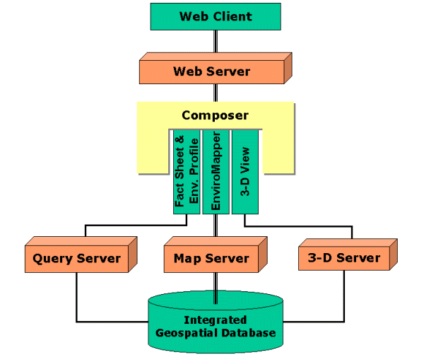
Figure 1. WME Architecture.
On January 5, 2001, the Environmental Protection Agency (EPA) introduced "Window to My Environment" to the public. Window to My Environment (WME) is a web-based application that allows the public to view detailed information on air and water quality, watershed health, toxic releases, contaminated site clean-ups, and state and local governmental services in their neighborhood or place of choice anywhere in the mid-Atlantic region, including Delaware, District of Columbia, Maryland, Pennsylvania, Virginia, and West Virginia. It is geography centric--users can enter a ZIP code or city/town name and state, and WME will zoom in to the user-specified geographic area and produces a single web page containing an interactive web-based mapper, a fact sheet and an environmental profile. Users can also navigate with the interactive mapper or change the display by choosing their layers of interest from the layer list. When the geographic window is changed (i.e., increased, shifted or decreased), the fact sheet and the environmental profile will be updated accordingly. All local environmental information is retrieved from EPA's Envirofacts Data Warehouse and other federal, state, and local web services. WME can be accessed from EPA's homepage (http://www.epa.gov) under "Your Community."
WME was developed through integration of cutting-edge technology. The interactive mapper was developed using ArcIMS with ActiveX connector, and a frameless HyperText Markup Language (HTML) interface was developed using dynamic HTML and JavaScript. The WME interface also includes a dynamic and intelligent map legend that is both collapsible and expandable, so that a longer legend can be handled properly without overwhelming the web page. Available Geographic Information System (GIS) functions were described as simply as possible, making the interface as intuitive as any web page. The fact sheet and the environmental profile were developed using Oracle Spatial and Oracle's PL/SQL and are served through an Oracle Application Server. All WME components communicate each other using HyperText Transfer Protocol (HTTP) and are recomposed via Cold Fusion as a single web page for the public. All data used to render maps are stored in ArcSDE; the data supporting the fact sheet and environmental profile are stored in Oracle.
For the past several years, EPA has provided public access to environmental information through the World Wide Web believing that it is one of the best ways to protect public health and to safeguard the environment. This environmental information addresses air pollution, ozone maps, public drinking water system, discharges to water, solid waste, human health, etc. In particular, EPA built the Envirofacts Warehouse to provide the public with direct access to the wealth of information contained in its databases. The Envirofacts Warehouse allows the public to retrieve environmental information from EPA databases on Air, Chemicals, Facility Information, Grants/Funding, Hazardous Waste, Risk Management Plans, Superfund, Toxic Releases, and Water Permits, Drinking Water, Drinking Water Contaminant Occurrence, and Drinking Water Microbial and Disinfection Byproduct Information. Envirofacts was also spatially enabled to provide point-source locational information, and a multi-award winning tool, EnviroMapper, was developed to help the public view this environmental information. Today, EPA provides greater access to more environmental information than ever.
Information is especially important because the environmental challenges of the new century cannot be solved by EPA acting on its own at just the federal level. States, local governments, businesses, and in many areas, communities and individual input will be essential in order to provide a comprehensive national picture of the country's environmental health. EPA recognizes that the rapid, sweeping and profound information technology advancement creates significant pressure to conduct business differently and creates an emerging need for more and better information and, consequently, new information management capabilities.
In 2000, EPA announced a new initiative called the "Information Integration Initiative." The initiative was EPA's fundamentally new approach to integrate, manage, and provide access to environmental information that uniquely recognizes the strategic significance of their state partners and other data providers in their ability to succeed. "Window to My Environment (WME)" was one of the projects designed under the initiative. WME is a powerful web portal that allows the public to "see" detailed information on air and water quality, watershed health, toxic releases, contaminated site clean-ups, and state and local governmental services for their neighborhood or place of choice. The immediate available area covers Delaware, District of Columbia, Maryland, Pennsylvania, Virginia, and West Virginia.
WME is a hybrid web-based application that integrates web-based GIS with complex database queries. The web-based GIS is composed of the well-known EPA EnviroMapper map engine and OpenLink, which is a web GIS service that produces map images in real time. Those complex queries consist of a series of Envirofacts queries, a reporting module of Ultra Violet (UV) index, and a community environmental fact sheet. The map engine and OpenLink were developed using ArcIMS 3.0 with an ActiveX connector. All queries, the UV module and the fact sheet are Oracle stored procedures. The GIS module is served through Microsoft Internet Information Server (IIS), while the Oracle modules are offered as a web service via Oracle Application Server (OAS). In addition, there is a 3-D data visualization module that drapes the US Geological Survey (USGS) National Land Cover Data (NLCD) set, also called Multi-Resolution Land Characterization (MRLC), over the National Elevation Data (NED) set. All of these modules serve as web services and are composed together with Cold Fusion.
WME is a multi-tier web-based application consisting of presentation, business logic, and data storage tiers (Figure 1). The presentation tier includes the WME graphic user interface (GUI) for users to access, view, and analyze environmental data for the neighborhood of interest. The business logic tier is composed of web servers, converter, composer, map server, and query server. The data storage tier is a newly built EPA Integrated Geospatial Database (IGD), with all data sources available for use with WME.
Unlike the technology behind Esri's MapObjects Internet Map Server, predecessor of ArcIMS, ArcIMS has a spatial server component that provides functional capabilities such as rendering color, visibility, and scale dependency. The spatial server is composed of several servers that provide services of images, vectors, queries, geocoding, and data extraction. Services are set up using ArcIMS Author, a component of ArcIMS management tool. Therefore, there is less need to handle things such as color and scale dependency inside a map engine. Since communication between components within ArcIMS is handled through ArcXML, an implementation of eXtensible Markup Language (XML) used with ArcIMS, a connector such as Active Server Page (ASP) is needed to translate an HTML form request to an ArcXML request, or vise versa, to ArcIMS Application Server. WME's map engine was developed based on the ArcIMS ASP Connector.
The IGD (in Oracle) is a collection of geospatial data, tools, and information resources designed to provide a comprehensive inventory to support EPA in its next-generation GIS mission goals. It is comprised of Esri ArcSDE and Oracle Spatial geospatial data layers, Oracle stored procedures, and an index of available geoservice Universal Resource Locators (URLs). The ArcSDE data layers are stored in a binary format while the Oracle Spatial data layers are stored as normalized Oracle tables. The ArcSDE layers are used in WME for the map display. The Oracle Spatial layers enable spatial queries that provide statistics such as population density, county/urban area designations, and local watersheds/waterbodies in a user defined area. All queries are built as stored procedures. The IGD also consists of a table with URLs of web sites that offer relevant environmental information.
The IGD includes many geospatial data layers from various data sources including:
As stated previously, WME is built to provide the public with environmental health information. Considering the majority of the public still connects to the Internet through their phone lines, a quick-response service is necessary. ArcIMS offers two types of prime services image service and feature service. With an image service, which is served by an image server, a new map image is generated each time for a client request. A feature service uses a feature server and publishes compressed vector data back to a client. Feature services require a greater bandwidth than image services. WME uses two image services to meet the rapid-response need of the public, one for the main map and the other for the overview map. The main map service includes all feature layers in the integrated geo-database, while the locator map service only consists of state and county boundaries nationwide. All layers in the main map service were turned off by default, and a rendering of an individual map layer is triggered by the map engine.
WME uses the ActiveX Connector to connect the Microsoft Internet Information Server (IIS) to the ArcIMS Application Server. The ActiveX Connector is a Common Object Model (COM) Dynamic Linking Library (DLL) that can be used in web applications of ASP. The WME map engine was developed using ASP to provide mapping functionality such as zooming, panning, and feature identification. All requests are handled on the server-side, which offers two advantages. The page that is generated is a very thin client that is cross-browser complaint. Also, because the processing is on the server-side, the ASP code is not exposed to the web page and the user. Another benefit of the ASP solution is that WME can reuse some COM and DLL created for EnviroMapper, which was developed using Visual Basic based on MapObjects and MapObjects Internet Map Server. For example, WME was able to use EnviroMapper's intelligent legend and make the legend of the WME map engine dynamic as well as intelligent (see next section for detailed description).
WME uses a combined fact sheet and environmental profile approach to provide the public more detailed information. The fact sheet labeled "Your Window" in WME is produced by Oracle stored procedures to display statistics such as municipality, population estimation, congressional information and EPA-regulated facilities. A window is overlaid using Oracle Spatial, a geospatial component for the Oracle database, with cities and towns, county boundaries, ZIP codes, census block groups, hydrographic features, congressional district boundaries, urban areas, and EPA-regulated facility sites. The resultant statistics and associated hyperlinks to the sources, if any exists, are tabulated with a PL/SQL routine to form "Your Window."
The environmental profile labeled "Your Environment" employs Oracle Spatial and PL/SQL routines to mine respective links (URLs) from an Index of Geoservices stored in IGD for the current window. These links represent varying levels of federal, state, and local geography. A number of questions (topics) are provided under "Your Environment" that address a variety of environmental concerns, and each link is categorized to appear under a specific topic. Also associated with each link is the respective geospatial entity (e.g., a single county or watershed) or entities (e.g., all counties in a particular state). When a window overlaps the representative geospatial entity, the links become available and are categorized under the appropriate question. As the window is resized or moved (via zoom-in, zoom-out or pan), both the fact sheet and the environmental profile will be updated accordingly.
The 3-D View component of WME was developed at the EPA Scientific Visualization Center located in Research Triangle Park, North Carolina using the IBM Open Visualization Data Explorer (also called OpenDX). OpenDX is an application and development software package for visualizing data, especially 3-D data from simulations or acquired from observations. The 3-D View component was written in C language based on OpenDX's C Application Program Interface (API). It is served through a standard Common Gate Interface (CGI) on a web server to produce 3-D images.
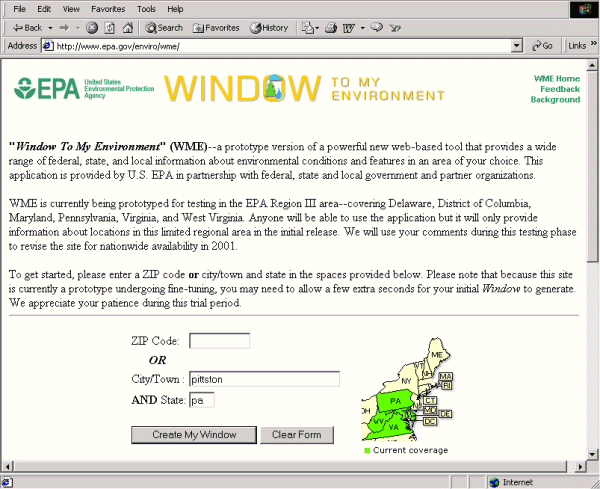
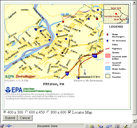
WME allows users to view their neighborhood or other place of choice. This area can be specified though a ZIP code or city/town and the corresponding state (Figure 2). WME can be accessed through the "Your Community" menu on the EPA homepage, located at http://www.epa.gov. Based on the user's specifications, a geographic window of approximately six miles east-west and five miles north-south around the area will be generated, as shown in Figure 3.
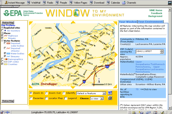
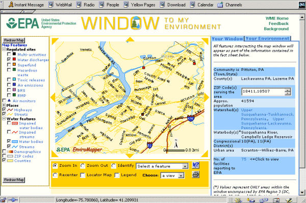
On the left side is a typical desktop-GIS look-and-feel map interface; on the right, two blue tabs labeled as "Your Window" and "Your Environment" are shown with "Your Window" displayed on top. Within the map interface area, a dynamic and intelligent legend is displayed. The dynamic mechanism of the legend is provided via its expandable/collapsible feature. For example, in order to display "Water Dischargers" in the map area, users can click on the plus sign in front of the "Regulated sites" category. The dynamic legend for that category will be expanded, and all available Envirofacts facilities including Multi-activities, Water Dischargers, Superfund, Hazardous Waste, Toxic Releases, Air Emissions, Biennial Reporting System (BRS), and Risk Management Plans (RMP) will be listed in the legend (Figure 4). Click on the checkbox in front of "Water Dischargers," and then click on the "Redraw Map" button. The map will then be updated with "Water Dischargers" displayed in red squares.
The dynamic legend solution made it possible to display each legend without scrolling down within a browser window, which has always been a challenge for web-based mapping application. Otherwise, another non-Java alternative would be to use a dedicated HTML frame window for the legend. However, HTML frames cause inconvenience to allow users to go back a true previous page because each frame is logged as a "previous" page in a web browser. When a user clicks on "Back" button, the application will revert to the previous frame window instead of a genuine previous page. The frame-window solution would also increase the complexity of WME GUI design and provide inconvenience to log web statistics.
The legend is also intelligently linked source-metadata home pages. For example, "Water Dischargers" is linked to EPA's Envirofacts metadata page, while "Highways" is linked to the Bureau of Transportation Statistics (BTS) at the Department of Transportation (DOT) metadata web page. In summary, the WME dynamic and intelligent legend include layer-control check box, symbology, description, and metadata hyperlinks.
The main map window is located in the center of the WME interface. It includes eight arrow buttons to provide panning features. For example, one can directly click on the arrow on top of the map to pan the entire map to the north. "Recenter" is also offered in the control panel (in orange) located underneath the main map to recenter the map based on user specification. In addition, functions including Zoom In, Zoom Out, Identify, Locator Map, Legend, 3-D View, Online Help, and PrintMap are available from the same control panel. All available GIS functions are spelled out for the user, and icons are used for the Online Help and PrintMap. By clicking on "Locator Map" check box, users can display an overview map to show the current working map window relative to a larger geographic area such as a state region. The overview map is displayed in the upper-left corner of the main map window. If a user clicks on "Legend" check box, a static map legend will replace the dynamic legend in display, and only displays those layers that are currently shown in the map. Clicking on the "Legend" check box again will bring back the dynamic legend.
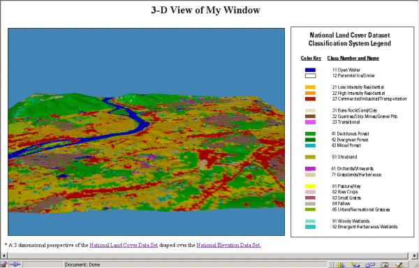
Another unique feature, 3-D View, is also offered in WME. A subset of MRLC data is extracted for the community depicted in the map and is draped over on to the NED. This produces an image with a 3-D perspective view of that community. A full descriptive legend is displayed side-by-side with the 3-D view image in the popup window (Figure 5).
Although WME is simply a portal site, it contains a complete set of online help, documenting every function and feature offered in HTML format. Every step is illustrated with a screenshot, and users can "jump" around within the online help page. A printable version of the WME map is offered via the "PrintMap" icon. A map with a title, static legend, north arrow, time stamp, and disclaimer is produced by clicking the "PrintMap" icon button (Figure 6). Users can enter their own map title or select from three different map resolutions.
Fact sheet and detailed statistics and reports on environmental conditions and trends for the identified community are available through "Your Window" and "Your Environment." "Your Window" presents a fact sheet of the community that is being mapped, which includes municipality, ZIP code, population estimation, local watersheds/waterbodies, congressional district(s) and the number of EPA-regulated facilities within/near the community. Statistics and reports are available through "Your Environment." Users can find out today's UV index in the area where they live or the drinking water quality. A variety of environmental information through federal, state, and local sources can be found from a variety of web sites via WME.
WME will expand its coverage area from the initial mid-Atlantic states to nationwide within the next twelve months so that it will become a national portal that provides the public with important and relevant environmental information about the places where they live, work, and play. Every concerned citizen can learn more about environmental health in their own neighborhood.
Technically, WME will start accessing other data sources directly using XML on the Internet and integrate them with the IGD on the fly. Information such as USGS ground water levels and water quality data would be complementary to environmental health if they were added to WME. WME will also try to incorporate other rendered map services directly to overlay. Sources such as ESIR GeographyNetwork.com and USGS NationalAtlas.gov would be good candidates.
One of best ways to locate a community is by a street address; but that requires a geocoding engine to convert the address to a latitude/longitude coordinate. Geographic Data Technology, Inc. (GDT) located in Lebanon, NH offers a web-based geocoding application called "Map Your Address!" on its homepage. It is very good and provides a result within an acceptable accuracy. "Map Your Address!" would be a good candidate for web-based geocoding.
The authors gratefully acknowledge Marcy Brizzolara for her review and Randall Hopper, author of the 3-D View component, from Lockheed Martin at the EPA Scientific Visualization Center, Research Triangle Park, North Carolina. This work was supported by the EPA Office of Environmental Information (OEI) Mission Oriented Systems Engineering Support (MOSES) contract under the Information Integration Initiative and the Envirofacts Information Warehouse Initiative.
Vincent Zhuang
Science Applications International Corporation
6565 Arlington Blvd.
Fall Church, VA 22042
Xiaowen Huang
Science Applications International Corporation
6565 Arlington Blvd.
Fall Church, VA 22042
John Sun
Science Applications International Corporation
6565 Arlington Blvd.
Fall Church, VA 22042
Matthew Moss
Science Applications International Corporation
6565 Arlington Blvd.
Fall Church, VA 22042
Adam Deer
Science Applications International Corporation
6565 Arlington Blvd.
Fall Church, VA 22042
Dalroy Ward
Science Applications International Corporation
6565 Arlington Blvd.
Fall Church, VA 22042
Yi Zhou
Indus Corporation
1953 Gallows Road, Suite 300
Vienna, VA 22182
Bryan McEnaney
Indus Corporation
1953 Gallows Road, Suite 300
Vienna, VA 22182
Dave Wolf
Environmental Protection Agency
401 M Street, SW
Washington, D.C. 20460