1. INTRODUCTION:
This paper is an environmental impact analysis for the catchment and command areas due to the construction of a dam on the Man River in the states of Gujarat and Maharashtra in India.
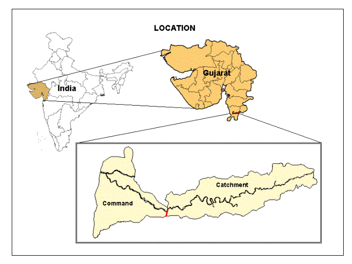
The dam is proposed to be located on the Man river in the Sidhumber village in Gujarat, India. This dam shall impound gross storage of 174,430 cubic meters of water and is expected to irrigate 15170 hectares of land.
The study attempts to assess the present problems of the area and to provide suggestive measures for the watershed improvement of the Man River after the construction of the dam. Various information layers were integrated through the GIS software Arc/Info using overlay methods. Suitable site selection for different types of treatments, using the criteria rules of Arc/Info has also been performed.
2. OBJECTIVE OF THE STUDY:
This region of Gujarat, India is backward and underdeveloped. The irrigation potential is heavily underutilized, with only one Daman Ganga reservoir project. This study shall prepare a detailed environmental impact analysis of the proposed dam and environmental management plan in the catchment and the command areas of the Man River for clearance by the Ministry of Environment.
The watershed of the Man River has a semi-arid climate. The scarcity of water is acute. In spite of having a rich black cotton soil, the area is backward because of dependency on rain fed agriculture. The increased irrigation potential due to the proposed dam shall have a great impact on the socio-economic upliftment of the region.
The construction of the dam is aimed at improving the land productivity in the command area. Proper utilization of the irrigation water from the dam is suggested to prevent increase in the land salinity in the command area. The study shall assess the status of erosion and land degradation in the catchment area to prevent siltation and to suggest the future plan of treatment.
3. STUDY AREA:
The Man River originates in the Nasik district of Maharashtra, India and flows through Valsad district of Gujarat, India and discharges directly into the Arabian Sea. The area is located between 73o 15’ - 73o36’ E longitude and 20o 25’ - 20o 40’ N latitude, and covers parts of the Survey of India topographic sheet numbers 73H/2,3,6,10. The catchment area is demarcated into sub-watersheds and consists of 55 villages covering an area of 261.0 sq.km. The command area covers an area of 192.6 sq.km. consisting of 37 villages.
4. METHODOLOGY:
The following tasks have been undertaken to meet the study objectives
- Generate thematic maps of various natural resources
- Integrate the thematic maps
- Define the plan of implementation
The use of satellite data in recent years has gained much importance for natural resource mapping. This study is carried out by combining the features of satellite imagery, topographic sheets and secondary maps data to produce the necessary information layers of natural resources
The input data from all of the above diverse sources are translated into the thematic maps by the methods of:
- interpretation,
- classification,
- manipulation,
- integration,
- editing and
- analysis
The data translation into thematic maps employed the GIS software Arc/Info and Arc View and the remote sensing software ERDAS. The multi layer thematic maps generated necessary information to provide detail insight to suggest the necessary improvement of the command and catchment areas.
During the last few decades GIS software has gained importance for generating overlays and making site-specific decisions. Multi-spectral remotely sensed satellite data plays a vital role in the generation of the overlays.
Manual integration of the entire surface and sub-surface information, requires huge expenditure of manpower and time. Working on the GIS platform is faster, more accurate and therefore cost-effective. The integration of the satellite imagery and GIS has eased the data integration and analysis of very large data sets. The database (both spatial and non-spatial) is imported and created or generated in Arc/Info. The required non-spatial database is attached to the respective coverage.
The GIS package Arc/Info is extensively used, especially the Triangulation Irregular Network (TIN), GRID, various overlay methods, etc. Logical expressions are used to select the treatment areas in the command and the catchment areas. Based on the criteria selection analysis in Arc/Info various types of treatment needs have been suggested.
5. GENERAL DESCRIPTION OF THE AREA:
The Man river catchment zone has been analyzed by dividing it into the catchment and the command area of the reservoir for the proposed dam. This division has been done because the treatment type for both areas is different. The catchment area covers the Dharampur taluka of the Valsad district in Gujarat and the Nasik district in Maharashtra. The command area covers the Valsad, Chikli and Dharampur districts in Gujarat, India.
These information overlays of natural resources are generated from the Survey of India topographic sheets and satellite imageries, populated by ground truth.
5.1 Physiography and drainage:
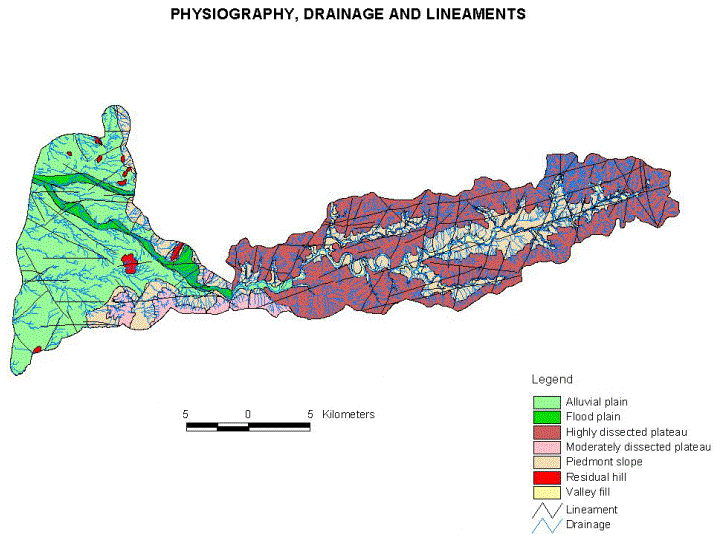
The catchment area of the proposed dam consists of flat topped, highly dissected plateaus and dyke ridges running in a west to east direction.The Man River in the catchment area flows in incised meanders forming steep ‘V’ shaped valleys with steep sides. The entire catchment has a rectangular and trellis pattern of drainage depicting the influence of the structures on the drainage development. The piedmonts at the base of the steep plateaus and dyke ridges are covered with thin soils, which supports agriculture in very few areas. The river valley, wherever flat, has good quality soil and is mostly cultivated based on the availability of water. The valley fills with thick alluvium provides the only area for cultivation.
The command area of the proposed dam is surrounded by moderately dissected plateaus and piedmont slopes. The slope of the land along the piedmont and the nature of flow of the streams (e.g. in the upper part of the command area near the village Panikhadak) provide ample proof of scarp retreat. The rivers in the piedmont slope area show parallel pattern, which are partly controlled by the lineaments. Along the river valley the flood plain consists of good quality soil, suitable for cultivation.
The largest portion of the command area is the alluvial plain, which has been formed by the river Man. The alluvial plain is studded with number of residual hills with degraded forests. The river Man in the command area also flows in straight channels, which shows that the river is structurally controlled .
5.2 Geology and structure:
The catchment and command areas are occupied by various Deccan trap lava flows viz. Amygdaloidal basalt and Porphyritic basalt and agglomerate of the Cretaceous – Eocene age. These are traversed by dolerite dykes. Except in the river bed the rock is highly weathered and exhibits spheroidal weathering.
Big cavities filled with secondary quartz are also seen. The agglomerates separate the lava flows and occur in the form of lenses of thickness varying from 1-2m.
Top of the plateaus consists of porphyritic amygdaloidal basalt, which is highly fractured and jointed. The joint patterns as recorded in the rocks show a W-SW – E-SE and W-NW – E-NE direction (Figure-2).
5.3 Climate:
The area has a semi-arid type of climate. It records a maximum temperature of 42oc with a mean annual temperature of 27oc.April and May are the hottest months. In winter the temperature drops to 7oc. January is the coldest month.
About 95% of the rainfall comes from the South-West monsoon. The average annual rainfall is 2465mm is concentrated in a few months and the remainder of the year is dry.
5.4 Soil series:
The area, being of basaltic formation, falls under the broad soil group of red loams and black clayey soils. The transmission of water through similar parent material seems to have influenced the development of different physiographic characteristics of the soils in the area.
Below is given a brief description of the physiographic characteristics of the soils of the area
.
Soils of the high lands: The characteristics of the dissected plateau with a slope above 8o have gravelly, shallow to moderate thickness, loamy, non-calcareous soil, which has eroded and derived from intra-trappean basalt rock in situ condition.
The area in between the hills with sloping lands, contains dark yellowish brown to very dark grayish brown gravelly clay loam to clayey soils of shallow to moderate thickness.
The dissected hill and steep slopes suffer from severe erosion hazards. The steep hill slopes are almost devoid of soil. These are marked as miscellaneous land type with Billimoda-Bedmal soil association, having very poor and sparse forest growth.
Soils of piedmont slopes and river valleys: The relief decreases towards the west and the materials washed out from the upper reaches are deposited in the downstream areas. The area is usually having 3-5% slope gradients. The soils in these area are of shallow to moderate thickness, dark reddish brown to very dark grayish brown, clay loam to clayey, non-calcareous of the Kanjod-Baldha and Vadwania-Baldha soil series associations.
Soils of the alluvial plain and flood plain: The piedmont slope gradually merges into the alluvial plains with gently sloping land. The soil becomes deep to very deep, clayey calcareous and non-calcareous, dark grayish brown, very dark grayish brown to dark yellowish. The soil cracks vertically during dry season due to montmorillnitic type of clay. Jalalpur and Sisodra soil series occur on this physiographic unit.
The flood plain consists of moderately deep to very deep alluvial soils. The soil series identified are Gadat-Sisodra. They are deep soil formed by river weathering of basaltic parent material. Gadat is reddish brown to dark reddish brown, silty clay loam to clay loam, non-calcareous soil. Sisodra is moderately drained, dark brown to brown soils, formed by alluvium.
5.5 Land use/ Land cover:
Digital interpretation of IRS LISS-III FCC on 1:50,000scale for two season dates is done in ERDAS for identification of different land use land cover classes based on the image characteristics. The multidate imagery are interpreted for the details of the crop land in the two harvest seasons known as the kharif and Rabi seasons. Based on ground truth verification the boundaries are finalized which synchronizes well with the physiography, slope and soil of the area. Twelve land use / land cover classes have been identified in the command area and eight classes have been identified in the catchment area
.
As a result of the proposed dam, 5 sq. km of forest area and 7 sq. km. of kharif land are growing into submergence. Remainder of the total submergence area of 17.6 sq. km. is mainly wasteland.
6. PREPARATION OF THE SECONDARY OVERLAYS
The secondary layers are derived from the above datasets in Arc/Info by the various overlay functions. Polygons below a threshold limit eliminated to generate the final layers based on which the decisions can be made.
6.1 Slope:
The slope map is derived by using the GRID and TIN features of Arc/Info. The input data are the contours from the Survey of India topographic sheets. After converting from raster to vector layer it is processed for generating the secondary overlays.
In the catchment area, the plateau tops have slopes of 0-3% and the steep hillsides are above 8%. The piedmonts comprise of slopes mainly between 5 – 8%. In the river bed and the valley fills, the slope remains below 5%.
The command area, comprising mainly of the alluvial plain and the flood plain, has a slope ranging between 0-3%. In the surrounding dissected plateau and piedmont, the slope varies between 3 – 8%.
7. GENERATION OF FINAL OVERLAYS FOR DECISION MAKING
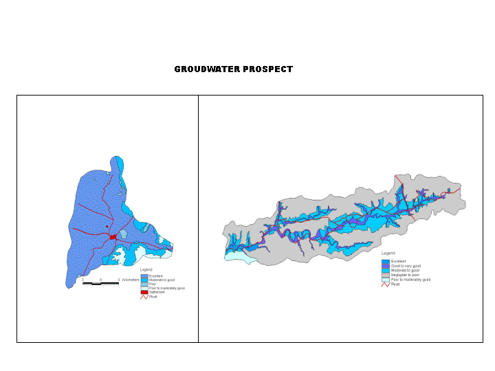
7.1 Hydrogeomorphology and groundwater:
The hydrogeomorphological map is prepared by overlaying geomorphology, lithostratigraphy, structure and land use. The hydrogeomorphologic conditions for each landform type are identified based on the above layers. Groundwater prospects are assigned to each unit. A total of five classes of groundwater prospect areas have been identified in the catchment area. The groundwater status in most of the area varies between poor to moderate, especially in the dissected plateaus and dyke ridges. Good groundwater prospect exists in few places in the flood plain near the Sidhumber reservoir area, along the lineaments and in the weathered zones
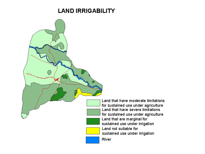
7.2 Land-Irrigability:
In the command area, based on the texture, structure, permeability, of the soil, soil-irrigability classes are assigned and each type of soil irrigability class is given a unique code. This soil-irrigability layer is unionized with the slope layer to derive the land-irrigability classes. Based on the percent slope and soil irrigability classes, four land-irrigability classes have been identified .
7.3 Composite Erosion Intensity Units/Composite Land Development Sites:
Overlaying of the slope, soil and land use, in Arc/Info for both the catchment and command areas, has generated the Composite Erosion Intensity Units (CEIU)/Composite Land Development Units (CLDU) respectively. Total 47 unique CEIU and 42 unique CLDU have been generated for the catchment and the command areas respectively.
The area of each unique CEIU is estimated for each sub-watershed. These CEIU/CLDU have been used for decision making.
7.4 Land Capability:
Overlaying the slope, soil, land use and environmental factors of each CEIU/CLDU, land capability classes are generated. Each land capability class is identified by a unique characteristic, having similar hazards of the soil to various factors, which causes soil damage, decreases soil fertility, and its potential for agriculture.
In the command area the land-capability has been assigned for the development of the area. In the catchment area land capability has been assigned for future treatment.
.
7.5.Sediment Yield Index:
Based on the characteristics of the 47 units of CEIU, each CEIU are assigned weightage and delivery ratio. The Sediment Yield Index is assigned to each CEIU. The sub-watersheds have been identified based on the area eroding more in time and space and have been prioritized based on the Sediment Yield for future treatment.
.
8. TREATMENT PLANS :
The treatment plans have been customized based on the composite final overlays for the Sidhumber Dam on the Man River.
8.1 Development plan for the command area:
Based on the land irrigability of the command area, it has been found that around 176.8 sq.km. of the total command area of 192.6 sq. km or 91.8% is expected to produce better crop by irrigation water from the dam, provided proper drainage facilities are present.
The land capability also shows that approximately 170 sq.km. area of the command area has II and III land capability, which indicates that the area can produce better crops by improving the quality of soil with appropriate treatment of nutrients and fertilizer.
Based on the soil, land use, slope, land irrigability etc. of the command area, suggestions have been made to change the land use pattern and undertake reforestation in some of the areas.
8.2 Treatment plan for the catchment area:
The longevity of the proposed dam can be extended by checking soil erosion in the catchment area. After a detail assessment of the above overlays, it is recommended to treat each sub-watershed from different aspects.
Based on the Sediment Yield Index, the sub-watersheds were prioritized for treatment.
The land capability of the catchment area shows that 16.4 sq.km. of the total catchment area of 261.0 sq. km. can be treated with soil and water conservation methods to increase the moisture retention capacity, thus improving the fertility of the soil. Development measures for the command area have been suggested.
The drainage line treatment is also necessary in the catchment area to prevent soil erosion. The catchment area having diversified slope, soil and land use, the treatment suggestions carried out in three parts separately:
- For forest and watershed
- For agricultural land
- Drainage line treatment
The major drainage lines are assigned stream order and divided into upper, middle and lower reaches based on the slope of the terrain. The length of each drainage line in each type of land use is calculated. Different treatments based on the length of the drainage lines in the upper middle and lower reaches, in each type of land use, different soil conservation measures have been recommended.
CONCLUSION
The entire study was carried out by using, Arc/info, ArcVIEW and ERDAS. The intricate overlays, which are manually impossible to generate, along with the detailed calculation have been successfully performed. Geosoft Topographics (GTIPL) has successfully completed the study suggesting the treatments for the development of the command and the catchment areas, along with some preventive measures for reducing the soil erosion in the catchment.
Due to the construction of the dam on the Man River, an area of 17.55 sq.km is going under submergence. This area consists of parts of five villages. The villages which are most affected are Avdha, Rajpuri jungle and Hanmanthmal. The affected inhabitants can be suitably rehabilitated in the non-submerged part of the villages.
Work is being carried out for estimation of time and manpower for implementing the treatments in the command and catchment areas.
ACKNOWLEDGEMENTS