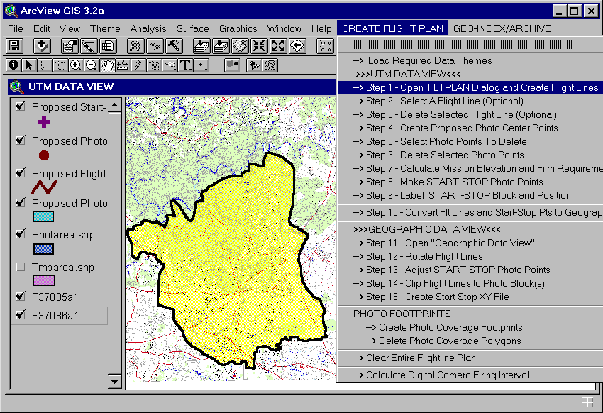
Figure 1.
U.S.D.A. Forest Service - Forest Health Protection personnel have long utilized aerial photography to delineate and map insect and disease concerns. High resolution digital scanning of aerial transparency photography has improved the utility of this older technology. Scanned transparencies have high spatial resolution and when combined with GIS, become a powerful tool for locating and analyzing forest insect and disease. In order to efficiently plan for aerial photography missions and effective use of scanned photography required the creation of the FLTPLAN ArcView application designed to automate the process of planning, analysis, and presentation using aerial photography. FLTPLAN has multiple capabilities including mission planning, geo-indexing, world file creation, photo scale calculation, mission archiving.
For three decades, U.S.D.A. Forest Service (USFS) Forest Health Protection (FHP) personnel have utilized aerial photography as a means of accurately mapping insect and disease concerns. Even as new technologies are developed, the interpretation of aerial photography remains a critical component of insect and disease monitoring. High resolution digital scanning of aerial negative transparency photography (CIR and Pan Color) has brought more utility the older technology. Scanned aerial photography has a very high degree of spatial resolution and a relatively low acquisition cost, and when used with GIS, becomes a powerful tool for mapping, analysis, and presentation of forest insect and disease. In regards to flight planning for aerial photography and/or digital imagery missions, the traditional method was to create flight plans by hand on paper maps with rulers and pencils. This method of flight planning was generally effective, however, it is time consuming, inconsistent, and error prone.
FLTPLAN, created by U.S.D.A. Forest Service Forest Health Technology Enterprise Team (FHTET), is an ArcView 3.2 application designed for all levels of ArcView user ability. It has multiple features for photo mission planning, analysis, geo-indexing, archiving, and presentation that create a high degree of planning consistency, accuracy, and speed. FLTPLAN spatially automates these processes creating world files to geo-reference scanned transparencies by calculating the photo scale of each scan and displaying the scanned photo and coverage "footprint" in the view window. The system also automates the flight mission planning process creating flight lines based on user-entered side lap, photo size, scale, and flight line direction, tallies the number photographs and film rolls required for the mission, and calculates overall ground elevation and aircraft flying height required for the desired photo scale. FLTPLAN uses contextual data sets that are easily obtained such as Digital Raster Graphics (DRG), Digital Ortho Quads (DOQ), and Digital Elevation Models (DEM).
Flight mission planning begins with the acquisition of DRG(s) and DEM(s) digital data for the flight mission area as well as a polygon theme that delineates the area to be photographed. These data and the internal FLTPLAN system themes are loaded into a view window (UTM Data View). Using these data, FLTPLAN leads the user through a series of steps to efficiently create an aerial photography or a digital imagery flight mission plan (figure 1). Flight lines are the most important component of mission planning because they are used to locate all potential photo center points which, in turn, are used to generate the start and stop coordinates. The aircraft pilot uses the start-stop coordinates to fly each flight line. The photographer also uses the start-stop coordinates to start, increment, and stop the film. FLTPLAN uses the photo center points to estimate the amount of film required as well as collecting elevation values from the DEM to calculate the average mission elevation and aircraft flying height (AGL - Above Ground Level) required to maintain photo scale.
Figure 1.
To create flight lines for the selected mission area polygon, the user opens the FLTPLAN dialog and selects the type of imagery, photo-line direction, film size, focal length, photo overlap, sidelap, and photo scale (figure 2). Clicking on the CREATE FLIGHT LINES button automatically creates flight lines, which can be seen in the view window (figure 3).
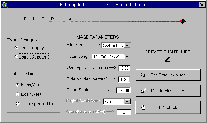
Figure 2.
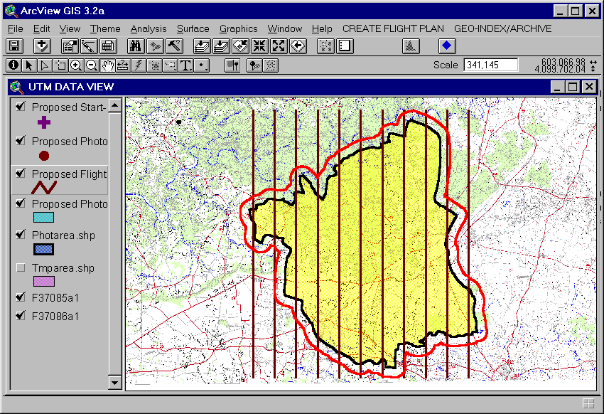
Figure 3.
FLTPLAN allows the user to experiment with different flight line layouts by selecting different distances from the mission area polygon extent boundary to start the flight lines. Flight lines for north-south missions start from the left most extent (minimum X coordinate) and flight line for east-west mission start at the top most extent (maximum Y coordinate). The user may start flight lines at the extent boundary itself or select from six other choices; i.e, 10%, 15%, 25%, 33%, 50%, or 75% the width of photo ground coverage. This feature allows the user to create the most cost-effective mission plan with a minimum number of flight lines. When the desired flight line plan is completed, the next step prompts the user to create the proposed photo center points that will fall along each flight line.
The distance between each photo center point is dependent on the scale and overlap that the user had entered with the Flight Line Builder dialog (refer to figure 2). FLTPLAN automatically creates these points and displays them in the view window. The photo center points will be located within the entire mission extent area. Given that a mission area is rectangular or square, the user may not need to delete any proposed photo center points. However, the more common mission area has a more free form shape that may follow landscape features (e.g., fire boundary, forest cover boundary, etc.) or that follow political boundaries that require the user to select and delete photo center points that are beyond the actual photo mission area (figure 4, top and bottom).
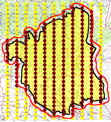
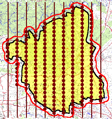
Figure 4.
After editing the photo center point theme, the user may then calculate the mission parameters including the average mission ground elevation, proposed number of photos, estimate of the number of film rolls (both 200 and 400 foot rolls), aircraft flying height above ground level to maintain the user-defined photo scale, and total length of flight lines (figure 5). FLTPLAN automatically samples the DEM at each proposed photo center point to calculate average mission elevation and the mission aircraft flying height is calculated using the average ground elevation and scale. These factors are essential to estimate time and cost of the mission.
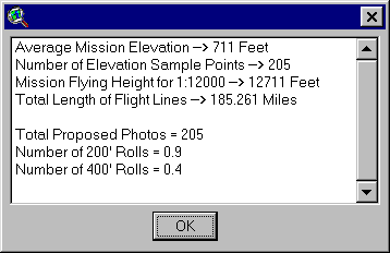
Figure 5.
Next, FLTPLAN prompts the user to create the start and stop coordinates for each flight line. From the proposed photo center points theme, the user selects the north and south most points (east and west most point if the flight line direction is east-west) and FLTPLAN automatically creates a new point theme containing only these points and displays them in the view window (figure 6).
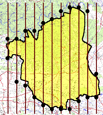
Figure 6.
Because the flight line theme, proposed photo center points theme, and the start-stop point theme were developed in the using the DRG data sets, they are in a UTM (Nad27) projection. However, the aircraft GPS unit requires the start-stop point coordinates be in the Geographic projection (degree-decimal minutes, Nad27). As a result, the start-stop points theme, flight line theme, and the mission area theme need to be reprojected. FLTPLAN prompts the user to use ArcView's Projection Utility Wizard extension to reproject these themes.
The reprojected themes are loaded into a separate view (Geographic Data View). Because of the reprojection from UTM to Geographic, the flight lines no longer have the same longitude coordinate at the start and end points of each line (for north-south flight line direction). However, the pilot needs to fly a single longitude coordinate as he flies along each flight line. As a result, the flight lines features need to be adjusted slightly. FLTPLAN allows the user to adjust the flight line by taking the longitude coordinate from the middle of each line and creating a new flight line features. The start-stop points are automatically adjusted over to the new flight lines ensuring the longitude coordinate is the same for each line's start-stop points (figure 7). During the adjustments to flight lines and start-stop points, FLTPLAN automatically creates a degree-decimal minute coordinate attribute in the start-stop point theme table. This is then used to label each start-stop point. The user can then add the DRGs into the Geographic Data View window and begin plotting the photo mission from a layout document at any user specified scale complete with graticules (Graticules and Measured Grid ArcView extension) at the appropriate scale and handed off to the pilot and photographer to use on the actual mission flight.
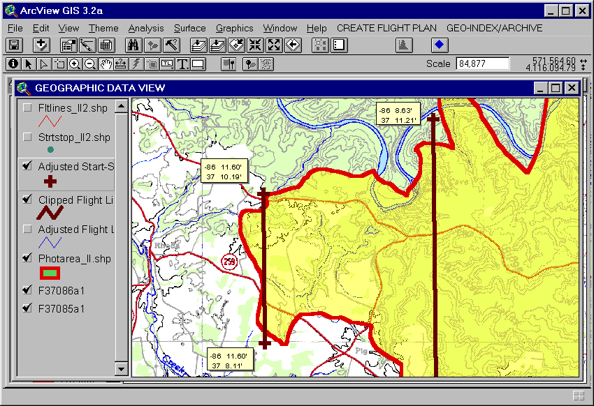
Figure 7.
Once a photo mission has been completed and the photography has been developed and delivered and scanned, the user can create an archived photo center points theme. Optimally, the archive mission photo center points would be located exactly on the proposed photo center points that were developed during flight mission planning. However, due to winds aloft and other weather conditions that affect the aircraft, the archive photo center point locations may differ (sometimes substantially) from the proposed points. FLTPLAN allows the user to quickly screen digitize critical archive photo center points by locating ground features seen at the photo nadir and finding the same location on the DRG. Critical photos are defined as those points where flight direction may have change slightly or where a head wind or tail wind may have changed the time, and thus the spatial, interval between individual photos. This may cause photo centers to be located closer together (greater overlap) or farther apart (less overlap). FLTPLAN then allows the user to fill in the remaining archive points between the previously digitized critical archive points, reducing the amount of time required to create a complete archive photo points theme. In addition, mission archiving allows the user to attribute each archived photo center point with its unique photo ID number, flight direction, and mission ID number. This allows the user quickly cross-reference any photograph to its actual location on the on the map and on the ground. Figure 8 displays a typical photo mission's archived points overlaid on the proposed flight line location. The departure of the actual points from the proposed flight line is slight but significant when considering it will become the origination point to create world files and properly georeferenced images.
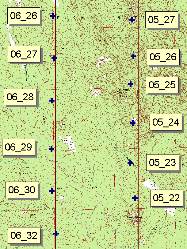
Figure 8.
FLTPLAN allows the user to easily and quickly georeference scanned aerial transparencies using the archive photo center points theme. TIF world files are automatically generated based on the photo nadir point elevation, nadir point scale, aircraft flying height, and the resolution of the scanned imagery. All world files are created in a user define location that contains the scanned imagery. As a result, when the user adds the TIF file to his ArcView project, the file loads as a scaled, georefernced data set that can be used to identify and delineate forest pest damage areas with a fairly high degree of spatial accuracy. Figure 9 shows the polygonal footprint for each photo point that takes into account the point scale of the photo.
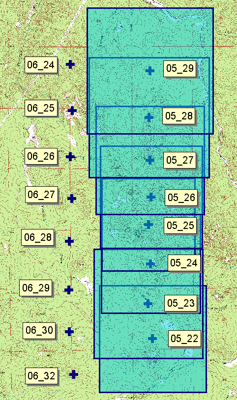
Figure 9.
Note how the size of the footprint changes along the flight line. This effect is due to the topography rising and falling along the flight line while the aircraft flys at a constant altitude. In this example (figure 9 and 10) there is a 2600-foot elevational difference between the smaller middle image (05_25, 9800 feet) and the large top image (05_29, 7200 feet). The middle image (05_25) has a smaller ground footprint because the aircraft is closer to the ground. Likewise, for the top image (05_29), the aircraft is farther from the ground creating a larger ground footprint. FLTPLAN takes into account these elevational differences to create the proper world file. Figure 11 displays a close up of image 05_29 overlaid on the DRG. The FLTPLAN created world file has properly scaled the image, even at the edge where displacement errors are greatest. The inner portion, or effective area of the photo image, will have the greatest geopositional accuracy.
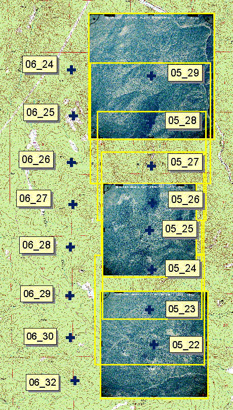
Figure 10.
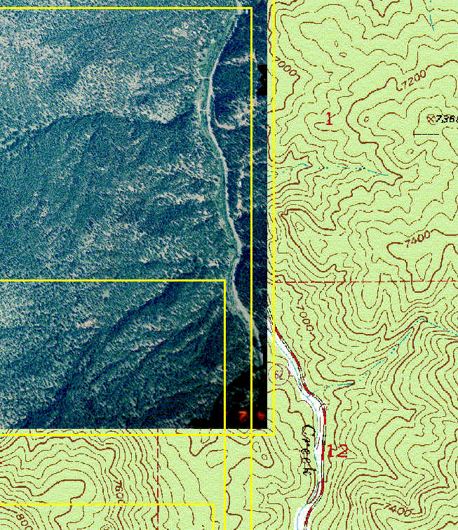
Figure 11.
FLTPLAN is an ArcView 3.2+ application that automates the process of aerial photography or digital imagery flight planning, flight mission archiving, georeferencing, and geo-indexing of scanned aerial photography. FLTPLAN gives new life to existing photographic technology by allowing the user to efficiently plan for and incorporate aerial photography and digital imagery into a GIS database in a fast, accurate, cost effective manner. Scanned aerial transparencies have high spatial resolution and, when used with GIS using FLTPLAN, become a powerful tool for locating and analyzing forest insect and disease.
I would like to thank Jim Ellenwood and Barry Russell, for their helpful and enthusiastic assistance with the FLTPLAN application. Without their knowledge and expertise was invaluable in figuring out how to approach this project or even how to calculate point scales or determine distance between flight lines. Special thanks to Suzanne Joy for technical editing.
Vern Thomas
GIS/Remote Sensing Specialist/Programmer
INTECS International, Inc.
vlthomas@fs.fed.us
970-295-5866
Jim Ellenwood
Program Manager
Remote Sensing & Image Analysis
USDA Forest Service, FHTET
jellenwood@fs.fed.us
970-295-5815
Barry Russell
Aerial Photography and Remote Sensing specialist
INTECS International, Inc.
blrussell@fs.fed.us
970-295-5869