|
|
ImageNet/County Marketplace2001
Esri International User Conference
|
Title of Paper
Partnering Municipalities with Private Sector
"The ImageNet/County Experience"
www.lacounty.imagenet.com
Author's Name
Chris Ryder, Project Manager
Abstract
Partnering with a large municipality (Los Angeles County, in this instance) to offer public information for sale and distribution over the Internet or an Intranet using TerraSoar software.
Paper Body
Background
At a GIS conference a few years ago, Core Software Technology ("CST") and Los Angeles County ("the County") were introduced and discussed the potential of the TerraSoar software in regards to dessimating assessor information to the public through the internet. The County has all the tax roll information in digital format and is busy digitizing the land base of the entire county. Distributing the information to the public was the next step and the software CST had developed allows for any user to search for any property in Los Angeles County and find tax roll records and GIS-ready parcel polygons.
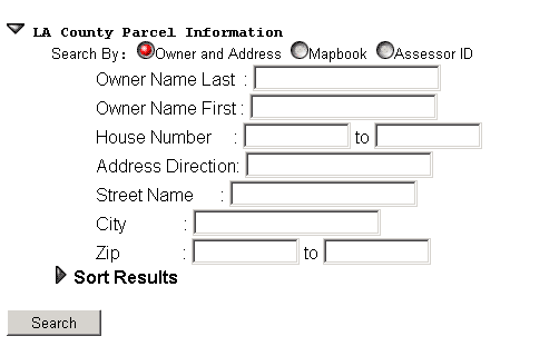
Time was spent developing a customized interface to the database, allowing searches by a number of options, such as owner's name, address, city, parcel numbers, etc. Preview images were created to make sure the customers was accessing the correct properties. An option to convert the tax roll information in the form of mailing labels was also created. The next step wil be to allow customers to make specific search directly from a map, allowing radius or polygon searches.
Parties involved with developing the ImageNet/County Marketplace Project
- Customers had been asking for a quick and easy way to access tax roll information, mailing labels, GIS-ready files for a variety of uses. They could already purchase the information from the County but this included parking fees, traffic, potential long lines, and a lot of time searching for hours . The internet was the perfect answer to access this information all from home or office.
- Los Angeles County has been asked by customers to get this tax roll information up on the internet for quicker access through quick searches.
- Core Software Technology has developed an online distribution system to access satellite and aerial imagery but the software is able to access any database (textual or graphical ). On the ImageNet/County site, the search is by a textual search such as by owner name, address, but eventually a customer will be able to search by map. The software also allows for various output format, allowing tax roll information to be distributed as mailing labels, and parcels as Esri-ready .shp files.
Technology Used
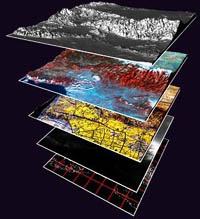
- TerraSoar Software enables providers and developers of geospatial data to easily make their archives available for network-based queries and distribution.
- Imagenet.com (home of the ImageNet/County Marketplace) is an online service providing access to geospatial data including the county's GIS-ready vector data, parcel and related assessor tax roll information and aerial photography and satellite imagery.
- ArcInfo is used to convert the coverages to .shp files and
- ArcGIS or ArcView are used to view the records as well as import the corresponding tax roll records to the parcel database is desired.
Customer Scenario
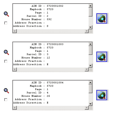
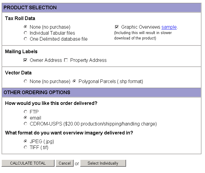
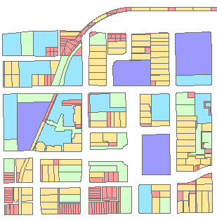
The Imagenet/County website will allow a user to search online for tax roll information or GIS-ready parcel polygon files. Within a search, a user will have options to search by: owner name, address, street name, city name, zip code, assessor map books, or parcel number. The immediate results of the search will show all the records that fall within the criteria the customer asked for. The customer can than highlight all the records or choose only specific records and add them to a shopping cart. From there, they can choose too order tax roll records (in table or comma-separated format), parcel polygons (in Esri. shp format) or mailing labels (in comma-separated format). The customer will receive a verification e-mail and then will receive the order in a second e-mail soon thereafter, connect to a ftp site to download, or will be sent on a CD for very large orders. From there, a customer can pull up the .shp files in a word processing program, a database or a Esri product for immediate use.
For example, a planner for Westlake Village may need all the parcel polygons for a large project development south of the lake. After a quick search on the ImageNet/County website, that planner could have those parcel polygons ready to pull up in ArcView for anaylsis, and then also import all the property information from the tax roll records.
Or a property developer may need a mailing label radius map for a project that she needs to bring to City Council for approval. She just inputs the assessor id's or addresses and get mailing labels within an hour.
Customer Experience
A customer will go through the following steps to gain access to the tax roll or Esri friendly-shp files.
1. Search for property
- By Owner, By Address, By Assessor Mapbook(s) or by Assessor Parcel ID(s)
2. Choose products from search results
- The search will create a list of results which the custoemr can either "Accept all" or choose only the results the customer wants. A magnifying glass allows for a more details and a quick-look vicinity map.
3. Choose product options
- The customer will then have a choice of options to choose from.
4. Order product by credit card or PO
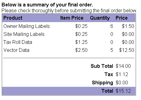
-The customer will then receive a summary of his order, the price and the final submittal button.
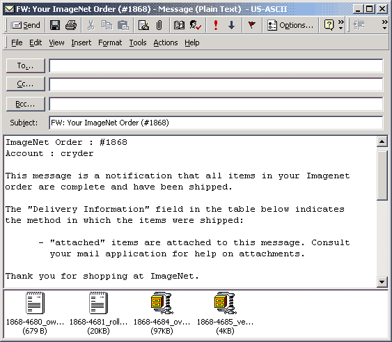
5.Receive product via e-mail or CD
6. GIS Polygons in Minutes
Partnership Summary
Acknowledgements
- Los Angeles County Assessor Office
- Richard Quacquarini
- Kathi DeLegal
- John Anderson- Core Software Technology
- John Ruccione
- Jon Heinsius
- Richard Parker
- Gene Smith
- Rob Zawarski
- Tony Loomin
- Don Bacon
Endnotes
Next phases will include:
- ordering by mapbook area or map page,
- an active map that is searchable by a drawn radius or polygon,
- searching by tax roll criteria, such as land use, price, date, county zoning, bldg area, etc.
- fly-through images of the properties in question
- high-resolution satellite imagery of the vicinity