Susan M. O’Neill
Paul E. Calhoun
Abstract
The City of Virginia Beach is a Project Impact Community on the Atlantic coast. As such we are developing a GIS program to support hazard mitigation and emergency planning efforts for hurricane preparedness, namely the identification and correlation of flood and surge zones with:
City of Virginia Beach
The City of Virginia Beach is the most populated coastal jurisdiction in Virginia with a population of 450,000 and steady growth. It is a unique jurisdiction in the sense that it maintains both agricultural and resort sectors in the midst of a thriving urban-suburban community. The city is home to several military facilities: Oceana Naval Air Station, Dam Neck Fleet Combat Training Center, Little Creek Amphibious Base, and historic Fort Story. Virginia Beach forms the southern gate to the Chesapeake Bay Bridge-Tunnel that spans the mouth of the Bay. The city is 310 square miles, of which 258.7 square miles are land and 51.3 square miles are water.
Risk Identification
The city's major risks stem from hurricane-force winds causing storm surge inundation and coastal erosion to the 38 miles of shoreline. The city has been impacted by northeasters that have occurred in 1927, 1948, 1956, 1962 and 1998. FEMA statistics show that the city has 17,191 flood insurance policies in effect. This constitutes one fourth of all policies in Virginia with coverage totaling approximately $230 million.
In 1998, Virginia Beach became the second site in the Commonwealth of Virginia to be named a Project Impact Community. The first was the Roanoke Valley. As I’m sure you’re aware, the Project Impact concept was developed to move emphasis from a “damage-repair-damage” cycle to one of disaster resistance, in order to mitigate damages from natural and man-made disasters. It’s a community-based initiative that includes:
Consequently, in March of 2000, the City of Virginia Beach, the Commonwealth of Virginia, the Federal Emergency Management Agency and 50 local businesses and organizations signed an agreement to create a disaster resistant community. The document established the Virginia Beach Project Impact Partnership, outlining activities that each party would take to reduce the community's vulnerability to disaster.
The agreement has resulted in a comprehensive emergency management outreach program which has significantly increased awareness of potential hazards for residents and businesses:
In recent history, Virginia Beach has been spared the brunt of most Atlantic hurricanes, although it’s had some close calls. In August of 1998, hurricane Bonnie, a Category 3 storm, made landfall near Cape Fear/Wilmington, North Carolina. Bonnie then moved north through the Tidewater area of Virginia, causing local flooding from rainfall, but coastal flooding from storm surge was negligible.
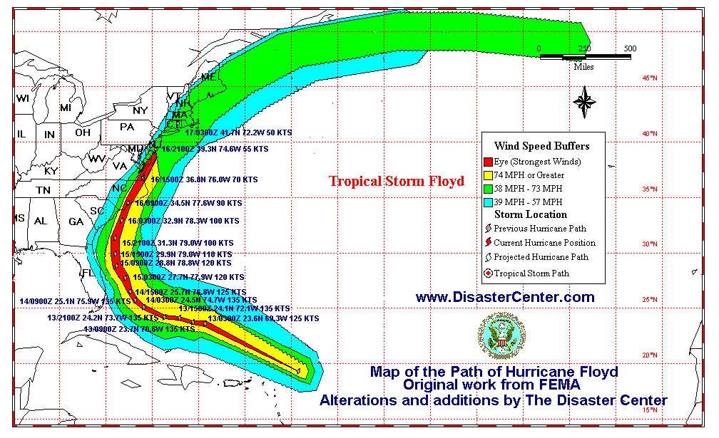
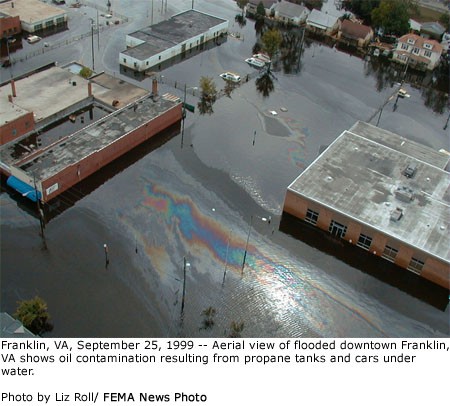
In September of 1999, Hurricane Floyd cut a path through Virginia that passed just west of Virginia Beach. The greatest impact was approximately 60 miles west of Virginia Beach in the town of Franklin, Virginia.

In addition to the damage from flooding, a major problem in Franklin was the combination of flood waters and oil from cars and propane storage tanks, which created an environmental disaster that required specialized cleanup efforts.

As part of the new hazard mitigation efforts, and with the help of the Project Impact / Esri Community Challenge Grant, the City of Virginia Beach Center for GIS began work on a project to correlate flood and surge zones with the location of existing:
Data Sources
The City of Virginia Beach began its Land Information System in 1976; all parcel base maps were completed in 1980. In 1988 Virginia Beach requested a new flood zone study by FEMA to keep up with the increased growth. Due to the enhanced digital data the City possessed (2' contours with 1/10 foot spot elevations), and staff, Virginia Beach was awarded the contract to supply FEMA with digital data of the revised flood zones determined by the Army Corps of Engineers. This was the first time a municipal government's digital data was used to aid in flood zone determination. All tax parcels, land use, FEMA flood zones, hurricane surge zones, building footprints, spot elevations, and waterways have been digitized. The majority of Public Utilities line data has been digitized and integrated with GIS since 1995, including geolocation of pump stations. Storm Water Management data is approximately 95% mapped, although there is still some integration with maintenance and work order data remaining to be done in order to make full use of GIS functionality. All centralized data is on NAD83 Virginia South coordinates.
Like most technology at the City of Virginia Beach, the GIS system developed in a distributed manner, with several departments, including Public Works and Public Utilities, operating separate systems for several years. Recently, in order to make more efficient and effective use of time and effort, the various departments have undertaken the creation of an enterprise GIS system. Centralization of GIS data will allow more extensive analysis of cross-sectional GIS data.
Several data conversions were undertaken as part of this project, including the conversion of parcels and waterways from line data to polygons. All Flood and Surge Zone data used in this study was compiled by the Army Corps of Engineers and originally stored as Microstation dgn files. During the project, it was converted to Arc Shapefiles.
The most challenging aspect of the project was the acquisition of underground storage tank data and HAZMAT site data. Some information on the location of underground storage tanks was available from City departments, but mainly restricted to those owned by the City government. The most valuable information was located on the Virginia Department of Environmental Quality internet site, which contains a database of all underground storage tanks identified by the DEQ as leaking. Obviously, this does not provide a complete inventory of UST sites, but it provided a starting ground for the study. However, the available data was not in the same projection as City GIS data and required conversion. The acquisition of HAZMAT data has also been a challenge. A list of known HAZMAT sites was provided by the City's Fire Department in Microsoft Excel format, which was then converted to database format. However, manipulation of the file was required to convert address fields to the City standard format to allow cross-referencing with the parcel database. Once converted, matching the addresses of HAZMAT sites with parcel data resulted in xy coordinates for all sites, which were then geolocated in ArcGIS.
Analysis
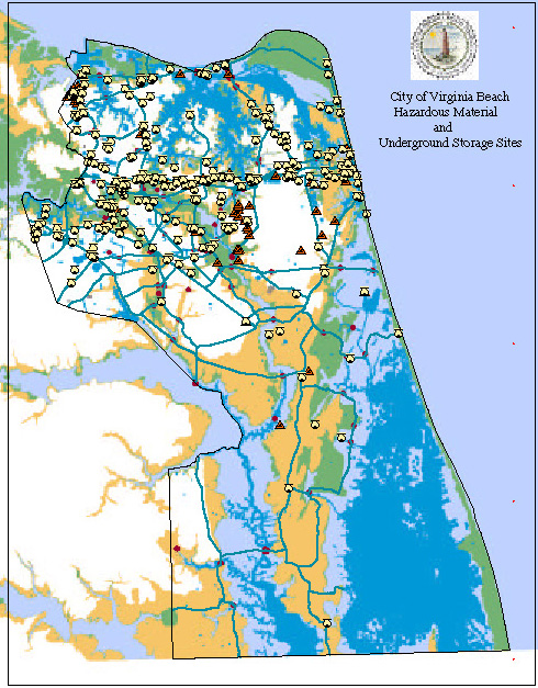
The following map shows all identified HAZMAT sites and UST sites for the City of Virginia Beach:

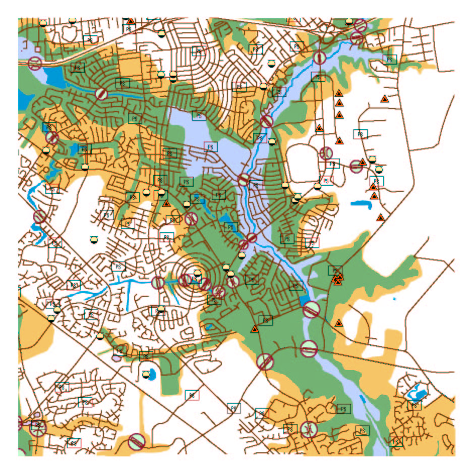
The image below shows one portion of the city with AE flood zones (green)and 100 year flood zones (brown) depicted along with identified HAZMAT sites and underground storage tanks.

As of June 30, 2001, all analysis has not yet been completed for the USTs and HAZMATs. The Center for GIS will continue to work with various City departments and other agencies to gather additional information. The resulting analysis will assist the Project Impact group in planning hazard mitigation for the City of Virginia Beach.