Traffic models are used to justify investments in new multi-modal terminals, the improvement of the waterway infrastructure and for policy studies in general. The aim of the BVMS model for inland shipping traffic is to predict future streams of commodities transported by inland shipping between economic regions and translate these into movements of ships on the waterways network.
With this model, the policymakers will be able to compare different scenario’s with each other or with a reference situation. Spatial data, both on the waterway infrastructure and on traffic flows is the backbone of the model and therefore GIS has a central place in its design. ArcInfo 8 is used for datamanagement, casemanagement and visualization and analyses of the model output.
Given the expected growth in overland traffic and the resulting congestion problems on the roads, the encouragement of inland shipping is one of the key topics in the transportation policy of the Dutch government. Traffic models are used to justify large investments in new multi-modal terminals, the improvement of the waterway infrastructure and for policy studies in general. TNO and Esri Nederland cooperate in a consortium with 3 other partners in the development of a new traffic model for inland shipping. The aim of this model is to predict future streams of commodities transported by inland shipping between economic regions and translate these into movements of ships on the waterways network.
With this model, the policymakers of the Ministry of Transport, Public Works and Water Management will be able to compare different scenario’s with each other or with a reference situation. Spatial data, both on the waterway infrastructure (rivers, canals, locks, bridges, terminals) and on traffic flows (origin, destination, type of goods) is the backbone of the model and therefore GIS has a central place in its design. ArcInfo is used for datamanagement, casemanagement and visualization and analyses of the model output. This paper covers both the conceptual design of the traffic model and the integration in the ArcInfo 8 environment.
Freight transport is of essential importance for the Netherlands. The origin for that can be found in the past. Since the middle ages the Netherlands has positioned itself as a trading country, strongly depending on trade and transport related activities. The main reason was the lack of own natural resources and the lack of an own local industry. Of course: the Netherlands is well known for its tulip bulbs and wooden shoes and these are products that certainly have been exported to other countries, it is clear however that these flows could not be the only source of income. As trading country the Dutch have travelled the seas and established trading relations earlier than other countries did. In the 16th century the United East Indian Company (VOC) established trading posts throughout Asia (Ceylon, Malakka, Indonesia, Japan or China) and shipped quality products such as silk, porcelain and spices to European customers and between Asian countries. Within Europe, waterways have been the main infrastructure for international freight flows up till the railway period that started in the middle of the 19th century. The Netherlands was well located for these waterborne flows because of its harbours and strategic position in the Rhine/Schelde delta.
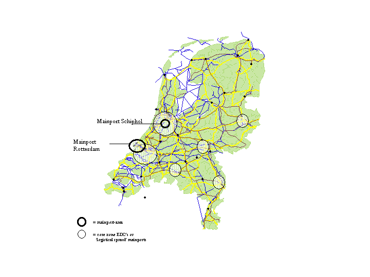
Being a small country (in the periphery of Europe, representing 2-3% of Europe in terms of population or surface area.) and speaking a specific language that other people do not learn easily can be a strategic advantage. The Dutch are known for their multi-linguistic abilities. This often creates a big advantage in establishing trading relations. When the age of containerisation begun in the early sixties of the former century the Dutch quickly saw the opportunities this new way of transportation offered. One of the good examp-les for this is the development of the harbour of Rotterdam to one of the most important harbours (of the world. Rotterdam invested heavily in handling equipment for efficient transhipment of containers to inland modes of transport. Another strategic advantage has been the ability to accommodate the largest bulk ships, thus enabling Rotterdam to become one of the largest oil ports of the world. Through the deepening of the connection from Rotterdam to the sea to 70 feet, large oil tankers – up to 500.000 tonnes – are able to call upon Rotterdam This superior maritime infrastructure did enable not only the establishment of transhipment points and storage facilities but was one of the most important backgrounds, leading to the emergence of a chemical cluster around the port of Rotterdam (and later Antwerp as well). The chemical cluster is concentrated on the refinement of crude oil and the distribution of derivatives to production facilities in the port itself and elsewhere in Europe. Chemical products are exported world wide to destinations including the US and Asia Pacific. Besides Rotterdam, the Netherlands is well known because of the airport of Amsterdam, Schiphol airport. Both Rotterdam and Schiphol have been decisive factors for developing the Nethterlands as a logistic distribution super hub, the functioning of these ports as so called mainports especially contributed to this hub function. The concept of establishing transhipment centres lead to the possibility of creating economies of scale and scope. The ‘hub and spoke’ concept is crucial to achieving these economies. Large transhipment centres for containers and bulk cargo, or air cargo; the hubs, are linked to smaller transhipment centres: the spokes. In the Netherlands, these hubs or gateways (Hayuth 1987) are called ‘mainports’. Although the mainport concept is based on the concept of a container gateway, the concept has a broader content and includes industrial and service activities related to the transhipment as well as indirect linkages (forward and backward). The mainport concept therefor is an excellent example of a cluster or regional economic complex (Krugman 1997).
Talking about freight transport in the Netherlands one can conclude as follows. Over the past years the growth of freight traffic, both domestic and foreign, has been significant. Economic development in Europe, reinforced by the elimination of the borders within the European Union on January 1993, has strongly stimulated freight flows. The rule of thumb is that goods transport develops at a rate at least equal to that of the economy as a whole. The facts demonstrate that over past decades the growth of transport has been higher than economic growth. This growth will continue, due to the more intensive trading relations with the former East European states, but also due to the continuation of the European integration, the further globalizing of the economy and the fact that the population of the Netherlands continues to grow (by 2 million in 2015) Moreover several European scenario’s produce forecasts of 30 and 80 % by weight growth in transport by 2015. A very significant part of this growth (ca 40 % in tonkilometers) will continue to pass over the roads. The situation of today related to the mentioned developments leads to a situation of constant concern. Without diminishing the positive achievements of the goods transport sector, we cannot avoid accepting that in contrast to all of the positive effects of the growing flows of goods there are a number of negative social effects involved. This leads to a situation in which all the parties concerned are looking for a right balance between economic growth and the effects of the growth of freight transport which is directly related to that. A balance between demand and supply, between economic factors and demands of the environment and between the various forms and modes of transport. Much creativity is needed in the fight against congestion, environmental pollution and against a decreasing accessibility of the economic centres and mainports.
Transport is an elementary economic activity. An effective freight transport machinery is a primary condition for growth and survival of the economy. In order to establish the position of a gateway of Europe, with high quality hinterland connections, a few conditions has to be fulfilled. This conditions are based on the awareness that no body would consider treating such a critical important sector as good transport without the greatest care and consideration. Road transport, inland shipping, short sea (coastal traffic), air freight and transport by pipeline are all sub-sector deserving and receiving the greatest attention and effort.
Talking about economic growth is in the Netherlands talking about the growth of freight transport. To avoid a situation in which only road transport will have to facilitate this growth the development of alternative transport modes as mentioned before is stimulated. Not only by the Netherlands government, but also increasingly by market parties itself, because they more and more see the benefits of it. Against the background of the so named National Traffic and Transport plan of the Netherlands Ministry of Traffic, Public works and Water Management a policy has been developed in order to create a transport efficient economy, and an efficient, safe and sustainable transport system. Modal shift from road to rail and inland waterway’s and Intermodal transport, as well as more efficient road transport (transport effectiveness), will contribute to the further development of the Netherlands as a transport nation and as a nation as an excellent place of location of business for both domestic and foreign commercial operations. This is partly thanks to the excellent quality of national transport and logistics services.
In the current organisation of freight transport the road plays, as said before, an important role, especially nationally, and will continue to play an important role in the coming decennia. Looking at the increasing congestion problems however, it is important to look for alternatives. Alternatives in which the combination is sought between road transport (flexible, fast and everything can be reached) and other transport modes (scale, reliability, cheap). One usually refers to bundling of freight flows in logistic networks. In the national Transport plan a picture is sketched of an effective and efficient freight transport network in 2030.
The transport types are completely interactive; use can be made of several forms of transport without time loss of extra costs, not only due to ICT but also due to the development of fast and cheap types of transhipment. Hereby use is not only made of large terminals but also of flexible small transhipment facilities.
The largest part of modal shift will have to be achieved by multi and intermodal transport. This means that in many cases the replacement of road transport by train, inland vessel or short sea will be possible only for a part of the route. For the “pre and post” transport trucks will almost always have to be used because of the fact that trucks, in contrast to train and inland vessel can get just about anywhere. The intermodal transport system is a chain or sequential system consisting of a number of links that have to be fitted to each other. Essential components are the junctions (transhipment terminals), the transport links between the junctions by train, sea vessels and inland waterway vessel and the road transport that ensures the movement of goods between the junctions and the initial shippers or final recipients.
The favourable developments in the intermodal transport sector can be derived from a number of developments:
- the use of standardised units
- the increasing supply of “door-to-door” services
- Some transit lands in Europe only give permission for freight transport through their country by rail.
Transporters and forwarders who wish to retain or develop their market share are increasingly working with combined forms of transport (road-rail).
An important obstacle for the success of intermodal transport is reliability and costs. Intermodal transport will lead to extra transshipment and thus transshipment costs. TNO Inro is participating in an international project RECORDIT, initiated by the European Commission, which will give an overview of the transport costs of a number of selected intermodal corridors within Europe. The results of this European project could be the base of a new policy by the European Commission.
Privatisation and liberalisation did not till now create a situation in which freight transport by rail can compete with road transport or transport by inland vessel. One of the main reasons for that are the internal European borders. There are in the meanwhile initiatives to allow border crossings to operate more easily and conveniently.
A few important developments of rail transport are
- the growth in container transport, and the suitability of containers for transport by rail
- the increasing demand of long distance services
- the barriers road transport is facing in the Alpine countries
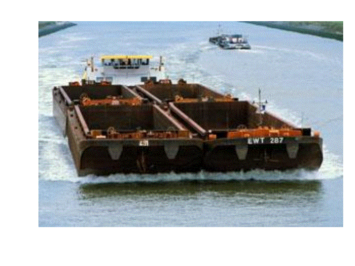
The Netherlands is an inland shipping country! The Rijn and a fine meshed network of inland waterways with connections to Germany and Eastern Europe is available. More and more inland shipping develops as a real alternative for shippers. A large part, some 35 % of the hinterland transport of sea containers is already transported by inland vessel; and the forecasts for the future are excellent. The increase in the numbers of containers shipped to Rotterdam and the growth of market share will ensure further development in this segment. But not only the attractiveness for containers is growing, also for the transport of pallets on a long distance shippers are interested in the services inland shipping can offer.
A logistic network based on inland shipping can already be realised. The infrastructure and techniques are already available and inland shipping is the only transport type in inland transport where a shortage of capacity of the infrastructure does not form a problem. The inland shipping has proven that a large share of the import, export and delivery of maritime containers can be realised with a minimum of investments in infrastructure. The central question of a study TNO Inro worked out last month was to determine whether inland shipping can form a significant role in another high value freight segment, whereby especially the transportation of pallets was researched.
Main goal of the inventory study was to define the potential market area for pallet transport by inland ships and to start the design and development path for a successful inland shipping network. The study consisted of three parts: a market inventory, design and development of a model, a report and exchange of knowledge. In the market inventarisation the characteristics of inland shipping were researched, the palletised freight transport in The Netherlands was mapped and an extensive study was done one the organisation of logistics in the retail sector. This resulted in an estimate of the freight flows of big Dutch retail companies as Albert Heijn, Laurus, Schuitema and Aldi. For these retail chains the spatial logistic structure was mapped and based on production numbers from the different distribution centres in colli per product category and production information of suppliers (production size, locations and package sizes) an estimation was made of freight flows in pallets from supplier to distribution centres. Hereby it was assumed that distribution centres were supplied on a daily basis.
The model results show that with a nation-wide network of 10 inland shipping terminals 23% of the fastmovers from producers to retail distribution centres can be carried out by inland shipping. This is approximately 1 % of the total inland freight transport (saving 48 million vehicle kilometres) The total savings on the transport costs are approximately 22% compared to complete transport by road. Through the combination of several shippers the loading degree of the ships and the occupation of the transhipment terminals is high. This high occupation lowers the costs for the longer trips, which are not possible without return load or more expensive, as well as the minimal distance at which transport by inland shipping becomes interesting. It appears that even for customers with a relatively short transport distance (less than 140 kilometres) that from a cost point of view use of the network is interesting, this is also shown by the relatively low transport distance of 158 kilometres in the maximum network.
On behalf of the Ministry of Transport, Public Works and Water Management TNO Inro is together with Esri Nederland working on a new traffic model for inland shipping. This project and the project mentioned above prove the importance for both policy makers and market parties of inland shipping in the Netherlands.
The purpose of the new strategic model system for inland shipping is to allow more detailed insight into the long-term development of inland waterways traffic in and around the Netherlands. This insight is necessary for a well-founded policy with respect to the development of the inland waterways infrastructure. The model is designed for performing stimulus / respons analyses, where the stimuli comprise autonomous developments in policy measures related to the inland waterways system, and the response is expressed in freight traffic flows by inland waterways. The main users of the system will be the policy makers at the Ministry of Transport, Public Works and Water Management and those concerned with infrastructure development related to waterways.
The three main components of the system are the user interface, the database and the calculation modules. User interface and database are being developed in ArcInfo 8.1, the calculation modules are external routines written in C++. The calculation modules comprise a number of sub-modules, of which a modal choice model, a traffic production model, a traffic assignment model and the calculations of external impacts from traffic flows are the most important. The working of these calculation modules will not be discussed here, as it is too specific mathematical juggling with figures. For here, a general description of the structure of the model system and its modules will do.
The next diagram shows the structure of the Inland Shipping Model System as a data flow chart.
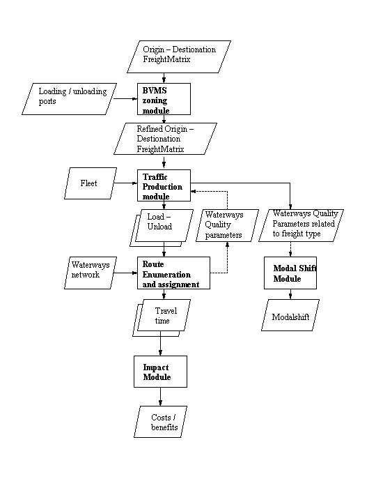
The function of the BVMS zoning module is to simply convert large scale economic statistical regions into smaller, more appropriate traffic regions.
In the traffic production module, flows of freight are translated into trips (voyages) of vessels. This part comprises the most complex part of the whole model system. Moreover, this module is substantially defining the outcomes of the model system and thus the policy scenario’s to be assessed.
Route enumeration and assignment simulates the interaction between the traffic demand and the capacity of the infrastructure. In the case of BVMS, the traffic demand is specified in a load – unload table, while the availability of the infrastructure is specified by the waterways network with its attributes. This part of the model comprises the following steps:
· simulation of the route selection;
· simulation of the traffic flows on the network links: what is the traffic load, where do delays occur;
· simulation of the time of departure from loading / unloading quays;
In the Inland Shipping Model System (BVMS), the calculation of model-shift serves two purposes. First, modal shift is an important category of benefits from investments in inland waterway infrastructure. And second, modal shift has its impact on the volume of freight traffic flow on the waterways network.
Output of the model, with the exception of the modal shift, is available for each network link for each type of vessel. The impact module aggregates output to different levels, for instance:
· all vessels in the Netherlands;
· vessels of a particular type (e.g. bulk carriers, container ships;
· all vessels on a particular link or route;
· vessels of a certain class on a link or route;
· etc.
The proposed models have been thoroughly discussed with several experts in the field. A risk analyses at the beginning of the project identified the availability of data as the main risk.
As the Inland Shipping Model System has a substantial spatial dimension, it is decided to use standard GIS software (ArcInfo 8) as the environment to build both the database and the user interface. Esri is the standard for GIS within the Ministry of Tranport, Public Works and Watermanagement, so the future users of BVMS have knowledge of GIS and ArcInfo.
First, let’s take a look at the user interface. One of the core functions of the user interface is what is called ‘case management’. Case management controls the flow of the modeling process. This functionality is build into ArcInfo’s data management environment, ArcCatalog. Users define model runs and manage input and output data. The standard method of working defines the design of this part of the interface.
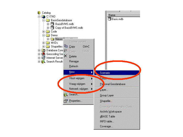
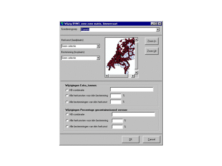
Users can build cases by defining a scenario and setting the various parameters of the model. With context sensitive interfaces, parameters like fleet data, destination – origin freight matrix data and network characteristics can be tuned for a model run.
The following screenshot shows an interface to manipulate the demand for freight transport capacity to and from a given zone.
Usually, for one policy issue or one question, a number of different scenarios and variants are calculated and compared.
The database is the heart of the model system and is implemented as a Geodatabase in ArcInfo / Oracle. Roughly, the database can be divided into three parts.
· Network (waterways, locks, bridges)
· Fleet (vessels, vessel types)
· Demand matrix (Origin, destination, for 200 zones, 60 types of commodities)
Modeling the network in ArcInfo was a major task, particularly because of the discrepancy between the structure of the mother database and the requirements of the modeling software.
One of the key elements in the model system is the network. The modeling network describes all attributes of the system of waterways in the Netherlands which are relevant for route selection. In total, the model specification for the network comprises of 16 tables.
	Table				Contents
	1.1. link			Navigable connection between two nodes
	1.2. nodes			Geographic position
	1.3. origin			List with nodes that are origin locations for freight movements
	1.4. destination		List with nodes that are destinations for freight movements
	1.5. waterways			Collection of connected links (waterwaysegments) . Used for presentation purposes
	1.6. waterwaysegment		Link that represents a segment of a waterway
	1.7. chamber			Link representing a chamber in a lock
	1.8. lock complex		A collection of lock chambers on a particular geographic location
	1.9. bridges			Link that passes underneath a bridge
	1.10. service periode		Table with the service regimen of a lock or  bridge in a season
	1.11. service regimens		Table with the definition of service regimen
	1.12. background load		Background traffic on a link resulting from recreation traffic
	1.13. season rate of flow	Rate of flow on a link in a season
	1.14. season depth		Navigable depth on a link in a season
	1.15. depth-frequency		Frequency distribution of the navigable depth (waterlevel) per season for the network
	1.16. counting point		Indentification of counting points, connected to links
Since early 2000, the Ministry of Transport has an extensive database (National Infrastructure Database - NWB) at its disposal that contains all the roads, railroads and waterways. It proved that this database is a suitable and comprehensive representation of the waterways network for mapping and statistical analyses. For modeling purposes, conversion was necessary.
The bottom line of this conversion process is that the NWB network database is build on dynamic segmentation while the model software requires a network comprising only simple links and nodes. So the entire DynSeg network has to be broken down into simple (linear) segments. Another complication are locks. Many locks do have more then one chamber, often with different dimensions. In the NWB network, locks are point features. For the modeling network, the locks had to be converted from points to line segments, with one segment for each respective chamber.
The network for the baseyear of a modelrun can be different from the network in the forecast year. ArcInfo functionality is used to add new links to the network, representing new waterway infrastructure elements like new canals, new cambers in locks or new terminals. Or to change the network characteristics by changing one ore more attributes in the model database. By manipulating the model network, the user gets insight in the effects of improvements in the waterways infrastructure, like the construction of largers locks or the widening of a canal. By comparing the traffic on the network in the baseyear with the predicted traffic, one gets a clear view of the future network loads. GIS maps show where the bottlenecks are or where the enhanced capacity facilitates a growth in freight movement by inland shipping.
Presentation of the results can be on maps, in lists, tables and charts. A number of predefined reports and maps will be available through the user interface. This standardized output is directed to the general users and policy makers. More experienced and advanced users have the full functionality and flexibility of ArcMap (and Seagate Chrystal Reports) at their disposal to compile their own user defined output.
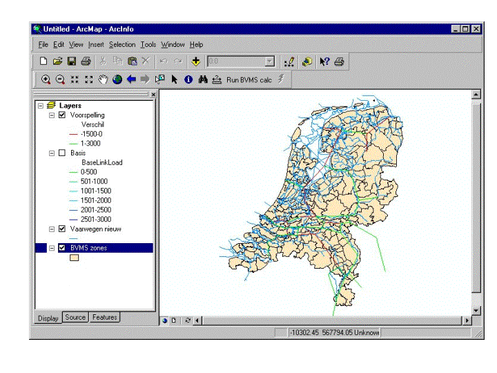
One example of standardized output is the ‘difference map’. This map shows the changes in traffic load on (a part of) the waterways network as a consequence of certain policy measures or as a result from improvements of the infrastructure.
At the time of the writing of this paper, the development of the model system is halfway. The database is available as a Personal Geodatabase in ArcInfo, many components of the user interface are there and some preliminary examples of the output that can be generated by the system have been demonstrated to the Ministry.
To be able to proof the proper working of the proposed model system, we started to build the different modules in MathLab. MathLab is a kind of ‘casetool’ for mathematical models. The MathLab modules are integrated in the ArcInfo environment.
The following images shows an example of a ‘difference map’ created in ArcInfo with the output of the MathLab models. Of course, we don’t run MathLab on top of the full-blown network. Instead, a simplified network with only a couple of zones and a small number of links is used to prove the working of the models. On the map, we see MathLab data projected on the real waterway network.
The new Inland Shipping Model System BVMS has many promising possibilities for research and policy development in the field of freight transport over water. In the future, a rich palette of questions can be answered with the help of BVMS.
Think of questions like:
· What will happen of prices of fuel and salaries rise in the future. It is expected the larger vessels will be used, but what does that mean for the traffic on the waterways ?
· What are the consequences of an ongoing reduction of the steel industry in Germany. Does this end up with a reduction of push-towing on the river Waal?
· What are the consequences of the restriction of vessels carrying hazardous goods on the Amsterdam – Rijn Canal?
· What will happen if a large multi-model inland port of transshipment will be developed near Arnhem?
BVMS leverages the Ministries understanding of the complex matters that are involved in infrastructure development, waterway management and strategic decisions with respect to freight traffic policy.
Ruijgrok, C, Kuipers B (2001) Transport Infrastucture Management for attracting European Distribution Centres in the Netherland, TNO Inro
Hayuth, Y. (1987) Intermodality: concept and practise. Structural changes in the ocean freight transport industry, London: Lloyd’s of London Press Ltd..
Transport in Balance (1996), Ministry of Transport, Public Works and Watermanagement
Groothedde et al. (2001) Kansrijke Binnevaartnetwerken, TNO Inro
We like to thank everybody who is involved in the enormous effort that eventually will lead to the birth of the new Inland Shipping Model System. The partners in the BVMS consortium:
TNO Inro, Delft
QQQ Software, Delft
NEA Transport Research, Rijswijk
Esri Nederland, Rotterdam
Technical University, Delft
And of course Jolco Brolsma and Ernst Bolt, representing the Ministry of Transport, Public Works and Water Management.