SPATIAL MODELING FOR GASB 34 AND FISCAL ANALYSIS
INTRODUCTION
The General Accounting Standards Board (GASB) 34 requirements not only met their lofty and intended mark of requiring sound fiscal practices, but they also attained unintended benefits by providing the long needed fiscal connection to infrastructure and facilities planning and development. As a result of meeting the GASB 34 standards, governmental agencies at all levels must develop a complete inventory of assets and liabilities for all infrastructure and facilities with maintenance and operational costs as well as revenues and expenditures. As shown by the examples of the City of Phoenix Planning Department and others, these data not only provide sound financial accountability, but the information necessary for obtaining bonding, grants and loans, recalculating impact fees and utility rates, estimating the cost of development, annexations costs and many other applications. In reference to spatial applications, GASB 34 standards offer an ideal opportunity for Geodatabase applications that link object-oriented and relational databases to Esri GIS packages. Add to this a planning and analytical package such as metroware( and metroware GASB(c) and you have a complete cost data spatial-fiscal analysis that addresses existing and new development as well as replacement costs and facilities. A GASB 34 Geodatabase with the robust capability of Esri and metroware software enable governments to be fiscally prudent, while providing sound Capital Improvements Planning (CIP).
SELECTED metroware GASB(c) GIS BASED APPLICATIONSMap 1. Phoenix Desert View Planning Area 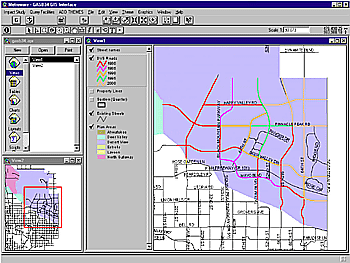 |
Using metroware's Esri GIS native software makes life easier for the staff administering fiscal related local government activities. One promising area of application for the software packages is the integration of spatial, fiscal and physical data with the governmental development of facilities, infrastructure and finance into capital planning and budgeting. metroware GASB not only meets, but exceeds all GASB 34 requirements for compliance, by providing a sound method for costing historic, new and future infrastructure and facility development. In the past, municipal information on capital physical plant such as street and water systems has been, and frequently still is, separated into different and often incompatible formats. Spatial physical and fiscal information were found in different formats on both electronic and paper spreadsheets and summary tables. The development of more powerful desktop and mini-computers with sophisticated software such as Esri GIS, ArcSDE, Geodatabase and metroware enterprise systems connect programs and databases, via Internet-Intranet. This enables governments to combine all of types of data into one cohesive spatial information system. The systems do not require the use of all internal metroware data gathering packages to use metroware's analytic applications for fiscal and physical development analysis. The metroware examples use the City of Phoenix Arizona and other data for applications. For the screens we have chosen the Desert View Planning area as shown in Map 1. Phoenix is the fastest growing City in the nation and Desert View one of the fastest growing areas in the City, more specifically Desert View - South, is the fasting growing area in Phoenix.
Map 2, Desert View South Infrastructure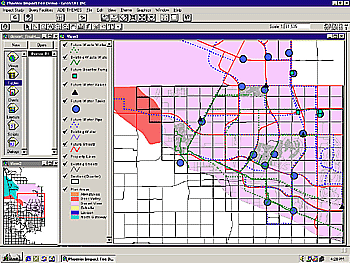 |
Map 2 shows the study area Desert View South with all existing, developing, and future infrastructure for water, wastewater, and surface roads and streets. The data gathered for this area include the entire infrastructure, with the cost of development including bonding and interest. Using this information with other financial data we developed the routines for determining the Impact Fee and the GASB 34 programs. These routines also are applicable to the infrastructure and facilities development and cost estimating routines. These same data with additional spatial applications are applicable to provide cost estimates for new development, with alternative development scenarios, annexations, and other analytic spatial/fiscal solutions.
During the same development time period of the GASB 34 standards, the American Planning Association (APA) and local groups developed the Growing Smarter movement, while at the same time, the U.S. Department of Energy created the Sustainable Development movement. These programs recognized the need to mainstream the principles and practices of smarter and sustainable governmental and private development within environmental, energy and fiscally sound constraints.
Table 1, Surface Transportation Inventory and Costs Table 2, Road Costing Examples 
|
Governmental executives and managers in administration, budget, economic development, engineering, finance, planning, public works, utilities with the elected officials and the lay advisory commissioners they serve, constitute a particularly important and receptive audience for information about fiscally smart sustainable development within fiscal constraints. They have a commanding influence over public policy at the local, regional and state levels, and help guide the interaction between the built and natural environments. These responsibilities include the preparation of a range of plans from capital improvement plans to long-range comprehensive plans that seek to weigh and balance claims on scarce economic, financial, land, social and other resources. They also have the responsibility for analyzing and recommending actions concerning individual development proposals that, when analyzed with other proposals, often have long-term, cumulative impacts on a community's environmental, economic, and social makeup.
GIS-based data gathering with metroware spatial analytic software and sound geodatabases enable governmental staff to gather minutia on facilities and infrastructure at the component level, (e.g. water system valves, elbows, T's and pumps at their exact location, line and segment locations with size, flow, pressure and cost). These metadata provide a cornucopia of long needed data that produce sound analytic modeling.
The gathering of precision infrastructure and cost data, by utility segment and capacity, with the capability of summing benefit areas, such as drainage basins, enables staff and officials to use the robust power available in GIS for decision-making. This includes not only financially sound reporting with numerous options allowed under GASB 34, but sound capital improvements planning and budgeting. GASB 34 finally requires governments to use asset and liability data, including maintenance, replacement, operations and interest in the depreciation of infrastructure and facilities.
These activities extend the actual lifecycle and value of governmental assets. Executive and line staffs are enabled to prepare accurate estimates of actual cost, with contingency costs, for new development as well as replacement based on real projects by design and construction components. New development with land use alternative scenarios can be reviewed in terms of their actual infrastructure and facility requirements and costs. Land use mixes and densities can be changed while at the same time calculating the demand for physical improvements comparing associated costs.
Table 3, Water Infrastructure and Costs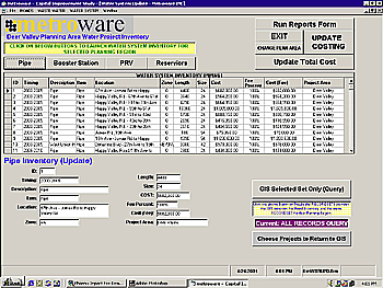 Table 4, Historic Capital Development and Costs 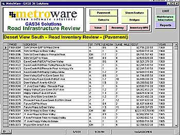
|
These improvements can be further designated as to the specific responsibilities for the developers and for each government. Executives can review proposed development and suitable alternatives 'on-the-fly' for each development scenario. Costs for future infrastructure are demand based on the actual requirements for selected development alternatives. Costs may be projected using actual recent data. The GASB 34 Geodatabase includes the entire asset development since 1980 with new infrastructure and facilities capacity and costs, which update as are developed. This is an ideal application for ArcFM and metroware. metroware GASB 34 has taken once academic and theoretical concepts and dreams of the late 20th Century into a complete 21st Century Internet-Intranet Enterprise Program Management System. The new GIS Geodatabases applications with associated analytic software tools accomplish once impossible tasks in mere nanoseconds. The possibilities for GIS are still in their infancy and are inviting many professionals into the field. metroware's unique software is designed with specific expertise in associated fields of accounting, administration, budgeting, economics, engineering, finance, planning, public works and utilities. Their development capabilities go well beyond exciting in our next generation 'nextgen' cross platformable Internet-Intranet JAVA software applications. These new development applications go beyond exciting to new levels of conceptual application development. The user receives a comprehensive understanding of the methodology and meaning of all results and reports. However, users do not see the complexity of the engineering, fiscal, mathematical, physics and programming in the modeling, which could be quite confusing. metroware uses the same Geodatabase infrastructure, facilities and cost data for capital improvements since 1980. These provide a sound basis for estimates of future capital development, thereby enabling management, finance and planners with realistic development and cost data, as shown in Table 3. The data may be used for fiscal analysis, GASB 34 reporting, or planned development scenarios and alternative costs, or annexation associated costs to name but a few of the applications. The basic GASB 34 requirements include historic capital development from 1980 forward to the current year. The new capital improvements are to be entered in the year of construction and future capital infrastructure development estimated.
metroware GASB 34 Scope
Fortunately the same data required for GASB 34 are transferable to many other fiscal planning applications including estimating future development costs, impact fee calculation and updates, capital improvement plans and budgeting for both annual and long-range capital planning and budgeting. In the next few years GASB 34 should well provide the fiscal interface for most governmental administration, finance and capital planning activities. With an enterprise approach the entire governmental operation can be managed at executive to line levels with each level having access to its necessary data elements. In tracking existing and future water lines, as an example, water utility departments are enabled to track new development from land use changes to new subdivision approval, through preliminary infrastructure engineering, plans, design and approval with change orders and actual construction location. These data include the actual final construction with cost for the system by main and distribution lines and actual costs by each system component. The development process is tracked through details and compliance, with design and time schedules by the utility department. At a more general level tracking is conducted by public works, and summary information is provided at the executive level. General reports are available for elected and appointed officials. Top executive staff can review progress through the Intranet-Internet, as well as hold online conferencing on progress and other issues.
GASB 34 requirements consist of straightforward sound accounting principles, which apply to all state, local, school districts, public benefit/service authorities as well as other public and quasi-public districts and entities. There are approximately 100 metroware GASB spreadsheets, depending on the complexity of the governmental agencies, with 30 spatial/fiscal routines and subroutines providing special FM reports and calculations in the metroware GASB 34 model. In addition the reports can be derived spatially using Esri GIS and Metroware for regular GASB 34 reports and reducing benefit areas to cover special districts such as roads and water. GASB 35 applies to only public colleges and universities.
GIS Applications for GASB are incredibly straightforward. ArcFM, metroware and other software provide a strong base for data analysis. All existing developments can be viewed with alternatives in real time on the Internet with pictorial design and costs. Developments can be viewed from geology, soils, infrastructure design, and buildings with related cost through final build out. These data can be served with ArcIMS or compressed files for Internet review. The cost data are essential in our virtual 'nextgen' simulated GIS-based enterprise software. metroware now enables governments and private firms with enterprise wide capital planning and development real-time, not unlike the game 'SimCity'. The major difference is the data, development and alternative development scenarios are real world applications.
Table 5, GASB Balance Sheet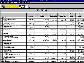 |
The Basic Requirements for GASB 34 are the Management Discussion and Analysis (MD&A) including basic financial statements and the basic Required Supplementary Information (RSI). Metroware GASB provides the data and summary reports necessary to meet these requirements enabling finance personnel to complete the notes describing the MD&A. The MD&A provides the reader with a synopsis of the financial statement with tabular data, charts, graphs and maps completing the RSI. The GIS provides the charts, graphs and maps, which are ideal backup information for the reports.
The GASB Government Financial Statements focus on measurement and are based on accounting. This includes capital assets, which may and should become an integral part of the geodatabase. The capitalization of interest is one of the more exciting components of the GASB 34 standards. The newly adopted 'Modified Approach' to asset depreciation allows costing of certain interest and associated activities that were previously depreciated to maturity. The flexibility of the Modified Approach gives governmental entities an advantage in calculating the value of infrastructure and allows for transparency in maintenance in upkeep of public property. The ease of the Modified Approach is applicable to the development and preparation of impact fees. The costs associated with the maintenance of assets in excellent to good condition can be added to the depreciation of the infrastructure or simply calculated as an expense. These data are included in the presentation in the GASB 34 Statement of Net Assets.
The required Reporting Infrastructure Assets, is easily handled by Esri and metroware GASB. The program provides all GASB calculations and prepares each report. It is designed for use by accounting firms and governmental agencies as well as planning, public works and utilities. It provides complete infrastructure and facility development and management as well as fiscal constraints and opportunities. metroware provides the programs for calculating depreciation, calculating estimated useful lives and the GASB composite methods.
Using metroware GASB with Esri GIS ArcInfo, ArcFM and ArcView provides the physical and fiscal base for the 'Modified Approach' to asset depreciation and management. The Modified Approach to depreciation allows the governmental agency to use costs expensed versus costs capitalized. The GASB Asset Management System allows for both the GASB fiscal asset management and provides physical asset management, which exceeds the GASB requirement for capitalization. The condition of the asset is produced by metroware GASB as well as the required reports.
The metroware GASB Statement of Net Assets summarizes all infrastructure and facilities as well as cash, bank accounts, investments, other capital, investment and liquid assets. The program has tables and sub-tables (calculation and disaggregate tables) that provide an electronic and paper path to the final required reports. These reports include the Net Assets, Restricted Net Assets and Unrestricted Net Assets. The Statement of Activities includes all expenses including; direct, indirect and overhead, and depreciation expense as well as interest expense. Expenses for bonds, loans and interest related to allowable capital development will be moved into capital assets upon maturity under the 'Modified Approach'.
The metroware GASB software accounts for Revenues by Classification as Program or General Revenues as a standard accounting method and reporting. The metroware package becomes more robust in revenues when GIS is applied to charges for services (by location, e.g. utility billing, permit fees, business licenses, etc.), fines and forfeitures (by occurrence location or address), grants and contributions (by location for capital related activities), taxes (Property by Location), (Sales by General Location and Standard Codes) special assessments (by location, benefit or service area).
The metroware package uses the data gathered by GASB with analytic routines to not only gather impact fees and exactions amounts, but uses the data gathered in capital improvements to update the impact fee or exactions, and calculate new fees at regular intervals as well as providing GASB reporting. It gathers and reports permit fees, improvement assessment and fees by location.
GASB GIS Applications
The GASB part of the program is very straightforward and easy. Adding the power of GIS brings normally unexciting accounting and finance to a new level. GASB 34, with GIS, enables users with many new applications. As shown in the following City of Phoenix application, service areas use the same data to calculate Impact Fees Planning. The data may quickly be aggregated to the entire City for summary, GASB or other reporting. In the same respect the data are available at basic levels: water and wastewater level of elbows, T's, manholes and valves up to reduction valves, reservoirs, wells and treatment plants. All of these data are available in ArcInfo, ArcFM and ArcView. The metroware programs import cost data for capital improvements, maintenance and operations.
After a few years of operation management, finance, planning, public works and utilities will begin to use true virtual and simulated planning with design scenarios and alternative costs. The power of metroware goes far beyond GASB 34 reporting. It is an Enterprise Internet-Intranet that enables management from executives to operational staff with informed status on programs and projects with costs, timelines and adherence to schedules. With powerful programs such as ArcFM, metroware analyses can be made 'on-the-fly' for new development master plans with alternatives and design scenarios. Even before engineering design plans are prepared, accurate cost estimates can be made using aggregate development infrastructure design based on industrial codes and residential equivalence usage. Governmental infrastructure demand and cost as well as developer ('on-site' and 'off-site') development costs are included in the models. Simply change the residential, commercial or industrial uses and applicable densities scenarios and the models recalculate.
Our sister firm developed and has working systems in place using the base enterprise management system for the aerospace industry with great success. We have used the basic programming to develop the governmental applications, which are designed to meet specific needs of local, state and national governmental agencies. The Enterprise Governmental Program Management (EGPM) system is a top down and bottom up set of JAVA programs. Departments, bureaus and sections have a complete track for each project, such as a new subdivision's development impact on planning, public works and utilities and can obtain current information on the development of government-related 'off-site' utility trunk lines, surface transportation, and other infrastructure and utility development as well as the developer associated 'on-site' activities. Departmental and Chief Executives can follow all activities from new construction, maintenance and operations by project or jobs. Problem areas can be addressed by Internet-Intranet conferencing between all responsible parties. Construction areas with associated disruption can be placed on the Internet with map locations and in the case of street construction with alternative routes.
Projects and programs can be micro-managed by supervisors and macro-managed by executives while keeping the public informed of disruptions and inconveniences with estimated duration. Finally, progress of projects can be provided over the Internet, providing both elected officials and the general public with needed answers.