Seann Reed1, Stephen King2, Victor Koren1, Michael Smith1, Ziya Zhang1, and David Wang1
1- National Weather Service Office of Hydrologic Development
2- National Weather Service Northwest River Forecast Center
National Weather Service (NWS) River Forecast Centers (RFCs) frequently use the Snow-17 and the Sacramento Soil Moisture Accounting (SAC-SMA) models to assist with flood forecasting. Although these models were developed using physical reasoning, they are conceptual models for which parameters cannot be measured directly in the field. The most accurate parameter estimates are still derived through calibration against observed streamflow; however, the use of GIS data can also help. An ArcView application called the Calibration Assistance Program (CAP) has been developed to extract useful information from soil property, forest cover, satellite snow cover, rainfall climatology, and potential evaporation data layers.
INTRODUCTION
Thirteen National Weather Service River Forecast Centers (RFCs) in the United States are responsible for producing both short and long-term river flow forecasts. There are currently about 4,000 forecast points in the United States, some along the main stems of large rivers and others along tributaries. To produce point forecasts, major river basins are typically subdivided into basins ranging in size from 300 - 5000 km2. Lumped rainfall-runoff and snow melt (where necessary) models are typically applied to each basin, and the forecasted flows at basin outlets are routed through the river network to downstream forecast points.
Two conceptual watershed models are commonly used to simulate runoff in each basin modeled: Snow-17 (Anderson, 1973) for snow accumulation and ablation and the Sacramento Soil Moisture Accounting Model (SAC-SMA) (Burnash et al., 1973) for translating rain-plus-snowmelt into runoff. Model calibration is essential to the successful application of these conceptual watershed models.
Calibration of conceptual models at RFCs is an ongoing process. There remain a number of basins in the United States where conceptual models have not been applied, but where application of these models may provide future benefits in forecasting. Model calibrations may be needed when an RFC adds a new forecast point or when there is a transition to a newer model technology. For instance, many RFCs have moved away from the empirical Antecedent Precipitation Index (API) type model (NWSRFS, 2001, II.3) in favor of the SAC-SMA conceptual model. A significant advantage of continuous, conceptual models over event API models is that they can be used for long term hydrologic forecasts (weeks to months in advance). Long term forecasts are valuable to water managers dealing with a wide variety of issues including reservoir regulation, hydro-power generation, navigation, and Endangered Species Act implementation. Additional re-calibration needs may arise if there are changes to basin land use or significant changes in the operational rain gage network over time.
Preparing a properly calibrated hydrologic model for river forecasting involves significant effort. Basin calibration requires (1) data preparation, (2) derivation of initial estimates for model parameters, and (3) manual or automatic calibration or both using observed streamflow data to refine model parameter estimates.
The Calibration Assistance Program (CAP) is an application designed to assist the calibrator in deriving initial parameter estimates. The ArcView extension (AvCAP) described in this paper replaces an older GRASS-based (USACERL, 1983) application. In addition to maintaining equivalent functionality to the old CAP, the new application includes enhanced functionality and new underlying data sets. The development of AvCAP focuses only on aspects of calibration that require GIS capabilities. The numerous other steps in the calibration process are currently supported by other programs in the National Weather Service River Forecast System (NWSRFS, 2001). Table 1 lists programs used to help with various aspects of calibration.
Table 1. Programs Used During Model Calibration
| Program Name | Description |
| Calibration Assistance Program (CAP, AvCAP) | This paper |
| Integrated Hydrologic Automated Basin Boundary System (IHABBS) | Delineate basin boundaries and compute drainage areas. Also includes tools to assist in deriving synthetic unit hydrographs. Link to web documentation. |
| Historical Data Browser (HDB) | Locate data stations; retrieve descriptive station information, period of record, brief statistical summaries, etc.; extract data for use in other applications |
| Precipitation Preliminary Processing (PXPP) | Use for station consistency checks; compute mean monthly station values; replace missing data |
| Interactive Double Mass Analysis (IDMA) | Graphical assistance for determining when consistency corrections are required |
| Mean areal precipitation (MAP), mean areal precipitation from NEXRAD fields (MAPX), Mean areal temperature (MAT), and Mean areal potential evaporations (MAPE) | Compute time series of basin mean values for various forcings. |
| Manual Calibration Program (MCP), Interactive Calibration Program (ICP) | ICP provides and interface for viewing model states, outputs, and flow hydrographs; ICP runs MCP with user specified parameter adjustments |
| Parameter Optimization Program (OPT) | Automatic parameter optimization program |
The remainder of this paper is split into three main sections: (1) a description of the current capabilities of AvCAP, with emphasis on how information derived from AvCAP is used in the SNOW-17 and SAC-SMA models, (2) a brief description of the key computational features and GUI components not discussed in section 1, and (3) concluding remarks and possible future directions.
DERIVING MODEL PARAMETERS USING AvCAP
Pre-processed data layers delivered with the software are a unique feature of AvCAP. Data delivered with AvCAP can be displayed and queried using standard ArcView and Spatial Analyst functionality. In addition, there are custom tools to do the following tasks:
Before elaborating on the AvCAP functionality, a summary of the key data sets that support AvCAP functions is provided in Table 2. These data were collected from several sources, as indicated in Column 4 of Table 2. Several of these data sets are described further in the discussions below.
Table 2 Data Sets Used by AvCAP
| Data Name | Description | Format | Data Source |
| Dem | 400 -m digital elevation model | Arc/Info Grid | NOHRSC 15 arc-second data projected into Albers, NOHRSC created the 15 arc-second DEM by resampling USGS 3 arc-second DEM data (also known as 1:250K data or 1 degree quadrangle data) |
| For_pct | Percent forest cover for ~ 1 km pixels | Arc/Info Grid | Link |
| For_type | Forest cover types for CONUS (~ 1km pixels) | Arc/Info Grid | Link |
| Pptann, pptjan, pptfeb, pptmar, etc. | PRISM Annual and monthly precipitation [inches] (~ 5 km grid cells) | Arc/Info Grid | Link |
| Peann, pejan, pefeb, pemar, etc | Annual and monthly potential evaporation [inches] (~ 10 km grid cells) | Arc/Info Grid | Koren et al. (1998) |
| adjjan, adjfeb,
adjmar, etc. |
PE adjustment grids (~ 10 km grid cells) | Arc/Info Grid | Koren et al. (1998) |
| SAC-SMA Parameter Grids | 11 grids (1 km resolution) | Arc/Info Grid | Koren et al. (2000); Duan et al. (2001) |
| soil depth, soil texture, and hydrologic soil group grids | grids (1 km resolution), texture (11 layers) and hydrologic soil group grids have multiple values assigned to each cell | Arc/Info Grid | Link |
| Snow cover grids | Remote sensing images from NOHRSC indicating snow, no snow, or cloud cover for specific days and geographic windows. Data are from 1990 - 1995 | Arc/Info Grid | NOHRSC CD-ROM received at OHD July 8, 2000 |
| Windows.shp | Windows defining the spatial extent of snow cover grids | Polygon Shapefile | Created at OHD from images on NOHRSC CD-ROM |
| Bsns_xxp.shp | RFC basin boundary Shapefile. | Polygon Shapefile | Link |
| Statekey.shp | State boundaries -- used for reference only. | Polygon Shapefile | USGS |
| Rfcbound.shp | RFC boundary or buffered RFC boundary for reference | Polygon Shapefile | Link |
| Rf1.shp | EPA's river reach file 1 (RF1) | PolyLine Shapefile | RF1 files were edited by NOHRSC for use in IHABBs; at HL, files were imported into Arc/Info format and then converted to Shapefiles; further editing was done to ensure that streams in coastal areas extend past the edge of the DEM and into an ocean or great lake |
Snow Model Parameters
Basin Subdivision with the Assistance of Snow Cover and Forest Type Analysis
In mountainous basins with significant snowfall, it is often useful to divide a basin into two or more elevation zones for modeling. This helps to capture variations in hydrometeorology and basin hydrology that are highly correlated with elevation. In a basin subdivided into three elevation zones, the highest zone might be characterized by significant spring snowmelt contribution to runoff in all years, while the middle zone may only contribute significant spring snowmelt during years with above average snow accumulation, and the lowest zone might be an area where most of the precipitation falls as rain. A zonal subdivision may also attempt to capture variation in basin characteristics such as landcover, landuse, soil type, slope, and drainage density.
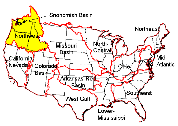
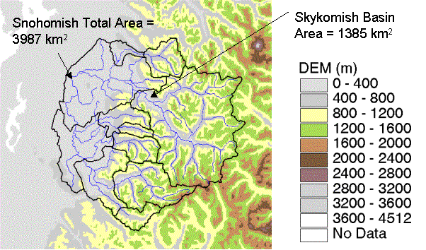
Figure 1c shows a three zone division for the headwaters of the Skykomish River. The zones were defined by the NWS Northwest River Forecast Center (NWRFC -- Figure 1a) to provide hydrologic forecasts at USGS steamflow gage 12134500 (Skykomish River near Gold Bar, WA). The Skykomish River is a tributary of the Snohomish River shown in Figure 1b and drains out the Cascade Mountains into western Washington. The Skykomish Basin will be used to illustrate examples throughout this paper. Elevations in the Skykomish Basin range from 96 m to 2267 m and the elevation breaks selected for zone subdivision are 610 m and 1067 m. An important distinction should be made between the division of headwater basin such as the Skykomish River Basin into elevation zones and the division of a larger river basin like the Snohomish into subbasins for modeling. The division of larger river basins into subbasins for modeling involves an entirely different set of criteria, which are not discussed here.
(a)
(b)
(c)
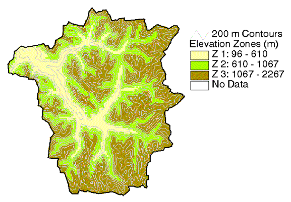
Figure 1. (a) Location of the Northwest River Forecast Center (NWRFC), one of 13 River Forecast Centers in the United States, (b) Snohomish River Basin, and (c) Elevation Zones for Skykomish River Basin above Gold Bar, WA
Dividing a basin into elevation zones for modeling is a subjective procedure.
Satellite snow cover images and forest type information available through
AvCAP are intended to help in defining elevation zones. One suggested procedure
for determining a useful separating elevation for the upper zone is to
(1) use satellite snow cover images from a number of dates in conjunction
with elevation data to determine average snowline elevations for these
dates, (2) label runoff hydrographs with these elevation values, and (3)
determine the elevation above which significant snowmelt occurs in all
but the years with very small snow accumulation (Advanced NWSRFS Calibration
Workshop, 2000). With snow cover and DEM data loaded by AvCAP, representative
elevation values of DEM cells on the border of snow cover can be determined
manually by using the standard Spatial Analyst ![]() tool,
however, this approach may become tedious. An alternative is to use the
Spatial Analyst contouring function to create elevation contours that can
be overlaid on the snow images.
tool,
however, this approach may become tedious. An alternative is to use the
Spatial Analyst contouring function to create elevation contours that can
be overlaid on the snow images.
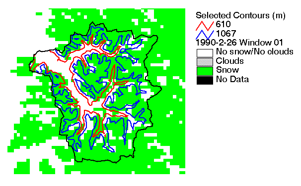
Example elevation zones and contours overlaid on satellite snow cover images are shown in Figure 2 for two dates in 1990. In Figure 2a from February 26, 1990, 82% of the upper zone is covered with snow, 67% of the middle zone, and 29% of the lower zone. The same values for June 21, 1990, (Figure 2b) are 40%, 24%, and 7% respectively. Due to the coarseness of the satellite snow cover images and the far from perfect correlation between elevation and snow cover in this basin, estimating typical snowline elevations from this satellite data remains somewhat subjective.
(a)
(b)
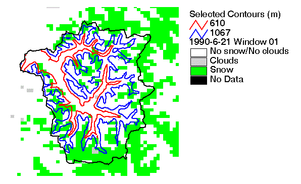
Figure 2. Satellite snow cover for (a) February 26, 1990, and (b) June 21, 1990. Selected contours correspond to elevation zones from Figure 1c.
In AvCAP, the CAP à Snow Data menu option facilitates the process of viewing snow cover images by automatic loading and setting legends for the historical snow cover images developed at the National Operational Hydrologic Remote Sensing Center (NOHRSC). Currently only a limited period of historical images from 1990 � 1995 are stored in the AvCAP database, a limiting factor when there is a need to assess snow coverage in years with high, medium, and low snowfall amounts. Future modifications to AvCAP should make it easier for RFCs to incorporate new data into this database.
Forest cover type may also be a useful indicator of climate regime and hence a useful separation level for dividing a basin into zones. Forest types shown in Figure 3 indicate a good correlation with the zone definitions in the Skykomish Basin. The upper zone is dominated by Fir-spruce, the middle zone is a mixture of Douglas-fir, Fir-spruce, and Ponderosa Pine, and the lower zone is dominated by Douglas-fir. Forest type and forest percent grids delivered with AvCAP were obtained from NOHRSC, but the data set was originally created at the USDA Southern Forest Experiment Station (Zhu and Evans, 1994). Using the Zhu and Evans (1994) 1 km percent forest cover and forest type grids, AvCAP computes the percent forest cover in each basin and zone of interest, as well as the distribution of the percent forested area covered by each forest type. Forest type percentages for the Skykomish Basin are also shown in Figure 3.
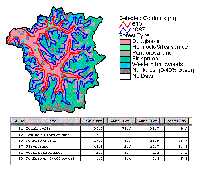
Figure 3. Forest Types in the Skykomish River Basin
Other Uses of Forest Data
Another possible use for the forest type and forest density information accessible through AvCAP is in determining initial values for the Snow-17 model parameters MFMAX and MFMIN (Anderson, 1996). MFMAX and MFMIN are melt factors occurring on June 21 and December 21 respectively. Anderson (1996) explains that forest cover is often a good indicator of melt rates and provides suggested initial ranges for MFMAX and MFMIN based on general forest cover categories: (1) quite dense coniferous forest, (2) mixed forest -- coniferous plus open and/or deciduous, (3) predominantly deciduous, and (4) open.
The percent forest cover estimates computed by CAP may also be helpful in determining estimates for the effective forest cover (EFC) parameter that is used in the evaporation calculations during snow cover situations. The EFC parameter is essentially the percent of the basin covered by coniferous forest. When there is snow cover, evapotranspiration demand is reduced by the fraction of the basin in which there is snow cover but no forest cover.
Area-Elevation Curves
In mountainous basins, it is common for precipitation to fall in the form of snow at high elevations and as rain at lower elevations because temperature tends to decrease with elevation. The Snow-17 model allows for the computation of the basin rain-snow elevation above and below which precipitation will be typed as snow or rain, respectively. Rain-snow elevation is determined using observed temperature estimates at a station with known elevation, a user specified lapse rate, and a user specified threshold temperature (temperature separating rain from snow). To determine the percent of a basin or zone over which precipitation falls as snow and the percent of a basin over which precipitation falls as rain, a fixed area-elevation curve can be used in conjunction with the time-varying rain-snow elevation estimates.
AvCAP computes area-elevation curves for either the entire basin or a selected zone within the basin. An area-elevation curve for the upper portion of the Skykomish River Basin is shown in Figure 4. Because the capabilities of the ArcView Chart type document are fairly limited, AvCAP implements X-Y plots (area-elevation and precipitation-elevation curves) using a custom document type called CAPGraph based on the ArcView View GUI. Data points to construct the area-elevation curve (black triangles) are determined by dividing the basin into equal intervals and then computing the mean elevation in that interval. The user has control over the number of intervals to use. The green triangles represent the elevation values at the 10th, 50th, and 90th percentiles of the drainage area.
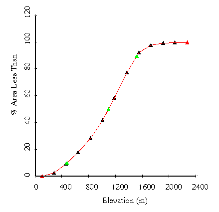
Figure 4. Area-elevation Curve for the Skykomish River Basin
A user has the option to export area-elevation curve data in an ASCII format that can be used directly as input to the Snow-17 model. In addition to this option, there are several other noteworthy Buttons and Tools available when a CAPGraph document is being viewed. These features are summarized in Table 3.
Table 3. Buttons and Tools Available from the CAPGraph GUI
| Button | Function |
| Displays an x-y coordinate list of the points displayed on the plot. This list can be copied and pasted to a text editor. | |
| Write area-elevation data to an ASCII format readable by Snow 17. | |
| Statistics: Reports the elevation values below which 10%, 50%, and 90% of the basin lies. | |
| Standard Tools borrowed from the ArcView View GUI. These tools can be used to add text to the CAPGraph window; draw points, lines or polygons; select, move, or delete graphic objects (note: everything shown in the CAPGraph window is a graphic object); pan; zoom in; and zoom out. | |
| Return the graph coordinates (X,Y) of any mouse location clicked in the CAPGraph window. These coordinates are different from the "View" coordinates displayed on the right portion of the ArcView Toolbar. |
Precipitation Analysis
An important component of hydrologic model calibration is preparation of a mean areal precipitation (MAP) time series. When a basin is subdivided into elevation zones, an MAP time series must be created for each zone. In mountainous areas, long term mean rainfall amounts my vary significantly over short distances due to the effects of elevation and aspect relative to typical storm tracks. Thus, the use of a weighting scheme that depends only on geographic location (e.g. Thiessen polygons) is inappropriate.
To derive MAP estimates in mountainous areas, it is common to first assign relative station weights based on knowledge of the relative importance of location versus elevation in how well stations are correlated with one another. Once relative weights are assigned, the actual station weights are computed in such a way that the long term mean precipitation predicted by applying the station weights to gaged time series is equal to the long term mean precipitation estimated for the basin. Long term mean basin precipitation is typically determined using an isohyetal map; however, values derived from the isohyetal map may need adjustment to reflect the period of record covered by the available station data. In addition, mean precipitation estimates derived from isohyetal maps are typically verified using regional water balance analysis, sometimes resulting in precipitation adjustments to produce regionally consistent evaporation estimates. Ensuring that precipitation means computed with station weights are equal to the long term precipitation means is important in efforts to minimize bias between MAPs computed for calibration and MAPs computed for operational forecasting.
AvCAP simply provides estimates of the long-term basin mean for annual, monthly, and seasonal precipitation using gridded PRISM data (PRISM, 2001). In this way, the national PRISM rainfall grids serve as the isohyetal maps in AvCAP. Computed values of seasonal (winter versus summer) long-term means are used when winter time orographic effects make elevation a more important factor in determining relative station correlations than during summer convective storms. In these situations, different station weights may be assigned during winter and summer seasons.
Currently, the X-Y precipitation-elevation plotting capability in AvCAP is limited to using PRISM precipitation grids and not station precipitation data. An example annual precipitation-elevation graph produced by AvCAP is shown in Figure 5. Although not used directly to estimate model parameters, a graph of this type is helpful in selecting stations for analysis and assigning station weights. Knowing that elevation plays a key role in defining precipitation variability for a particular basin, a calibrator might place more weight on a high elevation station to define the precipitation MAP for an upper zone, even if the station lies outside the basin boundary. The algorithm to derive the data points shown in Figure 5 is to slice the basin into a user defined number of elevation intervals, compute an average precipitation and elevation within each interval, and plot the resulting set of data pairs. For reference, the red triangles are plotted using the lowest precipitation and elevation values and the highest elevation and precipitation values in the basin. The precipitation-elevation line does not necessarily pass through these points because the high elevation location may not be exactly the same as the high precipitation location.
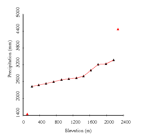
Figure 5. Precipitation-Elevation Curve for the Skykomish River Basin
One area where a little bit of additional AvCAP automation might save substantial time is in assigning relative station weights. Assigning relative station weights is still a subjective process; however, customized tools to display station anomalies and station correlations would simplify this process. Another useful precipitation related AvCAP addition would be to include station data in precipitation-elevation plots like that shown in Figure 5 and to provide the option to produce seasonal precipitation-elevation plots.
Parameters Used in the Sacramento Model (SAC-SMA)
The AvCAP database includes several useful parameter grids covering the conterminous United States. These grids include 12 mean monthly and a mean annual potential evaporation (PE) grids, 12 PE adjustment factor grids, and 11 Sacramento model parameter grids. The AvCAP function that uses these grids simply computes mean, maximum, and minimum values of these parameters for basins and/or zones of interest, and presents the results to the user in a tabular format.
Koren et al. (1998) used information from seasonal and annual free water surface evaporation maps in NOAA Technical Report 33 (Farnsworth et al., 1982) and mean monthly station data from NOAA Technical Report 34 (Farnsworth and Thompson, 1982) to derive parameters for an equation that predicts seasonal variability of mean daily PE. These parameters were used to derive the monthly PE grids delivered with AvCAP. Summing the monthly grids yield results consistent with the annual and seasonal maps in NOAA Technical Report 33.
In application of the SAC-SMA model, it is common to multiply PE by a potential evaporation adjustment factor to account for seasonal variations in vegetation activity. The product of the PE and PE adjustment values is referred to as the PE demand. Koren et al. (1998) describe the method used to develop PE adjustment factor grids. The method uses an empirical function relating PE adjustment factors to green vegetation fraction data. This empirical relationship was developed using PE adjustment factors derived from calibration of the SAC-SMA model and monthly values of green vegetation fraction data from National Center for Environmental Prediction (NCEP) data sets (Gutman and Ignatov, 1998). Figure 6 shows the monthly values of PE, PE adjustment, and potential evapotranspiration demand computed for the Skykomish basin using AvCAP.
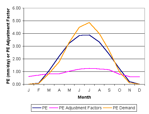
Figure 6. PE, PE Adjustments, and PE Demand for the Skykomish River Basin
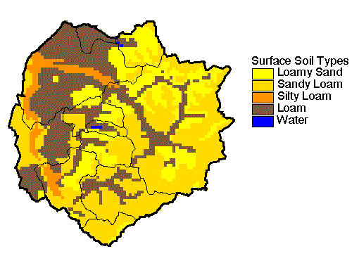
Koren et al. (2000) describe a method to estimate 11 of the SAC-SMA parameters using soil texture, soil depth, and Soil Conservation Service (SCS) hydrologic soil group data (also described in Duan et al., 2001). This method is based on the hypothesis that the SAC-SMA model parameters do correlate to physical soil properties in some way, even though these properties cannot be measured directly. The main motivation for deriving soil-based SAC-SMA parameter estimates was for use in distributed modeling research; however, the derived grids and the basic soil grids used in their derivation are provided in AvCAP as supplemental information for the calibration of lumped models. These grids show regional variations in soil properties/parameters that might be useful for a calibrator to identify regional trends in calibration parameters. A common calibration strategy is to concentrate on a group of hydrologically connected basins. Parameters derived for one basin are often a useful starting point for estimating parameters in a similar nearby basin (HRC, 1999). AvCAP computes mean values from the SAC-SMA parameter grids for selected basins or zones, which may be used as a reasonable starting point for calibration when no better estimates are available. Figure 7a shows soil texture for the upper layer in the Snohomish area, and 7b shows the SAC-SMA parameter Upper Zone Tension Water Maximum (UZTWM). As expected, there is some spatial correlation between these two maps, but the correlation is not perfect because texture information for additional soil layers, total soil depth data, and hydrologic soil group data also go into the calculation of UZTWM.
(a)
(b)
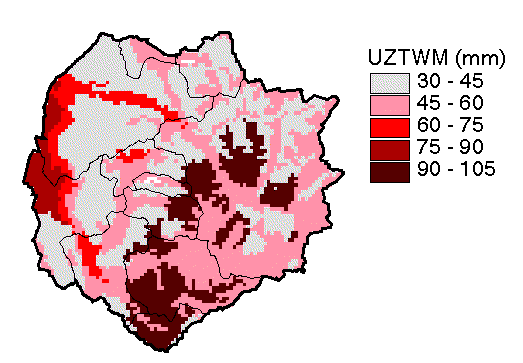
Figure 7. (a) Surface soil texture and (b) estimated UZTWM (mm) for the Snohomish area.
AVCAP COMPUTATIONAL PROCEDURES AND GUI INTERFACE COMPONENTS
AvCAP programs are written in Avenue and distributed as an ArcView Extension. The programs require ArcView 3.1 and Spatial Analyst 1.1. Nearly all of the AvCAP functionality is accessible through a "CAP" menu item that is added to the View GUI by the extension. The CAP menu is illustrated in Figure 8. A summary of the main program features is provided below. More detailed descriptions, including illustrations of the Dialogs displayed for user input are provided in the online documentation (AvCAP, 2001).
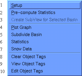
Figure 8. CAP Menu
1. Setup: The Setup item must be run to get started, but will typically only need to be run once. Setup creates a main View for analysis, loads data, and associates an object tag with the main View for data management purposes. The View object tag is a Dictionary object that stores data Theme definitions. Other programs check this Dictionary for required data inputs. The use of an object tag is preferable to a global variable because it is saved with the project and will persist into subsequent user sessions.
2. Pre-compute Statistics: The main purpose of this option is efficiency. Typically, RFCs have already defined basin boundaries for several hundred basins. These basin boundaries will not change often so it is computationally efficient to pre-compute statistics from the underlying parameter grids and store the basin results in tables. If an elevation subdivision is made for a particular basin, the actual computation of the statistics for that subdivision will be made using Item 6. With no subdivisions, Item 6 simply reads values from pre-computed data tables.
3. Create Subview for Selected Basin: Setup generates an RFCView intended for viewing multiple basins and regional parameter trends. More detailed analysis of individual basins is initiated using the Create Subview for Selected Basin option. This creates a new View in which localized (clipped) data sets (e.g. basin boundary, streams, forest types, elevation, etc.) are viewed. Items 4-7 are only accessible to the user when a Subview is the active ArcView document.
4. Plot Graph: This item gives the user the option to plot an area-elevation curve or a PRISM precipitation-elevation curve. If a basin has been subdivided, there is an option to plot either curve for the entire basin or a selected zone. Because the capabilities of the ArcView Chart type document are fairly limited, AvCAP implements X-Y plots (area-elevation and precipitation-elevation curves) using a custom document type called CAPGraph based on the ArcView View GUI. Key features of this DocGUI were described above in relation to parameter estimation for Snow-17.
5. Subdivide Basin: This item provides a Dialog allowing the user to select elevation intervals for subdivision. A grid and polygon layer defining the zones are created and added to the user's Subview.
6. Statistics: Provides a Dialog that allows the user to select which statistics to compute and display for the basin of interest.
7. Snow Data: Provides a Dialog listing snow cover images that are available for the area of interest. Selected images are automatically loaded and displayed using a pre-defined legend.
CONCLUSIONS AND FUTURE PLANS
AvCAP provides assistance to hydrologists in managing and examining spatial data sets and in estimating initial parameters for the Snow-17 and SAC-SMA conceptual models. AvCAP is intended to be used in conjunction with an existing suite of NWS calibration procedures.
A key aspect of AvCAP is the compilation of the supporting data sets listed in Table 2. Most of these data sets cover the conterminous United States, although some are relatively coarse in resolution. Use of the flexible and widely used ArcView environment allows users to incorporate their own more detailed data if available for an area of interest.
AvCAP is still in the early stages of development, and the intent is to continue exploring ways that GIS technology can assist with both current and future calibration methodologies. Several possible enhancements to AvCAP have been suggested in this paper, and there are others being considered. Linkage to other NWSRFS calibration programs is one area where small AvCAP enhancements may yield significant simplifications to the overall calibration process. For example, automatic mapping of climate stations selected using Historical Data Browser (HDB) and display of mean monthly and annual station statistics as well as station correlation values from the Preliminary Precipitation Processor (PXPP) would be very useful functions. The formal requirements process now in place at NWS may help to identify aspects of the calibration process which need the most improvement.
REFERENCES
Advanced NWSRFS Calibration Workshop (2000). Held at North Central River Forecast Center (NCRFC), July 17-21, 2000.
Anderson, E.A. (Nov. 1973). "National Weather Service River Forecast System -- Snow Accumulation and Ablation Model," NOAA Technical Memorandum NWS Hydro-17, Silver Spring, MD.
Anderson, E. (1996). "Initial Parameter Values for the Snow Accumulation and Ablation Model," NWSRFS User's Manual IV.2.2,<http://hsp.nws.noaa.gov/oh/hrl/nwsrfs/users_manual/htm/formats.htm, 2001.
AvCAP (2001). "CAP User Manual (ArcView Prototype v. 1.1)," <http://hsp.nws.noaa.gov/oh/hrl/calb/cap/capmanual.html
Burnash, R.J., R.L. Ferral, and R.A. McGuire (1973). A Generalized Streamflow Simulation System Conceptual Modeling for Digital Computers, U.S. Department of Commerce National Weather Service and State of California Department of Water Resources.
Duan, Q., J. Schaake, and V. Koren (2001). "A Priori Estimation of Land Surface Model Parameters," Land Surface Hydrology, Meteorology, and Climate: Observations and Modeling, Water Science and Application Volume 3, 77-94.
Farnsworth, R.K., and E.S. Thompson (1982) "Mean Monthly, Seasonal, and Annual Pan Evaporation for the United States," NOAA Technical Report NWS 34, Washington, D.C., 82 pp.
Farnsworth, R.K., E.S. Thompson, and E.L. Peck (1982). "Evaporation Atlas for the Contiguous 48 United States," NOAA Technical Report NWS 33, Washington, D.C.
Gutman, G., and A. Ignatov (1998). "The derivation of the green vegetation fraction from NOAA/AVHRR data for use in numerical weather prediction models," Int. J. Remote Sensing, 19, 8, 1533-1543.
HRC - Hydrologic Research Center (May 1999). "Calibration of the Sacramento Soil Moisture Accounting Model," Video Series produced for the National Weather Service.
Koren, V., J. Schaake, Q. Duan, M. Smith, and S. Cong, Unpublished Report: "PET Upgrades to NWSRFS, Project Plan," unpublished report, August 13, 1998.
Koren, V.I., M. Smith, D. Wang, Z. Zhang (2000). "Use of Soil Property Data in the Derivation of Conceptual Rainfall-Runoff Model Parameters," 80th Annual Meeting of the AMS, Long Beach, CA, January 10-14, 2000.
NWSRFS User's Manual Documentation (June, 2001). <http://hsp.nws.noaa.gov/oh/hrl/nwsrfs/users_manual/htm/formats.htm
PRISM (2001). <http://www.ocs.orst.edu/prism/prism_new.html.
USACERL, U.S. Army Corps of Engineers Construction Engineering Research Laboratory (1983). GRASS 4.1 User's Reference Manual, USACERL, Champaign, IL, 556 pp.
Zhu, Z., and D.L. Evans (1994). "U.S. Forest Types and Predicted Percent Forest Cover from AVHRR Data," Photogrammetric Engineering and Remote Sensing, 60, 5, pp. 525-531.
Corresponding Author:
Dr. Seann M. Reed
Research Hydrologist
National Weather Service Office of Hydrologic Development
1325 East-West Highway w/ OHD1
Silver Spring, MD 20877
(301) 713-0640 x161
seann.reed@noaa.gov