Habitat use and home-range size of white-tailed deer have been the subject of numerous biological investigations (e.g., Rongstad and Tester 1969; Marchinton and Hirth 1984; Tierson et al. 1985; Dusek et al. 1988; Beier and McCullough 1990). Beier and McCullough (1990) pointed out that white-tailed deer use available habitats to satisfy basic requirements for food, rumination, movement, social interactions, and rest. Because of the diversity of vegetational communities throughout the range of the white-tailed deer and the different responses of vegetation to various manipulations, applied management of vegetation to meet the needs of this species varies geographically (Smith and Coggin 1984). However, an understanding of the variation among individual deer in regard to the composition of habitat within the home range that is utilized (seasonally and annually) to meet critical needs for life and reproduction is unclear and in need of study. Such information could have strong management implications.
Home range has been defined as the area traversed on an annual basis by an individual in its normal activities of food gathering, mating, and caring for young (Burt 1943). Marchinton and Hirth (1984) and Smith (1991) summarized much of the available literature relating to home ranges of white-tailed deer. Movements of white-tailed deer are known to vary seasonally and annually in regard to habitat use (see Beier and McCullough 1990; Smith 1991) as well as between the sexes (Kroll 1994). Presently, radio-telemetry procedures and geographic information systems (GIS) provide a means for overlaying home-range patterns onto habitat maps for assessing habitat composition occurring within home ranges of individual animals. Because white-tailed deer are highly adaptable and occupy a variety of habitat types (Hesselton and Hesselton 1982; Smith and Coggin 1984), they make an interesting model for assessing habitat composition at the intraspecific level. At this time, it is uncertain if species with a wide tolerance for habitat, such as white-tailed deer, have commonalities as to the amount of specific types of habitat encompassed within the home range and if general habitat variables can be used to predict the occurrence of the species in selected areas.
The purpose of the paper were to determine if general habitat variables can be used to predict the occurrence of white-tailed deer in western Tennessee. This investigation was designed to elucidate broad trends in habitat-home range relationships and should provide new insight relating to the management of habitat for white-tailed deer.
STUDY AREAThe investigation was conducted on the Milan Army Ammunition Plant in Carroll and Gibson counties, Tennessee. This site was ca. 9,080 ha and consisted of primarily agricultural crops, managed forest, open ground, and pasture. Land use in surrounding areas, in general, was comparable to that of the study site. Topography of the uplands consisted of gently rolling hills and scattered erosional gullies, while bottomlands were primarily level. Water included several streams and ponds. Controlled hunting was allowed from September through January.
MATERIALS AND METHODS
During 1992 to 1997, adult white-tailed deer were captured and radiotracked to obtain estimates of home range. A few animals were captured with rocket-nets (Hawkins et al. 1968), but most where taken by darting with tranquilizer darts equipped with a radiotransmitter (Lovett and Hill 1977). Animals were fitted with radiocollars, each with an individual frequency ranging from 150.520 MHz to 151.749 MHz (Wildlife Materials, Inc., Carbondale, IL; Advanced Telemetry Systems, Inc. , Isanti, MN). Collars were equipped with a motion switch to determine if the animal was bedded or moving. Numbered cattle-ear tags were attached to the collars aiding visual identification. Biological seasons were established as: post-rut (1 January - 30 April); fawning (1 May - 31 July); pre-rut (1 August - 15 October); and rut (16 October - 31 December). Locations were determined by radio-telemetry fixes or by visual identification.
The GIS data layers developed in this study included coniferous forest (cedar and pine), new-cut hardwood forest (<10 years -old) , old-cut hardwood forest (>10 years old), selected-cut pine forest (pines that had been thinned leaving an open forest of mixed pine and hardwoods), clear-cut pine forest (all trees removed), crop field, pasture, and wetland, location of deer (determined from radio-telemetry procedures), and home range of deer. Because the northern portion of the site consisted of a much greater amount of agricultural lands than did the southern part and the southern section consisted of a much greater amount of forested lands than did the northern part, the study site was divided into a northern and southern section for modeling purposes. For examination of habitat composition within individual home ranges, habitat was grouped into 5 types: coniferous forest (cedar and pine), agricultural field (any field planted in an agricultural crop), hardwood forest (new-cut and old-cut hardwoods combined), open ground (associated with industrial and maintained areas), and pasture/old field (pasture).
Using ARC/INFO and ARC/VIEW GIS, the 95% and 50% minimum convex polygons for animals were over laid with the habitat coverage. Percentage of each habitat within the home range of individuals was determined. To evaluate the probability of white-tailed deer occurrence on the site, a habitat model was developed. The model was constructed following logistic regression procedures outlined by Chou (1992). This model applied variables recorded in the GIS data (coniferous forest, new-cut hardwood forest, old-cut hardwood forest, selected-cut pine forest, clear-cut pine forest, crop field, pasture, wetland, and radio-telemetty locations). Home ranges were used to represent the spatial use of habitat by deer; however, individual locations for deer rather than home ranges were used to estimate the proximity of deer to each variable represented in the GIS data layers. Random points, recorded from outside the home ranges of all deer studied, were used to represent the random situation for model construction. Procedures identical to those used to determine locations of deer were conducted to determine distance from habitat variables to random points for comparative purposes. The probability of deer use of habitat is defined, in the model, as the likelihood for deer to occur in a given area. This probability is applied to predict future deer habitat and, therefore, probability of the occurrence of deer over the landscape. The probability of deer use of habitat is measured based on a scale between 0 and 1. A lower probability of use by deer represents a reduced likelihood of deer residing in the area; higher probability represents an increased likelihood of deer occurring in the area.
Sixty-one deer were captured (40 males, 21 females) during the study. Date of capture, tag number, age, external measurements, and transmitter frequency are recorded. During the period of tracking, 3,229 individual fixes were recorded for males and 6,928 for females.
Results of probability models are evaluated based on estimated parameters, Wald chi-square, and R and P-values for each independent variable. Overall, of the explanatory variables considered for males, distance to new-cut hardwoods, distance to selected-pine cut, and distance to pasture were the best predictors of occurrence on the northern section of the site (Figure 1); for females on this section, distance to coniferous forest, distance to new-cut hardwoods, distance to selected-pine cut, and distance to pasture were explanatory variables found to be good predictors of the occurrence of white-tailed deer. For males and females on the northern section, differences in the Percent Correct Estimation (PCE) for all models ranged from 81.68% (rutting season) to 89.15% (post-rut season) and 97.48% (post-rut season) to 99.00% (rutting season) , respectively. With sexes and seasons combined, distance to new-cut hardwood, distance to pasture, and distance to selected-pine cut were the significant predictors of the occurrence of white-tailed deer (PCE - 88.92%).
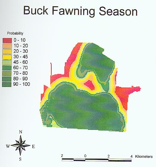
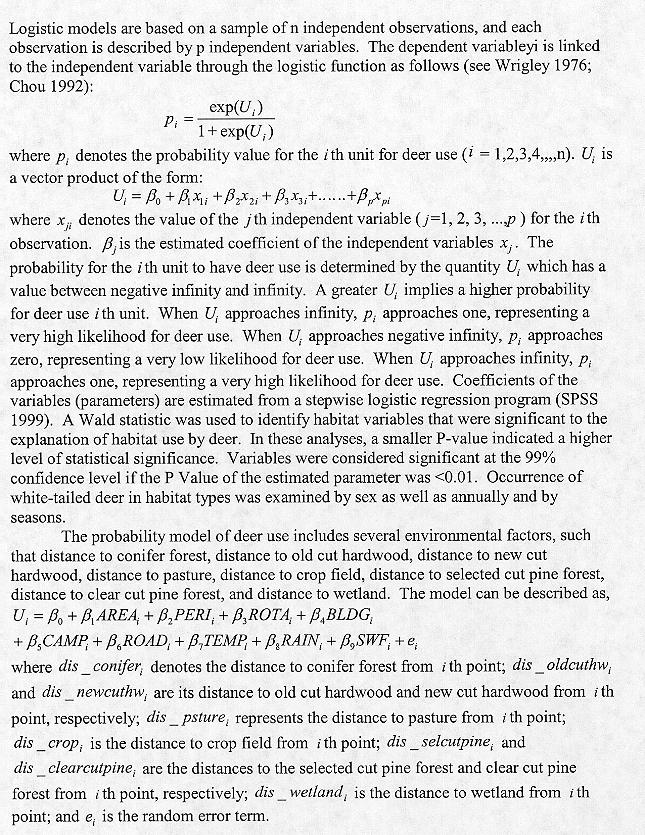
Figure1. Relative probability of habitat use for male white-tailed deer during fawning season at the northern section of the study area
For the southern section, distance to pasture and distance to selected-pine cut were the significant predicators of the occurrence of males. PCE values ranged from 86.76% (rutting season) to 95.74% (post-rut season). For females on the southern section, distance to coniferous forest, distance to new-cut hardwood, distance to clear-cut, distance to pasture, and distance to wetland were the explanatory variables best predicting the presence of white-tailed deer on the site. PCE values ranged from 86.31% (post-rut season; Figure 2) to 88.14% (rutting season). With sexes and season combined, the same four explanatory variables found to be significant for females also were found to be significant for the grouped data (PCE value = 89.20%).
Figure 2. Relative probability of habitat use for female white-tailed deer during post-rut season at the southern section of the study area
DISCUSSION
The logistic regression models explained relative habitat use for white-tailed deer based on the conditions of the study site. In the initial assessment of habitat use, several variables were examined. These preliminary analyses indicated that 7 variables (distance to coniferous forest, distance to new-cut hardwoods, distance to old-cut hardwoods, distance to selected-cut pine forest, distance to clear-cut pine forest, distance to pasture, and distance to wetland) consistently provided some level of statistical significance in predicting habitat use by white-tailed deer. Therefore, these 7 parameters were utilized in the models. As results of the present study indicated, 3 to 4 of these (distance to coniferous forest, distance to new-cut hardwoods, distance to pasture, and, occasionally, distance to wetland) usually dominated the models. These were considered among the primary forces to which white-tailed deer responded. We should note that statistical significance does not reflect cause-and-effect relationships. It may be that the variables utilized simply are correlates of true environmental factors to which white-tailed deer respond. For example, pasture makes up only a small proportion of the home range of males; however, it is useful in predicting occurrence of these animals on the landscape. This is probably best explained by the fact that deer are not attracted by the pasture but the forest or field edge that adjoins this habitat. Smith (1991) pointed out that the riparian forest serve as corridors of movement and dispersal for the species, and Williamson and Hirth (1985) noted that white-tailed deer preferred feeding near the edge of forest cover. Regardless of cause-and-effect, results of the present study indicated that a few habitat factors can be used effectively to predict the use of certain habitats by white-tailed deer at a relative high level of probability.
LITERATURE CITEDBeier, P., and D. R. McDullough. 1990. Factors influencing white-tailed deer activity patterns and habitat use. Wildlife Monographs, 109. 51pp.
Burt, H. W. 1949. Territoriality and home range concerpts as applied to mammals. Journal of Mammalogy, 24:346-352.
Byford, J. L. 1970. Movement response of white-tailed deer to changing food supplies. Proceedings of the Southeastern Association of Game and Fish Commission, 26:63-78.
Chou, Y. H. 1992. Management of wildfires with a geographic information system. International Journal of Geographic Information Systems, 6:123-140.
Hawkins, R. E. , L. D. Mortoglio, and C. G. Montgomery. 1968. Cannon-netting deer. The Journal of Wildlife Management, 32:191-195.
Lovett, J. W. , and E. P. Hill. 1977. A transmitter syringe for recovery of immobilized deer. The Journal of Wildlife Management, 41:313-315.
Marchinton, R. L. , and D. H. Hirth. 1984. Behavior. Pages 129-168 in L.K. Halls, ed. White-tailed deer ecology and management. stackpole Books, Harrisburg, Pa.
Rongstad, 0. J., and J. R. Tester. 1969. Movements and habitat use of white-tailed deer in Minnesota. The Journal of Wildlife Management, 33:366-379.
Scanlon, J. J., and M. R. Vaughn. 1985. Movements of white-tailed deer in Shenandoah National Park, Virginia. Proceedings of the Annual Conference of the Southeastern Association of Fish and Wildlife Agencies, 39:396-402.
Smith, W. P. 1991. Odocoileus virginianus. Mammalian Species, 388:1-13.
Tierson, W. C., G. F. Mattfeld, R. W. Sage, Jr., and D. f. Behrend. 1985. Seasonal movements and home ranges of white-tailed deer in the Adirondacks. The Journal of Wildlife Management, 49:364-372.
Tucker, R. L. 1981. Home range and habitat selection of white-tailed deer in east Texas. M.S. Thesis, Stephen F. Austin State University, Nacogdoches, TX.
Verm, L. J. 1973. Movements of white-tailed deer in upper Michigan. The Journal of Wildlife Management, 37:545-552.
Williamson, S. J., and D. H. Hirth. 1985. An evaluation of edge use by white-tailed deer. Wildlife Society Bulletin, 13:252-257.
Wrigley, N. 1976. An introduction to the use of logit models in geography, concepts and techniques in modern geography, Volume 10 (Norwich: Geography Abstracts).