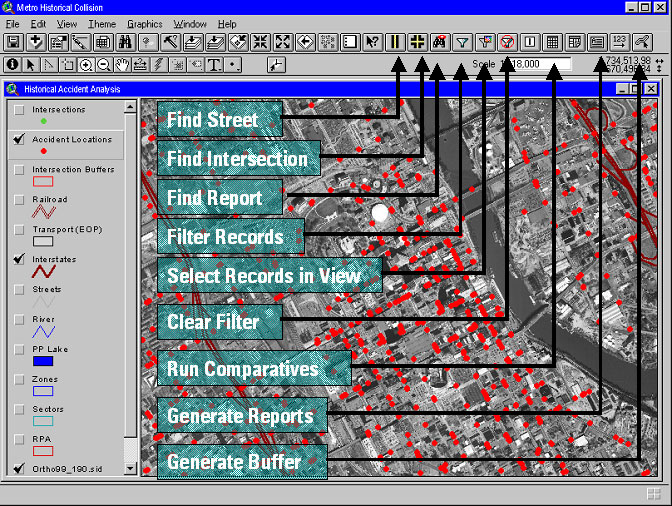
Using GIS to target traffic problems illustrates a best practice to adopt for traffic crash data systems. The analytical module allows traffic analysts (police and public works) to simply point to an intersection on the GIS map and retrieve all crashes from the three-year period in the database. The data can then be filtered by day of he week, time of day, type of crash, weather conditions, number of cars, driver impairment, etc., for further analysis.
A few examples of this type of analysis now available is:
Another advantage of an electronic GIS environment is the ability to analyze crashes that occurred at intersections along a corridor or within a district or around a special event such as a football game.
After deployment of the new software, Neel-Schaffer found that the time required to assess the safety of city intersections dropped significantly following the installation of the program. For example:
A review of accident reports for the last three years revealed the following:
Over a typical three-year period, the Metropolitan Nashville Police Department logs and analyzes more than 90,000 traffic collisions within Davidson County. The analysis of this data by both the public works and police departments is labor-intensive because data analysis is performed by hand from paper printouts of reports that are stored electronically in the police department's mainframe computer. Like many jurisdictions, information delivered to the traffic engineering staff for analysis is also in the form of monthly paper printouts, plus hard copies of the actual collision report forms. Because of the cumbersome nature of such analysis, the paper process severely limits the ability to analyze information at high-incidence intersections to determine the cause or nature of collisions and to propose corrective engineering or enforcement solutions, and trend analysis is almost nonexistent.
Another important point is that the two departments, police and public works,
look for different causality effects regarding traffic crashes. Police are more
focused on enforcement issues, while public works personnel pay more attention
to engineering and signal or sign placement. In an attempt to improve the current
system, Metro officials undertook a project to make collision reporting more
efficient and the analysis more timely.
The project consisted of three major tasks:
1. Development of an electronic data-entry application for real-time entry of
collision reports in the field by officers in the police cruisers;
2. Development of an automated database system for analysis of collision data
collected in the field at the time of the crash; and
3. Analysis of historical collision data to determine the 30 highest collision
locations within Nashville and Davidson County for more detailed engineering
analysis.
The purpose of the project was to generate custom software applications to replace the current paper-based method of both collision reporting and collision analysis. The implementation of this system will make possible the near real-time entry and analysis of collision records. In addition to the increase in time efficiency, the overall level of analytical capability will be greatly improved by allowing for enhanced manipulation of collision data. The records themselves will achieve a higher level of accuracy by eliminating many of the data-entry steps, therefore, eliminating opportunities for error. Specifically, the system will allow for electronic capture and data entry of collision information contained on the collision report and allow geospatial (or GIS, which stands for geographic information system) analysis of collision data within metropolitan Davidson County.
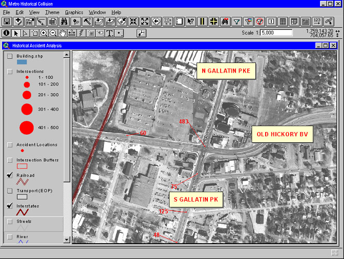
To accomplish this task, Neel-Schaffer developed a viewing and analysis application that was loaded as an extension for ArcView 3.2, and a VB-application was developed to go on laptops in the patrol cars using MapObjects 2.1. This police car application allows the officers in the field ready access to any available aerial photography and an intelligent street centerline file that allows them to quickly found intersections and accident locations.
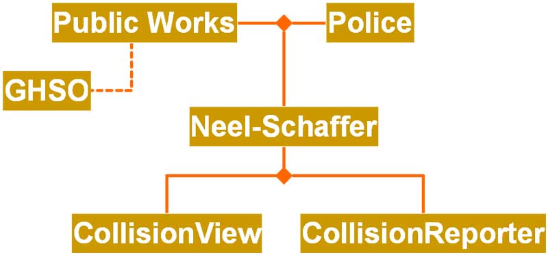
To simplify the process, Metro Nashville Police and Public Works worked with
the Tennessee
Governor's Highway Safety Office to retain Neel-Schaffer, Inc., an engineering
and planning firm to develop a custom software solution for automated collision
database reporting. The resulting software was named CollisionView™ and
enables police to log reports into computers with the data becoming readily
accessible to traffic engineers and police planners within Metro Government
using.
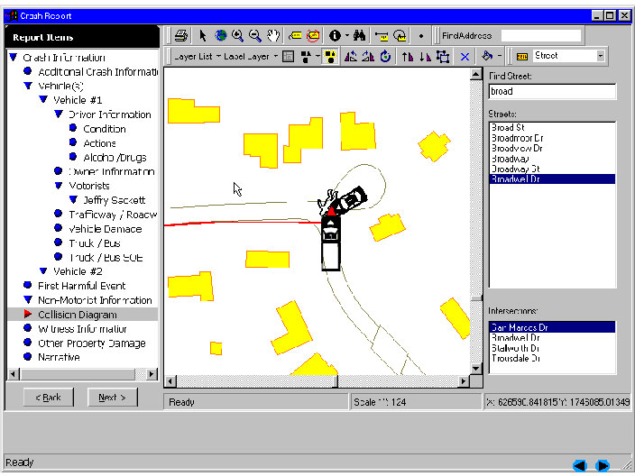
In the above illustration, Neel-Schaffer engineers created a custom font set of vehicles and other traffic symbols for use and manipulation by the officer in creation of a collision diagram. Since the template for drawing the diagram is the actual intersection exported from the GIS, the crash locations and points of impact are automatically georeferenced using the coordinate system of the city's GIS base map.
Metro officials say that the new system allows them to be more proactive in
reviewing and addressing the problems of the city's intersections. Even more
important, they can perform that analysis much more quickly than before. Jonathan
Cleghon, an engineer with Metro Nashville who worked on the project summed the
improvements up this way. "If you've got a major intersection with 50 accidents
a year, under our old system you would sit down and review 150 accidents over
a three-year period from police printouts, and you'd spend a day or more going
through filing cabinets. With the collision database, and the CollisionView™
software that was developed for us, if you wanted to know how many of those
150 accidents were the result of drunk driving, you could get the answer in
five minutes or less."
Randy F. Thompson
Vice President, Neel-Schaffer, Inc., Engineers - Planners
4205 Hillsboro Road, Suite 207
Nashville, TN 37215
615-383-8420
rthompson@neel-schaffer.com
http://www.neel-schaffer.com