This paper presents the use of GIS in a wastewater collection system master plan. The master plan evaluates the impact of 50 years of projected growth on the capacity of a collection system serving 130,000 people in eastern Iowa. Land use plans showing development in 25 year increments led to projected wastewater flows. A hydraulic model identified system inadequacies and confirmed the viability of proposed system improvements. This paper discusses incorporating data from CAD, database, spreadsheet, GIS, and paper sources; interfacing with hydraulic models; and presenting results.
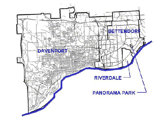
Figures 1 and 2 show the location of Davenport, Bettendorf, Riverdale, and Panorama Park, four communities in eastern Iowa along the Mississippi River. The combined population is approximately 130,000. The communities exhibited strong growth between 1900 and 1980; population losses between 1980 and 1990; and growth again between 1990 and 2000. These cities were the subject of a wastewater collection system master plan that utilized GIS.
The communities each own and operate their respective collector and trunk sewer systems. However, they share a common large-diameter riverfront interceptor sewer and water pollution control plant. Collector sewers are typically 8 to 10 inches in diameter. Trunk sewers range from 12 to 48 inches in diameter. The large-diameter riverfront interceptor ranges from 6 to 8 feet in diameter.
The water pollution control plant has primary treatment capacity of 66 million gallons per day (mgd) and secondary treatment capacity of 30 mgd. Flows in excess of primary treatment capacity are allowed to backup into the large-diameter riverfront interceptor.
Present day average dry weather flow is estimated at 22 mgd. Peak wet weather flows are greater than the 66 mgd capacity at the water pollution control plant and measurements of flow were not available.
The Wastewater Master Plan was a study that considered the next 50+ years of growth in the study area. The cities plan to approximately double the amount of developed land in the study area during this period. This projected growth will place a severe strain on the existing wastewater system. The goal of the study was to develop a capital improvements program for the cities that will solve existing capacity problems, provide guidelines for fixing isolated problems such as sewer backups, and provide capacity for projected future development. The analyses of the sewer system were performed using the Visual SWMM hydraulic modeling program.
The SWMM hydraulic model is an unsteady model originally developed by USEPA. It simulates flows in urban sanitary and storm sewer systems including gravity and pressure flow conditions. Given inputs of the sewer system and flows, it will combine and route these flows to indicate how the sewer system responds to the simulated conditions. The results are useful for identifying problem areas and designing sewers appropriately.
Base layers used in the study included streets and roads, creeks and waterways, topography, and city limits. Davenport provided these layers in ArcView shapefile format. Bettendorf provided base layers in CAD format, which we converted to ArcView shapefiles.
Other base data was obtained from the Iowa Department of Natural Resources and the Bi-State Regional Planning Commission. The Iowa DNR provided USGS Digital Raster Graphics, which are scanned-in 1:24,000 scale topographic maps, as well as a variety of vector data sets such as bedrock information. Bi-State provided aerial photographs of the area.
A variety of coordinate systems were used on the project. Davenport's base data were provided in a local coordinate system based on the Iowa State Plane coordinate system. Bettendorf's base data were provided in paper scale coordinates. Iowa DNR base data were provided in UTM Zone 15 coordinate system. Aerial photos were in Illinois State Plane coordinates.
Sewer system data for Davenport were provided in both ArcView shapefile and SWMM formats. The ArcView tabular data included only sewer and manhole identification numbers. Other sewer information including sewer lengths, diameters, and inverts were provided in SWMM format. In order to utilize the tabular information in ArcView, the SWMM data was exported in ASCII format. A spreadsheet was used to reformat the ASCII format data into dBase format. The dBase format file could then be attached to the sewer shapefiles in ArcView.
Sewer system data for Bettendorf were provided as paper maps only. The maps showed the location of all sewers and manholes relative to street locations and indicated the sewer information such as lengths, slopes, inverts, diameters, etc. These maps were simultaneously entered as graphical manhole elements in ArcView and as tabular data in a spreadsheet. An Avenue script connected the manhole locations to create a sewer shapefile. The tabular data was exported into both SWMM and dBase formats. The dBase format files were then joined to the manhole and sewer shapefiles.
Sewer system flow monitoring was performed in Bettendorf as a part of this project. Monitoring had already been performed in Davenport. The flow monitoring involved installing over 50 flow meters for 2 to 3 months in the sewer system that recorded depth and velocity. The data were analyzed to develop the current day sewer models, dry and wet weather diurnal flow curves, wet weather peaking factors, and land use flow factors.
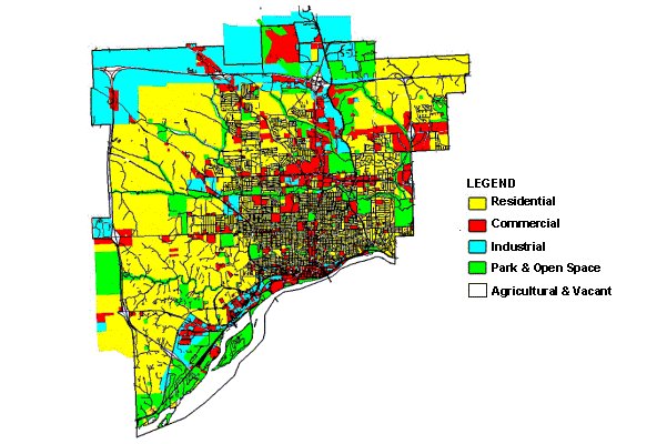
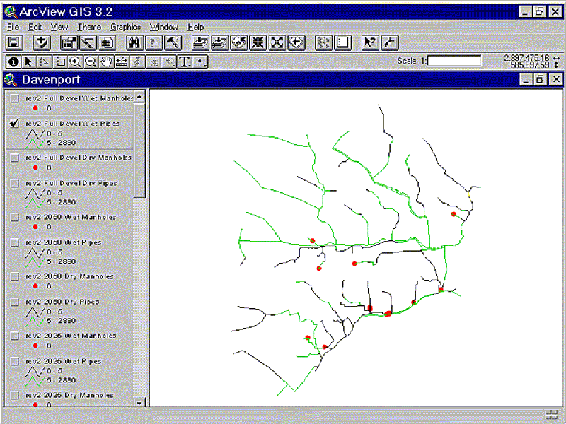
Figure 3 shows full development land use in Davenport. Existing land use data for Davenport were provided in ArcView shapefile format. Future land use for Years 2025, 2050, and Full Development were provided as hand mark-ups on paper maps. The hand mark-ups were digitized with CAD over the top of existing land use and roads layers and then converted to ArcView shapefile format.
Existing and future land use data for Bettendorf were provided as paper maps. The land use maps were digitized with CAD over the top of the roads layer and then converted to ArcView shapefile format.
Figure 4 shows major and sub- drainage basins for Davenport, developed as a part of this project. Basin boundaries were based on existing sewer locations and topography. The major basin names were based on local creeks. The subbasins were developed to be 40-100 acres in size and further divide the major basins. The subbasins were the default "resolution" of the hydraulic model since land use was aggregated by subbasin and the model used 1 to 3 flow inputs per subbasin.
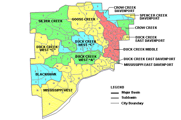
Figure 5 is a schematic diagram of the data flows utilized in this project. ArcView GIS was used as the central data hub to manage the data.
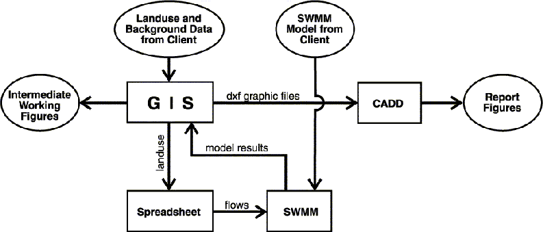
The land use, base layer, and sewer data were provided in or converted to ArcView shapefile format. GIS computed the land use data required as an input to the hydraulic model. These computations are described in more detail under the Computations section below.
A spreadsheet synthesized the input data and created ASCII input files for the SWMM hydraulic model to use. Input data included land use, land use flow factors, flow data from a flow monitoring database, and diurnal dry and wet weather curves. While the SWMM hydraulic model could have been run entirely within its software, the use of ASCII input files sped up the running of multiple scenarios. The spreadsheet allowed for quick changes in flow factors to be made that would affect the entire study area. These alternatives would have required manual changes to thousands of flow inputs without the use of the ASCII input files.
The SWMM model simulated sewer flows for each modeling scenario and produced output files. Visual SWMM had some graphical capabilities, but often the model results were imported directly to ArcView for display. A custom Avenue script pulled pertinent data out of the standard SWMM output files and linked it to the sewer and manhole shapefiles.
Figure 6 presents a typical display showing surcharging sewers and flooding manholes. Using GIS allowed for rapid assimilation of model results by the modeler and overlay with the base data layers. Problems were quickly identified and changes made in input data or sewer parameters to adjust the model. ArcView was also used to create intermediate working figures and prepare data for the final report figures.
Final report figures were generated in CAD. There were several reasons for using CAD rather than ArcView. First, Stanley Consultants has many more CAD operators than GIS operators as well as existing CAD standards and borders. This made the final production of over 77 color report figures more efficient. Second, ArcView's effectiveness in producing high quality figures is limited, especially when compared with the precision and reproducibility available from CAD.
In addition to being the central data hub, GIS was also very useful in performing land use computations essential to the modeling process, including data verification and subdividing the land use features. The ArcView Geoprocessing Wizard provided the tools for these computations.
The original digitization of the land use data led to shapefiles representing incremental development during a given time period. For example, in order to see the entire development scheme for 2050, it was necessary to view the existing, 2025, and 2050 land use shapefiles together. Before these could be combined in a single shapefile, overlapping features had to be eliminated.
The land use shapefiles were checked for overlap with the "union" and "combine" functions. When displayed together, the unioned and combined shapefiles quickly identified the offending features. This information was given to the CAD technician to make adjustments and the process was repeated. In a similar manner, the land use shapefiles were also checked against future years. This verified that there were no overlaps between different time periods. Once each time period's shapefiles were checked, they were unioned with the shapefiles from preceding time periods.
In order to compute flows for each subbasin, the land use and subbasin shapefiles were unioned. This in effect utilized the subbasins as a "cookie cutter" to split land use features that fell into more than one subbasin. The area for each feature or shape in the unioned shapefile was computed. The tabular data resulting from these operations had one row for each land use feature in each subbasin. This data was readily exported to the spreadsheet where, as described above, flow and other factors were applied to create the SWMM hydraulic model input files.
The flow factors used in the spreadsheet were derived from flow monitoring data. The land use and subbasin GIS layers were used to determine the land use mix upstream of many of the individual flow meters. By examining many different basins, standard flow factors in terms of gallons per day per acre (gpd/acre) were developed for residential, commercial, and industrial land uses. The factors were 1000 gpd/acre for residential, 1500 gpd/acre for commercial, and 3000 gpd/acre for industrial.
This project demonstrates the successful use of a wide range of software tools with GIS as the central data hub. GIS, spreadsheets, hydraulic models, and CAD were each used where their inherent strengths best benefited the project. GIS was an essential component in managing the data flow from these separate components. In addition to its use as a data management tool, GIS lent itself to land use computations that were critical inputs to the hydraulic model.
Stanley Consultants, Inc.; Davenport-Bettendorf Wastewater Master Plan, Final Report. Stanley Consultants, Inc; 2001.
The author wishes to thank his wife Rachel; Patrick McGrath and his staff at the City of Davenport Engineering Division; Wally Mook and his staff at the City of Bettendorf Public Works Department; and Patrick Mullin, Brian Roth, and John Sayles of Stanley Consultants, Inc.