While many school groups monitor local water quality, the addition of the GIS component added significant dimensions to the project. In terms of scientific literacy, participating students engaged in ongoing investigations of a watershed, not simply their local water quality. This enlarged perspective enabled students to place their data in a larger context offered through use of the data reported by peers in other schools. In addition, the use of map layers such as land use patterns and the location of known discharge sites in the watershed promoted much deeper spatial analysis of the water quality data. Through this process, students developed an appreciation of the interconnectedness of ecological phenomena. In a very literal sense, they came to understand that what happens locally affects everything downstream.
Instead of simply learning a few concepts and moving on to the next unit, students were challenged to think critically about their data, consider alternative explanations, and support their conclusions to their peers. Pedagogically, teachers and students were able to engage in longer-term, more intellectually stimulating investigations. As is true with most investigations of real-world phenomena, students crossed traditional academic boundaries as they developed skills in, and understanding of, several disciplines including:
Science: water quality, interaction of biotic and abiotic components of an ecosystemIn addition to the professional development workshop sessions and the ongoing support provided to these teachers, the Missouri Botanical Garden also initiated GIS-enhanced programs for children ages 10-12 through its Summer Science Academy. These popular courses have now sold out in each of the three years in which we have offered them-a clear indicator of their appeal to students and their parents. From a project management perspective, these Summer Science Academy courses have afforded program staff an opportunity to assess first-hand how well students are able to make use of GIS and related data tools. The perspectives gained through these courses offer an informal research and development laboratory for new directions in teacher professional development. For example, students' strong interest in (and demonstrated ability to work with) aerial photography and satellite imagery has led to the integration of these components into workshops for teachers.
Math: data analysis and graphing techniques
Geography: map reading and spatial analysis
Language Arts: reading for information and public speaking skills
In all, eighteen teachers from across Missouri participated in this yearlong professional development program. Over time, they developed the strategies and skills needed to support investigations of weather and climate patterns and signs of seasonal change, such as monarch butterfly migration and tulip emergence. The primary focus of the year was to integrate the weather monitoring component of the GLOBE program (www.globe.gov) and the environmental tracking of seasonal change supported by the Journey North (www.learner.org/jnorth) program into sustained classroom investigations. Throughout, teachers and students were encouraged to investigate how weather and climate had an impact on the ecological phenomena tracked.
As with the water monitoring project, GIS played an integral role, as students mapped their data and analyzed it in the context of related data. In this case, the data was provided by others participating in the Mapping the Environment project and by students across the world participating in GLOBE and Journey North. The spatial component of the project promoted the development of age-appropriate scientific understanding as students placed the timing of local phenomena, such as the first tulip emergence or the first monarch butterfly sighted in the spring, in the context of the sightings contributed by others. By noting the distinctive patterns of migration and seasonal change, and correlating these data with weather data, students enhanced their understanding of the complexity of nature.
Several improvements in classroom pedagogy also emerged through participation in the project. All teachers participating in this aspect of the Mapping the Environment project reported to our external evaluator productive changes in their classroom practice, including a much greater use of authentic data in class (in place of static textbook concepts), use of maps of that data, and use of extended inquiries instead of shorter isolated lessons. In addition, most teachers reported that they engaged in a great deal of learning themselves. This example of the teacher as a more experienced fellow learner presents a much more powerful role model to the students than the traditional image of the teacher as the source of all knowledge.
Along with the investigations conducted by the eighteen teachers participating in this component of the Mapping the Environment program, all ten teachers participating in the first watershed monitoring program continued to be actively involved in their monitoring program. With a second year of data available, students and teachers were able to evaluate ideas developed by students in the first year of the project. For example, school groups were able to confirm annual cycles such as the drop in dissolved oxygen levels each fall, and gather further data in support of hypotheses developed by previous participants that land use in the industrial areas down stream contributed to a decline in water quality.
To support continuing improvement in the watershed program, we implemented three specific enhancements for the 2000-2001 school year: (1) Designated monitoring dates; (2) Training in the GLOBE water quality monitoring protocols to improve accuracy in data collection; and (3) Use of trained adult volunteers to expand the network of testing locations.
Teachers participated in the designated monitoring dates to address a weakness in the data set collected during the previous year. While we had approximately 80 collection dates during that year, the fact that the water testing occurred at the convenience of individual teachers made it difficult to make spatial comparisons. For example, a rise in the recorded pH downstream may be indicative of a change in water quality, or it may simply be an artifact of the upstream testing taking place shortly after a rain storm (with the pH being lowered through the acid content of the rain). By removing the test date as a variable, students could more confidently draw conclusions about the spatial variation in the data.
Through the GLOBE protocols, teachers and students had a reference point for data collection and analysis. While their previous training through the Missouri Stream Team equipped teachers with the skills needed to support student use of test kits, the GLOBE program helped in the handling of discrepant data. Instead of simply counting the first measure, or averaging three wildly discrepant values, the GLOBE protocols helped teachers and students to think critically about the quality of the data being collected and what data to report to their peers. Through this process, the reliability and validity of the water quality data set was improved.
Finally, use of the trained volunteers enabled new sites to be tested, doubling the number of data points available on the designated testing dates discussed above. This program has also provided an entr�e into a new constituency for the Mapping the Environment program: adult citizens interested in environmental monitoring. As the program web site goes online this summer, we hope to expand out ability to provide a data exchange forum for these community members.
Modules currently available include:
A Quick Guide to Viewing Data-This introductory module covers the basics of GIS including how to display themes, rearrange their order, zoom in and out, and color code data through the legend editor. Students also gain experience in mapping tables of data keyed to latitude / longitude points.Mapping Seasonal Change, Part I: Exploring Climate Patterns-In this module, the climate data included in the Esri "GIS For Schools and Libraries CD-ROM" is mapped and analyzed to detect regional and annual patterns. Students construct maps and graphs of NOAA weather data and draw comparisons between their local community and other parts of the United States. (This module is an expansion and enhancement of an existing Esri activity for K-12 schools.)
Mapping Signs of Seasonal Change, Part II: Exploring Signs of Seasonal Change-This module builds on Part I, as students map tulip and butterfly data from the Journey North project and interpret it in light of the weather data mapped previously. Questions include issues of how one year compares to another and how weather affects tulip growth.
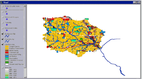
Mapping a Watershed- This module illustrates how to use GIS to interpret water quality data collected from several sites within a watershed. Specific factors of land use, discharge permits, and density of impermeable surfaces help students to analyze a measured drop in water quality downstream.
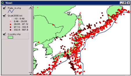
Mapping Natural Hazards-Students map patterns in earthquake locations and then analyze factors such as the locations of larger and smaller earthquakes, or the relationship between the depth of the earthquake and its proximity to a plate boundary. Similar investigations of volcanoes and tornadoes promote understanding of key earth science concepts. Investigations of hurricanes and floods are planned for the fall.
We have additional modules in currently development to support the Jason Project (www.jasonproject.org), and expect eventually to be able to offer a comprehensive series of middle school science curriculum supplements.
Our professional development opportunities continue to grow as well, with summer institutes expanding to two separate offerings of a Mapping Natural Hazards program. One will be in St. Louis, and one in Springfield, Missouri, each co-presented by Dr. Melida Gutierrez, an assistant professor in the College of Natural and Applied Sciences at Southwest Missouri State University. We are pleased to have 11 teachers in the St. Louis workshop from the Maplewood-Richmond Heights School District, which is implementing GIS as a strategic part of their effort to fundamentally redefine their curriculum around technology-enhanced, community based inquiry. The Springfield workshop will enable the program to develop a cadre of teachers in the southwestern part of the state who are able to support each other locally.
Later this summer, we will be establishing a web presence, with published student investigations, inquiry suggestions, and links to the curriculum modules we have developed.
Based on a major funding commitment received by the Missouri Botanical Garden to support Mapping the Environment, we will expand out teacher training efforts in the summer of 2002 to include the development of master teachers who will undergo advanced training. Upon completion of this training, they will be paid stipends to assist the Mapping the Environment program staff in training colleagues in the use of GIS and lead classes for children through our Summer Science Academy program. Through the development of this group of master teachers, we expect to significantly improve the number of teachers and students we will reach.
Also, many thanks are due to Charlie Fitzpatrick, Angie Lee, and George Dailey of Esri for providing software for teachers and advice and troubleshooting. Additional thanks to Elizabeth Howard of Journey North and Greg Cox and Jennifer Lockett of the GLOBE program staff.