Jackson State University (JSU) is a member of the Mississippi Research Consortium and was funded by the U.S. Department of Education to host innovative technology workshops this year, through a catalyst grant. The goal of the project was to infuse technology and hands on science practices in the Mississippi Education System. JSU proposed teaching ArcView GIS to the university and community college faculties, pre-service and in-service teachers with assistance by the Mississippi Automated Resource Information System (MARIS). This paper describes the experiences of teaching different levels of participants and the methodology of training.
Each workshop consisted of the standard two-day Introduction to ArcView course, which was taught by a representative from the Mississippi Automated Resource Information System (MARIS) and Jackson State University (JSU) faculty. The final day of the three-day workshop was dedicated to Global Positioning System (GPS) basics and field training. The ArcView training materials were supplemented with a real world application involving community mapping. Students were given local geographic layers to create custom maps of their business, school or home. These exercises opened discussions about how vast and diverse GIS technology has expanded. The focus of this workshop was to introduce students to GIS technology and also give them a hands on environment in which they actually participated in the collection of original GPS data which could then be input into ArcView to produce maps.
The majority of participants in the workshops conducted at Jackson State University were educators. The educators ranged from primary school to university level. While many of these were familiar with computers, very few had ever heard of GIS until the workshop. A concentration on basic GIS terminology was followed by examples of how GIS is used in real world problem solving. Several of the participants expressed an interest in the use of Satellite imagery and how it is used. This type of remote sensing technology can greatly enhance GIS applications, so discussions regarding remote sensing technology became an integrated part of the workshops. Since digital orthophotography is now more readily available to the general public, an understanding about the difference between a scanned, unprojected image and a digitally referenced image was a necessary component of these discussions.
The format of the workshop was similar to the standard Esri Introduction to ArcView course. Each lecture section was immediately followed by a computer lab in which each student completed an exercise utilizing geographic data through ArcView. These exercises were expanded to include a community mapping project and an introduction to the internet for retrieving geographic and remote sensing data. The Mississippi Automated Resource Information System (MARIS) web site was highlighted as an example of how geographic databases are set up for data retrieval. Knowledge of projections, coordinate systems, and data formats proved to be critical because it is difficult to fully maximize the usage of these data sets without an understanding of these concepts. Most geographic web sites give users a choice of formats for downloads. Therefore, students must know whether or not they will require ArcInfo versus ArcView or other GIS formats. It was also discovered that a basic understanding of compression software and retrieval methods is germane to successful data procurement as more often than not, many of these data sets are bundled in various compression formats.
Participants were also introduced to other online resources such as the Esri virtual campus. This type of resource is desirable for users because it allows them the opportunity to work at their own pace and review concepts that may be difficult to understand. After learning some basic GIS terms and filtering through the vast array of acronyms, the challenge was to quickly utilize these concepts in practical projects that would enhance their understanding of the terminology. An area of the workshop that emphasized this objective was the group project discussions. Many of the participants expressed a desire to start a project or to enhance an existing project using ArcView. In order to facilitate these discussions in a productive manner, we organized our discussions into three main categories; 1) Project Planning, 2) Project Design and 3) Project Implementation. The project planning portion of our discussions were devoted to ideas about projects. We discussed the types of data that would be needed to make these projects work, and how and where this data could be acquired. We talked briefly about database design and how critical data entry was to the integrity of our information. Next, we discussed the elements of project design. In some cases, the projects would require customization tools that would have to be programmed by a computer analyst. Some projects could be easily produced by using the standard ArcView GUI (graphical user interface). Finally, we discussed project implementation.
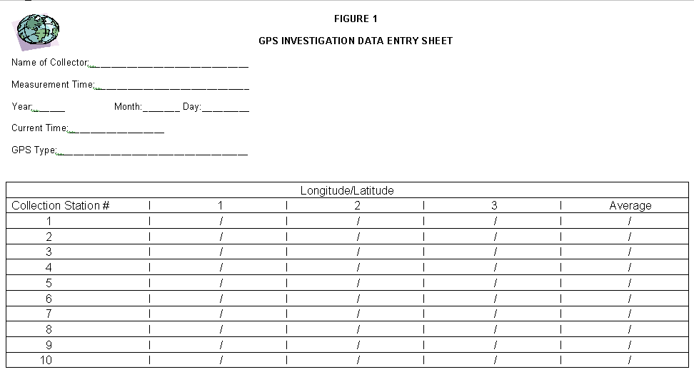
On the third day of training, participants were provided with handheld GPS receivers manufactured by Magellan. Figure 1 Ten collection stations were set up around the Jackson State University campus. A basic lecture on GPS and remote sensing was taught to familiarize the students with some field methodologies and terms. Participants then collected longitude and latitude data from the GPS stations and registered the satellite coordinates onto GPS data entry sheets. Figure 2 The data was then input into ArcView projects for analysis. A tutorial remote sensing CD was also distributed to the participants. At the end of the three-day workshop, participants evaluated the program and made comments about the workshop and instructors.
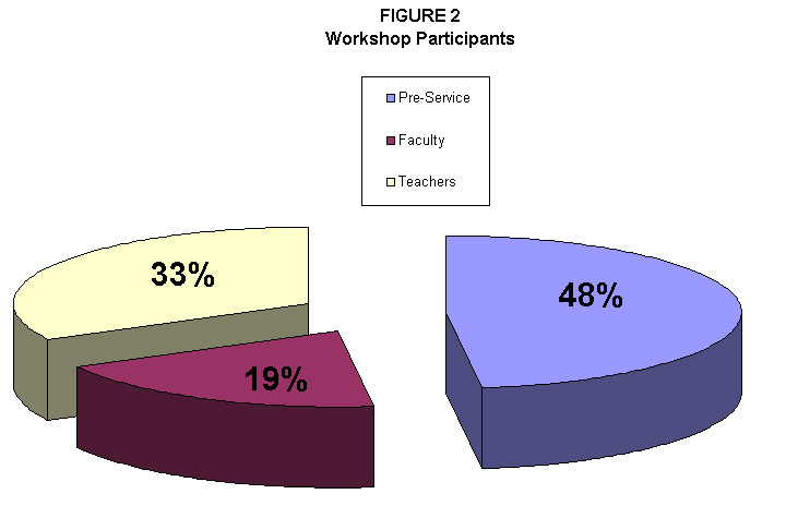
The workshops consisted of several types of educators, some of which had little or no computer experience. We used three categories to define the educators; Faculty, Teachers and Pre-Service Teachers. The faculty category included college professors and administrators. The teacher category included elementary, primary and secondary teachers, while the pre-service teachers included graduate, or graduate students who had not yet received any professional teaching experience. Figure 3
The diversity of the participants posed an interesting challenge for the workshop instructors. Some of the participants had used ArcView and were familiar with GIS and remote sensing technology. Others had limited computer experience. In some cases, there were exercises that took the experienced users only a few minutes to complete, but the less experienced users needed more time to complete them. During these periods of inconsistent completion times, we encouraged the more experienced users to log on to various data warehouses and to utilize the Esri virtual campus. In order to assist the less experienced users, we implemented a question and answer session after each exercise. During that portion of the workshop, each participant could describe what areas were confusing or more interesting than others. There were also a few cases where we found errors in the course book or course data.
The different levels of computer and GIS experience made it necessary to restructure the format of the workshops, in order to balance the training materials. If there is a diverse group, it is more difficult to meet their individual needs. Groups that have a similar background or experience level can share ideas and often complete the exercises at a similar pace. Therefore participants who exhibited a more advanced level of knowledge were encouraged to work beyond the scheduled work exercises and familiarize themselves with more advanced terminology. We also found that many of the participants preferred the real world exercises that applied to their community or business rather than the standard exercises that are taught in the Introduction to ArcView course. Data acquisition was found to be critical, as many retrieval methods and formats must be understood in order to procure good data. Basic metadata topics may be implemented in future workshops as a result. Working with efficient computers and reinstalling the training data after each workshop is recommended. Participants tend to save their exercise projects, causing the original project to differ from the book illustration in future workshops. We also found that smaller workshops of 6 to 10 individuals is more effective than having a larger group. Exercises are much longer when participants have to share a computer. Also, discussions are more productive in a smaller group.
The authors would like to thank Jackson State University for supporting this program and providing the facilities to hold the workshops. We also thank the Department of Technology, workshop participants, student workers, Magellan GPS, Esri and especially the U.S. Department of Education for funding this project.
Rusti Liner, M.S.
GIS Project Manager, Mississippi Institutions of Higher Learning
MARIS Technical Center
Phone: 601-432-6360
Fax: 601-432-6893
email: rustil@ihl.state.ms.us
Author Link
Pao-chiang Yuan, Ph.D. CHMM
Professor, Jackson State University
Department of Technology
Hazardous Materials Management Program
Phone: 601-979-2489
Fax: 601-979-2344
email: pcyuan@yahoo.com