Abstract
Geographic information systems (GIS) technology and methods have transformed decision-making in universities, government, and industry by bringing digital spatial data sets and geographic analysis to the desktop computer. Some educators consider GIS to be one of the most promising means for implementing educational reform. However, GIS technology has been adopted by only 1% of American high schools. The reasons behind the interest in GIS technology and methods, their slow implementation, their extent in the curriculum, and their effectiveness in teaching and learning are unclear.
To address these concerns, this research: (1) describes the geographic and curricular extent to which GIS technology and methods are being implemented in secondary education in the United States, (2) explains why and how GIS is being implemented, and (3) assesses the effects of inquiry‑based lesson modules that use GIS technology on teaching and on the acquisition of standards-based geographic content and skills. A survey of high schools that own GIS software provided primary data to describe and explain the extent of the implementation. A set of pre- and post-test experiments and case studies in three Colorado high schools provided primary data for assessing the effects of GIS.
GIS provides the opportunity for issues-based, student-centered, standards-based, inquiry-oriented education, but its effectiveness is limited primarily by social and structural barriers. Technological barriers to the adoption of GIS, such as limited hardware and software, were found to be less significant than time required to develop GIS-based lesson modules, inadequate student access to computers, inadequate training, and pressure to teach a given amount of content during each term. GIS is being implemented primarily by veteran science teachers at public high schools who perceive that GIS provides real-world relevance, provides interdisciplinary education, and increases student interest. These teachers persist in developing and implementing inquiry-based GIS-based lesson modules despite perceived lack of time and training. sults of experiments with standardized and spatial analysis tests were mixed, although students using GIS performed significantly better on their assignments than those using traditional methods. Case studies showed that GIS changes teacher and student roles, communication, and methods of teaching and learning.
The Research Problem
Geographic information systems (GIS) technology and methods have transformed decision-making in society--in government, academia, and industry. Some educators consider GIS to be one of the most promising means for implementing educational reform. However, GIS technology has been adopted by less than 2% of American high schools. The reasons behind the interest in GIS, its slow implementation, its extent in the curriculum, and its effectiveness in teaching and learning are unclear.
To address these concerns, this research describes the geographic and curricular extent to which GIS technology and methods are being implemented in American secondary education, explains why and how GIS is being implemented, and assesses the effects of GIS-based lesson modules on teaching and on the acquisition of standards-based geographic content and skills.
The first goal of this study was to describe the extent to which GIS is implemented in secondary education in the United States. A review of the related research showed that although GIS and educational reform in geography are each separately in the mainstream of research, the combination of GIS and education clearly is on the periphery. Most of the literature on the extent of implementation came from anecdotal accounts, rather than from national or regional analyses.
This study's second goal was to explain why and how GIS is implemented through an analysis of challenges and catalysts. Diffusion research and a few GIS implementation models provided a framework within which to analyze implementation. The third goal was to assess the effectiveness of GIS on secondary geography teaching and learning. Studies thus far showed mixed results in a few classrooms scattered across the country. GIS-based lesson modules are few and the technology is largely untested. The expansion of GIS as an educational tool, despite its slow diffusion in education compared to business and industry, far outpaces the associated research in its implementation and effectiveness. Research thus far has emphasized teaching about GIS, rather than teaching with GIS (see Sui 1995). It is still unclear how and why GIS is being implemented in the high school curriculum both on a national level and within individual schools, and what difference it really makes in education.
Connecting GIS to Tenets of Educational Reform
The unprecedented attention to geography education at all levels since 1985 may be strengthened and extended with the aid of properly-applied GIS technology. The U.S. Labor Secretary's Commission on Achieving Necessary Skills (SCANS) stated that the most effective way to teach skills is "in context" (U.S. Department of Labor 1991). The SCANS competencies include identifying and using resources, working with others, acquiring and using information, and understanding complex interrelationships (Hill 1995a and 1995b). Interdisciplinary education, rather than teaching each subject in isolation from the others, may be a more effective means to help students solve problems (Jacobs 1989). Implementing GIS into the curriculum may encourage students to examine data from a variety of fields (Furner and Ramirez 1999; Sarnoff 2000).
Since the publication of the first national content standards in geography (Geography Education Standards Project 1994), social studies (National Council for the Social Studies, National Task Force for Social Studies Standards 1994), science (National Research Council 1996), and technology (International Society for Technology in Education 2000), educators nationwide have been progressing toward a model of "inquiry-based" instruction that emphasizes a hands-on, research-based learning experience. Inquiry draws upon learning theory known as constructivism, which holds that rather than being transferred from teacher to student, knowledge is constructed by the learner based on his or her own experiences (Driver et al. 1994).
The Geography Education Standards Project (1994) stated, "the power of a GIS is that it allows us to ask questions of data." Students using the inquiry approach form research questions, develop a methodology, gather and analyze data, and draw conclusions.
A lack of research on the effectiveness of geographic technology identified in a 1967 National Council for Geographic Education study is still the case nearly 35 years after its publication: "Newer media, such as the overhead projector and the film cartridge, also have been seized upon by geographers as effective tools in geographic education. Yet the research-oriented geographer and educator have paid scant attention to assessing the effectiveness of one tool over another (Gross 1967). The organizers of the first conference on educational GIS asked: "What is the learning that GIS allows that other ways do not?" (Salinger 1994). Nothing less than a full answer to the question will suffice.
National GIS In Education Survey
A mailed survey of 33 items was sent to 1,520 high school teachers who owned a GIS package, to describe the extent to which GIS technology and methods are being implemented in the USA. No assumption was made as to whether the teacher was actually using GIS. The best approximation to surveying teachers using GIS in the curriculum was a list of teachers who owned a GIS software package. A listing of teachers owning any one of three brands of GIS software was procured and became the survey's sampling frame. The national survey revealed that GIS has not made significant advancements in terms of the number of secondary schools using it. Over 500,000 users of ArcView GIS exist worldwide (Environmental Systems Research Institute 1999), but less than 1,500 users were in the database of educators.
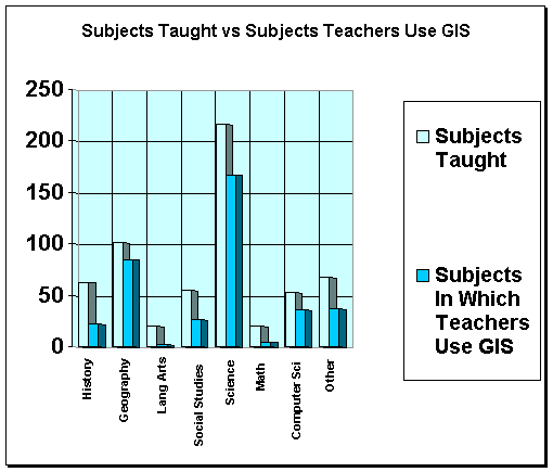
The number of high schools owning one of three main GIS software packages numbered less than 1,900, representing fewer than 5% of all secondary schools. Even among teachers who own GIS software, nearly half are not using it. To put it another way, the state of the art is far beyond the state of practice (Means 1994). Only 3% of schools in the U. S. are effectively integrating technology into all aspects of their educational programs (according to Viadero 1997). Those who are using GIS do so in a wide variety of settings, in different degrees, and in many ways, ranging from preparing maps to be used as tests and on overhead projectors, to incorporating it into fieldwork and with global positioning systems (Figure 1). Only 20% of teachers using GIS use it in more than one lesson in more than one class. GIS is being implemented in standard-sized schools and classrooms, primarily by veteran science teachers. Science teachers outnumbered geography teachers by approximately two to one in the use of GIS. Chemistry teachers were the most-represented single group, primarily through water quality studies.
Figure 1. Subjects Taught vs. Subjects In Which Teachers Use GIS.
Although technological and administrative support is lacking, teachers who have adopted GIS are enthusiastic and active. Lessons are constructivist, reformist, and interdisciplinary in nature, emphasizing teaching with GIS in a content area, rather than teaching about GIS. Implementing GIS is a complex process; evident in such survey data as lag periods of up to several years between the time teachers obtain GIS software and the time they implement it.
Despite a growth in GIS implementation in education, the survey revealed several patterns that signify restraints on its expansion. Even more telling of the challenges teachers encounter when implementing GIS is that nearly half of all responding teachers (45. 1%; n=370) are still not using GIS in the curriculum. These include teachers who indicated that they are “not yet” using GIS or that they “plan to” use GIS in the future (Figure 2).
Considering that the survey is biased toward GIS adopters than nonadopters, it is likely that less than half of the total population of secondary teachers owning GIS software are actually using it.
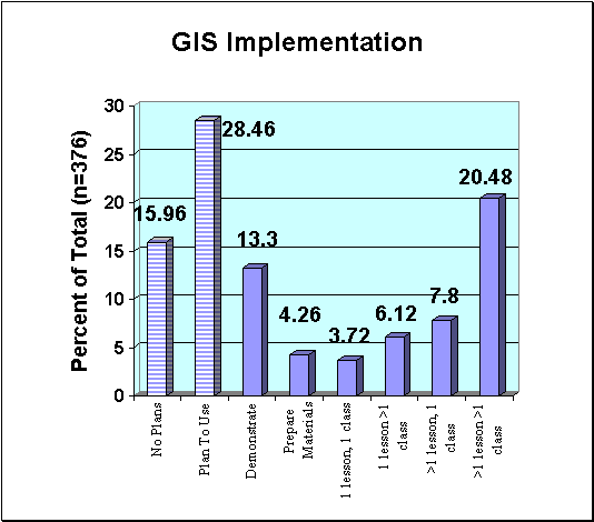
Figure 2. Extent of GIS Implementation in the Curriculum.
Measuring the time between the date that the software was obtained and the date that the teachers began using it in the curriculum indicates that implementation challenges exist. In less than half of the cases (44.4%, n=351) did the teacher obtain and begin using GIS in the same academic year. In 35.9% of cases, a one-to-two year delay occurred, and in nearly one out of every five schools (19.7%) at least three years; delay took place. In 17 schools, the delay was over five years.
Teachers are first trained in GIS largely through inservices. Preservice teachers have little opportunity to learn about GIS. Positive factors in implementing GIS fall mostly on the learning side, while on the teaching side, some are negative. A lack of education-specific training, time to prepare lessons, and the complexity of the software are the chief challenges to implementing GIS. Providing real-world relevance, integration of different subjects, providing an exploratory skill, and enhanced learning and motivation are cited as the main benefits.
Teachers were asked, "To what extent will you use GIS next year compared with this year?" They could choose among decreasing use, maintaining present use, or increasing their use. Even though GIS cannot be quickly mastered and implemented, teachers are apparently willing to invest in making it a success. Indeed, the teachers were enthusiastic about the technology. Nearly three out of four teachers (71.9%; n=327) planned to increase their use of the software; only 4.3% planned to decrease their use (Figure 3).
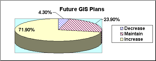
Figure 3. Teachers' Plans for Future Use of GIS.
The large amount of time teachers spend with GIS indicates both their enthusiasm with the tool and also the time-intensive nature of mastering and using it in the curriculum. Most teachers are so enthusiastic about this technology that they invest their own time to learn it. Over 62% of teachers said that they spent at least one hour per week outside of class time with GIS. Over 21% of teachers using GIS were using the tool at home. Teachers, already under pressure to perform a host of other tasks each semester, were willing to invest their personal and professional lives in this tool. The fact that most of these teachers have been in the profession at least 20 years adds significance to this finding: they are more likely to carefully consider the advantages and disadvantages to GIS, rather than "jumping on the bandwagon" of technology. Their acceptance of the tool encourages others to adopt it, rather than to dismiss it as a fad.
Most teachers (88%; n=342) believed that the use of GIS makes a significant contribution to learning (Figure 4). Only 1.8% of teachers did not believe that GIS made a significant contribution, and 10. 2% were uncertain. Part of the explanation for the overwhelming support is because the surveys were sent to teachers who had originally expressed an interest in and obtained GIS software. There is also a natural reluctance to disclose that something a person has invested in is not worth the effort that was spent. Still, the evidence is clear that teachers, despite the challenges, believe that GIS is worth it.
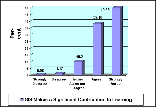
Figure 4. Teachers' Beliefs About the Contribution of GIS to Learning.
There is no mandate requiring the use of GIS in the educational curriculum. However, a small percentage of teachers nationwide have taken it upon themselves to solve problems and conduct workshops to promote its implementation. Convinced of its benefits, these teachers amount to about 15% of survey respondents, and spend a great deal of personal time with GIS.
GIS implementation was examined through a GIS implementation model by Audet and Paris (1997), through Rogers'(1995) diffusion of innovations model, and a social interactionism model. Predictors of GIS implementation in education include good computer file management and database skills, and comfort in giving students the freedom to explore in class. Spatial thinking and the existence of an implementable project should be added to these predictors. The survey showed that the best predictor of a teacher using GIS is if more than one teacher in the school is using it, followed by the number of hours spent in GIS training.
Because GIS is being implemented largely by individual teachers, there may be instructional materials development principles that are not being incorporated into preparing curricula. Most GIS-based lessons are not widely available or easily used, inhibiting the speed of GIS diffusion throughout secondary education.
One teacher conducting a peer training session commented that at the end of the training, a teacher asked, "Can I print out blank outline maps with this program?" This indicates that some teachers view GIS as nothing more than a computerized atlas. Thinking in a different way is perhaps the one factor that hinders GIS implementation in education the most. With advances in accessibility of hardware, software, and data, learning is increasingly dependent on the adaptability of teachers more than accessibility of technology. Powell's (1999) study found that although innovative science curriculum materials do influence teachers'; practice, even more important is whether a teacher's beliefs are aligned with the philosophy of these curriculum materials. The implication for GIS is that only those teachers who value an open-ended, exploratory approach to learning will adopt it.
Teachers felt that the lack of time to develop GIS-based lesson plans was the chief challenge to implementing it in the classroom (Figure 5). These findings suggest that organizations interested in the spread of GIS might maximize their impact on implementation by committing resources toward building these GIS-based lessons.
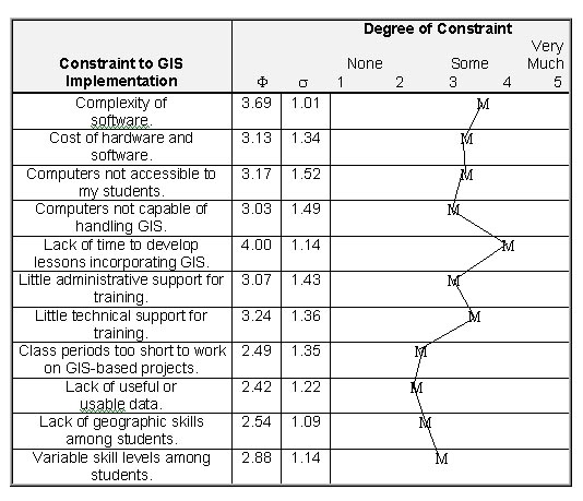
Figure 5. Perceived Constraints on GIS Implementation.
Clearly, GIS is not the type of tool that a teacher can implement into the curriculum as soon as it is obtained, nor can it be easily expanded in the curriculum. This is the irony of GIS--if it were "plug and play," more teachers would use it, but much of the functionality and flexibility would have to be removed. The tool itself has no answers--these come from human operators.
The integration of any technology is driven by a variety of factors, such as the existence of a district or state technology plan, accreditation, peer expectations, student expectations, and whether teachers are evaluated on how they use technology. Motivation and perceived benefit are linked. Teachers decide to implement GIS most often because they want their students to understand data, the relationships among data, and to be able to perform spatial analysis with those data (59 respondents). "Some of our science projects are much more understandable when the data is [sic] analyzed spatially," wrote one teacher.
Next most often, because GIS is a tool developed and used in the professional world, teachers feel obligated to use it (55 respondents). They write as if they have no choice; that the advancements in technology require them to use GIS. Comments such as "it is worth the pain and suffering because it has a fantastic potential and the future applications are tremendous"; show two things. First, the words "pain" and "suffering" show that GIS is perceived as truly difficult, but also, teachers are willing to work through challenges to implement it. It must be remembered that most teachers responding to the survey are not using GIS. If most teachers who have seen demonstrations of the tool are using GIS, it follows that many nonadopters might implement GIS if they could see a live demonstration of it. This has implications for the amount and type of training that should take place for implementation to increase.
Teachers often mentioned that they are using GIS because they had a specific task that they thought GIS could accomplish. GIS meets their need, whether it is analyzing local wetlands or global demographics. The visual capabilities of GIS were often mentioned. Specific job opportunity skills fostered by GIS impelled some teachers to implement it.
Only one teacher decided to implement GIS because of the educational content standards. If teachers do not believe GIS can help them teach the standards, and are increasingly required to teach standards-based lessons, this reveals an important constraint on GIS implementation. Responses to the list of perceived benefits to implementing GIS indicates further perceived benefits and the motivation teachers have for implementing it (Figure 6). Teachers felt that the most important benefit that GIS brings is real-world relevance to curricular areas (mean=4. 14). This is evident in the reasons listed for why they decided to use GIS, with repeated mention of specific projects based on local areas for students to analyze.
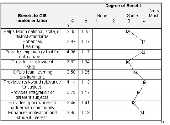
Figure 6. Perceived Benefits of GIS Implementation.
Multiple regression with the degree of GIS implementation as the dependent variable was run to determine the effect that independent variables had on implementation. The number of training hours, the number of years a teacher had been teaching, the number of teachers using GIS in the school, the amount of technical and administrative support, and the number of conferences the respondent attended each year were used as independent variables in the model. The R-squared value was .3030. The model explained about one-third of the degree of GIS use (Figure 7). The number of teachers using GIS in a school had the highest t value, indicating that one can have more confidence that this variable affects the amount of GIS use in a school more than any other. The implication for training is that GIS will more likely be institutionalized in a school if teams of teachers from the same school are trained at the same time.
Because time spent in GIS training was the next most influential variable, training programs are critical if teachers are going to use this technology. After teachers are trained, technical support in the school is a significant factor. Administrative support was insignificant in determining implementation--these teachers use GIS regardless of the support they receive, though they admit that support would aid their efforts. Although many teachers using GIS are veteran teachers, the number of years of teaching was not significant for determining the amount of GIS implementation in this model. GIS-using teachers are active, evidenced by the significance of the numbers of conferences they attend per year.
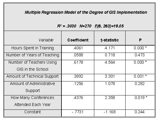
Figure 7. Multiple Regression Model of the Degree of GIS Implementation.
The national survey confirmed the literature review's discovery that despite the presumed utility of GIS tools, a wide gulf remains between the capability of the tools and their implementation. However, many teachers using GIS are doing so in an innovative, constructivist manner that transforms teaching and learning.
The Effectiveness of GIS: Experiments
To supplement the national assessment with a detailed assessment at the local level, a series of experiments and case studies were conducted. One teacher responding to the national GIS education survey, although experienced with GIS, expressed concerns about its effect on learning:
I personally have been troubled with the question of whether students are learning geographic inquiry strategies or merely learning to use a very powerful tool without much thinking about the underlying questions under consideration.
Experiments were conducted in three public high schools in metropolitan Denver, Colorado, USA: Riparian, Hope, and Prairie Vista High Schools (see endnote). The schools were selected based on criteria aimed at ensuring that the schools, courses, teachers, and students would be as equivalent as possible so that experimental results could be compared. First, each school had to have an active, distinct geography program, taught in at least one class for at least one full academic year, where GIS and the national geography standards were used.
The experimental design included the creation of 12 geography lessons, each with two versions—a GIS-based version, and a version using traditional print materials. In each school, experimental groups were sections, or class periods, of a geography course in which students used GIS to complete the lessons. Control groups were comprised of other sections in the same geography course in which students used maps, texts, and paper graphs. Pretests and posttests consisted of "standardized tests" -- based on national, state, and district geography standards, including one from the NCGE (1983), and a spatial analysis test that I created where students chose the best sites for a "Spiffy's" fast food restaurant.
GIS was tested for its influence on the dependent variables--knowledge of geography content and geographic skills, defined by scoring guides based directly on the national geography standards (Geography Education Standards Project 1994). Two-sample t-tests with equal variances were conducted on both the standardized and the spatial analysis tests, and pretest scores were compared to posttest scores via paired t-tests to determine the amount of change over the semester and between each group. Scores from the lesson modules were also analyzed with a two-sample t-test. ANOVAs and t-tests provided data on gender differences. Several regression models were established to investigate the relationship between GIS, pretest scores, and the difference between pretest and posttest scores. Analyses were conducted on individual classes, between classes, in each school, and between schools.
Eighty-seven tests were conducted on data obtained from six experiments conducted in three high schools. The effectiveness of GIS on student performance using standardized and spatial analysis tests showed mixed results in each school and considering all schools together. Spatial analysis test scores either did not change or declined between the beginning and end of the semester. Declining student performance suggests inadequacies with the spatial analysis test and a disincentive for students to thoughtfully complete it at the end of the semester. If a teacher uses GIS, he or she is not able to spend as much time on “testable” content that would appear on a standardized test. GIS did not typically appear to affect the stagnant or downward trend in spatial analysis scores. However, linear and non-linear regression models considering all schools showed that GIS did make a difference in the relationship between GIS and the difference in test scores from the beginning to the end of the semester. Tests on GIS on final course grades suggest that average and below-average students improve more with GIS than above-average students.
GIS did have a significant effect on student performance on the lessons themselves. In four out of nine tests, students using GIS scored significantly higher than their counterparts who were using traditional methods, and demonstrated a better ability to synthesize, identify, and describe reasons for human and physical patterns. GIS appears to improve learning of geographic content, not just skills. Furthermore, GIS fostered higher-order analytical and synthetic thinking, and it also increased students’ knowledge of absolute and relative locations of places across the globe. GIS appeared to affect performance by gender in only four of 26 tests.
The Effectiveness and Implementation of GIS: Case Studies
There is some evidence for the effectiveness of GIS, but the evidence is spotty. Standardized and spatial analysis tests did not fully assess the skills that the research literature revealed that students are gaining with GIS. The standardized test was a typical geography test involving geographic facts and some spatial reasoning. Although the spatial analysis test was created to provide a tool that could more completely assess the skills covered by the GIS lessons, it too was insufficient. To more fully understand the effectiveness, case studies were needed. Case studies took place at the same time as the experiments, so control groups and experimental groups could be observed. Case studies relied on personal interviews with teachers and students, written and oral end-of-semester surveys, and participant observation. Observation took place over an entire academic year.
The case studies hinted that GIS software allows for more creativity, but students are more creative to begin with on the computer. Computers have been a part of their world during their entire school careers. Because GIS requires the manipulation of graphics, charts, maps, and (especially) data, it gives students a fuller practice of the array of computer tools than spreadsheet, presentation, or desktop publishing software alone. Because it involves aerial photographs, field data, satellite images, and maps in a real-world problem-solving environment, it provides students with an idea of the complexities of the world in which they live, and usually of their own communities. Students wrestled with data relevance and data quality, identifying relationships and drawing interpretations.
Case study teachers adopted GIS because it introduces technology to the students and to geography, provides a way to address the geography standards, and matches their constructivist teaching style. GIS increased the teachers' ties to the surrounding community and to their own professional community. Teachers use technology, including GIS,in many different ways. Inquiry-oriented learning with GIS can be difficult and time intensive. Although the computer lab manager's involvement was found to be critical, overall computer issues were secondary to the time required to create and maintain lessons and data, structure of the school day, school politics, and spatial thinking.
GIS increased student motivation for geography, altered communication patterns with fellow students and with teachers, stimulated students who learn visually, and reached students who are not traditional learners. Inquiry-oriented learning through GIS requires teachers and students to tolerate uncertainty, take risks, and to change their traditional roles. Studies of human cognition indicate that broad, well-organized knowledge is crucial for building on what has already been learned and for problem solving (Glaser 1984). The case studies showed that one of the chief constraints on GIS learning is not hardware or software, but the spatial perspective of teachers and students. Most students lacked this spatial perspective and were uncomfortable with the problem-solving style of learning of which GIS takes advantage.
Hypotheses Revisited
Research results supported six of the original nine hypotheses. First, social, educational, and political factors were found to be more important influences on implementing GIS technology in education than technological factors. Second, implementing GIS tools in high-school curricula fundamentally alters the manner of teaching in the classroom. Teachers who favor the analytical, problem-solving style using a variety of media are attracted to GIS. Third, implementing GIS alters the manner of learning, where students grapple with the same issues using the same tools as those in government and industry. Fourth, although their teaching philosophy and style usually did not change, instructional methods that teachers use with GIS are more closely aligned with the tenets of modern educational reform than methods the teachers used before the introduction of GIS. Certainly, teachers can use reformist methods without GIS, but GIS requires teachers to deal with unknown results in an environment where the teacher is a facilitator of knowledge. Fifth, GIS technology and methods are implemented in the secondary curriculum primarily through the efforts of individual teachers, rather than via a systematic, national educational agenda. Sixth, a greater amount of professional development and contact with the local community is associated with teachers using GIS than with teachers who do not use GIS.
Two of the nine hypotheses were not supported, and one was supported only in part. First, the introduction of inquiry-oriented lessons that use GIS tools and methods did not consistently increase the geographic skills as measured by the national geography standards of secondary-school geography students to a greater extent than did the same lessons that did not include GIS. Of the 87 tests conducted, only 18 showed that GIS made a significant difference. Second, female students using GIS did not demonstrate a greater increase in skills over the course of a semester than did male students using the same technology and lessons. Rather, few gender differences were noted. Third, the use of GIS strengthens inquiry-oriented, problem-solving skills, but also strengthened traditional locational geographic skills and knowledge. GIS does strengthen standards-based skills and encourage spatial analysis but GIS also increased locational geographic knowledge.
Implications of This Study
Teaching with GIS has not become institutionalized; it relies on a teacher to act as the driving force. Most teachers have not even reached the awareness stage in Binko's(1989) four stages to learning. This study's results imply that preservice education should include technology, geography, and GIS. Bednarz (1999) recommended that teachers be taught with GIS in the same manner as they will teach their students, with real world problems to experience how this model of learning works. Geography as a whole suffers from a lack of preservice training (Boehm et al. 1994). Bednarz and Audet (1999) went so far as to state that "until consensus is reached that GIS has a role, then we will continue to see a directionless patchwork of [teacher training] programs (p. 66). Without an effective preservice component, GIS implementation will be confined largely to inservice training, which will keep the implementation rate slow.
The predominance of science teachers' use of GIS over geography teachers imply that geography teachers have less computer access and training and their training is less constructivist in nature than their science teacher counterparts. Preservice and inservice training for geography teachers needs to be strengthened so that geography teachers feel confident that they can employ an open-ended, computerized tools in the classroom.
Learning with GIS implies that the teachers' role is still critical to learning, to provide goals and guidance. Otherwise, untargeted tinkering with the system is likely to increase computer and data skills, rather than meeting content goals. GIS has the power to help teachers without a geography background to teach the subject because of the difficulty of developing spatial analysis-based lessons with paper and pencil. The finding that GIS benefits below-average students implies that it should not be confined to the best students.
GIS does not appear from this research to enhance the inequities in schools found by authors examining other computer-based instruction (Pisapia 1994). However, GIS may narrow the types of skills necessary for success because it forces students to use graphics and computer technology. Rogers (1995) grouped individual adopters into five categories regarding their innovativeness: innovators, early adopters, early majority, late majority, and laggards. Socioeconomic status, personality variables, and communication behavior influence the appropriate category. Teachers using GIS today are all innovators, This study implies that GIS implementation cannot be effective without reform, and that reform can be expedited by GIS implementation. Technology is a key component of reform. The renaissance of geography education implies that as geography skills among both students and teachers improve, the use of GIS will become more effective.
Recommendations and Final Considerations
Insight could be gained by conducting a longitudinal study of the same schools, a national resurvey, the inclusion of K-8 and university instructors, learning styles, better assessments, and an affective analysis. Educationally-based curriculum materials need to be developed with an easy-to-use GIS package capable of performing robust spatial analysis and problem-solving. I believe that the geographic perspective is in high demand partly because of the success that GIS users have had in solving problems. I recommend that teaching with GIS be used as the primary method of integrating geographic thinking into other disciplines. Finally and perhaps most importantly, I recommend that the approach to GIS should not be, "How can we get GIS into the curriculum?" but "How can GIS help meet curricular goals?"
This study was entitled "The Implementation and Effectiveness of Geographic Information Systems Technology and Methods in Secondary Education, because GIS was found to be more than just a technology, but also a method. The methods that GIS uses to understand the world make GIS attractive to those advocating educational reform. These same methods, more than the tools, make GIS difficult to implement. GIS allows students to do geographic and scientific analysis, not just read about the results. For GIS to be effective, schools must build an environment of curiosity about investigating the world. Downs (1994) advocated an empirically and theoretically sound, practical, relevant base of knowledge for geography education. This dissertation provides lesson modules that teachers can test in their own classrooms. It is hoped that this study will encourage others to pursue avenues of research and development to take advantage of GIS technology and methods to improve the quality of education.
References
Audet, Richard H., and Joshua Paris. 1997. GIS implementation model for schools: Assessing the critical concerns. Journal of Geography 96(6): 293-300.
Bednarz, Sarah Witham. 1999. Impact and success: Evaluating a GIS training institute. Proceedings, 19th Annual Esri User Conference. San Diego, California. July. http://gis.Esri.com/uc99/proceed/papers/pap895/p895. htm. Last visited:22 September 1999.
Bednarz, Sarah Witham, and Richard H. Audet. 1999. The status of GIS technology in teacher preparation programs. Journal of Geography98(2):60-67.
Binko, James B. 1989. Spreading the Word. Washington, DC: National Geographic Society.
Boehm, Richard G. , John Brierley, and Martha Sharma. 1994. The Bete Noire of geographic education: Teacher training programs. In A Decade of Reform in Geographic Education: Inventory and Prospect, edited by Robert S. Bednarz and James F. Petersen. Indiana, Pennsylvania: National Council for Geographic Education, pp. 89-98.
Downs, Roger M. 1994. The need for research in geography education: It would be nice to have some data. Journal of Geography 93(1): 57-60, January-February.
Driver, R. , H. Asoko, J. Leach, E. Mortimer, and P. Scott. 1994. Constructing scientific knowledge in the classroom. Educational Researcher 23: 5-12.
Environmental Systems Research Institute. 1999. Opening session address, 19th Annual Esri User Conference. San Diego, California. July.
Furner, Joseph M., and Monica Ramirez. 1999. Making connections: Using GIS to integrate mathematics and science. TechTrends 43(4):34-39.
Geography Education Standards Project. 1994. Geography for Life: National Geography Standards. Washington, DC: National Geographic Research and Exploration, 272 p.
Gross, Herbert Henry, editor. 1967. Research Needs in Geographic Education. Normal, Illinois: National Council for Geographic Education, 55 p.
Hill, A. David. 1995a. Geography standards, instruction, and competencies for the new world of work. Geographical Education 8(3):47-49.
Hill, A. David. 1995b. Projections and perceptions. Editorial comments: Learning for the new world of work through geographic inquiry. The Geographical Bulletin, 37(2): 65-67.
International Society for Technology in Education. 2000. National Education Technology Standards for Students: Connecting Curriculum and Technology. Eugene, Oregon: International Society for Technology in Education, 373 p.
Jacobs, H. 1989. Interdisciplinary curriculum: Design and Implementation. Alexandria, Virginia: Association for Supervision and Curriculum Development.
Means, Barbara, editor. 1994. Technology and Education Reform: The Reality Behind the Promise. San Francisco: Jossey-Bass, 232 p.
National Council for the Social Studies National Task Force for Social Studies Standards. 1994. Expectations of Excellence: Curriculum Standards for Social Studies. Washington, DC: National Council for the Social Studies, 178 p.
National Research Council. 1996. National Science Education Standards. Washington, DC: National Academy Press, 262 p.
Pisapia, John. 1994. Technology: The Equity Issue. Richmond, Virginia: Metropolitan Educational Research Consortium. Research Brief # 14, 4 p. ERIC Document Reproduction Service Number ED 411 340.
Powell, Janet Carlson. 1999. The relationship between teachers’ beliefs and the use of reform-oriented science curriculum materials. Ph. D. Dissertation, University of Colorado, Boulder.
Rogers, Everett M. 1995. The Diffusion of Innovations. 4th ed. New York: Free Press, 519 p.
Salinger, Gerhard L. 1994. Remark at the First National Conference on the Educational Applications of Geographic Information Systems. In First National Conference on the Educational Applications of Geographic Information Systems (EdGIS) Conference Report, edited by Daniel Barstow, Michelle Decker Gerrard, Peggy M. Kapisovsky, Robert F. Tinker, and Vickie Wojtkiewicz. 27-29 January 1994. Conference held in Washington, DC. Cambridge, Massachusetts: TERC Communications, 123 p.
Sarnoff, Herschel. 2000. Census 1790:A GIS project. Computers in the Social Studies 8(1). http://www.cssjournal.com/sarnoff.html. Last visited:16 January 2000.
Sui, Daniel Z. 1995. A pedagogic framework to link GIS to the intellectual core of geography. Journal of Geography 94(6). November-December, pp. 578-591.
U. S. Department of Labor. 1991. Secretary's Commission on Achieving Necessary Skills (SCANS) Blueprint for Action: Building Community Coalitions. Washington, DC: Government Printing Office.
Viadero, Debra. 1997. Unplugged. Teacher Magazine. November-December.
Joseph J. Kerski, Ph.D.
Geographer: Education/GIS
USGS
Box 25046 - MS 507
Building 810 - Denver Federal Center - Entrance W-5, Room 3000
Denver CO 80225-0046 USA
http://rockyweb.cr.usgs.gov/public/outreach/
jjkerski@usgs.gov
Telephone 001-303-202-4315
Fax 001-303-202-4137
Research Conducted at the University of Colorado, Boulder